Striding Edge

A photo diary of Lake District fell walks

  • Dogs
  • Contact
  • Fells
    • Wainwrights
      • Eastern Fells
      • Far Eastern Fells
      • Central Fells
      • Southern Fells
      • Northern Fells
      • North Western Fells
      • Western Fells
      • Outlying Fells
    • Birketts
  • Information
    • About Striding Edge
    • Striding Edge
    • T&C’s
    • Privacy
    • Links
  • Walking Diaries
    • 2025 Walking Diary
    • 2024 Walking Diary

Black Fell from Tarn Hows

Walked on 06/11/2025

Start Point: NT Car Park (SD 327 995)

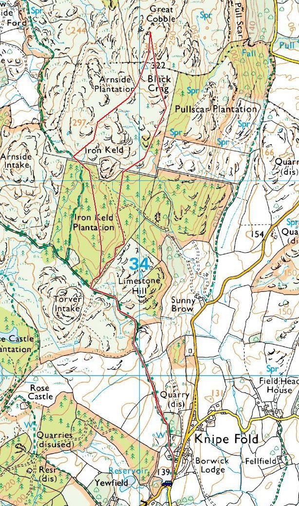
NT Car Park (Tarn Hows) – The Tarns – Iron Keld – Black Fell (Black Crag) – South East Cairn – Iron Keld – Tarn Howes – NT Car Park (Tarn Hows)

Distance: 7.6 km
Total Ascent: 153 metres     
Time Taken: 2 hours   
Start Time: 09:50
Weather: Grey and overcast but warm for the time of year. 12ºC
Finlay’s Wainwright count: 6/214 (1 new this walk)

Route Map

It was nice and sunny this morning at home but by the time I made it to Coniston, the skies were grey and overcast. I was set to walk from Tarn Hows around Black fell then Holme Fell but decided to leave Holme Fell for another day when there are some clearer skies. It was unseasonably warm today and this walk was completed in shirt sleeves which is remarkable for November. It was also very still with barely a breath of wind, all of which combined to make this a really lovely walk. Once I was a quarter of the way along the outward path along Tarn Hows there was no one around until I was back to the main path. Of course the car park was full when I got back but there was the special treat of coffee and cake at Joey’s Cafe waiting for me!

694A5787

All is calm down at The Tarns with only a few people about. Up on the top are the belted Galloway cows that inhabit the area. They must be used to people and dogs as they seemed very docile when we passed and never even gave us a second glance when we passed some of their brethren later on in the walk.

694A5788

Iron Keld Plantation between Tarn Hows and Black Fell.

694A5791

It made me feel old walking through Iron Keld Plantation - when I first walked this way 25 odd years ago, it was a thick pine forest. Over the years I have seen that felled and a new woodland landscape emerge - there are still some pines but mainly Birch trees now and they seem to be coming on well.

694A5799

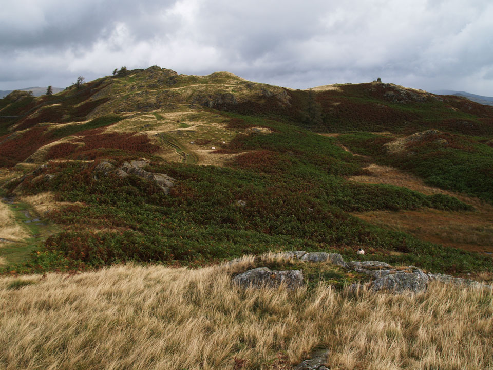
We made a small detour to spot height 297m (on the O.S map) for no reason really - there were no views today as the clag was down low. This made for a walk in silence apart from some distant chainsaw action and there wasn't a breath of wind.

694A5801

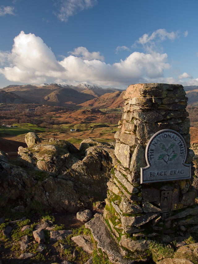
Blag Crag, the summit of Black Fell looking over High Arnside.

694A5809

Where is this Black Crag you speak of? Wainwright #6 for Finlay.

694A5814

Windermere just about visible.

694A5816

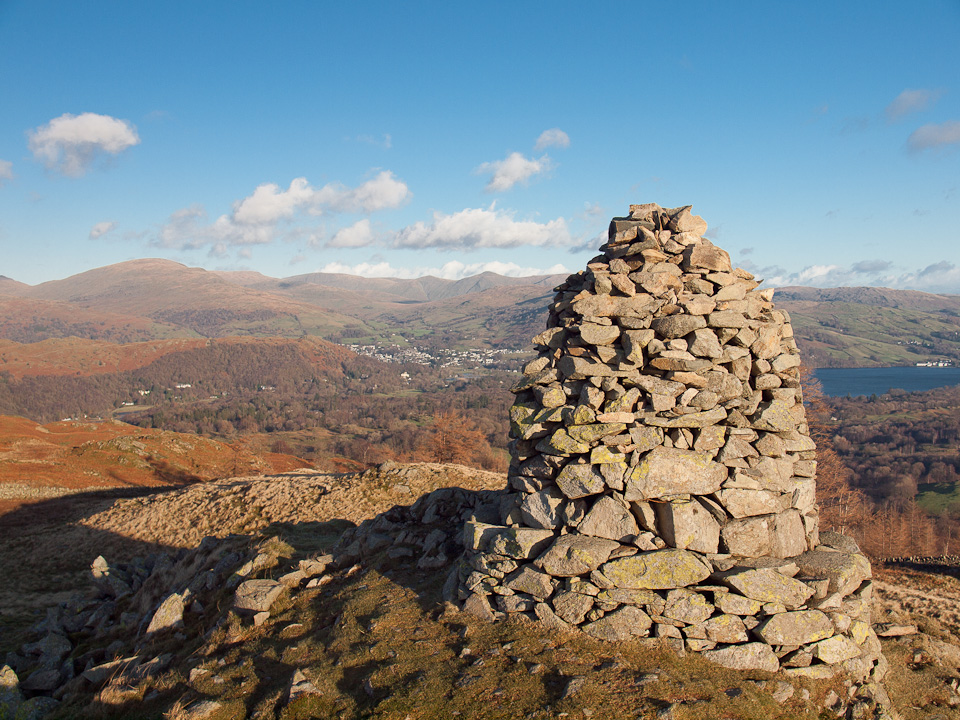
The south east cairn below with Esthwaite water beyond.

694A5827

Down at the magnificent cairn.

694A5829

Esthwaite Water from the cairn. As we walked back towards Iron Keld I could see a bird in the treetops and it was making a strange 'bop bop' noise. I couldn't for the life of me think what it was - a Rook perhaps? Answers on a postcard please if anyone knows...

694A5841

At the Scott Memorial above Tarn Hows. We had to tippy toe past some of those Belted galloway's to get here. As I mentioned earlier, they never even looked at us even though we had to walk through the middle of their small herd.

694A5843

Holme Fell beyond The Tarns - if the weather had been a bit better I may have taken that in as a round trip but maybe next time.

694A5850

Finlay at the memorial.

694A5856

Reflections back at Tarn Hows, the ripples caused by Finlay having a dunk, at least it cleaned all the mud off him. The good thing about finishing here is that there is a coffee wagon at the car park with a good selection of cakeys to go with it.

Black Fell

Walked on 13/11/2015

Start point: Knipe Fold (SD 391 994)

Black Fell from Knipe Fold

Distance: 3.4 miles     Total Ascent: 215 metres     Time Taken: 1 hour 15 minutes     Start Time: 09:30

Weather: Strong wind, frequent heavy showers. 6C

There has been lots of ‘weather’ around all week – rain, wind, hail – you name it. This morning didn’t seem so different when I set off in full waterproofs but I thought it didn’t turn out so bad in the end really…

01-Black-Fell.jpg-nggid0517151-ngg0dyn-0x0x85-00f0w010c010r110f110r010t010

610_1564

Hmmm, today didn't seem to be too promising. There were frequent heavy hail showers and the sky was duller than dull as I headed for the top of Black Fell.

610_1567

A dusting of snow on Helvellyn and Fairfield.

610_1571

...when I turned around I could hardly believe it! The wind had blown through the cloud and there was blue sky and the odd bit of sunshine around.

610_1574

Looking across to Bowfell and The Langdale Pikes.

610_1575

Sunshine on The Old Man.

610_1588

Looking back to Tarn Hows and Coniston Water.

610_1589

Where are we?

610_1591

Lingmoor Fell lit up by the sun.

610_1599

It was all I could do to stay upright the wind was so strong - here is a fleeting moment of sun and clouds that tells the story of the day quite well.

610_1601

The summit looking to Coniston.

610_1610

Close up on Helvellyn and Fairfield.

610_1618

What's the weather like Fletcher?

610_1624

Dougal takes it a little more regally than Fletcher.

610_1631

A wider view of the Eastern fells.

610_1633

The Fairfield Horseshoe.

610_1637

Drama over Windermere.

610_1642

The south east cairn.

Black Fell (Black Crag)

Height: 323 metres / 1060 feet Grid reference: NY 34023 01591 Category: The Southern Fells

Black Crag, the summit of Black Fell is to the left with the trig column visible

Black Crag, the summit of Black Fell is to the left with the trig column visible

The summit column

The summit column

The south east cairn

The south east cairn

Black Fell

Walked on 05/01/2012

Start point: Knipe Fold (SD 391 994)

Black Fell from Knipe Fold

Distance: 3.4 miles     Total Ascent: 215 metres     Time Taken: 1 hour 15 minutes     Start Time: 12:45

Weather: Sunny with a cold, strong wind. 5°C

I didn’t think we would see any clear skies today, it was blowing a gale all night and most of the morning with frequent heavy showers. Everywhere was wet underfoot as you might imagine and once out of shelter the wind was still quite strong but thankfully it blew all the rain clouds far away.

OLYMPUS DIGITAL CAMERA

A submerged jetty at Low Wood shows how much rain there has been around this week but the strong winds of last night and this morning have blown it all clear again.

OLYMPUS DIGITAL CAMERA

The tide line shows how high the water has been.

OLYMPUS DIGITAL CAMERA

Looking across Windermere to Crinkle Crags, Bowfell and the Langdale Pikes. On with the walk...

OLYMPUS DIGITAL CAMERA

A pastoral view to the east from the track from Knipe Fold.

OLYMPUS DIGITAL CAMERA

Casper and Dougal on the throne initialled 'CD'...made for those two, obviously!

OLYMPUS DIGITAL CAMERA

The view through Iron Keld plantation to Windermere. The Low Wood Hotel (where the first photos on this page were taken) is the white building centre right.

OLYMPUS DIGITAL CAMERA

'The Woolly Jumper' - I don't know what Dougal was up to but I stopped for a second and boi-oing, he was up here as quick as a flash, up a 7 foot wall in a single leap. Get him signed up for the Olympic squad quick!

OLYMPUS DIGITAL CAMERA

Black Crag, the summit of Black Fell is to the left with the trig. column visible. To the right is the large south-east cairn.

OLYMPUS DIGITAL CAMERA

The Langdale Pikes and High Raise with Lingmoor Fell in the foreground.

OLYMPUS DIGITAL CAMERA

A wider view across Low Arnside.

OLYMPUS DIGITAL CAMERA

Dougal and Casper on the summit.

OLYMPUS DIGITAL CAMERA

Black Crag, the summit of Black Fell.

OLYMPUS DIGITAL CAMERA

The view from Great Cobble.

OLYMPUS DIGITAL CAMERA

Helvellyn and Fairfield.

OLYMPUS DIGITAL CAMERA

Despite the sunshine it was still blowing a hoolie up here.

OLYMPUS DIGITAL CAMERA

Looking across Ambleside to the Far Eastern fells.

OLYMPUS DIGITAL CAMERA

Close up on the Langdale Pikes.

OLYMPUS DIGITAL CAMERA

Crinkle Crags and Bowfell.

OLYMPUS DIGITAL CAMERA

The boys check out the best way to the south east cairn, Esthwaite Water beyond.

OLYMPUS DIGITAL CAMERA

Windermere, the Howgills to the right.

OLYMPUS DIGITAL CAMERA

The south east cairn.

OLYMPUS DIGITAL CAMERA

Helvellyn to the left, the Fairfield fells to the right beyond Great Cobble.

OLYMPUS DIGITAL CAMERA

Esthwaite Water from the descent.

OLYMPUS DIGITAL CAMERA

Moon rising to the east.

OLYMPUS DIGITAL CAMERA

The Howgills to the left, Latterbarrow with the large obelisk visible to the right. On the way back...

OLYMPUS DIGITAL CAMERA

Dreamy Coniston Water.

Black Fell

Walked on 21/09/2009

Start point: Knipe Fold (SD 391 994)

Black Fell from Knipe Fold

Distance: 3.4 miles     Total Ascent: 215 metres     Time Taken: 1 hour 15 minutes

Weather: Very dull with showers. 15C.

Today was a complete contrast to last week with the weather being really dull and threatening throughout the walk. It was a big day for young Dougal though as he completed a walk to his first Wainwright summit, something he managed with aplomb and he got a taste of the changeable Lake District weather for good measure!

Black-Fell

Black Fell route map.

21.09.09-013

Approaching Iron Keld, the felled plantation.

21.09.09-019

It was so dull this morning here heading through Iron Keld. In fact it was almost dark, which made it really difficult to get any photos of anything.

21.09.09-041

Windermere from Black Fell.

21.09.09-074

Casper and Dougal on Black Fell, Dougal's first Wainwright summit.

21.09.09-080

Ambleside and Windermere during a passing shower.

21.09.09-094

'No one told me it would be this windy!'. There are all sorts of colours going on with Dougal now - slate around the eyes and a browny red mixed in with the black.

21.09.09-108

Windermere from the large cairn to the south-east of the summit.

21.09.09-115

Looking back to the summit.

21.09.09-122

We found this 'throne' cut from the stump of a felled tree complete with initials. 'CD'? - it must stand for Casper and Dougal of course!

Black Fell

Walked on 18/01/2007

Start point: Knipe Fold (SD 391 994)

Black Fell from Knipe Fold

Distance: 3.4 miles     Total Ascent: 215 metres     Time Taken: 1 hour 15 minutes

Weather: Very windy with showers. 9°C

This morning it was as windy as yesterday, similar to conditions all over the country I expect. Today’s walk was relatively low to try and keep out of the worst of the weather. The track we used to get to Black Fell is relatively sheltered so that was not so bad; once out onto the open fellside, however, it was a different story as we were battered by the constant wind and returned in driving rain.

Black-Fell

18.01.07-001

First stop today was Tarn Hows to check out the conditions. There were leaden skies beyond The Tarns today.

18.01.07-004

Wetherlam looming large.

18.01.07-014

Walking the track from Knipe Fold to Black Fell - there was even some sunshine

18.01.07-015

Up onto Black Fell and Wetherlam gets some sun.

18.01.07-017

The Helvellyn ridge and Fairfield.

18.01.07-023

Heading for Black Crag, the summit of Black Fell. The trig. column is to the highest point on the left and on the right is the south-east cairn.

18.01.07-040

Windermere from Black Crag.

18.01.07-052

Really strong winds up here today!

18.01.07-057

Looking north from Black Fell to Helvellyn, the Fairfield Horseshoe and Red Screes.

18.01.07-068

Casper keeps his back to the wind, spying something down below.

18.01.07-078

18.01.07-080

18.01.07-081

Tarn Hows.

18.01.07-083

Coniston Water and Tarn Hows.

18.01.07-088

Black Crag, the summit of Black Fell - no mistaking this one.

18.01.07-093

Wansfell Pike on the right with Ambleside nestling between them. Beyond are the eastern fells with the familiar outline of Ill Bell and Froswick behind Wansfell Pike.

18.01.07-096

A windswept Coniston Water from High Hollin Bank.

Holme Fell

Walked on 16/02/2006

Start point: Glen Mary Bridge (NY 321 999)Glen Mary Bridge – Holme Fell – Hodge Close – Oxen Fell – Black Fell – Tarn Hows – Glen Mary Bridge

Distance: 7.3 miles     Total Ascent: 660 metres     Time Taken: 2 hours30 minutesWeather: Dull and overcast, turning to rain. 5°C

More grey skies this morning and it was quite cold – the higher tops all had a dusting of snow on them. At lower level, that turned to rain – at least the rivers and falls were looking good!

Holme Fell

16.02.06-002

Yew Tree Tarn.

16.02.06-010

A beck flowing into Yew Tree Tarn.

16.02.06-021

The Langdale Pikes with a dusting of snow from the top of Uskdale Gap.

16.02.06-026

Close up of Pike o' Stickle and Harrison Stickle.

16.02.06-029

Pike o' Blisco.

16.02.06-032

Wetherlam has snow too, but is under a blanket of cloud.

16.02.06-035

Coniston Water from Holme Fell.

16.02.06-040

Looking north over Hodge Close.

16.02.06-045

Hodge Close quarry.

16.02.06-049

High Oxen Fell farm.

16.02.06-050

Cold Pike, Pike o' Blisco and Blake Rigg from Oxen Fell.

16.02.06-052

Lingmoor Fell from the climb to Black Fell as the rain sets in.

16.02.06-059

Windermere from Black Fell.

16.02.06-067

The Tarns, Tarn Hows.

16.02.06-072

Looking down from the top of Tom Gill waterfall.

16.02.06-074

16.02.06-076

Tom Gill waterfall.


Holme Fell and Black Fell

Walked on 07/08/2003

Two short walks, Holme Fell (69) and Black Fell (70)

013.JPG

Ivy Crag on Holme Fell.

014.JPG

A hazy view from Holme Fell.

015.JPG

Holme Fell highest point.

016.JPG

Iron Keld plantation, currently being demolished.

017.JPG

Black Crag, the summit of Black Fell.

018.JPG

Windermere from Black Fell.

019.JPG

Holme Fell from Black Fell.

020.JPG

Black Fell South-East cairn.