About Striding Edge
StridingEdge since 2003 – Over Twenty Years on the fells!
Striding Edge is the photo diary of Sean McMahon’s fell walks, capturing the beauty and moods of the wonderful Cumbrian landscape. The site contains details of the Lake District’s 214 Wainwright fells and 541 Birkett fells as well as walking routes and guides.
There are regularly updated photos and maps of walks with distances, timings, ascents and route descriptions. Each Wainwright and Birkett Lake District fell has its own information page which includes height details, fell grouping, accurate GPS co-ordinates and a summit photo.
All walks described are provided in good faith, the maps and routes described here are not an indication of right of way, but an indication of general direction only. Any walk undertaken is done so at your own risk. Enjoy the spectacular views!
214 Wainwrights
541 Birketts
20+ Years of Fell Walking
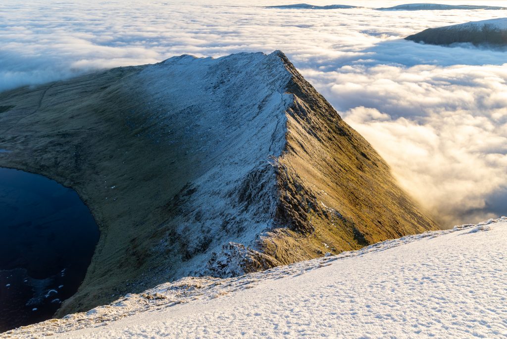
The Ridge: Striding Edge
IMPORTANT SAFETY NOTICE
Any walk undertaken via this website is done so entirely at your own risk. The information provided is a personal record of Sean McMahon’s experiences and is intended for indicative purposes only.
Crossing the Ridge: Only attempt the traverse of Striding Edge if you are experienced and confident in your own abilities. Conditions on the fells can change rapidly. Always carry a physical map and compass, and ensure you have the correct equipment and experience for the terrain.
Striding Edge is the famous and renowned ridge that flanks the south eastern passage to Helvellyn. The most common route to Striding Edge is from Patterdale or a longer walk from Glenridding. The target from either route is to reach the ‘Hole-in-the-Wall’ to reach the best way of traversing the ridge from east to west.
From the Hole-in-the-Wall at 700m, there is a stony climb until you reach the rock tower overlooking the full length of the finest ridge in the Lake District at an elevation of 850m. Crags and scree fall away from either side and portray a breathtaking and quite dramatic scene. The traverse of the edge is relatively easy in normal conditions and can be made easier by following the path that exists alongside and lower than the main arête.
Care should be exercised when there is a high wind or ice as this is a very exposed ridge – a fall from here would be fatal. The trickiest part is at the Helvellyn end when a scramble is required to descend the 7 metres or so of a rock tower known as The Chimney. An alternative and easier descent of this section is shown below. In total, from the Hole-in-the-Wall to the summit of Helvellyn is a distance of 2km with a total ascent of 260m.
Disclaimer & Liability Waiver All information provided on StridingEdge.net, including route descriptions, GPS coordinates, and maps, is for indicative and informational purposes only. While every effort is made to ensure accuracy, fell walking and ridge scrambling are inherently dangerous activities.
By using this website, you acknowledge that:
- Personal Responsibility: You are solely responsible for your own safety and the safety of those in your party.
- Dynamic Conditions: Weather, terrain, and path conditions in the Lake District can change rapidly and without notice.
- Competence: You must possess the necessary navigation skills (map and compass), physical fitness, and appropriate equipment for the chosen route.
- No Liability: Sean McMahon and Striding Edge shall not be held liable for any injury, loss, or damage arising from the use of information on this site.
Always check the mountain weather forecast and carry the appropriate OS map for your route.