Striding Edge

A photo diary of Lake District fell walks

  • Dogs
  • Contact
  • Fells
    • Wainwrights
      • Eastern Fells
      • Far Eastern Fells
      • Central Fells
      • Southern Fells
      • Northern Fells
      • North Western Fells
      • Western Fells
      • Outlying Fells
    • Birketts
  • Information
    • About Striding Edge
    • Striding Edge
    • T&C’s
    • Privacy
    • Links
  • Walking Diaries
    • 2026 Walking Diary
    • 2025 Walking Diary
    • 2024 Walking Diary

Sour Howes & Sallows

Walked on 12/12/2025

Start Point: Browfoot Lane, Kentmere (NY 448 004) – Not recommended!

Browfoot Lane – Capple Howe – Sour Howes – Sallows – Kentmere Park – Browfoot Lane

Distance: 12 km
Total Ascent: 331 metres     
Time Taken: 3 hours
Start Time: 09:40
Weather: Ever improving. 7ºC
Finlay’s Wainwright count: 14/214 (2 new this walk)

Route Map as an indication of the route taken. A better starting point to tackle these fells from Kentmere side would have been Kentmere or perhaps High Borrans.

Setting off along the (very) wet bridleway towards Sour Howes. I parked at the top of Browfoot Lane which is certainly not to be recommended. The lane was covered with quite large potholes and at the top of it, where the road meets the bridleway, there was barely room to park a single car.

This was quite a big day in Finlay’s fell walking career – after doing a lot of recall training it was time to give him a chance off lead and this seemed like the perfect opportunity to do it. The bridleway was walled for long sections with numerous gates so there was no chance of him running off too far! As it happened he was fine and came back every time so the off lead training was extended to the open countryside – he did very well!

There was plenty of low cloud hugging the fell tops, especialy to the east of Kentmere.

Well that was a boggy old trudge but I guess there has ben plenty of rain lately. I ended up going too far and crossing Park Beck before climbing through a gate, which was a mistake as there was no way on to the open fellside that I could see (although I did end up coming from Sallows that way later on) so I retraced my steps and climbed to the right of the wall to the south of the beck. This is looking to Morecambe Bay from one of the Grouse butts on the steep climb.

A fantastic view of Windermere opened up as we climbed, this is taken from the top of Capple Howe.

It is a short walk to Sour Howes from Capple Howe and the view to Threshthwaite Mouth and the head of Troutbeck are tremendous. Wainwright #13 for Finlay!

Sour Howes.

Troutbeck from Sour Howes.

Heading for Sallows, another squelchy affair.

A fine view along some of the Far Eastern fells – Yoke, Ill Bell, Froswick, Thornthwaite Crag.

Red Screes and the Kirskstone Pass road in view.

Finlay on the summit mound of Sallows, #14/214.

There was a lovely, dramatic winter sky looking southwards.

Looking down on Kentmere from the descent from Sallows. On the face of it this should have been a straightforward descent, however someone had placed a herd of cows in the way of us and the path below so special avoidance techniques were required to circumnavigate them!

We successfully negotiated a way down and the skies were ever clearing with even a bit of sunshine now. We walked this path in both directions – Sour Howes is on the left and Sallows on the right.

Williamson’s Monument on Hugill Fell.

Almost back at the car and it was the best part of the day now looking across to Green quarter.

Capple Howe

Height: 445 metres / 1460 feet Grid reference: NY 43216 02893

Capple Howe

Capple Howe

Sallows

Walked on 18/09/2007

Start point: Troutbeck (NY 413 028)

Troutbeck – Garburn Road – Sour Howes – Capple Howe (515) – Moor Head – Sallows – Garburn Road – Troutbeck

Distance: 5.2 miles     Total Ascent: 470 metres     Time Taken: 2 hours

Weather: Clear and cool. 12oC.

After a dull start it eventually turned sunny and bright but it was so cold this morning. A step change I thought and Autumn is most definitely upon us now. This is quite a gentle walk and I managed to pick up a Birkett straggler – one that I had somehow managed to miss previously. I don’t know what has happened to the cairn on Sour Howes, somehow it has completely disappeared without trace.

Sallows

18.09.07-005

Troutbeck Park from the Garburn Road, The Tongue centre.

18.09.07-009

Getting higher up the Garburn Road.

18.09.07-026

Looking across to Scafell, through the Three Tarns gap, and Bowfell.

18.09.07-029

The Coniston fells from the climb to Applethwaite Common.

18.09.07-030

Windermere from the ridge.

18.09.07-035

Thornthwaite Crag, Froswick, Ill Bell and Yoke.

18.09.07-036

Red Screes and Caudale Moor across Troutbeck Park.

18.09.07-040

The sky is clearing now as the sun gets higher giving clear views.

18.09.07-044

A close-up of Bowness and Windermere.

18.09.07-045

Distant Black Combe over Windermere.

18.09.07-046

Crinkle Crags, Scafell and Bowfell. Pike o' Blisco can just be seen to the left of the first Crinkle.

18.09.07-048

Casper on the summit of Sour Howes. The cairn that used to be here has disappeared so Casper will have to do instead!

18.09.07-053

The view to the north from Sour Howes.

18.09.07-057

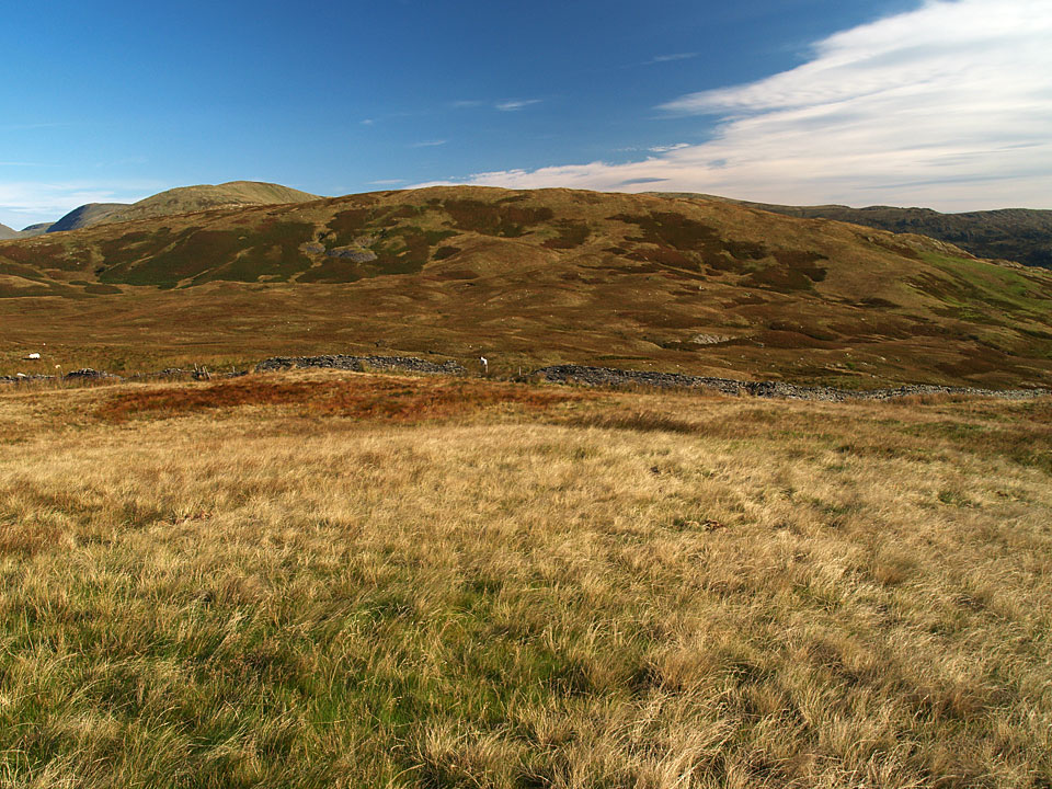
Sallows from the top of Capple Howe. I managed to miss this new (for me) Birkett last time round.

18.09.07-064

Sunshine and blue skies heading for Sallows.

18.09.07-068

The western fells over Wansfell Pike.

18.09.07-069

Red Screes with the Kirkstone Pass road below.

18.09.07-071

The Kentmere Horseshoe fells from Sallows.

18.09.07-073

Yoke over the Garburn Pass.

18.09.07-075

Casper on the summit mound of Sallows, Kentmere Pike beyond.

18.09.07-087

Scafell Pike now visible in the distant centre, Great End over the Langdale Pikes to the right.

18.09.07-090

The Coniston range.

18.09.07-091

Troutbeck Tongue.

18.09.07-096

Descending to the Garburn Road.

18.09.07-098

Black Combe and the Coniston fells from the Garburn Road.

18.09.07-102

Wansfell.