Height: 651 metres / 2136 feet Grid reference: NY 29135 33898 Category: The Northern Fells

Great Sca Fell summit
Little Sca Fell, Great Sca Fell and Knott from Meal Fell
Meal Fell and Great Cockup from Great Sca Fell
Height: 651 metres / 2136 feet Grid reference: NY 29135 33898 Category: The Northern Fells
Great Sca Fell summit
Little Sca Fell, Great Sca Fell and Knott from Meal Fell
Meal Fell and Great Cockup from Great Sca Fell
Start point: Longlands (NY 266 358)
Longlands – Longlands Fell – Lowthwaite Fell – Brae Fell – Little Sca Fell – Great Sca Fell – Meal Fell – Trusmadoor –Great Cockup – Longlands
Distance: 6.9 miles Total Ascent: 673 metres Time Taken: 2 hours 40 minutes Start Time: 10:20
Weather: Warm but windy on the tops. 12oC
Firstly, thanks to all (the many!) who attended the book launch in Keswick and Bowness this weekend, it was great to meet so many of the StridingEdge family and I was humbled by the amount of people that had travelled from far and wide to attend the event and meet Dougal and Casper (and two blokes that have brought a book out!). Thank you.
The weather has completely turned around from my last walk with the temperatures reaching a heady 12C and the snow has completely disappeared from the fell tops now. I wasn’t expecting much from the weather but was pleasantly surprised when the weather was much brighter than expected on these rather dull fells. The wind however was biting up there and it was really quite cold on the tops.


It was a bit dull but Grasmere was flat calm on the way past today.

Binsey and Over Water from the climb to Longlands Fell.

Longlands Fell summit.

It was mighty windy once up on the top (as demonstrated by my able assistant, Dougal) and hat and gloves were required from here.

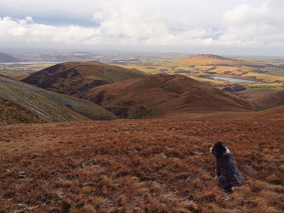
The view to Lowthwaite Fell with Skiddaw to the right beyond Great Cockup.

The small cairn on Lowthwaite Fell.

The route to Little Sca Fell (following the path up to the left).

Drama over Skiddaw.

Looking over to the Solway Firth from Brae Fell.

The path to Little Sca Fell, left to centre.

High Pike and a hint of blue sky.

Sun on Brae Fell.

Lowthwaite Fell and Longlands Fell.

A spontaneous outburst of sunshine.

The sunken wind shelter on Little Sca Fell.

Knott from Great Sca Fell.

The steep descent to Meal Fell, Great Cockup beyond.

A solitary figure walks the path to Meal Fell.

The valley of the River Ellen looking to Over Water and Binsey.

Burntod Gill.

Meal Fell, the summit is the small shelter to the left.

Looking across Meal Fell summit.

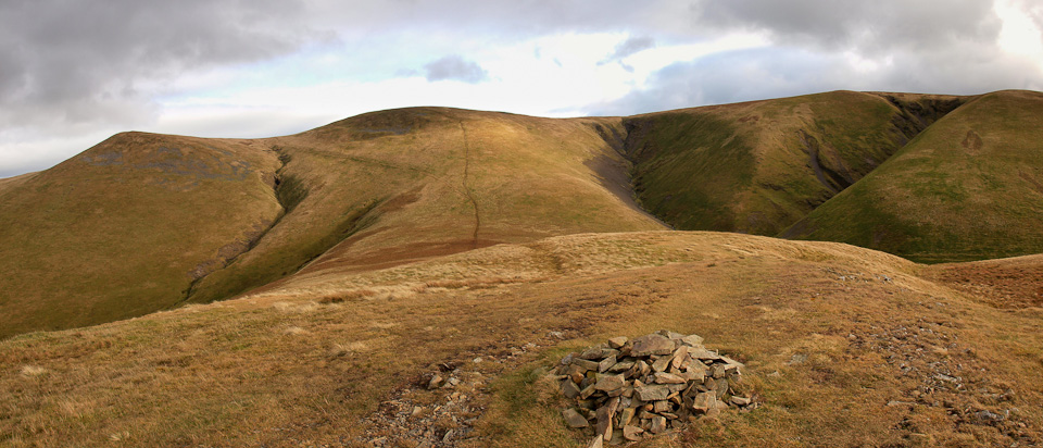
Little Sca Fell, Great Sca Fell and Knott from Meal Fell.

Windswept Casper, nine years old on the 15th November.

Trusmadoor.

The view along Burntod Gill.

The Back o' Skidda' from Great Cockup.

Dougally Doo and Casperoonals on Great Cockup.

Skiddaw panoramic.

Bassenthwaite Lake. Today's tale from the fells...when I was descending steeply towards the River Ellen, I could see by looking at the lie of the land the best route of descent. I could also see a crossing of the River Ellen and a path on the opposite bank marked by the gap in the bracken. The person a little further ahead of me had a hand held GPS at which he was intently gazing. He managed to descend the horribly steep way without lifting his eyes from the screen and continued across a bog towards a crossing of the River Ellen which would have been a nightmare, as it goes into a deep ravine further downstream from the crossing. I could see him looking around for a crossing place when I was well on my way back to Longlands...they are alright those GPS's but sometimes it's better just to look!

Following the wall back to Longlands.
Start point: Longlands (NY 266 358)
Longlands – Brae Fell – Little Sca Fell – Great Sca Fell – Knott – Lowthwaite Fell – Longlands Fell – Longlands
Distance: 6.3 miles Total Ascent: 609 metres Time Taken: 2 hours 20 minutes Start Time: 10:45
Weather: Sunny spells with a cold wind. 6°C
The prediction was for rain and strong winds today but it looked clear further north so I headed to Longlands to walk some of the Uldale Fells. The high fells have a fresh dusting of snow and even these ‘Back o’ Skiddaw’ fells had some lying on the tops. The wind was biting though and the skies to the west looked threatening throughout the walk.

It was beautiful and sunny at the start of the walk following the track from Longlands but the sunshine belies the temperature as there was an icy wind.

Behind there was lots of cloud building up to the west and the prediction was for strong winds and rain.

Heading for Charlton Wath, Brae Fell on the horizon.

Sunshine on the climb to Brae Fell.

Longlands Fell and Binsey from the climb.

Brae Fell summit.

Sunshine and wind for Casper and Dougal.

Dougal heads for Little Sca Fell.

Typical 'Back o' Skiddaw' terrain.

Great Sca Fell.

It's a very similar view from the summit of Knott, looking to High Pike and Carrock Fell.

Great Calva and the Back o' Skiddaw.

Moody and broody through the Glenderaterra Valley.

Blencathra and Mungrisdale Common.

A glimpse of Bassenthwaite Lake.

Meal Fell and Great Cockup from Great Sca Fell - not today though Dougal, the wind has a real bite to it now and is becoming stronger.

The route to Little Sca Fell.

Skiddaw from Little Sca Fell with its sunken wind shelter.

Skiddaw, Bakestall and Dead Crags looking through the gap on the descent to Lowthwaite Fell.


Mega-cairn on Lowthwaite Fell.

Windswept Dougal following the track to Longlands Fell.

Panoramic view from Lowthwaite Fell.

Binsey and Over Water from Longlands Fell.

Too windy!

Black Hawk Down over Chapel House Farm.

Start point: Longlands (NY 266 358)
Longlands – Brae Fell – Little Sca Fell – Great Sca Fell – Lowthwaite Fell – Longlands Fell – Longlands
Distance: 5.1 miles Total Ascent: 520 metres Time Taken: 2 hours
Weather: Mixed, in the mist above 500m. 12C.
I had a trip to the north of the Lakes for a walk around some of the Uldale Fells this morning. There were some sunny spells but it was generally dull with low lying mist on the tops. The going was very wet too after recent heavy rain so it turned into a bit of a squelch around the fells. After the Uldale Fells I had a short drive over to Binsey as part of a ‘Wainwright 3rd time round’ mopping up exercise.

Uldale Fells route map.

Longlands Fell from the bridleway.

Over Water, (the other) Latrigg and Binsey complete with a hint of blue sky and sunshine.

Descending to Charlton Wath and it is all looking a bit murky up on Brae Fell to the right.

Casper tests out the bathing properties of Charlton Wath - but he is definitely on his own in there today!

I walked alongside Charlton Gill for a short way rather than directly ascend the fell side.

The area has been planted with indigenous trees and it has also been fenced off. Free access is allowed though and the fence will be removed in 15 years time according to the sign.

Climbing from the gill now looking at Longlands Fell across the distinctive Saddleback in Charlton Gill.

Little Sca Fell and Lowthwaite Fell from the climb to Brae Fell and here comes the all enveloping mist.

Brae Fell summit.

There were no views at all on the walk to Great Sca Fell and Casper sticks his tongue out to that.

Descending below the mist on the walk from Little Sca Fell. Ahead are Lowthwaite Fell and Longlands Fell with Binsey in the distance.

Over Water and Binsey from Lowthwaite Fell.

Over Water and Binsey from Longlands Fell.

Start point: Longlands (NY 266 358)
Longlands – Brae Fell (484) – Little Sca Fell – Great Sca Fell – Knott – Frozen Fell – Burn Tod – Trusmadoor – Great Cockup – Meal Fell – Lowthwaite Fell (485) – Longlands Fell (486) – Longlands
Distance: 9.75 miles Total Ascent: 970 metres Time Taken: 3 hours 45 minutes
Weather: Very windy with showers. 16oC.
What a day! I passed through major rainstorms throughout the central Lake District to find it fairly clear behind Skiddaw. The tail end of Hurricane Gordon hit while we were up there today though, with very high winds and showers. Although it is usually relatively easy going, the fells being grassy and most unlike other fells in Lakeland, today the wind made the going much tougher.
The Uldale fells are known as ‘The Back o’ Skiddaw’ and are on the northernmost boundary of the Lake District. They certainly are off the beaten track and we completed this circuit without even catching sight of a single soul.


Longlands Fell from the bridleway. This was the last fell of the round later on.

The wind started to pick up during the ascent of Brae Fell and the sun was fleeting in and out. Casper has a look north over to Aughertree Fell with a ghostly figure behind...

It was soooo windy on the summit of Brae Fell. Casper and Angus are lying low - looks like Angus is in the right place, sheltering behind Casper.

Brae Fell.

The weather was not really conducive to taking photos - here is a quick shot of the way ahead to Little Sca Fell up to the right - taken full on into the wind. I could hardly stand up!

Looking back to a sunlit Brae Fell from Little Sca Fell.

Lowthwaite Fell and Longlands Fell from Little Sca Fell. In the distant left are Over Water and Binsey.

Heading to a mist covered Knott from Great Sca Fell.

Still windy and no view on the summit of Knott.

Angus fancies a walk over to Great Calva I think, but it's not on our route today.

The Uldale Fells from Burn Tod.

The sun fleeting in and out again on the steep descent of Burn Tod, here looking to the gap of Trusmadoor. Looking at this photo, it appears to be a nice day; I can assure you it was anything but! The strong wind made every step difficult.

Great Cockup, our next target.

Looking into Frozenfell Gill with Great Sca Fell at its head.

A broody looking Skiddaw from Great Cockup. Skiddaw never came from beneath this cloud blanket all day and it seemed to shelter these northern fells from the worst of the weather.

Meal Fell from the descent of Great Cockup with Little Sca Fell and Great Sca Fell beyond.

Having a rest in the wind shelter on Meal Fell.

Looking into a sunlit Frozenfell Gill.

Rainbow over Brae Fell from Little Sca Fell. The rain was in now, blowing fiercely from behind.

Heading for Longlands Fell from Lowthwaite Fell.

Charlton Gill and Brae Fell during a brief intermission from the rain - it is coming back in from the top right again, though.

Looking over Longlands from the descent of Longlands Fell, Aughertree Fell behind.
Start point: Orthwaite (NY 253 337)
Orthwaite – Orthwaite Bank (162) – Little Cockup (163) – Great Cockup (164) – Trusmadoor – Meal Fell (165) – Little Sca Fell (166) – Great Sca Fell (167) – Knott (168) – Frozen Fell (169) – Burn Tod (170) – Orthwaite
Weather: Wind and rain.
A walk around The Uldale Fells today at the ‘Back O’ Skiddaw’. This area is a real wilderness and in the main the fells are grassy hummocks. A place of solitude, I didn’t see another soul today.


Binsey from the summit of Orthwaite Bank.

The Dash Valley from the ascent of Little Cockup.

Looking across to Longlands Fell and Lowthwaite Fell from Little Cockup.

Skiddaw Little Man, Skiddaw and Bakestall in the foreground from the summit of Great Cockup.

Skiddaw and Bakestall through Trusmadoor from the ascent of Meal Fell. My descent from Great Cockup was the path coming down diagonally from the right while later, on the return, I descended Burn Tod from the left of the photo, crossed Burntod Gill, and followed the path towards Skiddaw.

Little Sca Fell and Great Sca Fell across Trusmadoor from the summit of Meal Fell.

Lowthwaite Fell and Longlands Fell from Little Sca Fell.

High Pike and Carrock Fell from Great Sca Fell.

High Pike from Knott.

Brae Fell, Little Sca Fell and Great Sca Fell from the grassy hump that is the summit of Frozen Fell.

Another contender for the smallest summit cairn in the Lake District, the solitary piece of quartz that marks the summit of Burn Tod. Sale Fell is in the distance on the far side of Bassenthwaite Lake.

Skiddaw and Bakestall from the bridleway that runs to Orthwaite.

'The Boulder' mentioned by Wainwright in The Northern Fells - Great Cockup 2, with Burn Tod behind.

Orthwaite Hall.
Longlands – Charleton Wath – Brae Fell (100) – Great Sca Fell (101) – Great Calva (102) – Knott – Meal Fell (103) – Trusmador – Great Cockup (104) – Little Sca Fell – Lowthwaite Fell – Longlands Fell (105) – Longlands

Skiddaw from Brae Fell summit.

Brae Fell summit.

Knott from Great Scafell summit.

Great Calva and Skiddaw from Knott.

Great Calva.

Ascending Great Calva.

Great Calva summit.

Great Cockup summit.

Meal Fell summit.

Longlands Fell summit.