Height: 801 metres / 2628 feet Grid reference: NY 21472 10716 Category: The Western Fells
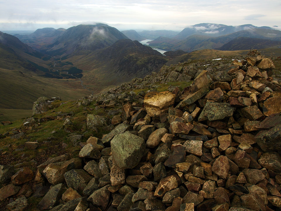
Ennerdale and Buttermere from the summit of Green Gable
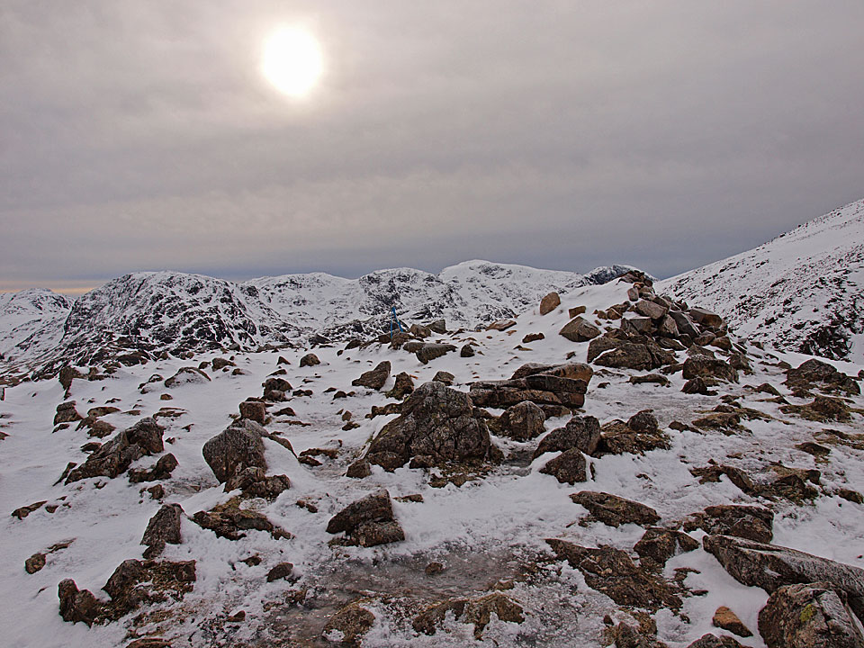
Great End and the Scafells from Green Gable
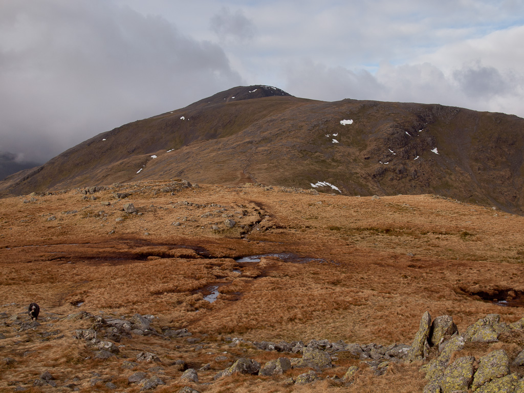
Heading for Green Gable across Blackmoor Pols
Height: 801 metres / 2628 feet Grid reference: NY 21472 10716 Category: The Western Fells
Ennerdale and Buttermere from the summit of Green Gable
Great End and the Scafells from Green Gable
Heading for Green Gable across Blackmoor Pols
Start point: Seathwaite (NY 235 122)
Seathwaite – Hanging Stone – Base Brown – Blackmoor Pols – Green Gable – Windy Gap – Styhead Tarn – Sty Head – Sprinkling Tarn – Great Slack on Seathwaite Fell – Seathwaite Fell – Taylorgill Force – Seathwaite
Distance: 6.2 miles Total Ascent: 925 metres Time Taken: 4 hours Start Time: 07:00
Weather: Changeable, windy. 11oC.
It’s a while since I have done these fells and it was nice to get back there for a visit. The weather was constantly changing and the summits were very windy with the clouds constantly blowing in and off. There was quite a number of dead sheep around today, a grizzly consequence of the heavy snowfall not so long ago.


Base Brown from Seathwaite.

High above Seathwaite Farm.

Seathwaite Fell and Base Brown.

Seathwaite Fell.

Sourmilk Gill.

Borrowdale and fallen branch.

Sunburst over Borrowdale.

Early morning light at the top of Sour Milk Gill.

Base Brown.

Borrowdale from the northern slopes of Base Brown.

The Hanging Stone.

Great and Green Gable from Base Brown.

Heading for Green Gable across Blackmoor Pols - it looks like Dougal has already been!

Looking back to Base Brown.

Ennerdale from Green Gable.

Great from Green.

Great End and Skew Gill from the descent.

Dougal in traditional pose on the stretcher box.

Lingmell and Piers Gill.

Windswept Dougal on Great Slack.

The Wainwright summit of Seathwaite Fell from Great Slack, the highest point.

It was very windy along here but there is blue sky over Keswick way.

The steep descent.

Taylorgill Force.
Start point: Wasdale Head (NY 187 087)
Wasdale Head – Moses Trod – Gavel Neese – Beck Head – Great Gable – Windy Gap – Green Gable – Aaron Slack – Sty Head – Moses Trod – Wasdale Head
Distance: 6 miles Total Ascent: 900 metres Time Taken: 4 hours 15 minutes
Weather: Cold and clear. 2°C
It was a clear night last night and very cold this morning in Wasdale. Once up above 600m, the wind added an extra chill factor and the snow was iced over which meant crampons and ice axe were definitely required. It all made the going quite slow but it was a really enjoyable winter walk and it was very quiet up there today – I didn’t see a single person or indeed a footprint!


Pillar dominates Wasdale head.

Looking into Mosedale.

Great Gable.

Wasdale from the start of the climb to Great Gable.

High Stile and High Crag across the frozen Beck Head Tarns.

Kirk Fell across Beck Head.

Ennerdale and the High Stile ridge with Grasmoor to the right. The Solway Firth and Scotland are clearly visible today through the gap.

Mono Green Gable across Stone Cove.

The climb from Beck Head.

A panoramic view from Beck Head. Select on the image to see a larger version.

Pillar and Scoat Fell across Kirk Fell.

The climb from Beck Head was up iced over snow, so crampons were certainly required today.

Approaching Great Gable summit.

Great Gable summit with the FRCC memorial plaque central.

The sky to the south was quite eerie with the sun trying to burn through, here looking across to the Scafells.

Looking to the south east, there is a big inversion over towards Windermere with Ingleborough visible across the low cloud.

Casper has seen it all before and has 40 winks whilst Dougal seems to be enjoying the view.

The Langdale Pikes.

Wasdale from The Westmorland Cairn.

Casper living on the edge.

Great Hell Gate.

Ingleborough over Allen Crags.

Green Gable from the treacherous descent to Windy Gap.

Looking northwards from Windy Gap.

Great Gable from Green Gable.

A glimpse of Buttermere and Crummock Water from Green Gable.

Great End and the Scafells from Green Gable.

Styhead Tarn from Aaron Slack.

Great End reflected.

Styhead Tarn.

Frozen Styhead Tarn.

Casper on his throne.

Lingmell and Piers Gill.

The way back to Wasdale, looks like Casper and Dougal have spotted something down there.
Start point: Seathwaite (NY 235 122)
Seathwaite – Hanging Stone – Base Brown – Blackmoor Pols – Green Gable – Gillercomb Head – Brandreth – Grey Knotts – Borrowdale Yews – Seathwaite
Distance: 5 miles Total Ascent: 780 metres Time Taken: 3 hours 15 minutes
Weather: Sunny spells. 17C.
I was up at the crack of doom today for a quiet walk around Gillercomb. The weather threatened to clear all the time but the tops remained in cloud mostly, even though further north in Buttermere the sun was shining and it was the same down at valley level too.

Gillercomb Round route map.

Setting off from Seathwaite towards Base Brown it was spotting with rain.

Crossing a pretty dry River Derwent, Seathwaite Fell is prominent.

Clearing sky over Base Brown.

Seathwaite and Borrowdale from the climb.

The view from Sourmilk Gill, Casper hiding amongst the rocks.

The moon setting over Base Brown - Casper seems to know the way!

Borrowdale sunrays.

Fallen Stone, Base Brown.

Hanging Stone - don't sneeze Casper.

The Hanging Stone from the other side.

Wainwright's boulder that has come to rest on a number of small ones.

Seathwaite Fell from he steep climb to the top of Base Brown.

Casper unfurls his tongue as a victory celebration for reaching the top.

Green Gable from Base Brown.

Brandreth and Grey Knotts across Gillercomb, the route of return.

Looking back to Base Brown from the climb to Green Gable.

Ennerdale and Buttermere from Green Gable shortly before I got enveloped in cloud making it pretty cold up here and time to get a jacket on.

Ennerdale.

Green Gable across Gillercomb Head from the climb to Brandreth, Great gable in mist beyond.

The summit of Brandreth. I'm sure that roll of fence posts has been here for years.

Following the fence to Grey Knotts.

Haystacks, High Crag and High Stile in the sunshine.

Pillar and High Stile across an un-named tarn on Grey Knotts.

Looking east over a different tarn towards Glaramara, Combe Head is the prominent point.

At last, a clear view of Haystacks, the High Stile ridge, Buttermere and Crummock Water from the east

Casper has a look too with the Honister mine working visible on Fleetwith Pike.

Base Brown and Green Gable from the eastern - and recognised - summit of Grey Knotts.

Dale Head across Honister.

Base Brown across Gillercomb.

A panoramic view along Gillercomb.

Base Brown and Green Gable.

Seathwaite and the view along Grains Gill.

The John Bankes memorial stone ('John Bankes Esquire 1752' it used to read).

Down at valley level the sunshine was glorious and it was really warm. Casper was in this pool on the River Derwent first, closely followed by me! What better way to spend a few minutes on a Monday morning than having a dip in here?
Start point: Wasdale Head (NY 187 087)
Wasdale Head – Moses Trod – Gavel Neese – Beck Head – Great Gable – Windy Gap – Green Gable – Aaron Slack – Sty Head – Moses Trod – Wasdale Head
Distance: 6 miles Total Ascent: 900 metres Time Taken: 3 hour 35 minutes
Weather: Mainly overcast, cold on the tops. 10oC.
Well it looked promising early on but I can’t grumble about the weather really as it turned out much better than forecast (i.e. I didn’t get wet!). It was a typical November day really and there was hardly a breath of wind until above 700m where there was an icy blast. Today I had my own 2 minutes of silence alone on the top of Great Gable.


Early Wast Water reflections and a touch of blue sky.

The classic shot of Wasdale.

The lake was calm this morning with hardly a breath of wind.

Great Gable from Wasdale Head, the path running up the centre before cutting left is the one I am following today.

Casper lying low in Fogmire Beck.

There is cloud forming and then quickly disappearing from the summit.

Following Moses Trod.

Lingmell Beck.

Looking down on Wasdale Head.

Wasdale Head from Beck Head, The Screes to the left and Yewbarrow to the right of Wast Water.

Kirk Fell across Beck Head from the climb to Great Gable.

High Stile across Ennerdale.

Casper above Ennerdale.

Green Gable across Stone Cove.

Ennerdale and the High Stile ridge.

Pillar beyond Kirk Fell.

There was lots of cloud forming over the fells to the north-west. This cloud was rolling over Brandreth and heading directly towards me bringing a chill wind - time for the gloves, cap and jacket!

Kirk Fell through the enveloping mist.

Next week is Armistice Day and the annual Remembrance Day service takes place on Great gable summit on Sunday. I left our families poppy up there today. 'Lest we forget'...I will not.

The Scafells from the summit of Great Gable.

The Scafells again, this time from the descent to Windy Gap.

Styhead Tarn and Great End from Windy Gap.

The path to Green Gable.

Ennerdale from Windy Gap.

A brief sunny spell over Sty Head.

Ennerdale and Buttermere from the summit of Green Gable.

Kirk Fell, Pillar with a profile of Pillar Rock overlooking Ennerdale with Scoat Fell and Red Pike in view.

Casper on Green Gable.

Strange cloud formations over Coledale way.

Pillar and The Pillar.

Styhead Tarn and Seathwaite Fell.

Trafalgar Square or Sty Head? Casper has a stretch on the stretcher box.

Great End and the cleft of Skew Gill.

Lingmell and the cleft of Piers Gill.

Casper heading for home.

Great Gable and the headstone dedicated to a climber who died up there in St Olaf's churchyard.

More reflections - Great Gable, Lingmell, Scafell Pike and Scafell.

The Screes.
Start point: Seathwaite (NY 235 122)
eathwaite – Hanging Stone – Base Brown (505) – Blackmoor Pols – Green Gable – Gillercomb Head – Brandreth – Grey Knotts – Borrowdale Yews – Seathwaite
Distance: 5 miles Total Ascent: 780 metres Time Taken: 3 hours 30 minutes
Weather: Overcast, the tops in cloud. 8°C
The weather returned to being dull and damp after the rather more glamorous conditions of last Thursday. The tops were in cloud until the very end when the sun made a brief appearance. I can hardly believe it is 3 years since I last visited Base Brown, how time flies! I think conditions were similar last time I was there as well; I must visit it in the sunshine one day.


Here's one for the record, something you don't see very often - the road at Seathwaite deserted! For the uninitiated, there are cars as far as the eye can see in summer.

Base Brown from Seathwaite - all looks a bit gloomy today.

Sourmilk Gill.

Borrowdale, Seathwaite bottom right.

The top waterfall, Sourmilk Gill.

The shattered boulders on the north face of Base Brown.

Borrowdale from above the Hanging Stone (bottom).

Seathwaite Fell and Grains Gill. The cloud is low on the tops.

On the summit of Base Brown.

Heading across Blackmoor Pols.

Gillercomb through the mist. The rest of the walk up to Green Gable then back to Brandreth and Grey Knotts was completely under cover of the mist.

All was eerie and quiet on the summit of Grey Knotts.

Suddenly, on the descent from Grey Knotts, the sun appeared.

Base Brown across Gillercomb from Raven Crag.

Looking across Seatoller Fell and into Borrowdale

Raven Crag from below

Looking to the head of Borrowdale with Allen Crags and Great End behind Seathwaite Fell, from the Plumbago mines.

Thornythwaite Fell and Glaramara across Seathwaite.

Base Brown from the Borrowdale Yews.

The River Derwent.
Start point: Car Park at the head of Honister Pass (NY 225 135)
Honister Hause – Bell Crags – Black Star (440) – Fleetwith Pike (441) – Moses Trod – Beck Head – Great Gable – Green Gable (442) – Gillercomb Head – Brandreth (443) – Grey Knotts (444) – Honister Hause
Distance: 8.75 miles Total Ascent: 1159 metres Time Taken: 4 hours
Weather: Grey and overcast. 5ºC.
Today the weather was a lot duller than yesterday for a walk up to Great Gable from the Honister Pass. It did look promising at the start, but after the ascent of Great Gable I never got out of the clouds until reaching Grey Knotts. It was very quiet up there today and I had every summit to myself, which must be a record for Great Gable I think!


The track from Honister Pass looking down to the slate mine - the only slate mine in England.

Hindscarth from Black Star, the highest point of Honister Crag.

Yewbarrow through the gap between Kirk Fell and Pillar.

The Buttermere Valley from Fleetwith Pike. The nearest water is Buttermere with Crummock Water behind and a glimpse of Loweswater in the distance.

High Crag and High Stile from Fleetwith Pike.

The summit of Grasmoor obscured by clouds.

Haystacks in the foreground with Pillar behind, across Ennerdale.

Angus is back! - on Fleetwith Pike.

High Crag.

Fleetwith Pike to the left of the ridge with Black Star along the same ridge to the right. Much evidence of continuing mining operations here.

Kirk Fell appears fleetingly from the cloud cover.

...as does Green Gable.

A panoramic view of Ennerdale and Buttermere. Select on the image to see a large annotated version.

Angus.

The Ennerdale Valley from the rising of the River Liza which runs all the way to Ennerdale Water.

A glimpse in to Wasdale and a view of Wast Water from Beck Head. Now it was up to Great Gable and up into the clouds.

The Fell and Rock Climbing Club plaque on Great Gable summit with poppies remaining from the Remembrance Sunday service.

The mist clears at Windy Gap to show Styhead Tarn.

A puddle shows how cold it is up on Grey Knotts.

Tarn on Grey Knotts.

Base Brown from the summit of Grey Knotts.
Seathwaite – Hanging Stone – Base Brown (159) – Blackmoor Pols – Green Gable – Gillercomb Head – Brandreth (160) – Grey Knotts (161) – Borrowdale Yews – Seathwaite
A damp day with low lying cloud.


Sourmilk Gill from Seathwaite.

Seathwaite Fell from Seathwaite farm.

Sourmilk Gill from ascent to Gillercomb.

A view of the Borrowdale valley from the ascent of Gillercomb.

Wainwright's Fallen Stone on the way to Base Brown.

The Hanging Stone on Base Brown.

Raven Crag from Base Brown.

A misty Base Brown summit cairn.

Ennerdale appears through the mist from Gillercomb Head.

Tarns on Gillercomb Head.

Brandreth summit with Ennerdale Water just about visible.

Buttermere nearly visible from Grey Knotts summit.

Base Brown from Grey Knotts.

Borrowdale Yews and Seathwaite from the descent of Grey Knotts above the Plumbago mines.

A view up Grains Gill with Glaramara to the left and Seathwaite Fell on the right.
Wasdale Head – Black Sails Pass – Kirk Fell (93) – Great Gable (94) – Green Gable (95) – Windy Gap – Styhead Tarn – Wasdale Head

Looking up Mosedale Beck towards Black Sails.

Looking over the Black Sails Pass to Haystacks and Fleetwith Pike with Robinson, Dale Head and Hinsdscarth in the far distance.

High Crag and Haystacks from Black Sails Pass with Robinson behind.

Wastwater from Kirk Fell summit, Illgill Head to the left and Yewbarrow to the right.

Great Gable from Kirk Fell.

Scafell and Lingmell from Kirk Fell summit.

Kirk Fell Tarn.

A dried up Beckhead Tarn from Kirk Fell.

Great Gable summit overlooking Wastwater.

Wastwater from the Westmorland cairn.

The Scafell Pikes from Great Gable.

View from Green Gable summit with Pillar on the left with Haystacks and High Crag on the right.

Great Gable from Green Gable.

Styhead Tarn from Windy Gap.

The 'cat rock' on Great Gable from the Lingmell Beck path.