Height: 411 metres / 1350 feet Grid reference: SD 23630 95088 Category: The Outlying Fells
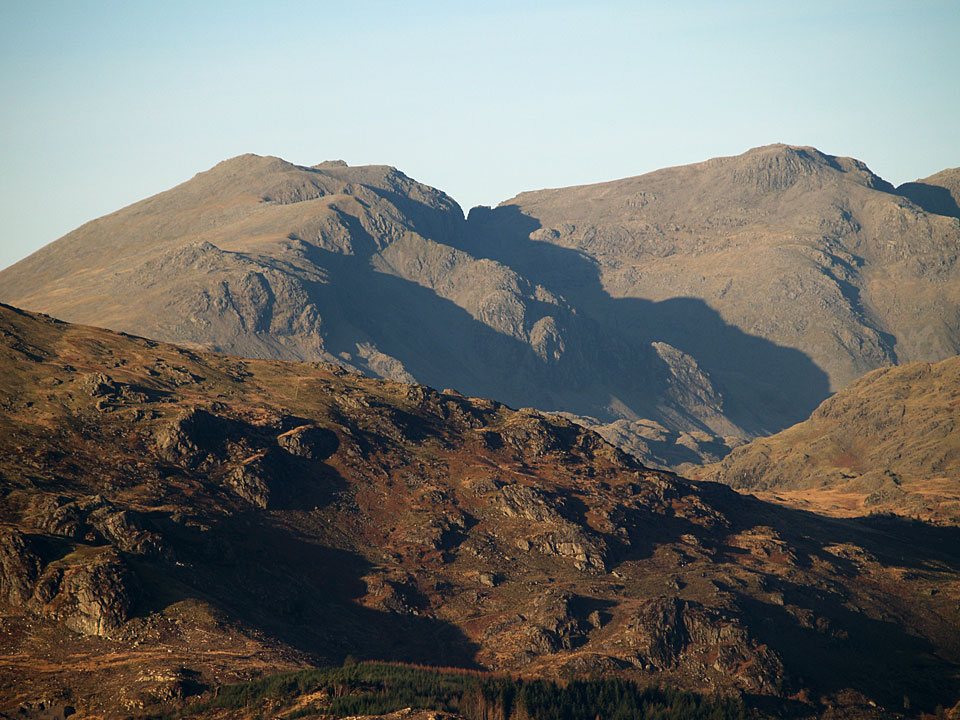
Scafell and Scafell Pike from Green Pike
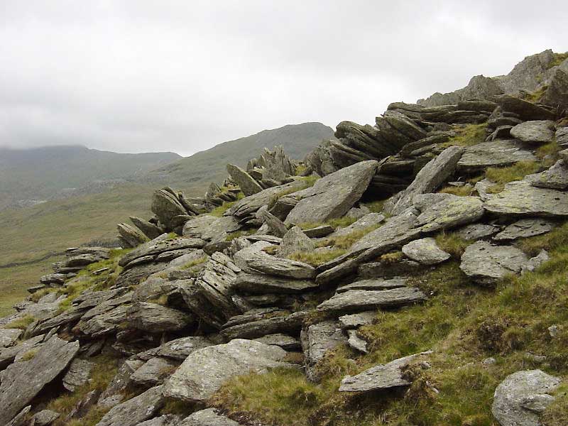
Rock formations on Green Pikes
Height: 411 metres / 1350 feet Grid reference: SD 23630 95088 Category: The Outlying Fells
Scafell and Scafell Pike from Green Pike
Rock formations on Green Pikes
Start point: Seathwaite, Dunnerdale (SD 228 960)
Seathwaite – Park Head Road – Stickle Tarn – Stickle Pike (OF) – Caw (OF) – Pikes (OF) – Green Pikes (OF) – Seathwaite
Distance: 7 miles Total Ascent: 700 metres Time Taken: 5 hours
Weather: Cool and clear. 4°C
Today I met up with Roger and Ann Hiley and their two dogs for a walk to Stickle Pike and Caw from Seathwaite in the Duddon Valley. The weather was almost unbelievably different to the wet and windy weather we have experienced over the last week or so as it was cool and clear. The views were superb from everywhere today; if only it would stay like this for a while!
Wallowbarrow Crag and Harter Fell above a cold looking Seathwaite.
Dow Crag from Park Head Road.
Passing Caw en route to Stickle Pike.
Stickle Pike ahead.
Caw from the climb up to Stickle Pike
...and the view from further up.
A clear view to Harter Fell with the Scafell range, Esk Pike and Bow Fell beyond from the summit of Stickle Pike
The Pike, centre, with Whitfell and Hesk Fell beyond across the Duddon Valley.
Casper enjoying the sunshine with a stray tail to the right!
Group summit photo - Angus, Casper, Bethan and Harry. It's bad enough getting two dogs to keep still, never mind four!
The view descending to a mirror finished Stickle Tarn
Caw across Stickle Tarn
Returning to Caw - we ascended from the south-east, to the right of this photo.
A beautiful azure sky heading for the summit of Caw.
Looking to the head of the Duddon Valley from Caw.
The Coniston fells.
Scafell Pike, Broad Crag and Ill Crag with Pen in the centre.
Harter Fell, Scafell beyond
Esk Pike.
Grey Friar.
Devoke Water.
Wallowbarrow Crag.
Dow Crag, Buck Pike, Coniston Old Man, Brown Pike, Walna Scar and White Pike.
In the sunshine on Caw - there was a cool breeze on the top today though
White Pike and White Maiden beyond Pikes, the next objective
The lowering sun gives some texture to the Scafells
...and the Coniston fells.
Panoramic Duddon Valley.
Esk Pike and Bow Fell.
Haycock, Scoat Fell and Wasdale Red Pike. The left central ridge is Illgill Head with Yewbarrow to the right and Harter Fell in the foreground.
A final view of Scafell and Scafell Pike on the descent from Green Pikes.


Start point: Seathwaite, Dunnerdale (SD 228 960)
Seathwaite – Park Head Road – Caw (OF) – Pikes (OF) – Green Pikes (OF) – Seathwaite
Distance: 4.1 miles Total Ascent: 532 metres Time Taken: 1 hour 40 minutes
Weather: Grey and overcast. 12oC.
This morning’s walk was part of the Wainwright Society’s celebratory week commemorating 50 years since the first publication of the famous ‘Pictorial Guides’. The Great Lakeland Challenge records the ascent of all 214 Wainwright fells and 56 ‘Outlying Fell’ walks in one week by Society members who have nominated their choice. I chose Caw as it commands an outstanding view along the Duddon Valley and it has a great pyramidal shape when viewed from the valley below.
Unfortunately, it was a bit of a grey day today and the clarity of last week has gone although it is still felt chilly on the tops. This walk follows Wainwright’s Caw chapter in his book ‘The Outlying Fells of Lakeland’, page 120.

Caw route map.

Elevation profile of the walk.

3D image of the walk route.

Seathwaite from Park Head Road.

The Duddon Valley and Harter Fell along Park Head Road, the old quarry road used in ascent. In the distance are Esk Pike, Bow Fell and the Crinkle Crags.

Old Level, Caw Quarry.

The Duddon Estuary from Caw.


Caw summit.


Caw, from Pikes.

The view north from Green Pikes.

Harter Fell from Green Pikes.

Rock formations on Green Pikes.

White Pike.

The beautiful pyramid of Caw from Ulpha in the Duddon Valley.

Ulpha Bridge.
Start point: Seathwaite, Dunnerdale (SD 228 960)
Seathwaite – Park Head Road – Caw (OF) – Pikes (OF) – Green Pikes (OF) – Seathwaite
Weather: Mainly dull and with rain and strong winds towards the end.
Well, the high winds of last night dropped by lunchtime and the skies were blue (sometimes!) so I managed to fit in a quick walk this afternoon. Today’s walk follows Wainwright’s Caw chapter in his book ‘The Outlying Fells of Lakeland’, page 120. The pyramid of Caw is recognisable from many other places in the Lake District and really deserves to be included in the full Wainwright list – whatever, it is still worth a visit.

Caw route map.

Elevation profile of the route.

3D image of the walk route.

Seathwaite with Wallowbarrow Crag behind and Harter Fell in the distance, right.

Looking along Park Head Road. Esk Pike is in the distance, directly in line with the road, next right is the pointy Bow Fell, Crinkle Crags and Cold Pike.

The sun shines on Harter Fell.

Old level, Caw Quarry.

The Duddon Estuary from Caw.

The Coniston Fells from Caw, annotated.

The Coniston Fells from Caw.

Caw from Pikes.

Rock formations on Green Pikes.
Start point: Stephenson Ground (SD 235 931)
Stephenson Ground – Green Pikes (OF) – Pikes (40) – Caw (41) (OF) – Brock Barrow (42) – Fox Haw (43) – Raven’s Crag (44) – Carter Ground – Stephenson Ground
Weather: Overcast turning to drizzle.
A short walk this morning over another almost undiscovered jewel – Caw and the Dunnerdale Fells. It is not often you can walk completely alone for miles, especially during half term, but this was the case today.


The path from Stephenson Ground

I started from the tiny hamlet of Stephenson Ground and walked high along a ridge overlooking the River Lickle as far as Natty Bridge where the path began to rise. A heron was sat here, looking for its breakfast before it spotted me and majestically flew away.

Rock formations on Green Pikes. As the path levelled out, ahead of me was Dawson Pike with its vivid white quartz summit and a sharp left turn took me to the summit of Green Crags, a non-descript top with strange slate formations.

Caw from Green Pikes summit. A quick hop and I was onto Pikes, I could see Caw ahead, in and out of the swirling mist.

The Duddon Estuary from Pikes summit.

Ordnance column on Caw with Grey Friar appearing through the mist. A short descent and then a zigzag path led to the summit of Caw, the ordnance survey column seemingly lower than the main top. The views from here were excellent, the distant tops of Harter Fell, Bowfell and Grey Friar in and out of the mist. I hung around here for a little while to try and catch the threatened temperature inversion, but it never quite happened.

Harter Fell, The Duddon Valley, Bowfell in the far centre and Grey Friar from the summit of Caw.

Brock Barrow. Again a descent, across a flat hollow (Long Mire) a hurdle over an ancient wall and up to the rocky top of Brock Barrow - decked out with aerial masts for the Duddon and Dunnerdale valleys below.

Stickle Pike (Dunnerdale) from the summit of Fox Haw, Black Combe and Buck Barrow are in the distance. Back over the wall and onto a rocky ridge to find a curiosity, namely a solar panel with a plaque 'Global Seismology Research Group', based in Edinburgh. Along the ridge to the summit of Fox Haw with lovely views of Stickle Pike and over to Black Combe, the Whitfell group and Devoke Water - the fells I had rounded on 13th May.

Caw from Raven's Crag summit. Again following the bumpy ridge I came to the summit of Raven's Crag. A steep descent towards Carter Ground, past the old Copper Mine and through a gate where the bridleway passes through the garden. A short stroll and I was back on the tarmac for the walk back to Stephenson Ground.

Stephenson Ground.