Striding Edge

A photo diary of Lake District fell walks

  • Walks
  • Fells
    • Wainwrights
      • Eastern Fells
      • Far Eastern Fells
      • Central Fells
      • Southern Fells
      • Northern Fells
      • North Western Fells
      • Western Fells
      • Outlying Fells
    • Birketts
  • Dogs
  • Love The Lakes
  • Contact

Harter Fell

Walked on 07/06/2016

Start point: Birks Bridge, Duddon Valley (SD 235 992)

Harter Fell from Birks Bridge

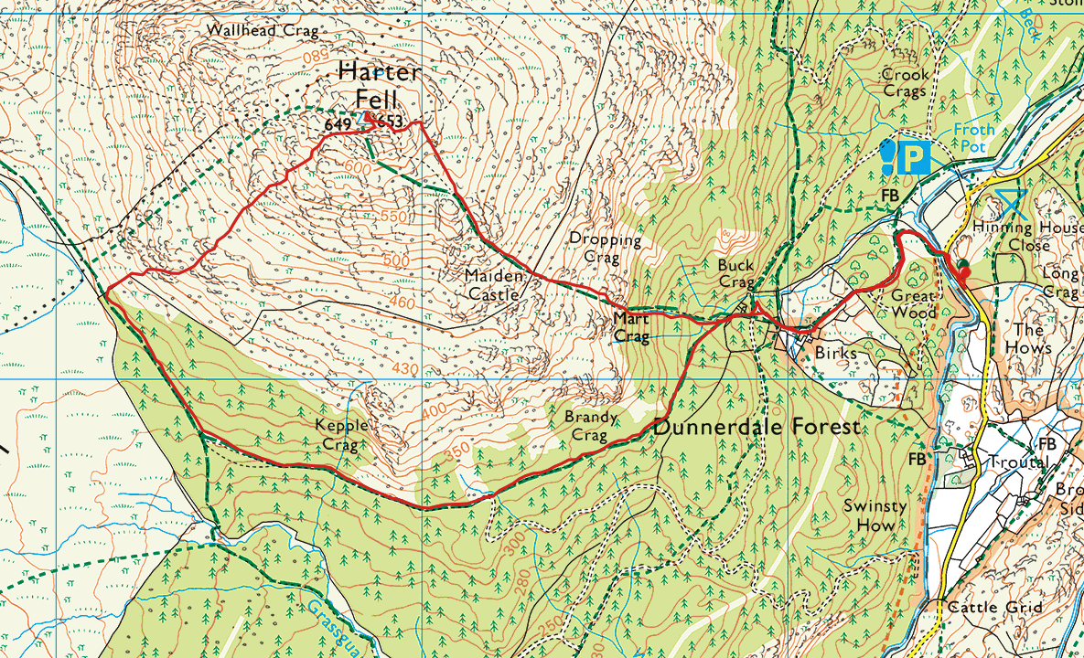
Distance: 3.9 miles     Total Ascent: 477 metres     Time Taken: 2 hours 15 minutes     Start Time: 09:30

Weather: Warm and hazy. 24C

The warm weather has continued for a couple of weeks in Cumbria and the Lakes and this was a fantastic opportunity to get out for a walk to local Harter fell and then have a dip in the River Duddon at the end of the walk – the perfect icing on the cake!

Screen Shot 2016-06-10 at 17.07.40

610_3677

Beautiful Birks Bridge at the start of the walk - perhaps I will pay a visit at then to those inviting cool, clear waters.

610_3680

Approaching Birks.

610_3682

Looking along the Duddon Valley from Birks, Bowfell and Little Stand in view.

610_3684

Grey Friar from the steep climb, Birks visible centre right.

610_3694

Hot dogs! Good job they have had a new haircut in this heat.

610_3695

Harter Fell summit.

610_3697

Harter Fell true summit from the official.

610_3698

Looking across to Green Crag, Devoke Water just about visible beyond.

610_3700

The Scafells and Upper Eskdale from Harter Fell, Hard Knott and the Roman fort in the centre ground.

610_3701

Descending the south-western slopes of Harter Fell, Green Crag and Crook Crag across the way.

610_3705

The forest road back to the start - and yes, we did enjoy a dip in the River Duddon at the end!

Kentmere Horseshoe

Walked on 24/06/2003

Kentmere – Garburn Pass – Yoke (53) – Ill Bell (54) – Froswick (55) – Mardale Ill Bell (56) – Harter Fell (Mardale) (57) – Kentmere Pike (58) – Shipman Knotts (59) – Kentmere

013.JPG

Thornthwaite, Ill Bell and Yoke from the Garburn road.

014.JPG

Cairn on Yoke.

015.JPG

Ill Bell from Yoke.

016.JPG

Windermere from Ill Bell, Troutbeck Tongue in the centre, Wansfell to the right.

017.JPG

Thornthwaite Crag from Froswick summit.

018.JPG

Kentmere Reservoir.

019.JPG

Windermere from Froswick.

020.JPG

Wild ponies on Thornthwaite.

021.JPG

Mardale Ill Bell summit, Haweswater Reservoir behind.

022.JPG

Small Water and the southern end of Haweswater Reservoir from Mardale Ill Bell.

023.JPG

The Nan Bield Pass - Mardale or Kentmere?

024.JPG

Harter Fell summit.

025.JPG

Kentmere Pike summit.

026.JPG

Shipman Knotts summit looking over to Yoke and Ill Bell.

Walking Diary

  • Pike o’ Blisco 28/11/2023
  • Blencathra 25/11/2023
  • Middle Fell & Seatallan 17/11/2023
  • Coniston Old Man 11/11/2023
  • The Mosedale Horseshoe 01/03/2022

Social

  • Facebook
  • Twitter

Information

  • Striding Edge
  • T&C’s
  • Privacy
  • Links