Height: 428 metres / 1404 feet Grid reference: NY 30018 01707
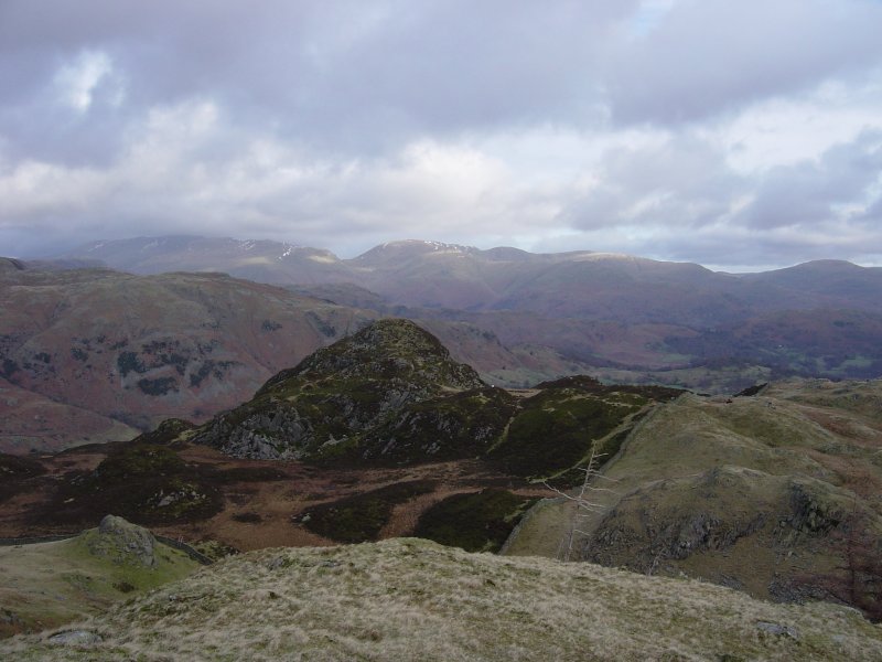
Great Intake from High Fell, with Red Screes and Caudale Moor behind
Height: 428 metres / 1404 feet Grid reference: NY 30018 01707
Great Intake from High Fell, with Red Screes and Caudale Moor behind
Start point: Tilberthwaite car park (NY 306 010)
Tilberthwaite – High Fell – Blake Rigg – Wetherlam Edge – Wetherlam – Steel Edge – Tilberthwaite Gill – Tilberthwaite
Distance: 4.6 miles Total Ascent: 918 metres Time Taken: 2 hours 5 minutes
Weather: Sunny with broken cloud. 12-14oC.
The sun was shining at times again this morning but many of the higher fells still had cloud lingering on their tops, fortunately for me Wetherlam remained relatively clear. This is a great little route from Tilberthwaite – it was almost reminiscent of a mini-Helvellyn ascent via Striding Edge and Swirral Edge – using Wetherlam Edge for the steep climb up and Steel Edge for the drop back down into Tilberthwaite.

Wetherlam route map.

3D image of the walk route.

Tilberthwaite.

The Langdale Pikes from High Fell. Pike O' Blisco is on the far left, Blea Tarn is to the centre right.

Wetherlam from Blake Rigg.

A panoramic view of Wetherlam.

Looking back along Wetherlam Edge with Little Langdale Tarn to the left.

Windermere.

The Old Man of Coniston from Wetherlam. The Coniston fells remained in cloud all morning.

Wetherlam summit.

Looking across Wetherlam Edge to a distant Dunmail Raise.

Coniston Water.

Steel Edge, the route used in descent.

Tilberthwaite Gill.
Start point: Tilberthwaite car park (NY 306 010)
Tilberthwaite – Tilberthwaite Gill – Blake Rigg (261) – Haystacks (Tilberthwaite) (262) – Hawk Rigg (263) – High Fell (264) – Great Intake on Low Fell (265) – Kitty Crag (266) – Long Crag on Yewdale Fells (267) – High Wythow (268) – Low Wythow (269) – Brackeny Crag (270) – Tilberthwaite
Weather: Cool and clear.
Today’s walk is a round of the Tilberthwaite Fells. Nestling between Coniston and Langdale and bearing the scars of an industrial past, this route with fells of small stature offers some excellent and surprising views.

Tilberthwaite Fells route map.

Elevation profile of the route. Key: BR=Blake Rigg, H=Haystacks (Tilberthwaite), HR=Hawk Rigg, HF=High Fell, GI=Great Intake, KC=Kitty Crag, LC=Long Crag, HW=High Wythow, LW=Low Wythow, BF=Brackeny Fell

High Tilberthwaite Farm.

Wetherlam from Blake Rigg.

The Langdale Pikes from Haystacks (the Tilberthwaite one!).

Haystacks and Blake Rigg from Hawk Rigg.

Red Screes and Caudale Moor flank the Kirkstone Pass in the centre distance, the near hummock is Great Intake from High Fell.

The Langdale Pikes and Blea Tarn from Great Intake.

Looking across to Pike O' Blisco and The Crinkle Crags - annotated.

Looking across to Pike O' Blisco and The Crinkle Crags.

Crossing and un-named beck above Tilberthwaite Gill, Wetherlam is behind.

Looking back to the sunlit Tilberthwaite Fells.

Hole Tarn.

Levers Hawse and the Brim Fell - Swirl How ridge from Kitty Crag.

Kitty Crag and the Coniston fells from Long Crag.

Windermere and the eastern fells from High Wythow.

The full length of Coniston Water can be seen from Low Wythow.

The south face of Wetherlam from Brackeny Crag.