Height: 526 metres / 1726 feet Grid reference: NY 18700 16897
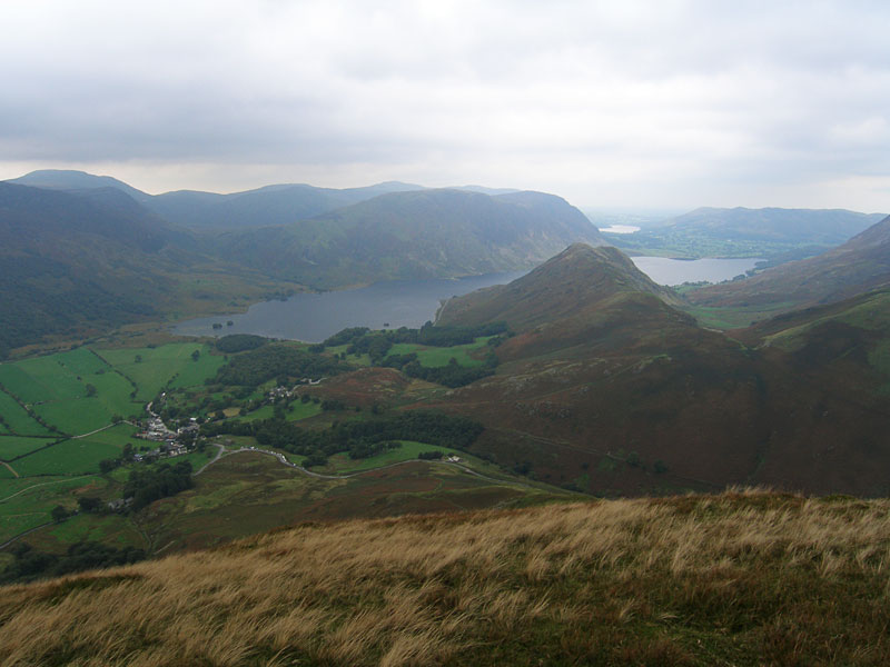
Buttermere village and Crummock Water from High Snockrigg
Height: 526 metres / 1726 feet Grid reference: NY 18700 16897
Buttermere village and Crummock Water from High Snockrigg
Start Point: Buttermere (NY 176 170)
Buttermere – Hassness – Robinson – High Snockrigg – Buttermere
Distance: 4.3 miles Total Ascent: 700 metres Time Taken: 3 hours Start Time: 08:30
Weather: Long sunny spells, 11°C
Today’s walk was from Buttermere up to Robinson the steep way from Hassness. The weather was changeable though there were long sunny spells. Once on the top of Robinson the cloud closed in and it was back to hat and gloves in the cold wind.

Buttermere was very quiet this early in the morning.

No cars and no people around by the church.

Walking the lakeshore path.

High Stile.

The rock tunnel.

Climbing above Hassness, looking across to Pike.

High Stile feels close enough to touch from here.

A lovely view.

Similar, but higher up.

Goat Gills.

The clouds were on and off the western fells.

This path is steep!

From Wainwright's The North Western Fells, Robinson 8: 'A young rowan has secured a precarious foothold on this crag. Can it survive? Will some kind reader write to the author in 1970 and say it is still alive and well?'. In the 2008 Jesty updated version, it was stated as still there and now known as 'Wainwright's Rowan'.

Fleetwith Pike in black and white.

Haystacks.

High Crag and Stile.

Flatter ground on the way to the summit.

Sunshine on Honister Pass.

There wasn't much of a view when I got to the summit!

Mountain dog views Crummock Water and Loweswater.

Knott Rigg in the sunshine.

Robinson from High Snockrigg.

Dougal, ready for action!

Whiteless Pike.

The sun is out...now!
Start point: Rigg Beck (disused quarry) (NY 229 201)
Rigg Beck quarry – Gillbrow – Little Dale – Robinson – High Snockrigg – Newlands Hause – Knott Rigg – Ill Crag – Ard Crags – Rigg Beck quarry
Distance: 8.1 miles Total Ascent: 953 metres Time Taken: 4 hours
Weather: Hot, humid and hazy. 25C.
The recent humid weather continued today and the views were very hazy until the sun managed to burn through towards the end of the walk. I think Casper was feeling the heat today, so much so that he was nearly tripping over that tongue of his. Mind you, I was nearly tripping over mine too – phew, it was too hot to walk!

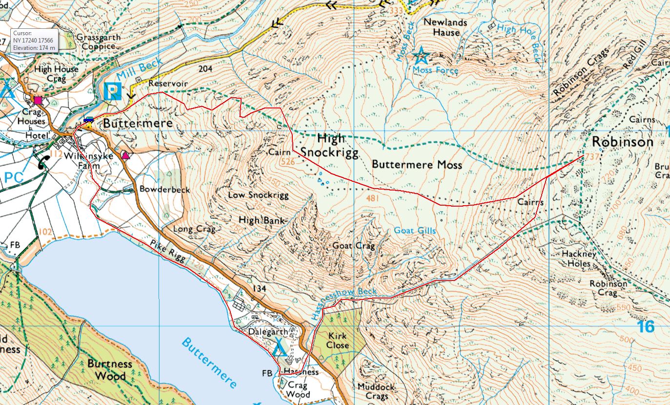
Robinson route map.

Hazy Robinson and High Snab Bank from Birkrigg. All today's early views were very hazy until the sun managed to burn through. It was, though, very muggy and close and it made the climb to Robinson hard going.

A view across the Newlands Valley to Catbells.

Scope Beck along the valley. The way to High Snab Bank is straight up to the right adjacent to the wall but I fancied a change today so headed straight along the valley towards the reservoir at its head.

Walking alongside Scope Beck.

Looking back towards Catbells.

Falls on Scope Beck.

Scope Beck.

Robinson (and Crusoe!).

Deep Gill and the reservoir. The path zig zags up to the right of the gill.

Reservoir reflections.

Climbing toward Little Dale, looking back over the reservoir.

Hindscarth from the plateau of Little Dale.

Newlands view, back up on the main path from High Snab Bank now.

The summit of Robinson.

It was tough work that Casper, I thought I had a steam train following me today with all that panting going on. You can see that Casper is starting to turn slate now around the eyes. Don't worry Casper, that happened to me years ago.

The descent to High Snockrigg, High Stile and Red Pike across Buttermere. It was spotting with rain now and there were rumbles of thunder around.

Oddly enough the skies were starting to clear a bit too.

Sunlight on Rannerdale Knotts, Crummock Water and Mellbreak beyond from High Snockrigg.

A silhouetted fell view from High Snockrigg.

Haystacks, High Crag and High Stile across Buttermere.

He's heard something...

...it's the sound of the families below at Newlands Hause. We are crossing straight over to climb Knott Rigg.

Knott Rigg and Ard Crags this way.

High Snockrigg over Newlands Hause from the climb to Knott Rigg. They breed their horse flies big over here and the place was completely infested with them - time to try out the secret insect repellent available from Love the Lakes!

Oh, this was a long section without any water - eh, Casper?

Heading for Ard Crags from Knott Rigg.

Following the ridge.

Behind, the weather was clearing looking back to Knott Rigg with Keskadale Edge to the left.

Casper enjoys the sun on Ard Crags with Wandope, Eel Crags and Sail in view.

A beautiful day now looking back to Aiken Knott.

The view from the crossing of Rigg Beck. It was so warm now, I joined Casper in here - first I had a paddle as it was not so deep before lying down fully clothed. Heaven.
Start point: Chapel Bridge, Little Town (NY 232 194)
Little Town – High Snab Bank – Robinson (487) – High Snockrigg (488) – Newlands Hause – Knott Rigg (489) – Ill Crag (490) – Ard Crags (491) – Chapel Bridge – Little Town
Distance: 10.5 miles Total Ascent: 950 metres Time Taken: 4 hours 30 minutes
Weather: Overcast. 16oC.
I wasn’t holding out much hope for the weather today as it was very grey and looked a certainty for rain – as it was I thought we faired pretty well as the rain held off for the whole round. This is a great way to reach the summit of Robinson and the views were good from there, even the high winds couldn’t spoil that.


Scope End, left, with Robinson on the right. High Snab Bank, the ridge used in ascent can be seen in the foreground of Robinson.

Newlands Church.

Robinson and High Snab Bank, High Snab is the farm building to the right.

Little Dale and Robinson from the steep climb up to High Snab Bank.

Wandope, Crag Hill and Sail behind Ard Crags (to be climbed on the return leg) above Keskadale Farm.

Casper has a rest on High Snab Bank - that was a steep climb!

Robinson ahead from High Snab Bank.

Hindscarth above Little Dale.

Robinson from Blea Crags.

Derwent Water, Cat Bells, Maiden Moor and Scope End from Robinson.

Deep Gill and Littledale Edge.

Angus and Casper on the summit of Robinson.

Crummock Water and Rannerdale Knotts with Mellbreak and Loweswater beyond.

High Crag and High Stile in and out of the mist across Buttermere.

Grasmoor and Crag Hill beyond Whiteless Pike and Wandope.

Looking across Buttermere Common to High Snockrigg.

Buttermere village below with Mellbreak and Loweswater beyond Crummock Water and Rannerdale Knotts.

It was windy on High Snockrigg...

...very windy!

Knott Rigg across Newlands Hause.

Moss Force.

The waterfall from further up.

Crag Hill and Sail from Ill Crag.

Ard Crags ahead.

The sun shines on the Newlands Valley and Catbells.

Hindscarth and Robinson from Ard Crags.

The same view from further along the valley.

Robinson.