Height: 395 metres / 1296 feet Grid reference: NY 14343 02610
Whin Rigg from the summit of Irton Fell
Height: 395 metres / 1296 feet Grid reference: NY 14343 02610
Whin Rigg from the summit of Irton Fell
Start Point: Miterdale (NY 146 011)
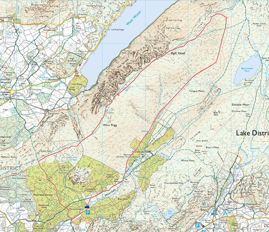
Miterdale – Irton Fell – Whin Rigg – Illgill Head – Robin Gill – Miterdale
Distance: 8.7 miles Total Ascent: 728 metres Time Taken: 4 hours Start Time: 09:20
Weather: Overcast, clearing slowly, 15°C
Today’s walk was across the top of ‘The Screes’ over Whin Rigg and Illgill Head. There are great views from the edge of the screes across Wasdale but the valley walk on the return leg isn’t that great, it being very enclosed and the way I went was quite boggy. All the better for testing new boots then…

Han Wag Tatra's from Alex at The Keswick Boot Company (opposite Love the Lakes in Keswick). Top service from the main man - I will report back on their performance after a bit of use.

Fletcher will be with us soon, here he is playing with his sister (the brown one). He already looks full of mischief!

Sign at the start of the walk. The answer to the question is 'lots' by the look of it...

Miterdale Forest from the Irton Fell ridge. Lots of tree felling here, the photo below shows how it was in 2011 with the trees to the right of the photo. The photo above was taken at the middle point of the three tree sections.

Miterdale Forest in 2011

Whin Rigg from Irton Fell.

Greathall Gill.

Looking back to Muncaster Fell and the Ravenglass Estuary.

Whin Rigg.

Seatallan and Middle Fell across Wast Water.

Great Gully on Whin Rigg.

Standing on the edge.

A panorama of the way ahead.

Dougal decides the best way to get to the tarns with the clear path leading to Illgill Head.

Looking back to Whin Rigg, the mist swirling on and off the ridge.

Middle Fell.

Red Pike, Pillar, Yewbarrow, Kirk Fell and Great Gable all in view now.

Illgill Head summit.

Mono Wasdale.

Yewbarrow.

Dougal the sheep spotter.

Burnmoor Tarn, Eskdale Fell beyond. I descended via Robin Gill which turned out not to be the best way with hindsight - it is easier to descend to the east of Tongue Moor.

Crossing Little Grain Gill.

Looking back along Robin Gill.

This place will look different in a year or two with the amount of trees planted.

All around were carpets of Bluebells, a lovely sight.
Start point: Old Quarry car park (NY 121 012)
Old Quarry car park – Irton Pike (OF) – Irton Fell – Whin Rigg – Illgill Head – Burnmoor Tarn – Miterdale – Old Quarry car park
Distance: 11 miles Total Ascent: 745 metres Time Taken: 4 hours 30 minutes
Weather: Sunny with a cool wind on the tops. 10°C.
It turned out to be a really sunny day today, the early clouds soon cleared from the high fells and although there was a cold wind on the Whin Rigg – Illgill Head ridge, the walk back along Miterdale was in very Spring-like conditions. This is a lovely walk and Miterdale feels really remote; we didn’t see a soul today.


Early morning sunshine on Irton Pike. The way ahead is to Whin Rigg up to the right.

Whin Rigg.

Casper enjoys soaking up the sunshine on Irton Pike. This fell has now been completely denuded of trees on its southern slopes.

Looking back to Irton Pike from Irton Fell.

Whin Rigg ahead from Irton Fell.

Looking south to Irton Fell from the slopes of Whin Rigg with Muncaster Fell in the distance.

The view from the summit of Whin Rigg.

Casper with Yewbarrow, Kirk Fell and Great Gable in the distance.

Illgill Head from the edge of the screes.

The route to Illgill Head.

Yewbarrow across Wasdale - a fine fell.

Time for a dip in one of the tarns on the ridge.

Illgill Head.

Looking back to Whin Rigg.

Middle Fell and Seatallan across Wast Water.

The ridge between Whin Rigg and Illgill Head.

Angus and Casper on Illgill Head, behind are Great Gable, Lingmell and Scafell.

The head of Wasdale from Illgill Head.

Yewbarrow with Red Pike and Pillar behind.

Great Gable.

They're loving it!

Lingmell and Scafell.

Great Gable and Lingmell.

Scafell and Slight Side from the descent of Illgill Head.

Eskdale Fell across Burnmoor Tarn. Beyond is Slight Side with Burnmoor Lodge to the right of the tarn.

The same view from the path into Miterdale.

Scafell, Slight Side, Eskdale Fell and Burnmoor Tarn from Miterdale.

Scafell at the head of remote and quiet Miterdale.
Start point: Old Quarry car park (NY 121 012)
Old Quarry car park – Irton Pike (OF) – Irton Fell – Whin Rigg (445) – Illgill Head (446) – Burnmoor Tarn – Miterdale – Old Quarry car park
Distance: 11 miles Total Ascent: 900 metres Time Taken: 4 hours
Weather: Grey to start, ever brightening. 7°C
It started off a bit grey and murky this morning, but at least it wasn’t raining after the downpour yesterday which left many places waterlogged and boggy. These fells overlooking Wast Water are perhaps better known from the side as ‘The Screes’, where the steep and treacherous western face looks almost insurmountable. The contrasting eastern side falling to Miterdale is quite gentle and grassy and this is the route I took for the return leg after the ridge walk above Wast Waster.


The sun shines on Sellafield and the West Cumbrian coast from Irton Pike.

Wast Water and Wasdale from Irton Pike. The way ahead is the ridge running to the right above Wast Water.

The path to Whin Rigg from Irton Fell.

Greathall Gill - a great slice cut out of the fellside.

Looking back along the path, over Greathall Gill to Irton Fell and a sunlit Irton Pike.

Contemplation on Whin Rigg for Angus.

Middle Fell over Wast Water from Whin Rigg.

A glimpse of Wast Water down Great Gully.

Something has caught his eye.

Illgill Head in mist over the tarns.

Mountain tarns - they are a great place...

...for a swim.

There are plenty up here.

Looking over to Yewbarrow.

Scary scree slopes.

Middle Fell and Yewbarrow over Wast Water.

The jagged edge of Whin Rigg.

A dull looking Wasdale Head with Kirk Fell and Great Gable in the mist.

Burnmoor Tarn - note the isolated Burnmoor Lodge to the right of the photo.

The sunrays burst out over Miterdale.

A nice place to live.

Sunshine and blue skies now on Whin Rigg.

Great Grain Gill.

Cascades on the River Mite.

Further along the river.

You need to think in the local dialect to translate this sign.
Start point: Old Quarry car park (NY 121 012)
Old Quarry car park – Irton Pike (OF) – Irton Fell (271) – Great Bank (272) – Old Quarry car park
Weather: Cool and clear.
I’m under doctor’s orders today but exercise was recommended so it had to be an easy walk taken at a gentle pace. The Irton Pike/Irton Fell route was ideal as it gives great views of the high fells without being too strenuous. There were still many trees lying around in the Miterdale Forest and the surrounding woods having been blown over by the recent high winds.

Irton Pike route map.

Elevation profile of the route. Key: IP=Irton Pike, IF=Irton Fell, GB=Great Bank.

3D image of the walk route.

Illgill Head and Miterdale Forest from the ascent of Irton Pike. Great Bank shows above the trees to the right of the photo.

Wasdale Head from Irton Pike - annotated.

Wasdale Head from Irton Pike.


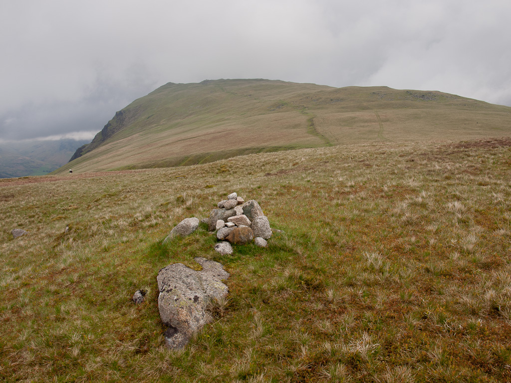
Wainwright wrote '...a massive heap of stones calls for investigation...'. This pile of stones is marked on the map as 'cairn circle' and lies between Irton Pike and Irton Fell. The Ravenglass Estuary can be seen above it with Irton Pike to the right.

Another view of the River Mite entering the Ravenglass Estuary from higher up. The path looks down to Irton Pike, Muncaster Fell is to the left.

Whin Rigg from the summit of Irton Fell, Yewbarrow is to the left. I was tempted....

Harter Fell and Green Crag across Eskdale.

Muncaster Fell from Great Bank.

The rocky south face of Great Bank.

There is still much evidence of the devastation caused by the recent high winds.