Height: 354 metres / 1161 feet Grid reference: NY 07378 11418
Latter Barrow
Height: 354 metres / 1161 feet Grid reference: NY 07378 11418
Latter Barrow
Start point: Cold Fell road (NY 060 138)
Cold Fell Road – Blakeley Raise (127) – Grike (128) – Crag Fell (129) – Whoap (130) – Lank Rigg (131) – Kinniside (132) – Latter Barrow (133) – Swarth Fell (Kinniside) (134) – Burn Edge (135) – Cold Fell Road
Weather: Rain.
Another muggy, overcast day today and a walk where solitude is virtually guaranteed on the western fringe of the Lake District – a round of the Lank Rigg group of fells.
The walk starts from The Cold Fell road where there are plenty of verge parking places available. I made a direct ascent from the road up the grassy slope of Blakely Raise.


Grike from Blakely Raise summit. From the summit, I followed the fence down to a sheep intake and a gate which had to be climbed as it would not open and onto the main forest road. Following the road to a gate on the left, it was then up more grassy slopes to the summit of Grike, stepping over a wire fence en-route.

Crag Fell and Great Borne from the summit of Grike. An easy descent past a weather station and then a simple climb took me to the summit of Crag Fell with Ennerdale Water below and silhouettes of Pillar, Scoat Fell and Haycock visible through the murk.

Herdus and Great Borne with Starling Dodd to the right across Ennerdale Water from Crag Fell.

Looking to the head of Ennerdale Water from Crag Fell, the High Stile ridge to the left and Pillar just visible on the right. I followed the track down another easy descent to a forest fire break, through the break and over a stile to the stone wall of the Ennerdale Fence. This wall continues for many miles over many summits.

The Ennerdale Fence. I followed the fence until the first gate and then swung right to ascend another grassy slope, Whoap.

Lank Rigg from the stone marking the summit of Whoap. From Whoap, another descent to a dip and then steeply up to the summit Lank Rigg, the high point of this round.

Whoap from the summit of Lank Rigg. From here, I passed an un-named summit tarn and then descended past an ancient cairn on a grassy track between the rocks. Across the very wet Poukes Moss to an un-named grassy mound on O.S maps - Birkett has christened it Kinniside.

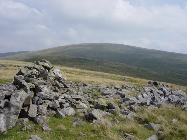
Latter Barrow from the summit cairn on Kinniside. From here it's an easy traverse to Latter Barrow, clearly visible ahead.

Kinniside and Lank Rigg from Latter Barrow. From Latter Barrow, I had a steep descent to the River Calder, decisions-decisions on the best place to cross and then steeply up the bracken slopes to Swarth Fell. For this part of the journey I was accompanied by a buzzard soaring overhead - I'm not sure if he thought I was on my last legs...

Crossing the River Calder

and a buzzard circles overhead

Lank Rigg, Kinniside and Latter Barrow from the summit cairn of Swarth Fell. From Swarth Fell it is an easy descent to Burn Edge, the summit is marked with scattered stones. From here, all the fells of the completed round can be seen - a great viewpoint.

Crag Fell and Whoap from Burn Edge. From Burn Edge, the grassy shoulder leads directly down to the road and the start point of the walk.