Height: 681 metres / 2234 feet Grid reference: NY 46894 09448
Little Harter Fell
Height: 681 metres / 2234 feet Grid reference: NY 46894 09448
Little Harter Fell
Start point: Mardale Head (NY 469 127)
Mardale Head – Hollow Stone – Branstree north ridge – Artlecrag Pike – Branstree – Gatescarth Pass – Little Harter Fell – Harter Fell (Mardale) – Nan Bield Pass – Mardale Ill Bell – High Street – Rough Crag (Riggindale) – Mardale Head
Distance: 8.2 miles Total Ascent: 960 metres Time Taken: 4 hours
Weather: Sunny and bright, becoming cloudy. 10oC.
It was sunny and bright first thing this morning with hardly a cloud in the sky – fantastic conditions for a walk around Mardale Head. Once up to High Street, the clouds came in and made it all a bit flat and I felt in hindsight it might have been better walking anti-clockwise…but then again, who knows? You never can tell what the weather will do.


It's a lovely morning with sun shining at the head of Mardale.

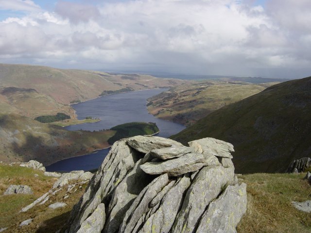
The route from the road up to the north ridge of Branstree is certainly initially steep and direct. There is a great view over Haweswater into Riggindale, the rock in the foreground being the Hollow Stone.

Kidsty Pike above Riggindale.

The head of Riggindale.

Kidsty Pike and Kidsty Howes.

High Street with a touch of snow on top from the old sheepfold.

Selside Pike from the north ridge.

Looking north east from Artlecrag Pike.

The view to the west from the same place.

The summit of Branstree with a hot air balloon over Harter Fell.

Harter Fell from the descent of Branstree. The path used in ascent across Gatescarth Pass can be seen starting from the mid-left.

Looking back to Branstree.

The path to Harter Fell.

Casper Wainwright (see Harter Fell 10, The Far Eastern Fells below). The benchmark in the Wainwright self-portrait can be seen on the rock in the photo. All you need now is a pipe Casper!


High Street and Small Water from Harter Fell.

The summit of Harter Fell.

Mardale Ill Bell and High Street.

Descending to Nan Bield Pass.

Yoke, Ill Bell and Froswick above Kentmere Reservoir.

Harter Fell from Nan Bield pass.

Looking back to Harter fell from the climb to Mardale Ill Bell.

Small Water and Haweswater.

High Street from Mardale Ill Bell.

Casper on Mardale Ill Bell.

Once on High Street, it started to cloud over. This view is to the western fells with the Scafells and Great Gable in the distance and Helvellyn mid distance on the right. That's an icy looking puddle!

Helvellyn from High Street.

The wall on High Street.

The flat top of Harter Fell from High Street.

Long Stile and Rough Crag, the route of descent.

Blea Water from the snowy eastern edge of High Street.

Long Stile.

It has completely clouded over now looking back to High Street and Long Stile over Caspel Gate Tarn from Caspel Gate.

High Street from Rough Crag.

Colourful trees on The Rigg looking along Haweswater.

Haweswater.

Autumn on The Rigg.

Orange grass crossing Mardale Beck.
Start point: Mardale Head (NY 469 127)
Mardale Head – Gatescarth Pass – Adam Seat (1) – Little Harter Fell (2) – Harter Fell (Mardale) (3) – Nan Bield Pass – Mardale Ill Bell (4) – High Street (5) – Rough Crag (Riggindale) (6) – Rampsgill Head (7) – Kidsty Pike (8) – Mardale Head
Weather: Sunny with snow and hail showers.
This is the start of my quest to climb the 541 Birkett Fells!


Haweswater from Mardale Head...

and Gatescarth Beck.

The Boundary Stone at the summit of Adam Seat, 'L' on one side

'H' on the other (Longsleddale and Haweswater).

Haweswater from the summit of Little Harter Fell. (Compare AW The Far Eastern Fells - Harter Fell 10).

Harter Fell summit in a snow shower.

Kentmere

A rainbow over Small Water ('the finest of Lakeland's tarns), from the descent to Nan Bield Pass.

Mardale Ill Bell summit with Yoke, Froswick and Ill bell in the background.

Two views of High Street summit.


Rough Crag and Haweswater from High Street. The area around the small tarn is called Caspel Gate.

Harter Fell and the Nan Bield Pass from Rough Crag summit, Small Water is just visible.

Hayeswater and the distant Patterdale Fells from the Roman Road.

The mist swirls across High Street on the walk to Rampsgill Head.

Looking North from Rampsgill Head's summit. The Nab is to the left with Hallin Fell in the centre adjoining Steel Knotts. Ullswater is just visible right of centre.

High Street from Kidsty Pike summit.

The sun shines on Riggindale and Rough Crag.

A long meander of Riggindale Beck...

and the ruins of Riggindale Farm.

The Mardale Skyline.