Height: 883 metres / 2897 feet Grid reference: NY 34277 17414 Category: The Eastern Fells
The frozen summit of Raise
Height: 883 metres / 2897 feet Grid reference: NY 34277 17414 Category: The Eastern Fells
The frozen summit of Raise
Start point: Glenridding (NY 382 169)
Glenridding – Glenridding Dodd – Heron Pike (Glenridding) – Sheffield Pike – Nick Head – Glencoyne Head – Hart Side – White Stones on Green Side – Stybarrow Dodd – Sticks Pass – Raise – White Side – East Ridge – Keppel Cove – Greenside Road – Glenridding
Distance: 9.6 miles Total Ascent: 1082 metres Time Taken: 4 hours 30 minutes Start Time: 07:15
Weather: Long sunny spells. 14°C
The fells to the east seemed to enjoy the best of the weather today and it was lovely and sunny for most of today’s walk to some of the eastern fells I haven’t visited for a while. It was like a summers day walking back along Glenridding, never mind spring and I think I caught the sun today as well. Time to ditch the micro spikes and get out the sun cream and shorts I reckon!

Raise route map.

Sunshine at the foot of The Rake.

Climbing The Rake to Glenridding Dodd.

Raise at the head of Glenridding.

Looking across to Birkhouse Moor.

Birks and St. Sunday across Gillside.

The summit of Glenridding Dodd.

Ullswater from the eastern cairn.

It's lovely and clear in Glenridding.

Boundary Stone on Heron Pike. 'M' for Marshall estate of Patterdale with 'H' on the other side for Howard estate of Greystoke.

First sight of Helvellyn with snow cornice still evident and Catstycam.

Catstycam reflected.

It was beautiful to the east but there was a cold wind once up onto the Sheffield Pike ridge.

It looks like Ullswater carries on from the ridge here,.

A closer view of Ullswater, Glencoyne below.

Inscribed stone on the summit.

The summit of Sheffield Pike.

Dougal and Casper enjoying the sunshine on the summit.

...and lying by 'the pool'!

Yet another boundary marker, 'M 1912', heading for Glencoyne Head.

Casper's going the wrong way looking to Raise across the old lead mines.

In a hurry to get across to Hart Side.

Stybarrow Dodd complete with stubborn snow patches from Hart Side.

Looking back to the train from Hart Side on the way to White Stones.

Stybarrow Dodd from White Stones and it seems to be a lot cloudier over to the west, in fact I would say the Helvellyn ridge was the dividing line between sunshine and cloud today.

Hart Crag on the left and White Stones on the right from the climb to Stybarrow Dodd.

Great Dodd from Stybarrow Dodd.

Climbing to Raise looking back across Sticks Pass to Stybarrow Dodd.

The summit of Raise.

Looking west from Raise, Great Gable is central.

An odd photo but Skiddaw looked like a volcano with a giant sheet of cloud seemingly emanating from its summit.

All was dull on White Side.

I descended by this steep cut on the east side of White Side. I did wonder if anyone had ever been down here before but it certainly was a quick way down.

White Side from Keppel Cove.

Breached in 1931 and never repaired - the dam in Keppel Cove.

Sheffield Pike from the sunny walk back along Glenridding. In the shelter of the valley it was boiling hot, like summer!

Swart Beck and the disused mine workings.
Start point: Lay by opposite Swirls Car Park (NY 315 170)
Swirls – Browncove Crags – Helvellyn – Helvellyn Lower Man – White Side – Raise – Swirls
Distance: 6.3 miles Total Ascent: 920 metres Time Taken: 4 hours
Weather: Cold and clear with temperature inversion. 5°C
It ended up being a day of two halves with the weather, but I really couldn’t have expected anything better than the cold and clear weather complete with a temperature inversion that covered the whole of the south Lakes that I managed to see from the summit of Helvellyn. Later the inversion lifted and completely enveloped me making it a completely different walk during the latter stages.

Helvellyn route map.

Sunlight on Blencathra along St John's in the Vale.

As soon as the snowline was reached it was time for the crampons as everything was iced over making the going slippery. This is the view from where I put them on and all is clear to the north over Skiddaw and Blencathra.

Looking across Thirlmere to the western fells.

White Side from the climb to Browncove Crags.

Ice axe definitely required for this steep section to Browncove Crags.

Finally up into the sunshine and the first view of a big inversion to the south.

Great Gable is clear towards the left but there is cloud forming now on some of the other fells around it.

Climbing higher - can't wait to get to the top.

Stybarrow Dodd, Raise and White Side. Blencathra in the left distance has a covering of cloud now.

The mist clearing from Helvellyn.

The view to the south west...

...and the contrasting view to the north west.

All clear now on Helvellyn.

It was a fantastic day to be on the fells today.

Casper living on the edge.

Swirral Edge, Catstycam with Ullswater beyond.

The Edges and Red Tarn from the summit of Helvellyn.

Swirral Edge.

The icy trig. column on Helvellyn.

The southern half of the Lake District is completely covered in cloud today.

Not many people around today.

In fact I am on my own now, here looking at the snow corniced edge of Helvellyn.

Looking to Nethermost Pike and Dollywaggon Pike.

Swirral Edge and Catstycam with Raise distant left - that's the way I am going today.

Frozen boulders and the cross shelter with Fairfield beyond.

The Master of the Universe.

Not much chance of getting a seat in the cross shelter today, it is 'full'.

The mighty Striding Edge.

The half buried Gough Memorial.

Beautiful sunshine, beautiful inversion, beautiful snow.

Casper in the winter wonderland.

Helvellyn.

A final view to the south as I head across the summit to Helvellyn Lower Man.

A 360 degree panorama from Helvellyn.

White Side and Raise from Helvellyn Lower Man.

The mist was starting to form in the Thirlmere Valley below, in fact it felt as though the inversion was moving towards me from the north and west.

The cloud starts to pour over Browncove Crags.

Still clear over Brown Cove to Sheffield Pike and Ullswater, Catstycam to the right.

White Side and Raise from the descent of Lower Man.

Swirral Edge.

It's all catching me up now.

The cloud is now pouring across Helvellyn and engulfing Swirral Edge.

I've a feeling it is going to get me pretty soon.

It certainly did! A glimmer of winter sun on White Side.

A skier on Raise.

Raise summit.

Descending from Raise the weather had completely changed and it was now a rather dull day.

A brief glimmer of blue sky once ,more on the final descent.
Start point: Glenridding car park (NY 385 169)
Glenridding – Glenridding Dodd – Heron Pike (Glenridding) – Sheffield Pike – Nick Head – White Stones on Green Side – Stybarrow Dodd –Sticks Pass – Raise – White Side – Greenside Road – Glenridding
Distance: 8.8 miles Total Ascent: 1037 metres Time Taken: 3 hours 35 minutes
Weather: Clear above clouds, very cold wind. 4oC.
I wasn’t expecting much from today’s walk as it was dull in Glenridding and the high fells looked to be under cloud for the day. I knew it would be cold though as there was a fair old wind whistling around Glenridding village. It was cold enough on Fairfield on Tuesday but this was a lot colder – almost like winter!


Raise at the head of Glenridding from the climb to Glenridding Dodd.

Birkhouse Moor.

Sunrays over Glenridding.

It's all a bit dull down here - Ullswater from Glenridding Dodd.

It looks a bit brighter over Sheffield Pike though.

A frozen pool on the way to Sheffield Pike up to the right with White Stones and Stybarrow Dodd to the left. The wind was really cold and biting here.

The weather was changing constantly, almost by the minute, with the strong wind blowing mist across the fells alternating with bright sunshine. Helvellyn and Catstycam remained under a thick blanket of cloud throughout the walk.

Watermillock Common and Great Mell Fell from the summit of Sheffield Pike. 'H' is the boundary marker for the Howard Estate of Greystoke, the other side is marked with 'M' for the Marshall Estate of Patterdale.

Raise, in and out of the swirling mist.

White Stones and Stybarrow Dodd was getting the same treatment.

A clear spell on the climb to White Stones.

White Stones.

Stybarrow Dodd from White Stones.

Heading for Stybarrow Dodd.

Looking back to White Stones and Hart Side.

Into the freezing mist on the summit of Stybarrow Dodd.

Two minutes after we left the summit, it cleared!

Dramatic clouds over Glenridding.

Looking across Sticks Pass to Raise, now submerged under cloud cover.

Cloud clear of the summit of Stybarrow Dodd again, Stanahgill Head to the left remains filled with it.

A Brocken spectre on Stybarrow Dodd.

On the descent to Sticks Pass looking to Sheffield Pike.

That's it, I could stand it no more. Time for the full polar expedition gear to come out - it really was that cold! To the left is Great Gable and Kirk Fell, Pillar covered in cloud and round to the north-western fells across a sea of cloud from Sticks Pass.

Low sun and biting cold on the climb to Raise.

The south-western cairn on Raise from the summit.

Casper braves the oh-so-cold wind.

Skiddaw from Raise, Blencathra covered by cloud to the right.

..and closer up.

Stybarrow Dodd, Watson's Dodd and Great Dodd over Sticks Pass.

...and closer up.

The view to the west from Raise.

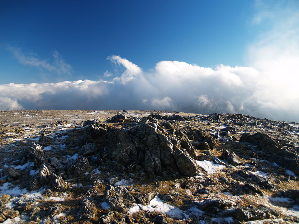
The frozen summit of Raise.

Closer up to the west.

White Side from the descent from Raise. That big cloud above was one of many which came crashing over us like waves descending from Helvellyn and engulfing White Side and Raise.

Lovely clear views across the clouds - when it clears from these tops.

The cloud clears briefly, and I mean very briefly from the frozen summit of White Side, here looking back to Raise and the Dodds.

Back into Glenridding valley it was like being in a different world. A lot calmer and a lot duller for the trek back to Glenridding. Looking back to Raise it appeared as if the whole fell was under cloud cover. Who could have guessed the secret weather that lay above?
Start point: Glenridding car park (NY 385 169)
Glenridding – Glenridding Dodd (199) – Heron Pike (Glenridding) (200) – Sheffield Pike (201) – Sticks Pass – Raise (202) – White Side (203) – Helvellyn Lower Man (204) – Helvellyn – Swirral Edge – Catstycam – Glenridding
Weather: Cloudy.
Today’s walk takes in a circuit of the Eastern Fells with a high point of Helvellyn. The weather wasn’t the best but a temperature inversion was always threatened but didn’t quite materialise, although there were some interesting views from Helvellyn.


Looking along Glenridding Screes to Raise from the steep climb up to Glenridding Dodd.

Ullswater and Gowbarrow Park from the summit of Glenridding Dodd.

View from the climb to Heron Pike; Ullswater and Glenridding Dodd with Place Fell behind on the right.

The iron marker post that marks the summit of Heron Pike. The 'M' marks the boundary of the Marshall estate of Patterdale, the reverse is marked 'H 1912' and marks the boundary of the Howard estate of Greystoke.

Waterfall on Sticks Gill.

Catstycam through the mist from White Side.

Looking along Glenridding Common to Ullswater from Whiteside Bank.

The Crinkle Crags and Bow Fell from Helvellyn.

The westerly view from Helvellyn.

The fearsome fangs of Swirral Edge.

Catstycam - no view!

Old mine workings at Swart Beck.

Glenridding – Glenridding Dodd (107) – Heron Pike (Glenridding) – Sheffield Pike (108) – Glencoyne Head – Hart Side (109) – Stybarrow Dodd (110) – Sticks Pass – Raise (111) – White Side (112) – Greenside Road – Glenridding

Birks and Keldas from the ascent of Glenridding Dodd.

Raise from the climb to Glenridding Dodd.

The summit of Glenridding Dodd L-R: Birkhouse Moor, Catstycam, Helvellyn, White Side and Raise.

Ullswater from Glenridding Dodd.

Catstycam and the Helvellyn ridge.

Ullswater from Sheffield Pike summit.

Great Dodd from Hart Side summit.

High Seat and Bleaberry Fell from the summit of Stybarrow Dodd.

Raise from Sticks Pass.

The summit of Raise with Skiddaw in the distance.

White Side from Raise with Helvellyn Lower Man behind.

White Side summit looking across to Helvellyn.

The Greenburn Road. L-R: Sheffield Pike, Place Fell, Birkhouse Moor. In the far distance is the High Street ridge.

Kepplecove Tarn beneath Helvellyn.

Looking up Swart Beck and the disused mine workings from the bridge.