Height: 412 metres / 1352 feet Grid reference: NY 22411 18306
Rowling End – left, Swinside – centre and on the right Skelgill Bank leading from Derwent Water to Cat Bells from Scope End
Height: 412 metres / 1352 feet Grid reference: NY 22411 18306
Rowling End – left, Swinside – centre and on the right Skelgill Bank leading from Derwent Water to Cat Bells from Scope End
Start point: Hawes End (NY 247 212)
Hawes End – Skelgill Bank – Catbells – Maiden Moor – High Spy – Dale Head – Hindscarth – High Crags – Red Knott –Scope End – Little Town – Skelgill – Hawes End
Distance: 10 miles Total Ascent: 1066 metres Time Taken: 5 hours Start Time: 07:00
Weather: Sunny and clear. 10C
The weather turned out much better than I expected today. Driving through the Lake District early the early morning fog, I knew this was inversion weather – Coniston, Windermere, the Vale of Grasmere, St John’s in the Vale and the Vale of Keswick were all covered by a thick carpet of mist but I only made up my mind where to walk at the very last minute. It was a good decision too I think as the mist lifted as the sun rose and covered many of the fell tops. I never saw another soul today!

Newlands Round route map.

First sight of Skiddaw over the inversion and colourful trees.

Panoramic Derwent Water inversion.

Blencathra across the sea of fog.

The view from higher up and the Vale of Keswick is immersed under the fog.

Autumn view.

The cloud cap on Blencathra is beautifully lit up by the rising sun.

Looking across to the sun rising over Coledale.

Climbing higher.

Sunrise over Bleaberry Fell.

Beautiful colours in the sunshine.

Catbells ahead from Skelgill Bank.

On Skelgill Bank in the sunshine.

The whole of the Vale of Keswick is under cloud this morning.

Nearly there!

The summit of Catbells.

Dougal takes a look into Borrowdale, heading for Hause Gate.

Swinside and Dodd, Bassenthwaite Lake under mist.

Misty trees below.

Closing in.

Colours and Keswick.

Borrowdale sunrise.

Autumn.

Manesty Park.

Houses in the mist.


A view into Borrowdale from the climb to Maiden Moor, Castle Crag to the right.The sunrise has cleared the bulk of the mist from Derwent Water now.


Panoramic Derwent Water.


Blencathra reflections.

Looking back to Catbells from the climb to Maiden Moor.

The view across the Newlands Valley.

Hindscarth and Robinson from the summit of Maiden Moor.

High Spy.

Dougal and Casper on High Spy.

Looking towards Great Gable over Dale Head Tarn.

Dale Head.

Casper and the Newlands Valley.

Beyond the central ridge, Helvellyn is under a thick blanket of cloud.

On the summit of Dale Head and the wind was absolutely freezing up here. First time this season for the winter jacket and gloves.

The view towards Helvellyn from Dale Head.

Buttermere.

The High Stile ridge.

The summit of Hindscarth.

Hindscarth and Robinson from Scope End.

Dougal works out the homeward route.

Scope End.

Newlands Church.

Causey Pike and Rowling End.
Start point: Hawes End (NY 247 212)
Hawes End – Skelgill Bank – Catbells – Maiden Moor – High Spy – Dale Head – Hindscarth – High Crags – Red Knott – Scope End – Little Town – Skelgill – Hawes End
Distance: 10 miles Total Ascent: 1066 metres Time Taken: 5 hours
Weather: Cold, clear at first but later in mist. 5°C
I could not believe the difference between the south Lakes and the north today. Travelling over Dunmail Raise is was as if I was transported from the dull and dreary south to the bright and frosty north on a different day. The day promised much when I set off for Catbells from Hause End but a lot of the high fells ended up being covered in cloud after the sun rose. The views from Catbells, though, made getting out of bed that bit earlier today well worth it.

Dale Head Horseshoe route map.

The sunrise at the start of the walk from Hawes End. Derwent Water is covered in mist and the rising sun looks great on a cloud topped Skiddaw.

Looking west towards Causey Pike over Newlands all is cold and frosty.

Mist on Derwent Water and over Keswick.

Walla Crag and Bleaberry Fell across the water.

Climbing higher towards Catbells with the sun still on Skiddaw.

The mist is already starting to lift and showing some cloud reflections. Blencathra is cloud covered in the left distance.

What a view.

The rising sun on Grisedale Pike.

Catbells and Skelgill Bank.

A panoramic view from Skelgill Bank.

The view to Newlands Hause with Robinson left and Ard Crags right.

Swinside and Bassenthwaite Lake.

Skiddaw is clearing of cloud now.

Blencathra under cloud.

A cold and frosty climb towards Catbells.

Catbells ahead.

The frozen summit of Catbells looking towards Bassenthwaite Lake.

Casper finds it hair raising this morning.

Heading for Maiden Moor across Hause Gate. Look at the cloud starting to drift across Maiden Moor - by the time I reached it, it came across with a (cold) vengeance.

Derwent Water reflections with Clough Head peeping above the cloud beyond.

A final glimmer of sunshine looking back to Catbells across Hause Gate.

Catbells and Derwent Water from the climb.

Here comes the freezing waves of cloud push by a really cold and biting wind.

Hindscarth and Robinson from the summit of Maiden Moor. This view makes it look better than it really was as the cloud only parted briefly.

High Spy.

Descending to Dalehead Tarn (which can be seen on the left) with Dale Head briefly appearing from the cloud.

On the frozen Dale Head summit.

Casper on Dale Head.

Great Gable and Pillar across Ennerdale.

During the descent of Hindscarth Edge the views opened up again.

Buttermere and the High Stile ridge.

The path to Hindscarth can clearly be seen arcing around to the right with Robinson directly ahead.

High Crag, High Stile and Red Pike across Buttermere.

Green and Great Gable.

Looking back to Dale Head from the path to Hindscarth.

High Stile from Hindscarth.

Monochrome view from Hindscarth.

The descent from Hindscarth to Scope End.

Hindscarth from Scope End. At least it was a bit warmer by the time I got to here!

Bath time for Casper in Newlands Beck.
Start point: Chapel Bridge, Little Town (NY 232 194)
Little Town – Skelgill Bank – Catbells – Maiden Moor – High Spy on Scawdel Fell – Dale Head – Hindscarth – High Crags – Red Knott – Scope End – Little Town
Distance: 9.3 miles Total Ascent: 1000 metres Time Taken: 4 hours 40 minutes
Weather: Wind and rain. 12oC.
Today I met up with Andy Lang for an early start to complete a circuit of Dale Head. After looking a bit grim at the start of the walk, it did seem as though it was going to brighten up before the weather took a turn for the worse during the climb to Maiden Moor. From there, across High Spy, Dale Head and Hindscarth, the weather was pretty horrendous with very strong wind and rain and of course, views (and photos) were non-existent on this portion of the walk. Miraculously, at the end of the walk the sun shone and, at valley level at least, all was calm.


The view from Little Town - Hindscarth and Scope End to the left with the path to be used in descent clearly visible through the bracken. To the right is Robinson.

Causey Pike and Rowling End across the Newlands Valley from the same vantage point.

Still in the valley looking across to Ard Crags and Causey Pike.

It looks like the cloud is clearing from Hindscarth and Robinson now.

A steep, steep climb took us directly to Skelgill Bank, a subsidiary summit of Cat Bells with a view of Derwent Water and Keswick with Skiddaw and Blencathra under apparently lifting cloud.

Heading for Cat Bells.

There is a bit of a scramble to reach the top of Cat Bells.

Casper on the summit. I reckoned Cat Bells to be the only fell I hadn't been on the top on my own previously, but I made that one today too.

Derwent Water and Keswick from Cat Bells.

The way to go - Maiden Moor with Hindscarth beyond.

Autumn colours in Manesty Park and across Borrowdale.

Maiden Moor from Hause Gate.

A final view of Cat Bells before the weather really came in behind us. Even in this shot, the wind was very strong and with it came lashings of rain. We were absolutely sodden and even had a 'what on earth are we doing here?' moment on High Spy (although we did think it was preferable to many other things we could have been doing!). It didn't look like the weather would improve at all for the rest of the walk...

...but, descending from Hindscarth the light suddenly improved as we came through the cloud layer. In this photo, the wind was whipping across the ridge from left to right and made walking difficult, along with the treacherous wet and slippery rocks.

Completely clear of the murk now.

It's clearing out over High Spy and Dale Head.

Robinson from High Crags.

It can't be true, can it? Sunshine and blue sky over Robinson now, a real turn up for the books.

Even Hindscarth is clear on the summit now looking back along the High Crags ridge.

Sunshine in Newlands.

Cat Bells (complete with figure on the summit) over Knott End with Blencathra beyond.

The aftermath - Casper looks like he has been dragged through a hedge backwards after walking in all that wind and rain. I dread to think what I looked like!

Looking back to Scope End and Robinson from Chapel Bridge, all in glorious sunshine now of course.
Start point: Car Park at Hawse End (NY 248 212)
Hawes End – Skelgill Bank (183) – Catbells (184) – Maiden Moor (185) – High Spy on Scawdel Fell (186) – Dale Head (187) – Hindscarth (188) – High Crags (189) – Red Knott (190) – Scope End (191) – Hawes End
Weather: Windy, grey and damp – some sunshine towards the end.
A beautiful round of the Newlands Valley today, taking in the ever popular Cat Bells and the high point of Dale Head. There are lovely views all round on this horseshoe, the descent from Hindscarth being particularly appealing.


Cat Bells from Skelgill Bank.

Knott End, Hindscarth and Robinson from Cat Bells summit with Little Town below.

Derwent Water from the cairn on Blea Crag.

Looking back to Maiden Moor from High Spy.

Dale Head from High Spy - the steep ascent is to the left of the crags.

High Spy from Newlands Beck, the path I used in descent can be seen in the centre.

Dalehead Tarn from the ascent of Dale Head.

Looking along the Newlands Valley from Dale Head.

Buttermere from Hindscarth Edge.

The visible path follows the ridge from Hindscarth to Scope End. Adjacent is High Snab Bank with a view of the Derwent Fells. See below for an annotated version of this photo.


Sunlight on Robinson from High Crags. In the distance is Wandope - Eel Crag (Grasmoor behind) - Sail, in the centre distance is the Knott Rigg - Ard Crags ridge.

High Crags and Robinson from Red Knott.

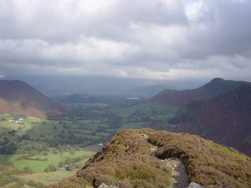
Rowling End - left, Swinside - centre and on the right Skelgill Bank leading from Derwent Water to Cat Bells from Scope End.

A glimpse of sunshine and a view along the Newlands Valley to Dale Head.

Hindscarth, Scope End and Robinson from Little Town.
