Height: 522 metres / 1713 feet Grid reference: NY 35472 29140 Category: The Northern Fells
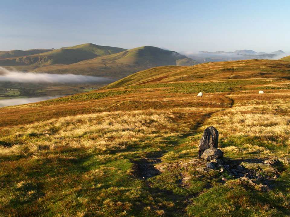
The summit of Souther Fell looking to Clough Head and the Dodds
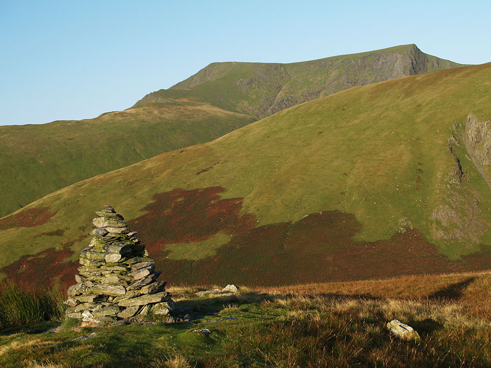
Blencathra from the southern cairn on Souther Fell
Height: 522 metres / 1713 feet Grid reference: NY 35472 29140 Category: The Northern Fells
The summit of Souther Fell looking to Clough Head and the Dodds
Blencathra from the southern cairn on Souther Fell
Start point: Mungrisdale (NY 361 303)
Mungrisdale – Souther Fell – Scales Fell – Blencathra – Bannerdale Crags – Bowscale Fell – The Tongue – Mungrisdale
Distance: 8.1 miles Total Ascent: 907 metres Time Taken: 4 hours Start Time: 08:40
Weather: An icy cold wind but clear. 5°C
There was a mighty cold and icy wind up on the top of Blencathra today and there was a fresh dusting of snow. The wind and ice were strong enough to keep me off Sharp Edge, that can wait until another day. To the south there was a big cloud build up and the way it lay right across the tops and kept changing made an intriguing backdrop throughout the walk.


The River Glenderamackin at Mungrisdale.

Sky over Great Mell Fell at the start of the climb to Souther Fell.

A bit leaden, but I wondered if it would brighten up?

Bowscale fell and The Tongue, the eventual route of descent.

Casper checks out Bannerdale and Bannerdale Crags. Blencathra is swathed in mist to the left.

The icy summit of Souther Fell. From here and right over Blencathra, the ice cold wind became quite strong.

The cairn at the south western end of Souther Fell.

Heading for Scales Fell.

Sharp Edge from Souther Fell.

The view of Sharp Edge and Foule Crag from Mousthwaite Comb.

Looking back to Souther Fell across Mousthwaite Comb.

Saddleback from Scales Fell.

A zoom shot showing the way the cloud was building to the south and that large layer pouring over the tops and into the valleys seemed to be creeping northwards.

Sharp Edge profile from Scales Fell.

Scales Tarn.

Doddick Fell Top and Scales Fell.

The icy summit of Blencathra, Hallsfell Top.

Hall's Fell Ridge.

Keswick and Derwent Water with that big cloud cap now on the high fells to the west.

Casper and Dougal on the summit of Blencathra.

Looks like playtime for the boys heading to Atkinson Pike.

The Back o' Skiddaw from the part frozen summit tarn.

A contrast in colours from Atkinson Pike.

Mono Blencathra.

The intriguing cloud cap to the south.

At the top of Sharp Edge.

Dougal Doo.

Descending Foule Crag, Bowscale Fell ahead.

Glenderamackin Valley.

Blencathra from Bannerdale Crags.

The main cairn to the north east.

Foule Crag on Blencathra from Bowscale Fell.

Skiddaw from Bowscale Fell summit.

Looks like that big cloud has overtaken Blencathra now as well.

Bowscale Fell from The Tongue.

Mungrisdale from the top of the steeper than steep descent.

Looking back to The Tongue from near Mungrisdale. By the time I got to the car and onto the A66, all the fells that I had been watching under cloud all morning were now clear with the exception of Blencathra which stood alone with its own cloud cap!
Start point: Mungrisdale (NY 361 303)
Mungrisdale – Souther Fell – Scales Tarn – Sharp Edge – Blencathra – Mungrisdale Common – Bannerdale Crags – Bowscale Fell – East Top on Bowscale Fell – Mungrisdale
Distance: 10.4 miles Total Ascent: 960 metres Time Taken: 4 hours 30 minutes
Weather: Sunny and bright. 18oC.
It was an early start again today, climbing Souther Fell with the sun rising across the low lying mist. By the time I reached Scales Tarn for the start of the climb of Sharp Edge, the sun was shining and the weather was glorious with lovely clear views all around; a glorious walk on a glorious day.


Sunrise in Mungrisdale at the start of the climb to Souther Fell, Little Mell Fell and Great Mell Fell in view.

There was lots of early morning mist this morning lying in the valleys.

Mungrisdale mist.

The Bowscale Fell ridge from Souther Fell. The final route of ascent later will be along it.

The summit of Souther Fell looking to Clough Head and the Dodds.

Blencathra clearly showing where the alternative name of Saddleback comes from with Bannerdale Crags in the foreground.

A lie down after the steep warm-up for Casper.

Blencathra from the southern cairn on Souther Fell.


A first glimpse of Sharp Edge from Mousthwaite Comb - it is the light band of rock arcing upwards to the highest pinnacle and looks almost impossible to climb from here.

Sharp Edge above Scales Tarn - it doesn't look quite as bad now.

The approach to Sharp Edge.

Up there?!

Climbing Sharp Edge.

Casper negotiates some of the slabs.

...and looking back down.

High above Scales Tarn now.

Made it! A lovely clear view from the summit of Blencathra today. To the north there were views to Scotland over low lying mist.

Wisps of cloud hang around on Hall's Fell Ridge.

The north western fells above Derwent Water and Keswick.

Casper.

Skiddaw from the summit tarn on Blencathra.

The Skiddaw massif across Mungrisdale Common.

Mungrisdale Common, that most derided of Wainwright fells as it is merely a large and grassy expanse with not a lot going for it - apart from today that is because Casper is there to liven the scene up! (Note: he is not there every day, unfortunately).

Sharp Edge from the climb to Bannerdale Crags, here seen rising from the centre up to the right.

Blencathra from the summit of Bannerdale Crags.

Looking east from the summit of Bowscale Fell.

Looking over Bowscale Tarn to Mosedale and High Pike from the East Top of Bowscale Fell.

Carrock Fell from the east ridge of Bowscale Fell.

Souther Fell from the descent across a sea of bracken.
Start point: Car Park above The White Horse Inn (NY 349 272)
Scales – Sharp Edge – Blencathra (100 – 105) (Atkinson Pike – Hallsfell Top – Gategill Fell – Blease Fell – Doddick Fell – Scales Fell) – Souther Fell (106) – Scales
Weather: Overcast, raining by the end.
As it is the first day of the school summer holidays, today’s walk was chosen by my 13 year old – an ascent of Blencathra via Sharp Edge; an excellent choice, I must say.
Bill Birkett counts the 6 separate tops on Blencathra as individual fells, so after ascending Sharp Edge we traversed the full Blencathra ridge and then crossed over onto Souther Fell.
The path starts from the car park above The White Horse, just off the A66 and immediately it is straight into a cruelly steep climb until the col is reached overlooking Mousthwaite Comb.


Sharp Edge from the col. From the col, the path follows the contour along the valley of the River Glenderamackin and then climbs up with Scales Beck to Scales Tarn.

Sharp Edge from Scales Tarn. From Scales Tarn, there is an excellent profile of Sharp Edge which looms menacingly. A left turn up the side of the slope and the bottom of Sharp Edge is reached.

The start of Sharp Edge.

Onwards and upwards along the rocky traverse.

Scales Tarn from Sharp Edge.

Looking up Sharp Edge. The final part of the Edge is the steepest; it is an exhilarating feeling looking down from this climb.

Sharp Edge from the top. At the top of Sharp Edge, it was straight up to the highest point, Atkinson Pike.

Skiddaw from Atkinson Pike..

and Blease Fell. From Atkinson Pike, it is along 'the saddle' to the summit.

The highest point on Blencathra is Hallsfell Top. This view is from the summit overlooking Derwent Water with the rest of the Blencathra ridge to the right. Walking along the undulating ridge, the next top is Gategill Fell.

Skiddaw Forest and the Back O' Skiddaw fells from Gategill Fell Top.

St. John's in the Vale and Thirlmere from Gategill Fell. Traversing right to the end of the ridge, the farthest point is Blease Fell. From Blease Fell, we retraced our footsteps along to the main summit and the descended via Doddick Fell and Scales Fell.

Looking back to Hallsfell top from Doddick Fell

and Sharp Edge from Scales Fell, right. We walked back down to the col overlooking Mousthwaite Comb and then carried on up the grassy rise along the undulating Souther Fell. This is the fell where legend has it a Spectral Army was seen on Midsummer Day 1745 by the local population.

Great Mell Fell and Little Mell fell from Souther Fell summit. Immediately after we hit Souther Fell summit, the heavens opened so it was a soggy return to the col and descent by the same path we came up to reach the car.
Mungrisdale – Bannerdale Crags – Mungrisdale Common (177) – Cloven Stone – Mungrisdale Common – White Horse Bent – Souther Fell (178) – Mungrisdale
A clear day at last, there was a cold wind above 500 metres.


Bannerdale Crags on the road from Mungrisdale.

Blencathra appears over the lip of Bannerdale Crags.

Blencathra from Bannerdale Crags summit.

Skiddaw from the 'summit' cairn of Mungrisdale Common.

Derwent Water and the distant Fells from Mungrisdale Common. L-R: Bowfell, Esk Pike Scafell, Lingmell, Great Gable, Kirk Fell, Dale Head, Hindscarth, Pillar, Robinson. In the foreground, Blease Fell is to the left and Lonscale Fell to the right.

'Cloven Stone' - marked on the O.S map and by AW.

White Horse Bent

Sharp Edge and Blencathra from White Horse Bent.

outhwest from Souther Fell, in the foreground Clough Head is to the left, Blencathra to the right. On the horizon L-R: Crinkle Crags, Bowfell, Esk Pike, Scafell, Lingmell, Great Gable, Brandreth and Kirk Fell.

Blencathra and Scales Fell from the summit of Souther Fell.