Height: 553 metres / 1814 feet Grid reference: NY 31944 11157 Category: The Central Fells
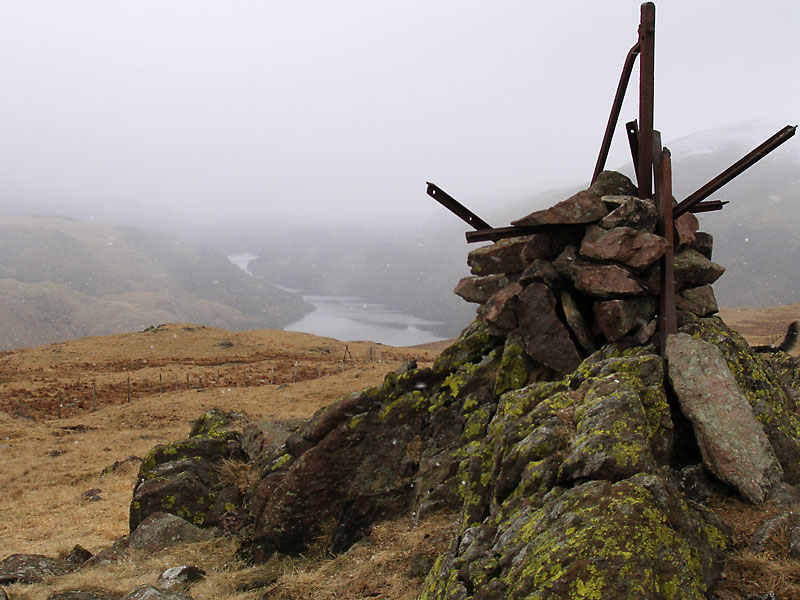
Steel Fell summit
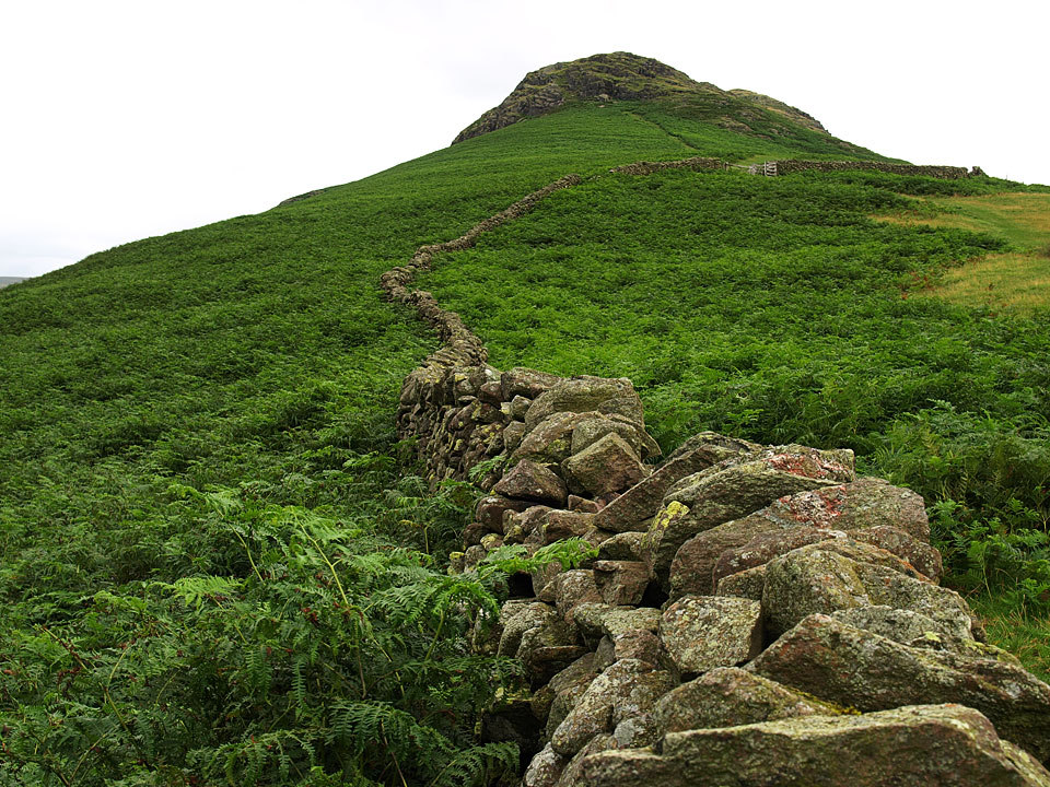
The climb to Steel Fell from the south
Height: 553 metres / 1814 feet Grid reference: NY 31944 11157 Category: The Central Fells
Steel Fell summit
The climb to Steel Fell from the south
Start point: Steel End (NY 320 129)
Steel End – North Ridge – Steel Fell – Rake Crags – Wyth Burn Valley – Steel End
Distance: 2.9 miles Total Ascent: 366 metres Time Taken: 1 hour Start Time: 10:45
Weather: Sunny and warm but hazy. 15C
Time was in short supply today but the weather was far too good to miss this direct walk to Steel Fell climbing the north ridge. It was really warm but very hazy so the views weren’t so far reaching – nice to feel warm sunshine on my back today though.

Steel Fell route map.

Wyth Burn.

Steel Fell in mono.

Looking across to Helvellyn.

Dougal finds the path to climb the north ridge of Steel Fell.

Looking back down to Steel End (the farm has changed it's name to West Head now).

Dollywaggon Pike and Birkside Gill across the main road.

Thirlmere from the north ridge and a line of haziness visible.

Looking back down the steep north ridge, Nethermost and Dollywaggon Pikes opposite.

...and again from higher up.

At the top of the north ridge.

The incline suddenly becomes much gentler en route to the summit. Casper finds the best way to cross the fence whilst Dougal...watches sheep!

Seat Sandal.

Hot Dogs - the scissors are being sharpened for Casper and Dougal as I type!

The summit of Steel Fell looking across to Dollywaggon Pike, St. Sunday, Fairfield and Seat Sandal.

Following the fence along the ridge to Calf Crag, beyond is Greenup Edge where I walked on Monday. I made up today's walk as I went along and opted for the quick descent route following the fence down from the corner in this photo.

Casper ponders the route.

Nab Crags and the Wyth Burn valley - and the steep descent. Dougal continues his favourite pastime of sheep watching.

Into the sun, looking back at the route of descent.

A final view back into Wyth Burn before the return to Steel End.
Start point: Roadside parking near to Helmside (NY 332 096)
Helmside – Cotra Breast – Steel Fell – Brownrigg Moss – Calf Crag – Gibson Knott – Helm Crag – Thorny How – Low Mill Bridge – Helmside
Distance: 6.8 miles Total Ascent: 653 metres Time Taken: 3 hours
Weather: Overcast, showers towards the end. 22ºC.
Today was another day when I ended up doing a walk that I had not planned – I was off to the western fells but it was bucketing down with rain over that way and I could see it was brighter to the north east, so that was good enough for me. I think I was lucky to finish this walk relatively dry too as the rain came in as I reached valley level.


Greenburn with Steel Fell to the right.

Looking across to Helm Crag.

The same view from higher up the climb to Steel Fell.

Climbing Cotra Breast.

A good view of the Helm Crag to Gibson Knott ridge, the route of return.

Helvellyn from Dead Pike, the summit of Steel Fell.

Hmm, not much running water up here for Casper to have a bathe in, just boggy puddles.

Thirlmere and Blencathra from Steel Fell.

The route arcs round to the left past the un-named tarn. Beyond is the High Raise plateau.

Blencathra and Clough Head.

Ullscarf.

Helvellyn.

Calf Crag summit looking along the ridge to Grasmere.

Wrong way Casper, we are off to Gibson Knott!

Saint Sunday Crag.

Tarn Crag and Far Easedale.

The Langdale Pikes beyond Tarn Crags from Gibson Knott.

Casper strikes the mountain dog pose on the way to Helm Crag.

Easedale Tarn is now in view on the upper left with Sergeant Man beyond Tarn Crag.

The climb to Helm Crag from Bracken Hause.

Steel Fell from the top of The Howitzer, the true summit of Helm Crag.

The Lion and The Lamb on the left, Loughrigg Fell and Grasmere from The Howitzer.

The view across to Seat Sandal, Fairfield and Great Rigg from The Howitzer.

Steel Fell beyond the rocky pinnacle that is The Howitzer.

The path to The Lion and The Lamb.

Grasmere from The Lion.

Looking back to Steel Fell.
Start point: Grasmere (NY 337 076)
Grasmere – Goody Bridge – Helmside – Steel Fell (464) – Greenup Edge – Brownrigg Moss – Low White Stones – High Raise – Sergeant Man – Codale Head – Brownrigg Moss – Calf Crag – Gibson Knott – Helm Crag – Grasmere
Distance: 11 miles Total Ascent: 1000 metres Time Taken: 5 hours
Weather: Dull and grey with the snow showers. 5°C
Today’s walk was from Grasmere with a circuit of Greenburn, also taking in High Raise and Sergeant Man. There was lots of snow about today with mini-blizzards on the higher sections of High Raise and Sergeant Man.


Looking across to Helm Crag from the steep ascent to Steel Fell.

Lots of OFC members and dogs on the way up to Steel Fell.

Looking across to the snow capped Helvellyn ridge across Dunmail Raise.

Seat Sandal.

Looking back down Steel Fell to Helm Crag with Grasmere beyond with the snow falling now.

Steel Fell summit.

Thirlmere from Steel Fell.

Helvellyn across an un-named tarn on the ridge to Gibson Knott.

Brownrigg Moss with Greenup Edge in the distance - the route to High Raise.

An icy beck on Low White Stones.

The central fells and Bassenthwaite Lake.

Steel Fell just beneath the clouds from Low White Stones.

Langstrath from High Raise.

Angus complete with snowy beard on High Raise.

A snowy High Raise summit.

Bow Fell from High Raise.

Crinkle Crags from a frozen tarn below Sergeant Man's summit.

Pavey Ark and Harrison Stickle from Sergeant Man.

On the edge of Sergeant Man, Stickle Tarn below.

A snowy Saint Sunday Crag and Fairfield contrast against Dollywagon Pike and Seat Sandal with Steel Fell in the centre.

The Lion and The Lamb from the top of the Howitzer, the summit of Helm Crag; Grasmere and Loughrigg Fell beyond.

Grasmere from The Lion and The Lamb.

Easedale.

Helm Crag from Easedale.
Grasmere – Steel Fell (186) – Calf Crag – Greenup Edge – Ullscarf (187) – Long Crag – Sergeant’s Crag (188) – Eagle Crag (189) – Sergeant’s Crag – Low White Stones – High Raise – Thunacar Knott (190) – Sergeant Man – Blea Rigg (191) – Silver How (192) – Grasmere
A raw and bitterly cold day, icy wind on the tops with lots of snow.


Helm Crag from the ascent of Steel Fell. Loughrigg is to the distant left.

Steel Fell summit cairn.

Two un-named tarns on the walk to Calf Crag, Greenup Edge behind.

Calf Crag summit.

A frozen Ullscarf summit cairn.

Greenup Valley.

Ullscarf.

Sergeant's Crag summit.

Borrowdale from Eagle Crag.

Icicle formation on Low White Stones.

High Raise Trig. column.

High Raise from Thunacar Knott.

Sergeant Man summit looking towards Stickle Tarn and Pavey Ark.

Stickle Tarn, Harrison Stickle and Pavey Ark across Bright Beck.

Two Tarns - Codale Tarn.....

and Easedale Tarn.

Pike O'Stickle from Blea Rigg summit.

Grasmere and Rydal Water from Silver How.