Height: 765 metres / 2510 feet Grid reference: NY 24943 04119 (says Birkett, I think it is NY 25123 04051!)
The Crinkle Crags from Stonesty Pike
Height: 765 metres / 2510 feet Grid reference: NY 24943 04119 (says Birkett, I think it is NY 25123 04051!)
The Crinkle Crags from Stonesty Pike
Start Point: Cockley Beck (NY 246 016)
Cockley Beck – Moasdale – Lingcove Beck – High Gait Crags – Yeastyrigg Crags – Pike de Bield – Esk Pike – Ore Gap – Bowfell – Three Tarns – Shelter Crags – Crinkle Crags – Stonesty Pike – Little Stand – Ulpha Fell – Cockley Beck
Distance: 9 miles Total Ascent: 1013 metres Time Taken: 6 hours Start Time: 07:30
Weather: Lovely, 21°C
It was perfect summer weather for a walk up to Esk Pike from Cockley Beck – this is definitely the quiet way to do these fells and I didn’t see anyone until 3 Tarns and then one or two on Crinkle Crags. By the end I was completely boiled, but hey – not complaining! This walk will feature in Trail magazine later this year.

First sight of the Scafells from Moasdale this morning - lovely.

Scafell and Scafell Pike before heading down to cross Lingcove Beck.

The south ridge to Esk Pike in the foreground.

Close up on Scafell Pike, Scafell to the left and Ill Crag to the right.

Scafells panorama.

Fine views from High Gait Crags.

Mono Pike.

The King of the Fells and the fell that is king.

Looking back along the ridge to Hard Knott and Harter Fell.

The Lion King.

Climbing higher across Yeastyrigg Crags.

Looking across Pike de Bield to the Scafells. Further along from Pike de Bield is a large cairn (marked 'memorial cairn' on 2nd edition Wainwright's), the brass plaque on it says 'Gerry Charnley 1929 - 1982.

Langstrath from Esk Pike summit. Esk Pike and Bowfell were swirling in and out of the mist all morning and it was a shock to hit the cold air.

Heading for Bowfell across Ore Gap.

The dark outline is the south ridge of Esk Pike (just climbed) and beyond is the finest view of the Scafells of all, taken from Bowfell.

The Great Slab of Flat Crags and the Langdales.

Crinkle Crags across Three Tarns.

Down at the tarns and a chance for Dougal to cool off.

Pike o' Blisco, Windermere beyond from Crinkle Crags.

The highest swimmer in England at 854m in Crinkle Crags Tarn.

Rounding Long Top, Dougal checks out the way across the fifth (or first!) Crinkle and over to Stonesty Pike and Little Stand.

Great Langdale.

Stonesty Pike summit - I think Birkett got the wrong one when he chose it.

Beautiful weather and pools on Little Stand.

The Duddon Valley from the descent of Little Stand.

Looking back up from the road - there is a way down somewhere!
Start point: Cockley Beck (NY 246 016)
Cockley Beck – Moasdale – Lingcove Beck – Three Tarns – Bow Fell – Climbers Traverse – Three Tarns – Shelter Crags – Crinkle Crags – Stonesty Pike – Little Stand – Ulpha Fell – Cockley Beck
Distance: 8.8 miles Total Ascent: 1127 metres Time Taken: 4 hours
Weather: Sunny and warm. 20°C.
Today was an almost unseasonally warm day, just like midsummer. I had a walk from Cockley Beck at the head of the Duddon Valley up to Bow Fell and back along the Crinkle Crags. I had forgotten how rough the terrain was, especially for a dog, but Angus seemed to take it all in his stride. There isn’t a full set of photographs today as the camera battery decided to give up along the Climbers Traverse on Bow Fell – I must remember to recharge it in future! Hopefully the photographs I did manage to capture show the flavour of the walk terrain and conditions.

Bow Fell route map.

Little Stand and Ulpha Fell from Moasdale. The final route of descent was straight down the middle which was very rough - not recommended.

The Scafells appear from the boggy walk along Moasdale.

The Scafell range.

Esk Pike and Bow Fell.

Bow Fell links.

Looking back along Lingcove Beck from the approach to Three Tarns.

The Scafells across one of the Three Tarns.

The Crinkle Crags across Three Tarns from the climb to Bow Fell.

Angus on the summit of Bow Fell.

Scafell and Scafell Pike separated by Mickledore.

One man and his dog looking down The Great Slab on Bow Fell.

The Langdale Pikes across the infeasibly angled Great Slab of Flat Crags.

The Langdale Pikes and Mickleden from the Climbers Traverse.
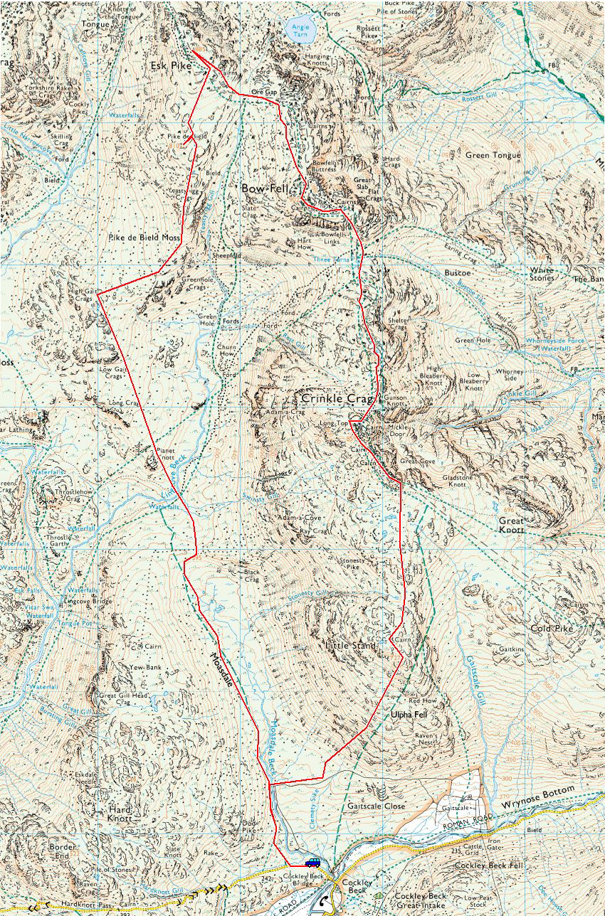
Start point: Cockley Beck (NY 246 016)
Cockley Beck – Moasdale – Lingcove Beck – High Gait Crags (254) – Yeastyrigg Crags – Pike de Bield (255) – Esk Pike (256) – Ore Gap – Bow Fell – Three Tarns – Shelter Crags – Crinkle Crags – Stonesty Pike (257) – Little Stand (258) – Ulpha Fell – Cockley Beck
Weather: Mainly clear interspersed with cloud and a biting wind on the tops. Snow above 600m.
Today’s walk was a l o n g walk from Cockley Beck to Esk Pike and Bow Fell. The long, boggy run in along Moasdale was helped by the spectacular views (the best?) of Bow Fell, Esk Pike and the Crinkle Crags. The Sca Fells were in cloud all day so I didn’t get to see to much of them , unfortunately. I really rated this walk – thoroughly enjoyable from start to finish.

Bow Fell route map.

Elevation profile of the route. Key: HGC=High Gait Crags, PdB=Pike de Bield, EP=Esk Pike, BF=Bow Fell, SC=Shelter Crags, CC=Crinkle Crags, SP= Stonesty Pike, LS= Little Stand

3D image of the walk route.

Looking back along Moasdale.

Esk Pike and Bow Fell from above Lingcove Beck.

The mighty Bow Fell.

Esk Butress on Scafell Pike from High Gait Crags.

The River Esk and Great Moss from Pike de Bield.

A frozen Esk Pike summit.

The Langdales and Mickleden from the ascent of Bow Fell.

A contrast in colours - Lingcove Beck from Bow Fell summit.

'The Bad Step', right of centre, used in descent from the second Crinkle.

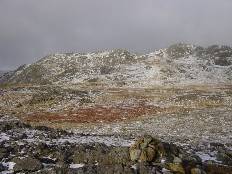
The Crinkle Crags from Stonesty Pike.

Pike O' Blisco and Cold Pike from Little Stand.

Cockley Beck Bridge.