Height: 493 metres / 1617 feet Grid reference: NY 20634 25339
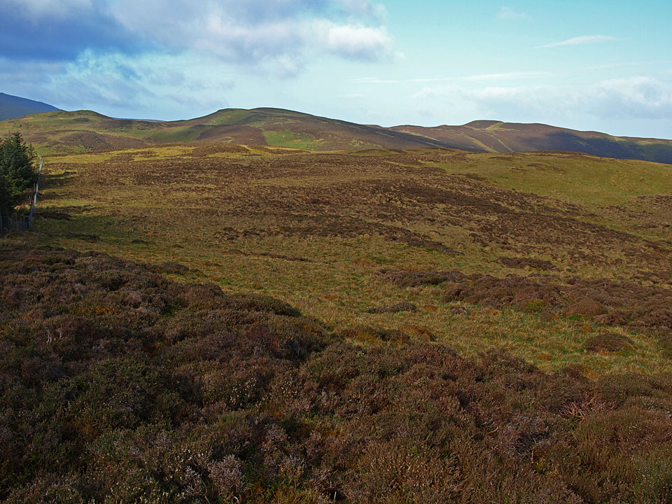
Whinlatter from Tarbarrel Moss, one of the most disappointing of all the Birkett ‘summits’
Height: 493 metres / 1617 feet Grid reference: NY 20634 25339
Whinlatter from Tarbarrel Moss, one of the most disappointing of all the Birkett ‘summits’
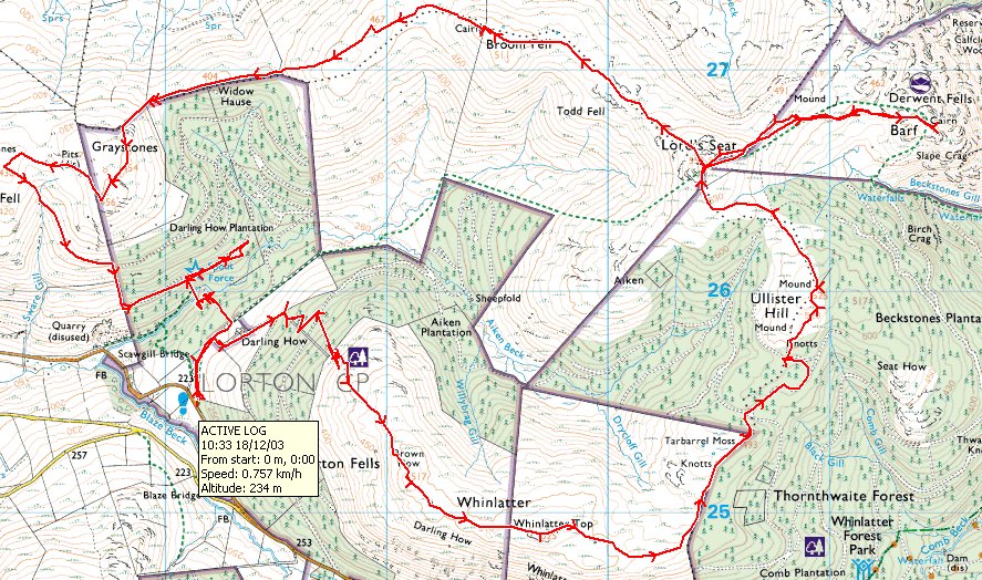
Start point: Darling How (NY 181 255)
Darling How – Brown How on Whinlatter – Whinlatter Top – Tarbarrel Moss – Ullister Hill – Lord’s Seat – Barf – Broom Fell – Graystones – Spout Force – Darling How
Distance: 8.6 miles Total Ascent: 786 metres Time Taken: 5 hours Start Time: 07:10
Weather: Mist at first, improving to sunny spells. 10C.
The rain was absolutely bouncing before dawn this morning and I was wondering whether it was indeed a good idea to venture out in such conditions. As it was the rain eased and stopped before I met up with Andy Lang and Gary Jones for a walk around the Whinlatter fells and the weather was ever improving with particularly good views from Barf today. There was plenty of boggy ground to be traversed today though after the recent wet weather.

Whinlatter route map.

A murky start climbing through the old tree stumps of Aiken Plantation, Broom Fell in cloud to the left and distant Lord's Seat. We had an 'interesting' climb through the upper plantation slopes!

As we climbed to Whinlatter, the mist engulfed us for a while, here parting briefly to give a glimpse of Lorton Vale.

Brown How, the summit of Whinlatter, with the sun trying to burn through the cloud.

On Whinlatter Top.

Two photographers snapping Grisedale Pike.

Interesting skies and it's all looking quite promising.

The sun shone through whilst we crossed Tarbarrel Moss looking back along the fence to Grisedale Pike.

Whinlatter from Tarbarrel Moss.

The day is ever improving on Ullister Hill looking through to Embleton.

Lord's Seat, the next objective.

Barf and Skiddaw from Lord's Seat.

Lord's Seat from Barf.

Bassenthwaite Lake.

The Vale of Keswick and Derwent Water.

The summit of Barf looking back to Lord's Seat.

Casper and Dougal in the sunshine.

Five Amigos - Andy, me, Gary, Dougal and Casper.

The way back.

Skiddaw.

A close up on Dodd and Skiddaw.

The distant cairn visible on Broom Fell.

Skiddaw from Broom Fell.

Heading for Broom Fell.

The view back to Lord's Seat.

Mono Broom Fell.

Looking to Skiddaw.

Descending to Widow Hause.

On the Birkett summit of Graystones (the highest point).

Fingers of light on Wainwright's Graystones summit.

The steeper than steep descent from Graystones.

Sunshine through the clouds.

Spout Force. Much later, heading into Troutbeck...

Beautiful Autumn colours.
Start point: Darling How (NY 181 255)
Darling How – Brown How on Whinlatter – Whinlatter Top – Tarbarrel Moss – Ullister Hill – Lord’s Seat – Barf – Broom Fell – Graystones – Spout Force – Darling How
Distance: 8.6 miles Total Ascent: 786 metres Time Taken: 3 hours 40 minutes
Weather: Sunny spells, strong winds. 9°C.
I finally made it back to Whinlatter – I have lost count of the number of times that I have been on my way to do this walk and then been swayed by something else on the way for one reason or another. The most recent example was last week when I was enticed by Blencathra even though I was all set to do this round. The last time I was here was 2004 BC (Before Casper) and I kept thinking back to Angus being with me on this walk, back in those early website days…

Whinlatter route map.

Broom Fell ahead following the forest road from Darling How.

Early morning sunburst over Lord's Seat.

Climbing up the faint path alongside the wall. This section has all been deforested since last time I was here but there are already signs of regrowth.

Grisedale Pike, Hopegill Head and Grasmoor are the main fells in this photo looking from the wind shelter on Brown How, the Wainwright summit of Whinlatter.

Grisedale Pike and Hobcarton Head from the east top of Whinlatter.

The sun tries to break through the clouds to the east from Whinlatter Top, the higher of the two tops on Whinlatter.

Whinlatter from Tarbarrel Moss, one of the most disappointing of all the Birkett 'summits'.

Blue sky over the north western fells from Ullister Hill.

Skiddaw from Lord's Seat, Barf in the foreground - that's where we are off to next.

Looking back over Whinlatter to Grisedale Pike from Lord's Seat.

Bassenthwaite Lake and Binsey.

The view over the southern end of Bassenthwaite Lake towards Keswick and Derwent Water.

Skiddaw and Dodd.

Looking back to Lord's Seat from Barf.

Mucky pup on the throne of Barf.

After a boggy traverse back to Lord's Seat, this is the view to Broom Fell with the clouds fleeting across the sky now in a strong - and cold - wind.

Whinlatter from Todd Fell. The route I used in the ascent of Whinlatter is the wall line up the deforested area to the edge of the trees.

The fine cairn on Broom Fell looking back to Lord's Seat.

Heading for Graystones and no wonder Casper is running for it, it was blowing a gale along here. It was a blessed relief to get down to Widow Hause and take shelter from the wind behind the trees.

The Wainwright summit of Graystones lies just to the west of the broken wall although it is lower than other areas on the map. This view is into Lorton Vale with Mellbreak and Low Fell in the middle distance.

This is a steep way down Casper!

Hopegill Head and Ladyside Pike from the descent.

Scawgill Bridge.

Spout Force.

Graystones from Darling How.
Start point: Thornthwaite (NY 220 264)
Thornthwaite – Barf (241) – Lord’s Seat (242) – Broom Fell (243) – Graystones (244) – Kirk Fell on Lorton (245) – Spout Gill – Brown How on Whinlatter (246) – Whinlatter Top (247) – Tarbarrel Moss (248) – Ullister Hill (249) – Seat How (Thornthwaite) (250) – Thornthwaite
Weather: Dull, overcast – gale force winds and driving rain.
Today’s walk started with a steep ascent up to Barf from Thornthwaite – I think I found out why it is called Barf going up there! The weather was absolutely atrocious – gale force winds and driving rain, especially on the exposed sections from Lord’s Seat to Broom Fell and across Whinlatter. The forest sections came as a welcome relief from the constant battering today.


Spout Force Car Park – Brown How on Whinlatter – Whinlatter (154) – Tarbarrel Moss – Ullister Hill – Lord’s Seat (155) – Barf (156) – Lord’s Seat – Broom Fell (157) – Graystones (158) – Kirk Fell on Lorton – Spout Force – Spout Force Car Park
A clear day, warm for the time of year.

Graystones from the Spout Force car park.

Brown How on Whinlatter summit. L-R Grisedale Pike, Eel Crag, Sand Hill, Hobcarton Crag, Hopegill Head, Ladyside Pike, Grasmoor (in cloud), Whiteside.

The Eastern top of Whinlatter looking toward the Skiddaw massif.

Skiddaw from Tarbarrel Moss.

The High Street ridge from Tarbarrel Moss.

Lord's Seat from Ullister Hill.

Looking to Longside Edge and Skiddaw from Lord's Seat summit.

Broom Fell from Lord's Seat.

Skiddaw and Longside Edge from the summit of Barf.

Broom Fell summit cairn looking towards Skiddaw and Longside Edge.

Whinlatter from Widow Hause.

Broom Fell and Lord's Seat from Graystones summit with Skiddaw in the distance.

Lorton Vale from the descent of Graystones. Mellbreak has the sunrays shining on it in the centre.

Spout Force waterfall.