Height: 284 metres / 630 feet Grid reference: SD 22421 91936 Category: The Outlying Fells
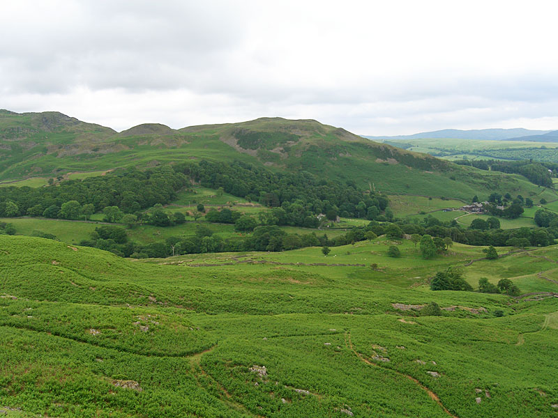
Looking across Dunnerdale to The Knott
The Knott
Height: 284 metres / 630 feet Grid reference: SD 22421 91936 Category: The Outlying Fells
Looking across Dunnerdale to The Knott
The Knott
Start point: Kiln Bank Cross (SD 215 933)
Kiln Bank Cross – Stickle Pike – Tarn Hill – Great Stickle – Scrithwaite Farm – Knott End – The Knott(OF) – Raven’s Crag – Stainton Ground Quarries – Kiln Bank Cross
Distance: 4.8 miles Total Ascent: 700 metres Time Taken: 2 hours 30 minutes
Weather: Overcast, clearing later. 14oC.
It was the same today as yesterday – it looked like someone had ruled a line at 400m and that was the cloud base across the whole of the southern Lake District. The Dunnerdale Fells were beneath the clouds, so that’s where I headed but even that looked a bit iffy at the start with the odd shower whilst I was on Stickle Pike. By the time I reached the return leg, the clouds quickly cleared away and even gave a hint of blue sky – it just shows how quickly it can all change.


Looking over Dunnerdale to Raven's Crag and The Knott, to be used on the return leg. The weather didn't look too hopeful as even these lowly tops were catching a bit of the cloud.

Stickle Tarn.

The route to Stickle Pike.

Casper caught in flight near Stickle Tarn.

Getting cosy on Stickle Pike.

The way ahead is the Tarn Hill - Great Stickle ridge running from right to left.

Stickle Pike from Tarn Hill.

Tarn Hill and Great Stickle with the Duddon Estuary beyond.

Looking back to Stickle Pike with Caw putting in an appearance from the cloud as it starts to lift in the distance.

The cloud starts to lift from Green Crag to the north.

Stickle Pike and Caw from one of the many tarns on the aptly named Tarn Hill.

Still a heavy looking sky over the Duddon Estuary, from Great Stickle.

Looking across Dunnerdale to The Knott, the next objective.

Stickle Pike along Dunnerdale.

Amazingly, blue skies appeared as I climbed The Knott, here looking along the Lickle Valley to the Duddon Estuary.

Even Black Combe is there now - so that's what it looks like!

A panoramic view of the Great Stickle to Stickle Pike ridge.

Raven's Crag from The Knott.

Stickle Pike over Hoses.

Even the higher fells can be seen now with Harter Fell left of centre distance with Scafell behind. The distinctive 'crinkly' Esk Pike and the pyramidal Bow Fell are in the right distance.

Caw.

A close up of Stickle Pike, the disused quarry giving away the secret of it's industrial past.

Hesk Fell.
Start point: Broughton Mills (SD 222 906)
Broughton Mills – Great Stickle (107) (OF) – The Dunnerdale Fells – Tarn Hill (108) (OF) – Stickle Pike (109) (OF) – The Knott (OF) – Broughton Mills
Weather: Sunny and bright.
A short walk in the sunshine today around Broughton Mills taking in a lovely round including Stickle Pike – well worth visiting for the views of the high fells, especially the Scafell and Bowfell ranges.
As well as taking in the Birkett tops, parts of this walk are described in Wainwright’s Stickle Pike chapter in his book ‘The Outlying Fells of Lakeland’, page 126.
From Broughton Mills, I crossed the River Lickle over the bridge and followed the tarmac up to Green Bank Farm where the road petered out into a track and then an overgrown path. Through the woods, the path changed into a walled green lane which skirts the base of Hovel Knott.


Hovel Knott and Great Stickle from the green lane. The path bears off to the right and heads up to the summit of Great Stickle.

The Duddon Estuary from Great Stickle.

Stickle Pike from Great Stickle. From Great Stickle, the path either heads directly to Stickle Pike or traverses the Tarn Hill ridge. I headed for the ridge after making a slight detour to the Dunnerdale Fells summit after confusion arose from my Dunnerdale Fells walk on 1.7.04 when it appeared I never quite reached the correct summit. This turned out to be the case and the correct summit is about 200 metres north west of my original position.

Looking from the cairned summit of the Dunnerdale Fells to the Duddon Estuary. A quick walk past a couple of un-named tarns took me to the summit cairn of Tarn Hill.

The Scafell range and Stickle Pike from Tarn Hill summit. An easy traverse of the ridge where tarns abound brought me to the foot of Stickle Pike.

Stickle Pike from the Tarn Hill ridge. Note the ancient stone circle cairn at the foot of the picture. It was down to the stone circle in the grass depression and up the path to the right of Stickle Pike to the col and then left up the very steep path to the summit of Stickle Pike. The view of Bowfell and the Scafell range from the col and from the summit of Stickle Pike is absolutely magnificent.

Harter Fell in the foreground, the Scafell range to the left and Bowfell in the centre from the summit of Stickle Pike. I then descended back to the col using the same path, past Stickle Tarn down to the fell road.

Stickle Tarn. Across the fell road and along the spoil heaps with the ridge above being the target. I contoured along the low level path longer than the AW route and ascended directly to Raven's Crag. It was interesting to note that the nameless summit 1183' quoted by Wainwright is actually called Raven's Crag by Birkett and Wainwright's Raven's Crag is not named by Birkett!

Stickle Pike over Hoses farm from the low level path. From Raven's Crag there is a descent to a large depression and the an easy, grassy walk to The Knott.

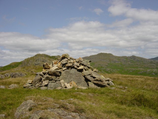
Cairn on The Knott looking to Raven's Crag and Caw.

Black Combe from The Knott. From The Knot, it was straight down over Knott End to the tarmac and back to Broughton Mills past the church.

Holy Innocents Church, Dunnerdale

and the sign at the start of the walk