Height: 364 metres / 1194 feet Grid reference: NY 42233 06384 Category: The Far Eastern Fells
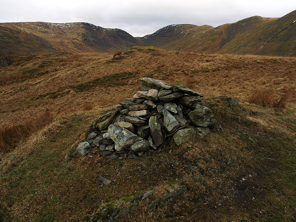
The summit of Troutbeck Tongue
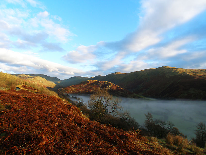
The Troutbeck Valley from the Kirkstone Pass road with Troutbeck Tongue centre.
Height: 364 metres / 1194 feet Grid reference: NY 42233 06384 Category: The Far Eastern Fells
The summit of Troutbeck Tongue
The Troutbeck Valley from the Kirkstone Pass road with Troutbeck Tongue centre.
Start point: Nr Town Head, Troutbeck (NY 414 037)
Town Head, Troutbeck – Ing Lane – Ing Bridge – Hagg Bridge – Troutbeck Tongue – Hagg Bridge – Ing Bridge – Ing Lane – Town Head, Troutbeck
Distance: 4.7 miles Total Ascent: 291 metres Time Taken: 2 hours Start Time: 09:30
Weather: Wetter than wet. 11°C
Everywhere seemed a bit damp and overcast in the south Lakes this morning but Troutbeck Tongue seemed a decent bet to miss the worst of it…that shows what I know!

Troutback Tongue route map.

Ing Lane and The Tongue - this was taken just as it started raining and so has the honour of being the driest photo of the whole walk!

Further along the lane The Tongue is ahead and now we are walking in proper rain.

Let's all do the conga.

Troutbeck from the southern slopes of The Tongue.

Damp Casper and Dougal.

Climbing higher.

Nothing to be seen at the summit...

...until I walk away from it and the cloud briefly clears to give a glimpse of Windermere.

A 180 panoramic from the top looking towards Park Fell Head - at least it gives a good idea of the conditions.

The old slate bridge.

Trout Beck.

If anything it is raining even heavier now on the way back and I am definitely feeling like a drowned rat.

The slopes of Yoke in mono.
Start point: Nr Town Head, Troutbeck (NY 414 037)
Town Head, Troutbeck – Ing Lane – Ing Bridge – Hagg Bridge – Troutbeck Tongue – Hagg Bridge – Ing Bridge – Ing Lane – Town Head, Troutbeck
Distance: 4.7 miles Total Ascent: 291 metres Time Taken: 2 hours Start Time: 10:10
Weather: Sunny and warm. 20C
Wow, what a difference today in the weather as it really was unseasonably warm and it was great to see the sunshine once more. All the paths around here still seemed very wet though after the recent heavy rains and the return leg past the old slate bridge was a rather squelchy affair to say the least.

Troutbeck Tongue route map.

The Tongue along Ing Lane with the Ill Bell ridge to the right. There is still a bit of cloud lingering over there.

Yoke.

Which way Casper?

White horses.

It's clearing out already over there.

The Tongue ahead.

Autumn colours.

Even more vivid Autumn berries.

Looking across to Wansfell.

The mountain lions on the climb.

Sunshine over Froswick, Ill Bell and Yoke.

Those two seem to know the way, or have they spotted something? It was absolutely boiling on this climb, just like the return of summer.

Casper in action.

Quarry workings below Yoke.

The Tongues on The Tongue.

Dougal leads the way to the summit.

As we reached the top, the sun disappeared and the wind seemed to pick up. This hazy view to Windermere is from the summit of Troutbeck Tongue.

The summit and Windermere from further along the ridge.

A panoramic view of Troutbeck Park.

Threshthwaite Mouth.

Red Screes beyond Woundale.

The old slate bridge crossing Trout Beck.

The bridge and Troutbeck Park.

The sun has returned and the waterfalls look spectacular in it.

Beatrix's old house.

Sunshine in Troutbeck Park.

Looking back to Troutbeck Tongue.

Now it really was beautiful in the bright sunshine.


Vibrant Tongue.

Start point: Kirkstone Pass road (NY 412 063)
Kirkstone Pass road – Troutbeck Park – Troutbeck Tongue – Troutbeck Park – Kirkstone Pass road
Distance: 2.25 miles Total Ascent: 240 metres Time Taken: 1 hour
Weather: Sunny gradually clouding over. 18C.
It is not often you start the climb to a fell with a big descent but I did today for a walk to Troutbeck Tongue, starting from the Kirkstone Pass road. It was an interesting descent and pretty boggy underfoot until the climb of The Tongue itself. Once on the summit, there was cause for a little celebration as you will see…

Troutbeck Tongue route map.

Froswick and Ill Bell from the start of the descent into Troutbeck Park from the Kirkstone Pass road.

Heading into Troutbeck Park.

Yoke beyond The Tongue.

Trout Beck.

Cascades on Trout Beck.

The old slate bridge crossing Trout Beck.

It is a simple construction of stone slabs lying across the pillars and looks as though it has been there forever - and probably has.

The view to Park Fell Head from the climb to Troutbeck Tongue.

Wansfell Pike and Wansfell, the Kirkstone Pass road running below it through the centre of the photo.

Caudale Moor and Thornthwaite Crag either side of Threshthwaite Mouth. Gray Crag can just be seen through the gap.

Thornthwaite Crag, Froswick and Ill Bell from the Troutbeck Tongue ridge.

A close up on Threshthwaite Mouth.

Windermere beyond the summit of Troutbeck Tongue.

The summit view to Windermere.

The Tongue on The Tongue - congratulations to Casper who completed his 214th and final Wainwright fell here today.

For his efforts, the reward of a meaty bone - a doggy equivalent to a bottle of champagne.

The Troutbeck Valley and Windermere.

I can see this may take some time to devour!

Wansfell from the descent.

Climbing back to the Kirkstone Pass road after crossing the slate bridge once more.

Troutbeck Tongue from the Kirkstone Pass road.
Start point: Nr Town Head, Troutbeck (NY 414 037)
Town Head, Troutbeck – Ing Lane – Ing Bridge – Hagg Bridge – Troutbeck Tongue – Hagg Bridge – Ing Bridge – Ing Lane – Town Head, Troutbeck
Distance: 4.2 miles Total Ascent: 291 metres Time Taken: 1 hour 30 minutes
Weather: Warm with the odd sunny interval. 8°C.
It certainly felt like Spring had sprung today for a walk in Troutbeck Park to the relatively modest Troutbeck Tongue, a fell that I have managed to neglect for nearly 4 years. It felt like something was missing today, I can’t quite put my finger on it…


Ill Bell and Yoke over Town Head.

Descending to Ing Lane in a brief interlude of sunshine.

Looking along Troutbeck to The Tongue (above the barn) with the magnificent Thornthwaite Crag, Froswick, Ill Bell, Yoke ridge beyond.

The Tongue, Troutbeck.

A stile with nothing to climb over, pointing the way towards Threshthwaite and the promise of blue sky and sunshine.

Troutbeck Park Farm and The Tongue. This farm was the former residence of Beatrix Potter and the area was used as the setting in several stories.

The Hagg Gill path.

Correspondent Dudley Chignall asked if I could find this scene from Potter's 'Pigling Bland' which is based to the east of Troutbeck Park Farm. The answer is...well, no - not quite anyway. You can see the bridge in the drawing and the gash of the waterfall, the nearest I could see is in the photo below with the bridge and the waterfall both in evidence and the tops look remarkably similar too. Artistic licence, wrong angle or was I in the wrong place?


Threshthwaite Mouth from the direct route to the top of Troutbeck Tongue.

Windermere from the summit of The Tongue.

Sour Howes and Sallows from Troutbeck Tongue.

The summit of Troutbeck Tongue.

A 180 degree panorama from Troutbeck Tongue. Select on the image to open a larger version.

Red Screes and St Raven's Edge with the Kirkstone Pass road in view to the centre left.

Windermere.

Wansfell above Troutbeck Park Farm.

A bit of sunshine over Troutbeck on the walk back.
Start point: Kirkstone Pass road (NY 412 063)
Kirkstone Pass – Woundale – St. Raven’s Edge (345) – John Bell’s Banner (346) – Caudale Moor (Stony Cove Pike) (347) – Threshwaite Mouth – Park Fell Head – Troutbeck Park – Troutbeck Tongue (348) – Kirkstone Pass
Distance: 10.1 miles Total Ascent: 929 metres Time Taken: 4 hours 20 minutes
Weather: Rain, heavy at times, clearing by the end. 12-15°C.
The heavens had opened when I set off this morning for the climb up to Caudale Moor on the eastern side of Kirkstone Pass. There were no views and it was quite miserable until I descended to Troutbeck where the sun came out – and of course shone on the places I had just been! This was a boggy affair due to the amount of rain and coupled with one or two tricky river crossings, it made for a very damp day.

Caudale Moor route map.

3D image of the walk route.

This view of Woundale just about sums up the first half of the walk!

Waterfall on Woundale Beck. After this it got very confusing in the mist and I ended up getting slightly off course....

...when I realised I was descending to the Kirkstone Pass Inn, seen here from St. Raven's Edge.

Angus on John Bell's Banner.


Pasture Bottom from Threshwaite Mouth, Ullswater in the distance.

Troutbeck Park and Troutbeck Tongue from Park Fell Head.

Angus gets picked on by a lamb. The lamb thought he'd found a new 'mum' when he spotted Angus and proceeded to follow us.

Windermere and the Troutbeck Valley from Troutbeck Tongue.

Froswick, Ill Bell and Yoke from Troutbeck Tongue.

Slate Bridge, Trout Beck.

Woundale at the end of the walk. Compare the conditions with the first photo above.
Troutbeck Church – The Howe – Sour Howes (162) – Sallows (163) – Hagg Gill – Troutbeck Park- Troutbeck Tongue (164) – Ing – Town Head – Troutbeck – Nanny Lane – Wansfell (165) – Nanny Lane – Troutbeck – Troutbeck Church
A fine day with some low lying cloud.


Troutbeck Tongue in the sunshine, Yoke in the clouds.

Sour Howes summit, Windermere behind.

Windermere from Sallows with Sour Howes in the foreground.

The summit mound of Sallows looking East to Longsleddale.

Wansfell from Sallows.

Mines a.. - set in stone off the Garburn Road

Waterfall on the descent of Sallows.

Looking up Hagg Gill and the High Street Roman Road, Caudale Moor on the left, Thornthwaite on the right.

Looking over to Heron Pike and High Pike from Troutbeck Tongue.

Thornthwaite Crag, Froswick and Ill Bell from Troutbeck Tongue summit.

Caudale Moor behind Troutbeck Tongue and on the right, Thornthwaite, Froswick, Ill Bell and Yoke from Ing Lane.

Sallows on the left and Sour Howes on the right from the ascent of Wansfell.

Thornthwaite, Froswick, Ill Bell and Yoke from Wansfell summit.

Windermere from Wansfell, as Wainwright's drawing.

Troutbeck Church.