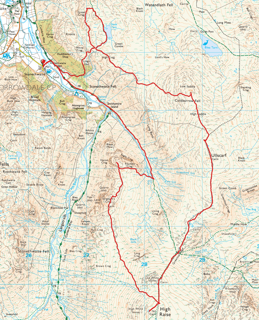
Striding Edge

A photo diary of Lake District fell walks

  • Dogs
  • Contact
  • Fells
    • Wainwrights
      • Eastern Fells
      • Far Eastern Fells
      • Central Fells
      • Southern Fells
      • Northern Fells
      • North Western Fells
      • Western Fells
      • Outlying Fells
    • Birketts
  • Information
    • About Striding Edge
    • Striding Edge
    • T&C’s
    • Privacy
    • Links
  • Walking Diaries
    • 2025 Walking Diary
    • 2024 Walking Diary

2015 Floods

Walked on 06/12/2015

I hoped I would never have to post photos like these again after the remarkably similar floods in 2009 but unfortunately I do and this is my small part of the story. The good people of Carlisle, Keswick, Cockermouth, Appleby and Kendal (and many places in between) fared much worse than we did in the south west  of Cumbria – my heart goes out to them all. Today’s photos are all iPhone photos sorry, that’s all I had.

IMG_1752

I took this one on Saturday afternoon on the way to Bowness - the River Leven looks high here but it does get higher as you will see later on.

IMG_1754

The reason for going to Bowness was to take sandbags and try to stem the flood waters - although not deep the water was running from the hillside behind then through the shop from back to front in this photo. The sandbags were in place to stop it going into the other half of the shop. Next door in Villa Positano was much worse, they had a full waterfall through the restaurant and next to them the Bodega Bar was also flooded right through. There was so much water coming through, they called the Fire Brigade to help pump it out.

IMG_1755

They only had a fleeting visit though - rightly enough they had bigger fish to fry tonight. Anyway, I had an interesting evening sweeping water from the shop until it seemed to subside enough for me to feel easy enough to leave it. I left for home via Windermere and across to Kendal as I thought it would be better on the main roads - hmm, let's just say my heart was in my mouth through Bannerigg and Ings! When I got to the A591 roundabout it was shut so there wasn't really a way to go. I cut across the top of Kendal and had a go along the Underbarrow road but just before Underbarrow the road was impassable to to deep flooding, even in our 4x4. Strangely enough, I was flagged down there by a paramedic who had been waiting for the MRT to pick her up for over an hour as she was supposed to be on duty in Kendal so of course the least I could do was take her there so that she could carry out the good work that was needed in and around Kendal. Kendal itself was completely blocked due to the flooding and not really fancying the journey back to Windermere in those conditions, there really was nowhere for me to go. The nearest option was to get a room at The Gateway Inn but (of course) there was no room at the inn. Kindly they let me and 20 other stranded motorists sleep in their bar area where they provided duvets etc so a great big thanks to them from me and the rest of the unexpected guests.

IMG_1760

Up at the crack of doom on Sunday and bolstered by tales of relatively flood free roads from the arriving staff at the inn, I headed back to Bowness to check out the shop hoping the damage was not too bad. Miracle of miracles - the shop was dry so after a couple of hours we managed to re-open as did the others affected by flooding on Ash Street, Bowness. I was however, mindful of all the people in Cumbria that have been affected by the flooding in their homes - it is tragic, just awful.

IMG_1757

The photos I took on the way home are all reminiscent of the 2009 floods, the water is just as high. at the time it was said that it could never happen again. I certainly did not expect to see water levels this high in my lifetime. This is Bowness with the lake so high it is up over the main road.

IMG_1758

The ticket offices for the ferry are under water as is the TIC (again) just out of view.

IMG_1762

The A592 just past the marina is blocked and there are a coupe, of cars that didn't make it. The rest of the A592 was like a cars graveyard, littered with those that did not make it through.

IMG_1763

Windermere marina.

IMG_1764

Flooded again.

IMG_1765

Down at Newby Bridge, I knew what to expect.

IMG_1767

The Swan Hotel under water.

IMG_1768

Newby Bridge and the River Leven.

IMG_1769

Anyone familiar with Kin Toffee Vodka that we sell in our shop? Well this is where it is made - I talked to Mick and Judith for a while and they were typically sanguine about it all with a 'business as usual' attitude from them. That is the Cumbrian spirit (in more ways than one)!

IMG_1771

At Backbarrow, the road is understandably closed.

IMG_1773

Once again the River Leven is over the bridge and the Whitewater Hotel is once again flooded...

IMG_1775

...as are the holiday lets.

IMG_1777

These two don't let a bit of water get in the way of a good ride on the east side of Coniston!

IMG_1779

The River Crake at Lowick - the tress show the normal line of the river. At least those downstream at Spark Bridge did not get flooded this time.


Stickle Pike

Walked on 27/11/2015

Start Point: Kiln Bank Cross (SD 215 933)

Kiln Bank Cross – Stickle Tarn – Stickle Pike – Kiln Bank Cross

Distance: 1 mile     Total Ascent: 105 metres     Time Taken: 30 minutes     Start Time: 09:10

Weather: Breezy, 10°C

The weather was really closed in and downright miserable this morning – we went to Stickle Pike with not too much hope of a dry walk but miraculously I reckon we got this done in the only dry half hour of the day. Always a nice jaunt up there though whatever the weather.

610_1898

Heck Fell across the valley.

610_1906

Stickle Tarn (spot the dogs?).

610_1909

The path to the summit - steeper and further than it looks in this photo.

610_1910

When I set off I could't even see Caw but when I looked behind the clouds had cleared to at least give a view.

610_1913

A similar view from close to the summit.

610_1915

Looking across to the main summit from the southern one...

610_1922

...and the other way to Great Stickle and the Duddon Estuary.

610_1931

Fletcher and Dougal.

610_1938

The main summit cairn.

610_1940

Caw and Stickle Tarn from the descent.

610_1941

The Duddon Valley, Harter Fell with its head in the clouds and Green Crag to the left.

610_1944

Ever had that sinking feeling? By the time we got down 5 minutes later the clouds had closed back in and the heavens opened - perfect timing Dougal!

Coniston Old Man and Brim Fell Rake

Walked on 25/11/2015

Start Point: Walna Scar road (SD 289 970)

Walna Scar car park – Boo Tarn – The Old Man of Coniston – Brim Fell – Brim Fell Rake – Boulder Valley – Walna Scar car park

Distance: 4 miles    Total Ascent: 647 metres     Time Taken: 5 hours     Start Time: 08:00

Weather: Wet and windy, clearing. 10°C

Today I had a walk with Clive Hutchby who is currently updating his 4th Wainwright Book ‘The Southern Fells’ – naturally I was keen to have a look at The Old Man and Brim Fell Rake with him as I have walked both once or twice in the past. The initially poor weather thankfully cleared up after a short while but the wind remained quite chilly at times. If you haven’t checked out the latest Wainwright book updates, they are fantastic and Clive has made a great job of bringing them bang up to date. Signed copies are available here (the cover photos are okay too 🙂 )

Brim-Fell-Rake

610_1743

What a dull start to the day with general murk and dreariness around. Looks like there is another shower heading our way across Little arrow Moor.

610_1748

Conditions were bad enough for us to get our waterproof gear on close to the start of the climb - we stopped below the small rocky knoll that is central in this photo (Limestone Haws).

610_1757

Come on, put 'em up!

610_1760

Buck Pike and Dow Crag across The Cove.

610_1765

An unexpected (but welcome) burst of sunshine.

610_1768

I think Dougal has seen another dog down there.

610_1773

Lost in it.

610_1774

Looking across to Brown Pike, Blind Tarn below.

610_1776

Clive climbing The Old Man route.

610_1790

Crepuscular rays over Coniston. We sat for a while and had a fine tasting brew near to where Angus and Casper ended up.

610_1798

A fine view across Low Water.

610_1803

Looking over to Wetherlam from the summit of The Old Man.

610_1807

Deserted Old Man summit.

610_1813

Heading for Brim Fell following the ridge.

610_1815

Looking back to The Old Man from Brim Fell.

610_1821

The Old Man from the start of the top section of Brim Fell Rake.

610_1827

It was a bit breezy here!

610_1830

Great How Crags.

610_1841

Suddenly, the sun is out over Levers Water.

610_1847

A similar but different view to Great How Crags.

610_1850

Dougal and Fletcher seem to enjoy the sunshine.

610_1861

On Raven Tor.

610_1866

The upper section of Brim Fell Rake.

610_1868

Heading for Low Water.

610_1873

The view over Boulder Valley from the lower section of Brim Fell Rake, taken from the opening of 'cave' on Brim Fell 3 - it is actually an old mine level.

610_1878

Fletcher and Dougal wondering where all the boulders are.

610_1881

Looking up to the lower section of Brim Fell Rake - the central grassy shelf running diagonally left down to right. It is steeper than it looks!

610_1883

Low Water Becks falls.

610_1892

The Pudding Stone.

610_1895

Old mine workings at Crowberry Haws.


Orrest Head

Walked on 22/11/2015

Start point: Windermere (SD 414 987)

Orrest Head (OF) from Windermere

Distance: 1.3 miles     Total Ascent: 105 metres     Time Taken: 45 minutes     Start Time: 15:30

Weather: Cold. 4ºC

Just time for a quick jaunt up to Orrest Head tonight to catch the dying embers of today’s winter sunshine. At least I remembered the camera and battery!

610_1648

Moon rising over the Howgills.

610_1651

The view over Windermere to the Langdale Pikes.

610_1667

The Far Eastern fells.

610_1687

The golden boys.

610_1706

Windermere sunset.

610_1712

The dying embers of the day.

610_1724

The Coniston fells.


Yewbarrow

Walked on 21/11/2015

Start Point: Overbeck Bridge (NY 168 068)

Overbeck Bridge – Bell Rib – Great Door – Yewbarrow (South Top) – Yewbarrow (North Top) – Dore Head – Over Beck – Overbeck Bridge

Distance: 3.9 miles     Total Ascent: 580 metres     Time Taken: 2 hours 30 minutes     Start Time: 08:30

Weather: Cold, windy on top, 2°C

There was a bit of a change in the weather today and it was completely different to the wet and windy weather of the last week – clear and bright with snow lying from around 300m. When I got to Wasdale, I stopped to take a couple of photos of the classic view but…there was no battery in my camera. Schoolboy error! Too late to go back so it was on with the walk anyhow, therefore I apologise if today’s photos are not up to the usual quality, they were taken with an iPhone (we still enjoyed the walk anyway!).

Yewbarrow-Map

IMG_1693

The Wasdale classic view.

IMG_1694

Bell Rib, Yewbarrow.

IMG_1695

Climbing towards the snow line.

IMG_1696

Looking across to Middle Fell.

IMG_1699

Wast Water from the steep climb.

IMG_1700

Great Door.

IMG_1701

Amen to this.

IMG_1702

A lovely view across to Lingmell, Scafell Pike and Scafell from the Yewbarrow ridge.

IMG_1703

Fun and frolics in the snow.

IMG_1706

Snowy Red Pike.

IMG_1708

Kirk Fell and Great Gable from the summit of Yewbarrow.

IMG_1711

Walking the ridge, Pillar to the left and distant Skiddaw ahead.

IMG_1714

Good job Fletcher and Dougal are all fur and fluff, the wind was chilly today.

IMG_1718

Kirk Fell and Great Gable.

IMG_1719

Looking towards Seatallan.

IMG_1720

Looking back towards the summit, the sun glinting on Burnmoor Tarn and the Irish Sea beyond.

IMG_1721

The Scafells.

IMG_1723

Kierk Fell from the edge of Stirrup Crag.

IMG_1724

Pillar above Mosedale.

IMG_1725

Dougal - The Lion King - contemplates the tricky descent to come.

IMG_1728

Made it! Down at Dore Head Tarn.

IMG_1729

Pillar from the same place.

IMG_1730

Stirrup Crag.

IMG_1731

A great view through to Sty Head.

IMG_1733

A penny for them Fletcher, heading back to Wasdale.

IMG_1735

Looking back to Dore Head, plenty of snow around today.

Black Fell

Walked on 13/11/2015

Start point: Knipe Fold (SD 391 994)

Black Fell from Knipe Fold

Distance: 3.4 miles     Total Ascent: 215 metres     Time Taken: 1 hour 15 minutes     Start Time: 09:30

Weather: Strong wind, frequent heavy showers. 6C

There has been lots of ‘weather’ around all week – rain, wind, hail – you name it. This morning didn’t seem so different when I set off in full waterproofs but I thought it didn’t turn out so bad in the end really…

01-Black-Fell.jpg-nggid0517151-ngg0dyn-0x0x85-00f0w010c010r110f110r010t010

610_1564

Hmmm, today didn't seem to be too promising. There were frequent heavy hail showers and the sky was duller than dull as I headed for the top of Black Fell.

610_1567

A dusting of snow on Helvellyn and Fairfield.

610_1571

...when I turned around I could hardly believe it! The wind had blown through the cloud and there was blue sky and the odd bit of sunshine around.

610_1574

Looking across to Bowfell and The Langdale Pikes.

610_1575

Sunshine on The Old Man.

610_1588

Looking back to Tarn Hows and Coniston Water.

610_1589

Where are we?

610_1591

Lingmoor Fell lit up by the sun.

610_1599

It was all I could do to stay upright the wind was so strong - here is a fleeting moment of sun and clouds that tells the story of the day quite well.

610_1601

The summit looking to Coniston.

610_1610

Close up on Helvellyn and Fairfield.

610_1618

What's the weather like Fletcher?

610_1624

Dougal takes it a little more regally than Fletcher.

610_1631

A wider view of the Eastern fells.

610_1633

The Fairfield Horseshoe.

610_1637

Drama over Windermere.

610_1642

The south east cairn.

Lake District autumn tour

Walked on 15/10/2015

To all the Striding Edge followers who wondered why I have ‘disappeared’ – an explanation! I have been really busy of late with work, shops etc so there have been quite a few walks, it is just that they haven’t made it onto the site yet. Most updates are done at the time on Facebook and Twitter where the photos are easier to upload at the time. The website, however, takes time so being strapped for it recently the posts have not quite made it onto here yet. Hopefully I will start working backwards from here to fill in some of the gaps.

Enough of that – this week the Autumn weather has been fantastic so today’s gallery is from a tour around some of the great places in the Lake District, hopefully shown off to best effect by the weather.

Book-Two-10-reasons-web

610_1474

Looking across Windermere to the Langdale Pikes.

610_1475

...and to the Coniston fells.

610_1479

Boats at Waterhead.

610_1484

Misty Derwent Water.

610_1487

A similar view from Friar's Crag.

610_1493

Friar's Crag.

610_1501-Edit

Catbells panoramic.

610_1513

High Crag and High Stile reflected in Buttermere.

610_1515

Haystacks and the pines.

610_1517

Similar but closer.

610_1520

Buttermere Pine reflections (this one found fame by being used on the national BBC weather the same evening!).

610_1535

Butter mere tree in the sunshine, looking towards Fleetwith Pike.

610_1548

Dougal and Fletcher were certainly enjoying the sunshine today.

Middle Fell

Walked on 14/10/2015

Start Point: Greendale (NY 144 056)

Greendale – Middle Fell – Greendale Tarn – Greendale Gill – Greendale

Distance:     3.2 miles     Total ascent: 525 metres     Time taken: 1 hour 45 minutes     Start time: 08:30

Weather: Warm and clear. 13°C

The fabulous weather from this week continued today and it was well worth a visit to Wasdale for a walk up to Middle Fell. The light was just perfect and with the colours really starting to show it made for a lovely morning to be walking the fells.

Middle-Fell

610_0341.jpg

Beautiful early light at Greendale.

610_0342.jpg

Buckbarrow and Casper Gully.

610_0344.jpg

The path and a straight up contrail.

610_0345.jpg

Looking back down - the sky suddenly clouded over for a while from here.

610_0350.jpg

A well earned drink on the climb. This pool always reminds me of Casper, a favourite watering hole of his.

610_0352.jpg

Scafells silhouette.

610_0354.jpg

...and from higher up, the sun lighting up Wast Water.

610_0359.jpg

The summit of Middle Fell.

610_0364.jpg

You may well be bigger than me you young pup but let's see your tongue!

610_0380.jpg

Looking towards the West Cumbrian coast.

610_0384.jpg

Haycock.

610_0385.jpg

Down at Greendale Tarn.

610_0387.jpg

Not quite warm enough for a swim today - the sunshine is deceptive as it was a cool wind.

610_0389.jpg

The descent alongside Greendale Gill.

610_0392.jpg

The classic view of Wasdale.

610_0394.jpg

Middle Fell.

Kelly Hall Tarn sunset

Walked on 12/10/2015

A few photos from a sunset walk around Kelly Hall Tarn on a lovely evening.

610_1254

Gorgeous colours at during the 'golden hour'.

610_1261

The Old Man reflected.

610_1268

Coniston Old Man close up.

610_1274

Looking good in the setting sun.

610_1280

Fletcher and Dougal.

610_1294

Kelly Hall Tarn sunset.

610_1304

The tarn from higher up.

610_1344

Lonesome Pine.

610_1357

Days end.

Coniston Old Man

Walked on 27/09/2015

Start point: Walna Scar road (SD 289 970)

Walna Scar car park – Boo Tarn – The Old Man of Coniston – Brim Fell – Brim Fell Rake – Low Water – Below Beck Fells – Walna Scar car park

Distance: 4.1 miles     Total Ascent: 630 metres     Time Taken: 1 hour 45 minutes     Start Time: 07:30

Weather: Bright, sunny and warm. 16C

What a gorgeous morning, the sun was certainly shining this morning and the fells were glowing with it – time for one of our favourites.

Coniston-Old-Man-Route-Map

610_1125

Sunrise over Coniston Water.

610_1127

Perfectly calm and a rising mist.

610_1128

The Bell.

610_1129

The Old Man.

610_1130

It was a gorgeous morning.

610_1133

Brown Pike ahead.

610_1134

Across The Cove to Dow Crag.

610_1135

Brown Pike and Blind Tarn.

610_1141

Fletcher and Dougal are leading the way.

610_1146

Looking across to Black Combe.

610_1149

The four of them (regular viewers will understand...).

610_1153

Looking down on the tourist path and Low Water from The Old Man.

610_1155

The Scafells from The Old Man summit.

610_1157

The weary traveller.

610_1165

Fletcher leads the way.

610_1167

Brim Fel is all ours this morning.

610_1171

Looking back to The Old Man.

610_1174

Swirl How with distant Skiddaw beyond and distant Blencathra to the right.

610_1176

Levers Water.

610_1178

Raven Tor.

610_1180

The Black Sail ridge and Wetherlam.

610_1190

Low Water reflections.

610_1192

Alright Fletchaaaa?

610_1200

Wetherlam across Boulder Valley.

610_1205

Reflected Coniston from the east side of the lake.

The Circuit of Devoke Water

Walked on 15/09/2015

Start point: Birker Fell road (SD 171 977)

Birker Fell Road – Rough Crag (Birker Moor) (OF) – Water Crag (OF) – White Pike on Birkby Fell (OF) – Yoadcastle (OF) – Woodend Height (OF)– Seat How (Birker Moor) (OF) – Birker Fell Road

Distance: 5.4 miles     Total Ascent: 686 metres     Time Taken: 2 hours

Weather: Cloudy but warm. 17oC.

It’s a long time since I completed this circuit (8 years!) but I quite fancied it today – the going is relatively easy and it is certainly quiet with decent views all around. This one comes well recommended…

Circuit-of-Devoke-Water

Firtsly, the Tour of Britain cycle race visited Cumbria on Thursday 10th September so it seemed rude not to visit – we actually saw it in two places, the climb from Plumpton and then later on the climb from Langwathby. Excellent weather for an excellent afternoon’s viewing.

610_1047

Here come the leaders.

610_1052

The Sky train.

610_1066

Sir Bradley leads the peloton. On with today's walk...

610_1081

Heading for Rough Crag.

610_1082

Sunlight on Devoke Water, beyond is Woodend Height.

610_1083

On Rough Crag.

610_1089

Looking towards Water Crag, the next port of call.

610_1094

There was an ear raising breeze on the top.

610_1096

Looking back to Rough Crag.

610_1100

Seat How with Harter Fell beyond.

610_1102-Edit

A panorama of Devoke Water.

610_1109

White Pike summit looking out to the coast.

610_1111

The view from Yoadcastle...

610_1113

...and from nearby Woodend Height.

610_1118

The boathouse with Rough Crag beyond.

610_1122

The wind is picking up as shown by the ripples across Devoke Water, photo from Seat How.

610_1123

The cairn on Seat How.

Walla Crag

Walked on 01/09/2015

Start point: Love the Lakes, Keswick (NY 266 233)

Love the Lakes, Keswick – Springs Road – Springs Wood – Rakefoot – Walla Crag – Derwent Water – Love the Lakes, Keswick

Distance: 4.9 miles      Total Ascent: 322 metres     Time Taken: 2 hours     Start Time: 10:00

Weather: Overcast but warm. 17°C

Today I took the opportunity for a relatively quick walk from Keswick (in between shop stock deliveries!) up to Walla Crag. Although dull to start with, the weather was ever improving throughout the walk. This walk will feature in a future edition of Trail magazine.

Walla-Crag

610_0955-Edit

A lovely view across Windermere on the way to Keswick.

610_0964

Blencathra from the climb to Walla Crag.

610_0967

Skiddaw and Keswick from the plateau.

610_0971

Lots of heather in bloom.

610_0972

Looking towards Bassenthwaite Lake.

610_0976

Dougal and Fletcher in the Ling.

610_0983

Derwent Water.

610_0995

Two youngsters try and work out the fells in view.

610_1003

Bleaberry Fell clad in purple.

610_1007

The Cat Gill descent.

610_1011

Catbells.

610_1017

The Millennium Stone.

610_1022

Fletcher works out how he can get the two halves together.

610_1031

Friar's Crag.

610_1034

Clearing skies.

Brock Barrow

Walked on 17/08/2015

Start Point: High Nibthwaite (SD 294 897)

Brock Barrow from High Nibthwaite

Distance: 1.5 miles     Total Ascent: 175 metres     Time Taken: 40 minutes     Start Time: 17:00

Weather: Warm and sunny. 18°C

Time for a late afternoon walk up to Brock Barrow after a fabulous day of sunny weather – there are great views from up there on a day such as this.

610_0902

Peek-a-boo in the high bracken, Brock Barrow ahead.

610_0904

...and again on the ascent.

610_0906

Looking across allan Tarn at the southern end of Coniston Water.

610_0918

Fletcher - feeling in the pink.

610_0923

The Coniston fells from the summit cairn.

610_0926-Edit

A panorama of the Coniston fells.

610_0938

Brothers in arms - Dougal and Fletcher.

610_0942

It\'s a beautiful evening.

610_0945

The view from the secondary summit.

Beacon Fell

Walked on 03/08/2015

Start Point: At the end of the minor road from Brown Howe (SD 281 916)

Beacon Fell (OF) from Tottle Bank

Distance: 2 miles     Total Ascent: 200 metres     Time Taken: 1 hour 15 minutes     Start Time: 13:30

Weather: Warm but overcast. 17°C

I went with Connie and the dogs to check out our old favourite Beacon Fell – the treasure tin is still there in the cairn which was good to see. I was surprised there was no one else around up there today, the lower fells always appeal more during the school holidays. As ever, the sun came out as we reached the car at the end…

Beacon-Fell

610_0812

All is green - and grey - looking to the Coniston fells.

610_0815

Dougal and Fletcher climb the gully.

610_0819

Looking back down the gully to Coniston Water.

610_0820

The same view from a little higher up.

610_0822

Dougal, Fletcher and Connie on Beacon Fell. The treasure tin was still in situ!

610_0835

The Coniston fells from Beacon Fell.

610_0837

Coniston Water.

610_0838-Edit

A panorama from the summit.

610_0842

The swimmers in Beacon Tarn.

610_0847

The Fletching.

610_0852

The Old Man and Wetherlam.

Loweswater Fells

Walked on 09/07/2015

Start point: Maggie’s Bridge, Loweswater (NY 134 210)

Maggie’s Bridge – High Nook Farm – High Nook on Gavel Fell – Gavel Fell – Blake Fell – Burnbank Fell – Holme Wood – Watergate Farm – Maggie’s Bridge

Distance:     6.2 miles     Total Ascent: 600 metres     Time Taken: 3 hours 30 minutes     Start Time: 08:15

Weather: Sunny and warm. 10C

What a fantastic summer’s day for a walk over the Loweswater fells – the sun was shining, the birds were singing (the dogs were barking!) – I really enjoyed this one. It was such a great early morning I called in at a few well known beauty spots for one or two photos…

610_0626

Early morning down at Derwent Water.

610_0628

A panorama across calm waters.

610_0634

A seat with a view at Friar's Crag.

610_0642

The view from Friar's Crag.

610_0651

Catbells.

610_0660

The jaws of Borrowdale (with incoming duck!).

610_0663

Ashness Jetty.

610_0669

Skiddaw.

610_0671

Asheness Jetty portrait.

610_0678

Ashness Bridge.

610_0686

Surprise View.

610_0694

Buttermere.

610_0717

The Buttermere Pines.

Loweswater Fells

The Loweswater Fells route map.

610_0721

Gavel Fell ahead from the track to High Nook Farm.

610_0722

Climbing above High Nook Tarn.

610_0725

Looking back to Low Fell across Loweswater.

610_0726

Big cloud over Grasmoor and Whiteside, Mellbreak on the near right.

610_0729

High over High Nook Tarn.

610_0734

Dougal has found the nearest available bog to cool down!

610_0736

The subsidiary summit of High Nook on Gavel Fell.

610_0743

Gavel Fell summit.

610_0745

Fletcher and Dougal enjoying the sunshine.

610_0754

Heading for Blake Fell.

610_0760

A fine view to Grasmoor from Blake Fell.

610_0762

Knock Murton and Cogra Moss from Blake Fell.

610_0766

Criffel across the Solway Firth.

610_0768

Burnbank Fell summit.

610_0777

The fantastic terrace path above Loweswater.

610_0778-Edit

Loweswater panorama.

610_0781

A seat with a view #2.

2016-cover

2016 Calendar cover - coming soon.

610_0788

Dougal has found a good use for it!

610_0794

Holme Force.

610_0800

A peek through the trees at the upper section.

610_0804

Back down at Loweswater shore.

The Dodds

Walked on 23/06/2015

Start Point: Dockray (NY 393 215)

Dockray – High Row – Randerside – Great Dodd – Watson’s Dodd – Stybarrow Dodd – White Stones on Green Side – Hart Side – Birkett Fell – Brown Hills – Swineside Knott – Watermillock Common – Common Fell – Dockray

Distance:     10.3 miles     Total Ascent: 732 metres     Time Taken: 4 hours    Start Time: 10:00

Weather: Warm and hazy. 19°C

It’s not so long ago that I did this walk (back in January) but I wanted to have another walk around to check notes as this will be a featured walk soon in Trail magazine. It was really quite warm today, shorts and t-shirt all the way.
The-Dodds

The Dodds Route Map

610_0531

On the 11th June, there was a celeb visit to Love the Lakes, Keswick. Chemmy Alcott, Olympic skier, is the brand ambassador for The Lakes Distillery and was on a promotional visit to our shop. She seemed to get on well with Dougal and Fletcher!

610_0545

Sing Fletcher. sing!

610_0553

Promo shot - Chemmy, Louise and Katie (Lakes Distillery). If you like a drop of gin this is highly recommended!

610_0556

Later that day at Bassenthwaite it was absolutely boiling so the boys were keen to get in for a dip. On with the walk...

610_0558

Climbing the road out of Dockray.

610_0559

Looking across to today's target.

610_0563

Sheep spotting.

610_0567-Edit

Great Dodd from Randerside.

610_0572

A hazy view to Keswick from Great Dodd summit.

610_0573

Heading for Watson's Dodd to the right then Stybarrow Dodd to the left.

610_0585

Looking back to Great Dodd from Watson's Dodd.

610_0591

Who's the King of the Castle on Watson's Dodd summit?

610_0593

Watson's and Great from the climb to Stybarrow (Dodd!)

610_0595

On Stybarrow Dodd, Catstycam and Helvellyn in the distance.

610_0604

On Hart Side looking to White Stones on the left and Stybarrow Dodd to the right.

610_0605

The proud cairn on Birkett Fell looking to Ullswater.

610_0608-Edit

A panoramic view of Ullswater from Brown Hills.

610_0613

When push comes to shove!

610_0618

Looking to Patterdale and the head of Ullswater.

Birks

Walked on 09/06/2015

Start point: Patterdale (NY 394 160)

Patterdale – Thornhow End – Black Crag – Birks – Trough Head – Arnison Crag – Patterdale Hotel – Patterdale

Distance: 3.7 miles     Total Ascent: 515 metres     Time Taken: 1 hour 30 minutes     Start Time: 10.30

Weather: Changeable but dry. 7ºC

The weather turned out to be one of the poorer days in the middle of a stunning week this week…but you have to take your opportunities when you can so that’s what we did when we had a short walk up to two of the smaller fells at the head of Ullswater.

Glenamara-Park

Birks Route Map

610_0480

A brief glimmer of sunshine at the start of the walk looking to Thornhow End.

610_0484

Walking through the sylvan landscape.

610_0488

Looking back to Ullswater and Place fell.

610_0489

St. Sunday ahead.

610_0499

It's all tongues for Fletcher and Dougal.

610_0500

The summit of Birks.

610_0504

There is a great view across to the Far Eastern fells descending to Trough Head from Birks. Here we found a bright red tennis ball sized ball - Fletcher must have gone up and down 20 times chasing it.

610_0509

The approach to Arnison Crag.

610_0511

The summit of Arnison Crag.

610_0527

The descent to Patterdale.

Red Screes

Walked on 27/05/2015

Start point: Kirkstone Pass (NY 401 080)

Red Screes from Kirkstone Pass

Distance: 1.4 miles     Total Ascent: 330 metres     Time Taken: 35 minutes     Start Time: 10:50

Weather: Dull and cool, 14°C

Time for a quick walk this morning but the weather was not too kind…or too summery at all this morning!

610_0455

Red Screes from Kirkstone Pass.

610_0460

On the summit of Red Screes - 20 minutes to get here according to the camera.

610_0462

Fletcher and Dougal enjoying the run out.

610_0467

The summit tarn.

610_0474

Looking down on the Kirkstone Pass Inn.

610_0479

The steep way down - and a glimpse of Windermere.


Orrest Head

Walked on 24/05/2015

Start point: Windermere (SD 414 987)

Orrest Head (OF) from Windermere

Distance: 1.3 miles     Total Ascent: 105 metres     Time Taken: 30 minutes     Start Time: 09:20

Weather: Warm. 18ºC

Time for a quick jaunt up to Orrest Head before lunch, ascending the back way is much better than via the usual signposted path – it was a very pleasant wander on an early summer day.

610_0407-Edit

A view along Windermere from Fell Foot, taken on 13th May.

610_0415

Looking across the rooftops of Windermere on the way to Orrest Head.

610_0418

A similar view from higher up.

610_0422

Bluebells in the wood.

610_0427

Looking to the high fells from the viewpoint indicator.

610_0432

The Far Eastern fells.

610_0437

A fabulous view along Windermere.

610_0448

Tongues out! These boys are telling you it is warm today.

Middle Fell

Walked on 01/05/2015

Start Point: Greendale (NY 144 056)

Greendale – Middle Fell – Greendale Tarn – Greendale Gill – Greendale

Distance: 2.8 miles     Total ascent: 525 metres     Time taken: 1 hour 30 minutes     Start time: 07:15

Weather: Lovely. 5°C

What a fabulous morning it was with really clear air and that ‘good to be alive’ feeling. We had time for a quick walk up to well trodden (by us) Middle Fell, the views from there of the Scafells and the head of Wasdale are simply fantastic.

Middle Fell

610_0341.jpg

Beautiful early light at Greendale.

610_0342.jpg

Buckbarrow and Casper Gully.

610_0344.jpg

The path and a straight up contrail.

610_0345.jpg

Looking back down - the sky suddenly clouded over for a while from here.

610_0350.jpg

A well earned drink on the climb. This pool always reminds me of Casper, a favourite watering hole of his.

610_0352.jpg

Scafells silhouette.

610_0354.jpg

...and from higher up, the sun lighting up Wast Water.

610_0359.jpg

The summit of Middle Fell.

610_0364.jpg

You may well be bigger than me you young pup but let's see your tongue!

610_0380.jpg

Looking towards the West Cumbrian coast.

610_0384.jpg

Haycock.

610_0385.jpg

Down at Greendale Tarn.

610_0387.jpg

Not quite warm enough for a swim today - the sunshine is deceptive as it was a cool wind.

610_0389.jpg

The descent alongside Greendale Gill.

610_0392.jpg

The classic view of Wasdale.

610_0394.jpg

Middle Fell.

  • « Previous Page
  • 1
  • …
  • 3
  • 4
  • 5
  • 6
  • 7
  • …
  • 53
  • Next Page »