Striding Edge

A photo diary of Lake District fell walks

  • Walks
  • Fells
    • Wainwrights
      • Eastern Fells
      • Far Eastern Fells
      • Central Fells
      • Southern Fells
      • Northern Fells
      • North Western Fells
      • Western Fells
      • Outlying Fells
    • Birketts
  • Dogs
  • Love The Lakes
  • Contact

Birks

Walked on 09/06/2015

Start point: Patterdale (NY 394 160)

Patterdale – Thornhow End – Black Crag – Birks – Trough Head – Arnison Crag – Patterdale Hotel – Patterdale

Distance: 3.7 miles     Total Ascent: 515 metres     Time Taken: 1 hour 30 minutes     Start Time: 10.30

Weather: Changeable but dry. 7ºC

The weather turned out to be one of the poorer days in the middle of a stunning week this week…but you have to take your opportunities when you can so that’s what we did when we had a short walk up to two of the smaller fells at the head of Ullswater.
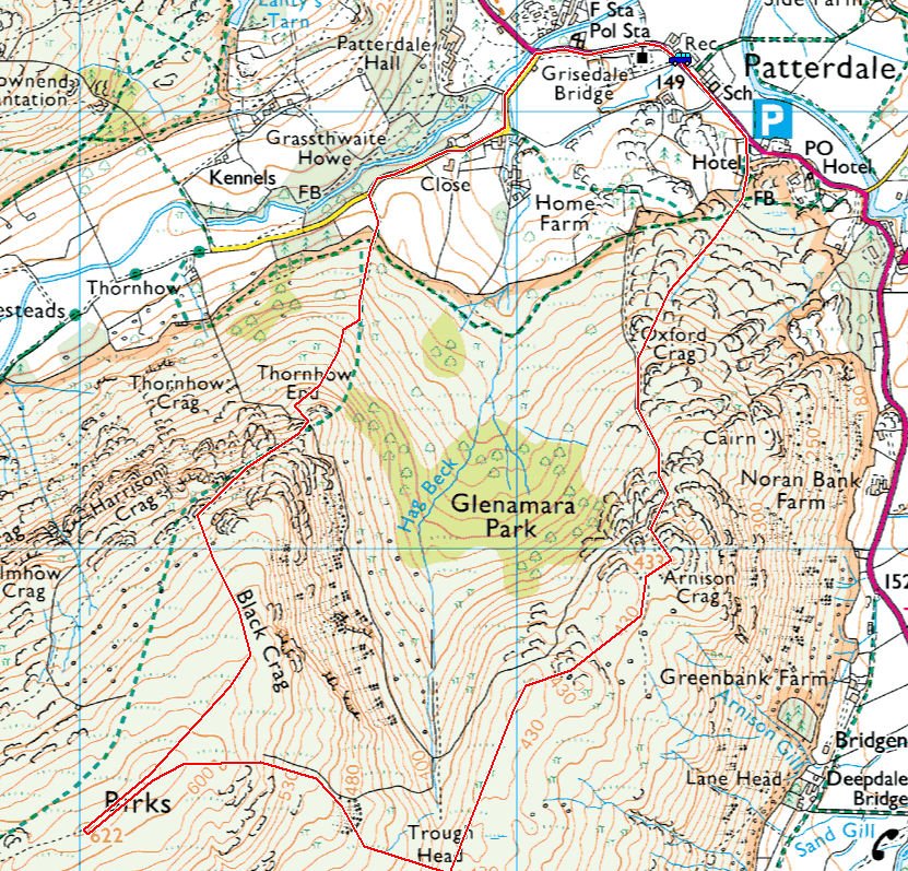
Glenamara-Park

Birks Route Map

610_0480

A brief glimmer of sunshine at the start of the walk looking to Thornhow End.

610_0484

Walking through the sylvan landscape.

610_0488

Looking back to Ullswater and Place fell.
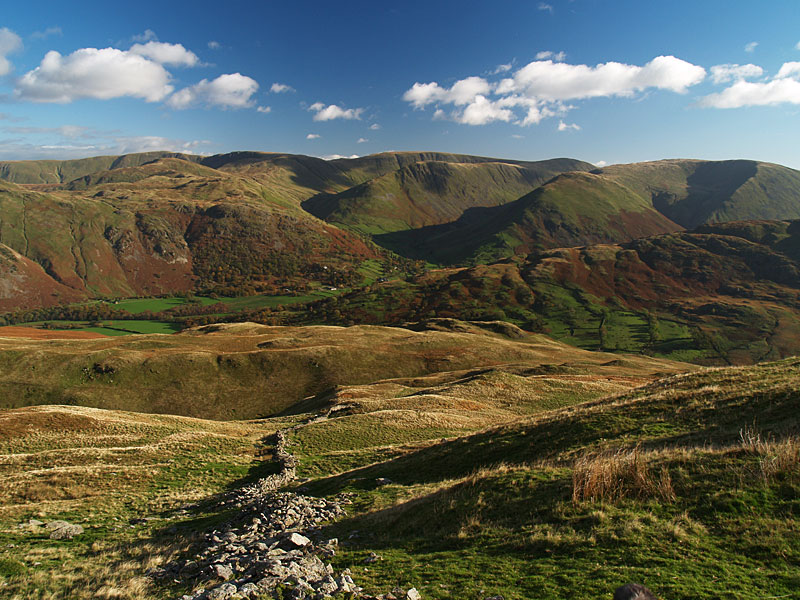
610_0489

St. Sunday ahead.

610_0499

It's all tongues for Fletcher and Dougal.

610_0500

The summit of Birks.

610_0504

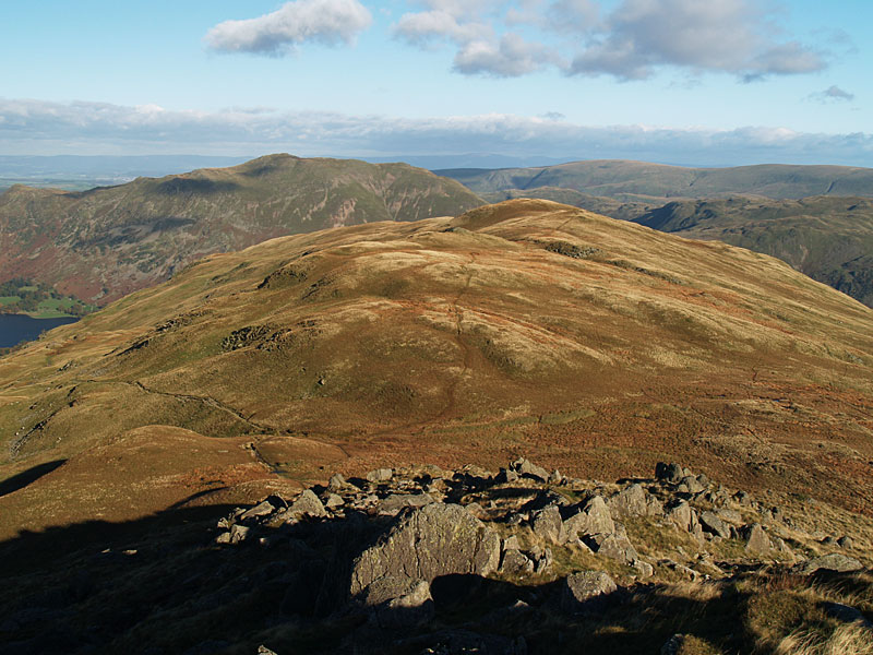
There is a great view across to the Far Eastern fells descending to Trough Head from Birks. Here we found a bright red tennis ball sized ball - Fletcher must have gone up and down 20 times chasing it.

610_0509

The approach to Arnison Crag.

610_0511

The summit of Arnison Crag.

610_0527

The descent to Patterdale.

Birks

Height: 622 metres / 2041 feet Grid reference: NY 38177 14486 Category: The Eastern Fells

Birks

Birks

Hartsop on the descent from Birks

Hartsop on the descent from Birks

Grisedale Horseshoe

Walked on 12/10/2010

Start point: Patterdale (NY 394 160)

Patterdale – Hole-in-the-Wall – Striding Edge – Helvellyn – Nethermost Pike – High Crag – Dollywaggon Pike – Seat Sandal – Deepdale Hause – Saint Sunday Crag – Birks – Patterdale

Distance: 11 miles     Total Ascent: 1419 metres    Time Taken: 6 hours     Start Time: 06:45

Weather: Sunny and clear. 13C

I was up early this morning to make the most of the expected good weather to come for the day. I wasn’t disappointed and it turned into a fantastic and memorable day on the fells with incredible clarity and an inversion over the Lake District as well. When I set off from Patterdale this morning (in the dark!), the temperature gauge was showing -1C but once the sun rose it was really warm and I ended up completing the walk in shirt sleeves.

Grisedale

Grisedale route map.

12.10.10-003

It was below freezing when I left Patterdale and pretty chilly climbing to the Hole-in-the-Wall, here looking back towards Patterdale with Ullswater under the early morning mist.

12.10.10-019

It was below freezing when I left Patterdale and pretty chilly climbing to the Hole-in-the-Wall, here looking back towards Patterdale with Ullswater under the early morning mist.

12.10.10-031

Sun rising but not visible here yet. That mist is following me up the valley below.

12.10.10-040

The sun rising over High Street.

12.10.10-042

All a-glow heading for the Hole-in-the-Wall.

12.10.10-048

Beautiful sunrise and the inversion has flooded into Grisedale.

12.10.10-052

Climbing the steep section of the path.

12.10.10-055

Looking to Birkhouse Moor from the Hole. All the low lying ground to the east is covered with mist.

12.10.10-061

Helvellyn and Catstycam at dawn.

12.10.10-066_stitch

A panoramic view.

12.10.10-073

Looking back from the climb to High Spying How.

12.10.10-082

Even the normally dull as ditchwater Great Mell Fell looks good today, taking on a special interest in the inversion.

12.10.10-084

The Mell Fells and Gowbarrow Fell rise from the mist, Sheffield Pike in the foreground.

12.10.10-087

The mighty Striding Edge.

12.10.10-091

Flat calm Red Tarn.

12.10.10-096

The view from High Spying How.

12.10.10-103

Crossing The Edge.

12.10.10-116

Red Tarn and Catstycam.

12.10.10-121s

Panoramic Red Tarn.

12.10.10-136

Looking down on Striding Edge.

12.10.10-142

There is a big inversion to the south too looking over the cross shelter. In fact the whole Lake District is surrounded by the inversion.

12.10.10-147

The view from the summit of Helvellyn.

12.10.10-157

Dougal and Casper on the summit.

12.10.10-166

The 'Isle of Skiddaw', the Vale of Keswick is beneath the cloud somewhere.

12.10.10-168s

A panoramic view of the Vale of Keswick.

12.10.10-174

Swirral Edge and Catstycam, the Pennines beyond Ullswater.

12.10.10-178

Cross Fell beyond Ullswater.

12.10.10-184

Looking into the bright sunshine from Helvellyn.

12.10.10-192

Looking to the south west from the path to Nethermost Pike. That distant fell (Black Combe), in solitary peeping out in the clouds intrigued me - I wonder what it would be like to be stood on the top of it? Actually, I have had a similar experience on Hard Knott with Connie (here) and you never know whether you will actually ever get above the cloud.

12.10.10-197

All clear over Bowfell, Scafell and Great Gable.

12.10.10-201

Striding Edge.

12.10.10-203

Misty Grisedale.

12.10.10-215

The view from Nethermost Pike.

12.10.10-220

Casper takes it easy heading for Dollywaggon Pike.

12.10.10-224

The Solway Firth is also under inversion between Robinson and Grasmoor to the north.

12.10.10-232

Dollywaggon Pike from the steep climb to Seat Sandal.

12.10.10-233

Thirlmere under cloud and Skiddaw from Seat Sandal.

12.10.10-234

The Vale of Grasmere.

12.10.10-236

Thirlmere

12.10.10-248

Saint Sunday Crag and Fairfield from the descent of Seat Sandal.

12.10.10-253

Seat Sandal from the start of the climb to Fairfield.

12.10.10-255

I took the path to Deepdale Hause which turned out to be a good one to get to Saint Sunday, well worth a go. It was cold along here though in the shade looking down on Grisedale Tarn.

12.10.10-260

Seat Sandal and Grisedale Tarn.

12.10.10-265

Fairfield and Cofa Pike from Deepdale Hause.

12.10.10-268

Dollywaggon Pike across Grisedale.

12.10.10-274

Looking west from the climb to Saint Sunday Crag.

12.10.10-276

The Helvellyn ridge.

12.10.10-280

The summit of Saint Sunday Crag.

12.10.10-283

Heading for Birks below, Place Fell beyond.

12.10.10-288

Dougal and Casper on Birks.

12.10.10-289

Looking back to Saint Sunday from Birks.

12.10.10-303

On the edge of heaven?

12.10.10-309

Ullswater panoramic.

12.10.10-314

Place Fell.

Glenamara Park

Walked on 08/12/2009

Start point: Patterdale (NY 394 160)

Patterdale – Thornhow End – Black Crag  – Birks – Trough Head – Arnison Crag – Patterdale Hotel – Patterdale

Distance: 3.7 miles    Total Ascent: 515 metres     Time Taken: 1 hour 30 minutes

Weather: Changeable but dry. 7ºC

Today was another ‘Dougal length’ walk as I am mindful that he is still only a pup and we can’t go too far just yet, eager though he may be! We had a walk around Glenamara Park taking in Birks and Arnison Crag and the weather started off clear enough but there were soon ominous looking clouds around blown in by the strong wind which proved to be a real cold blast.

Glenamara Park

Glenamara Park route map.

08.12.09-011

Thornhow End from the foot of the climb.

08.12.09-012

The first view of Ullswater from the climb through the trees.

08.12.09-013

Place Fell is on fire.

08.12.09-015

The view to Glenridding and Ullswater from the climb.

08.12.09-017

Ullswater with Great Mell Fell and Gowbarrow Park beyond.

08.12.09-018

Place Fell across Patterdale.

08.12.09-019

High Spying How - the start of Striding Edge - and Birkhouse Moor across Grisedale.

08.12.09-023

The sun is trying to burn through the clouds looking across to Arnison Crag.

08.12.09-026

The boys take an alternative path on this steep section.

08.12.09-028

Bleaberry Crags and the wall of 'Hole-in-the-Wall' fame with the pointed Catstycam in view.

08.12.09-039

Ullswater and Place Fell from the start of the Birks summit plateau.

08.12.09-041

I think Dougal and Casper are playing 'catch one kiss one' on the way to Birks summit!

08.12.09-053

Birks with Saint Sunday Crag covered in ominous looking clouds behind.

08.12.09-056

Nethermost Pike and Helvellyn are under there somewhere.

08.12.09-061

There is an arctic blast and heavy clouds now at the start of the descent towards Arnison Crag, here looking across to Hartsop.

08.12.09-067

Arnison Crag from the steep descent alongside the wall. I left it at the bottom right corner to follow the top of the ridge.

08.12.09-069

Ullswater from Trough Head.

08.12.09-071

Looking back to Gavel Pike and Saint Sunday Crag.

08.12.09-074

Birks and the wall.

08.12.09-076

Arnison Crag ahead, Place Fell beyond.

08.12.09-081

A bit of sunshine again over Hartsop Dodd.

08.12.09-085

Birks from Arnison Crag.

08.12.09-095

'Tonight Matthew I'm going to be Angus'. Dougal does a good impression of the old boy in the strong wind.

08.12.09-102

Dougal and Casper on Arnison Crag.

08.12.09-107

You can see how strong the wind is now by the ripples on Ullswater.

08.12.09-108

Hartsop from Arnison Crag.

08.12.09-114

Descending alongside the wall.

08.12.09-116

Glenridding and Glenridding Dodd.

Glenamara Park

Walked on 06/03/2007

Start point: Grisedale Bridge (NY 390 161)

Grisedale Bridge – Birks – Arnison Crag – Patterdale – Grisedale Bridge

Distance: 3.5 miles   Total Ascent: 520 metres     Time Taken: 1 hour 30 minutes

Weather: Overcast. 10oC.

It was a bit grey and damp for a short walk circling Glenamara Park above Patterdale, but at least it wasn’t raining after the downpour of last night. Everywhere was very wet though and the wind on the tops was quite chilly with only brief glimpses of sunshine to provide some cheer.

Glenamara Park

06.03.07-004

The steep path to Birks from Glenamara Park.

06.03.07-013

There was an occasional touch of blue sky to the north-west, here looking to Ullswater from the climb to Birks.

06.03.07-020

Place Fell.

06.03.07-043

Time for a rest for Angus and Casper.

06.03.07-050

The breeze picked up as we got higher - Casper has spotted something in Grisedale Valley below.

06.03.07-061

Saint Sunday Crag with some stubborn snow still lingering, Dollywagon Pike and Nethermost Pike to the right.

06.03.07-067

Gavel Pike and Saint Sunday Crag from the summit of Birks, Hart Crag to the left.

06.03.07-072

Descending by the broken wall to Trough Head with the Arnison Crag ridge in the centre.

06.03.07-076

Arnison Crag and Place Fell.

06.03.07-082

Looking back to a prominent Gavel Pike and Saint Sunday Crag.

06.03.07-089

Ullswater from Arnison Crag.

06.03.07-091

Place Fell from the summit of Arnison Crag.

06.03.07-092

There was lots of rain last night - the fields south of Patterdale are flooded, as are many parts of the road.

06.03.07-098

Sunshine across Deepdale. Hartsop Dodd beyond the Hartsop above How ridge.

06.03.07-101

Hartsop Dodd, Caudale Moor beyond.

06.03.07-106

Ullswater from the descent to Patterdale.

06.03.07-114

Birks across Glenamara Park.

Deepdale Horseshoe

Walked on 01/11/2006

Start point: Deepdale Bridge (NY 399 144)

Deepdale Bridge – Gale Crag – Hartsop Above How – Hart Crag – Fairfield – Cofa Pike – Saint Sunday Crag – Gavel Pike –  Birks – Arnison Crag – Deepdale Bridge

Distance: 10.3 miles     Total Ascent: 1431 metres     Time Taken: 4 hours 45 minutes

Weather: Clear and cold, especially on the highest tops. 9oC.

After a cold and frosty night, it was a really clear day today with lovely blue skies and autumnal colours all around Deepdale. The Hartsop above How ridge is a fine walk and the return across Fairfield and St. Sunday Crag makes a lovely circuit of the valley. Angus and Casper managed to get recognised again on St. Sunday Crag by a StridingEdge fan, and (by default) so did I!

01 Deepdale Horseshoe

01.11.06-001

Autumnal Deepdale at the start of the walk.

01.11.06-005

Gavel Pike on St. Sunday Crag from the Hartsop above How ridge.

01.11.06-014

St. Sunday Crag across Deepdale.

01.11.06-016

Looking back to Place Fell.

01.11.06-018

Angletarn Pikes.

01.11.06-021

St. Sunday Crag.

01.11.06-025

Onward and upward - looking back to Place Fell and Angletarn Pikes.

01.11.06-030

Looking along the ridge to Hart Crag and Fairfield.

01.11.06-040

Angus.

01.11.06-052

A pair of Beardies on Hartsop above How. Down below in Dovedale, I could see foxhounds and hear the constant shouts and blowing horn of the huntsmen. Not sure what they hunt these days, though!

01.11.06-061

Looking across an icy pool to Hart Crag and Fairfield.

01.11.06-063

Fairfield.

01.11.06-072

Looking down the Hartsop above How ridge from Hart Crag.

01.11.06-076

Shooting into direct sunlight, not a good idea - but I liked the way the sun lit up Windermere and Morecambe Bay from Hart Crag.

01.11.06-079

The summit of Hart Crag.

01.11.06-092

The western fells from Fairfield, the familiar shape of Great Gable to the left.

01.11.06-094

...and a wider panorama.

01.11.06-100

Great Gable.

01.11.06-103

Looks busy over on Helvellyn.

01.11.06-111

Dollywagon Pike, Nethermost Pike and Helvellyn across Grisedale.

01.11.06-116

Cofa Pike and St. Sunday Crag.

01.11.06-123

Seat Sandal above Grisedale Tarn and the view westwards beyond from Cofa Pike.

01.11.06-141

Dollywagon Pike.

01.11.06-150

The summit of St. Sunday Crag - it's starting to cloud a bit now.

01.11.06-153

Gavel Pike and the Far Eastern fells from St. Sunday Crag. I could hear the bellowing of stags somewhere down below from here.

01.11.06-159

Ullswater and Birks from Gavel Pike.

01.11.06-161

Birks.

01.11.06-168

Hartsop on the descent from Birks.

01.11.06-170

Ullswater and Great Mell Fell from Trough Head.

01.11.06-174

Hartsop from the summit of Arnison Crag.

01.11.06-179

Just the three of us here on Arnison Crag.

01.11.06-189

Place Fell and Autumn in Deepdale.

Fairfield

Walked on 12/04/2005

Start point: Cow Bridge, Hartsop (NY 403 134)

Cow Bridge – Gale Crag (322) – Hartsop Above How (323) – Hart Crag – Fairfield – Cofa Pike – Saint Sunday Crag –Gavel Pike – Birks (324) – Arnison Crag (325) – Cow Bridge

Distance: 9.7 miles     Total Ascent: 1385 metres     Time Taken: 4 hours

Weather: Sunny with a strong breeze. 8oC in the valley rising to 12oC. Icy cold on the tops.

I had a great high level ridge walk today along the Hartsop above How ridge, up to Hart Crag and Fairfield and then back down along the Saint Sunday ridge. It was a pleasant surprise to see the sunshine, but it was deceptively cold on the tops with a bitter wind blowing. With hindsight I would have been better off starting and finishing at Deepdale Bridge and walking the full Hartsop above How ridge.

Fairfield

Fairfield route map.

Elevation

Elevation profile of the route.

Fairfield 3D

3D image of the walk route.

Fairfield - 12th April 005

Caudale Moor, Kirkstone Pass and Red Screes in early sunlight from the steep ascent to the Hartsop Above How ridge.

Fairfield - Panorama1_small

Hartsop Dodd over Brothers Water. To the left are Gray Crag and High Street.

Fairfield - 12th April 014

Place Fell from Gale Crag summit. Great Mell Fell can be seen to the left.

Fairfield - Panorama2_small_annotated

The view along the ridge from the summit of Hartsop above How.

Fairfield - 12th April 021

Dove Crag.

Fairfield - 12th April 026

Looking back along Hartsop above How from Hart Crag.

Fairfield - 12th April 029

The view from Rydal Head. Windermere, Esthwaite Water and Coniston Water are all visible.

Fairfield - Panorama3_small

Fairfield summit.

Fairfield - 12th April 041

Cofa Pike to the left and Saint Sunday Crag.

Fairfield - Panorama4_small

Grisedale Tarn and the Dollywagon Pike - Nethermost Pike - Helvellyn ridge.

Fairfield - 12th April 052

Striding Edge and Helvellyn from Saint Sunday Crag. The peak of Catstycam is to the right, then Raise and the Dodd's.

Fairfield - 12th April 058

Gavel Pike and Saint Sunday Crag from Birks.

Fairfield - 12th April 064

Ullswater from Arnison Crag.

Fairfield - 12th April 070

Arnison Crag.

Helvellyn

Walked on 07/11/2003

Patterdale – Birkhouse Moor (140) – Striding Edge – Helvellyn – Nethermost Pike (141) – Dollywaggon Pike (142) – Seat Sandal (143) Fairfield – Cofa Pike – Saint Sunday Crag – Birks – Patterdale

013.JPG
014.JPG
015.JPG
016.jpg
017.JPG
018.JPG
019.JPG
020.JPG
021.jpg
022.JPG
023.jpg
024.JPG
025.JPG
026.JPG
027.JPG

Fairfield

Walked on 12/06/2003

Ambleside – Nab Scar (39) – Heron Pike (40) – Stone Arthur (41) – Great Rigg (42) – Fairfield (43) – St Sunday Crag (44) – Birks (45) – Patterdale – Kirkstone Pass – Ambleside

Dsc00431

Windermere from the ascent of Nab Scar.

Nab Scar

Nab Scar summit.

Heron Pike

Hart Crag and High Pike from Heron Pike summit.

Dsc00446

The Fairfield Ridge from Heron Pike.

Stone Arthur

Stone Arthur summit.

Dsc00447

Grasmere from Stone Arthur.

Great Rigg

Windermere from Great Rigg summit.

Cofa Pike

Fairfield from Cofa Pike.

St.Sunday from Fairfield

Saint Sunday Crag from Fairfield.

Grisedale Tarn

Grisedale Tarn

St Sunday

Saint Sunday Crag summit.

Dsc00466

Saint Sunday Crag from Birks.

Walking Diary

  • The Mosedale Horseshoe 01/03/2022
  • Caw 18/01/2022
  • Coniston sunset 17/01/2022
  • Blencathra 15/01/2022
  • Scafell Pike 14/01/2022

Social

  • Facebook
  • Twitter

Information

  • Striding Edge
  • T&C’s
  • Privacy
  • Links