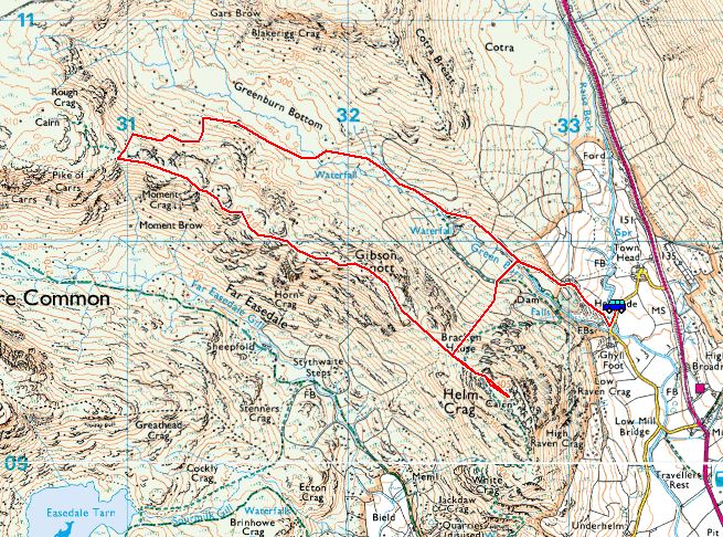
Start Point: Lancrigg Car Park, Easedale (NY 331 083)
Lancrigg Car Park, Easedale – Stythwaite Steps – Tarn Crag East Ridge – Tarn Crag – Codale Head – Sergeant Man – High Raise – Low White Stones – Greenup Edge – Brownrigg Moss – Calf Crag – Gibson Knott – Helm Crag – Lancrigg Car Park, Easedale
Distance: 17.3 km Total Ascent: 805 metres Time Taken: 4 hours 45 minutes Start Time: 07:45
Weather: Cold wind, clear spells, 5°C
I have had this walk lined up for a little while but was waiting for a suitable weather window to do it. I was rewarded for that wait today, the weather being absolutely fantastic and coupled with the surroundings made this walk very enjoyable from start to finish – I can well recommend it. When I looked back through my walks, the last time I was up on Tarn Crag was in 2010 – an unbelievable 14 years ago!


Easedale at the start of the walk and what a beautiful start to the day. The birds were singing and there wasn't a breath of wind.

Looking across Easedale to Sour Milk Gill with Tarn Crag beyond, the pointed summit is where we are heading, climbing along the east ridge.

Heading into Far Easedale towards Stythwaite Steps.

The crossing of Far Easedale Gill at Stythwaite Steps (which is now a footbridge).

Looking into Far Easedale with Calf Crag at the head, the way we will be returning later.

Just at the top of the wall on the climb from the footbridge, these rocks mentioned by Wainwright can be seen. He calls it 'Interesting boulder' and the drawing is shown on The Central Fells, Tarn Crag 6. "The two boulders illustrated above still have foliage (heather and tree) and are a destination popular enough to have encouraged the creation of a path".

Hey, ewe! I wonder what has caught this Herdy's attention?! (Clue: he has 4 legs, a waggy tail and is my walking companion!).

The prominent Rock Tor on the east ridge, a good marker to let you know you are going the right way.

Looks like Fletcher was just in time with his new haircut, he is loving the weather above Easedale Tarn.

Blea Rigg across Easedale Tarn, the conditions were perfect up here.

Tarn Crag ahead with Deer Bield Crag to the right. The summit is the pointed peak in the centre.

Tarn Crag summit. There is not much of a cairn left now.

Water, water everywhere...the pools are frozen still on the tops when we crossed Tarn Crag southwards to have a look over Easedale Tarn.

Back to Tarn Crag summit - this is the rock plinth that marks the summit.

Beautiful shifting light on Codale Tarn, beyond is Harrison Stickle and Pavey Ark.

Fletcher leads the way on the climb to Codale Head.

Sergeant Fletcher checks out Sergeant Man .

The clouds seemed to be building now as we summited Sergeant Man, here looking down on the back of the Langdale Pikes, Pavey Ark to the right with Stickle Tarn visible, Lingmoor Fell and Side Pike central and the Coniston fells beyond.

A magnificent view of Bowfell and the Scafells from Sergeant Man.

Great Gable and High Stile over Glaramara.

Once we reached the summit of High Raise (the centre of the Lake District and the highest point on today's walk) I stopped for a while and had a brew taking in the fantastic views in near perfect conditions. It is one of my favourites fells and it never fails to disappoint. This is looking into Langstrath from the coffee stop.

Look at this view to Skiddaw and Blencathra, it is magnificent. When I first sat down there wasn't a breath of wind and it was silent apart from the chirruping of the Skylarks. 10 minutes later when I stood up to carry on, the wind had picked up noticeably so its looked like I hit the sweet spot with timing there!

I headed down to Low White Stones following the path.

Descending Greenup Edge, even normally dull Ullscarf is looking good today.

It always strikes me that everything seems within easy reach from here, Sergeant's Crag and Eagle Crag especially as they are so near yet for me it is a long drive round to Borrowdale to climb them from that side.

There is a new pavement under construction across Wythburn, I must say these large slabs make the going a lot easier than trying to get across the previously boggy area.

Fletcher crosses the gateway through the invisible fence.

Heading for Calf Crag and the start of the return leg.

looking along Far Easedale to Grasmere from Calf Crag.

Fletcher in a thoughtful pose.

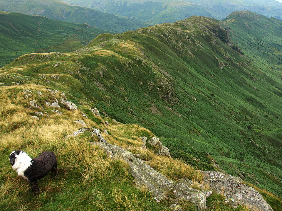
Looking across Far Easedale to Tarn Crag from Gibson Knott.

...and looking along to Helm Crag from the same place.

A Birds Eye view of the path walked earlier. At the bottom is the bridge at Stythwaite Steps. Follow the wall up and round and Wainwright's 'interesting boulder' is also visible.

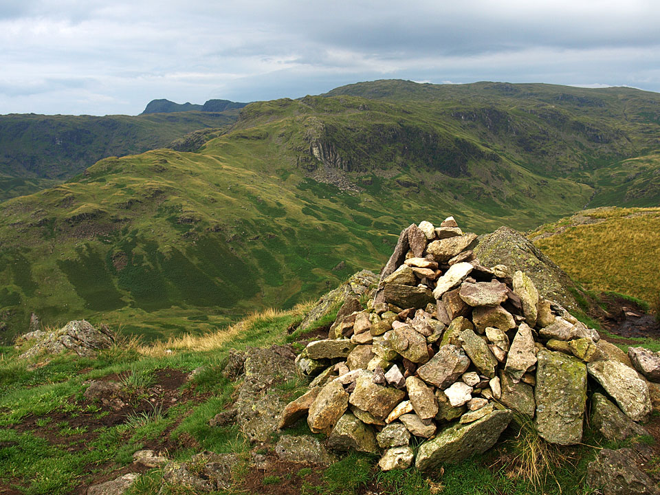
Helm Crag ahead looking across Bracken Hause.


Looking back to Gibson Knott from the climb to Helm Crag.

The Howitzer, the summit rocks that mark the top of Helm Crag - also known as the Lion and the Lamb.


A little further on and these are the rocks that give the fells the local name of The Lion and the Lamb (although from this side it should be The Lamb and the Lion!).


Grasmere - town and lake.

I spotted this plaque hidden away in Lancrigg Gardens on a small rock. It is in Latin, the inscription reads "Hoc in supercilic sedebat Dorothea Wordsworth dum ex ore fratis prope inambulantis carmina describit" translated as "Dorothy Wordsworth used to sit at this spot, writing down the poems that her brother dictated as he walked nearby".