Height: 785 metres / 2575 feet Grid reference: NY 27045 00880 Category: The Southern Fells
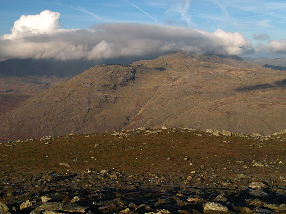
The Scafells, Crinkle Crags and Bowfell are covered by a thick blanket of cloud looking from Great Carrs
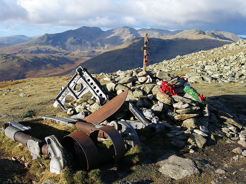
The memorial on Great Carrs
Height: 785 metres / 2575 feet Grid reference: NY 27045 00880 Category: The Southern Fells
The Scafells, Crinkle Crags and Bowfell are covered by a thick blanket of cloud looking from Great Carrs
The memorial on Great Carrs
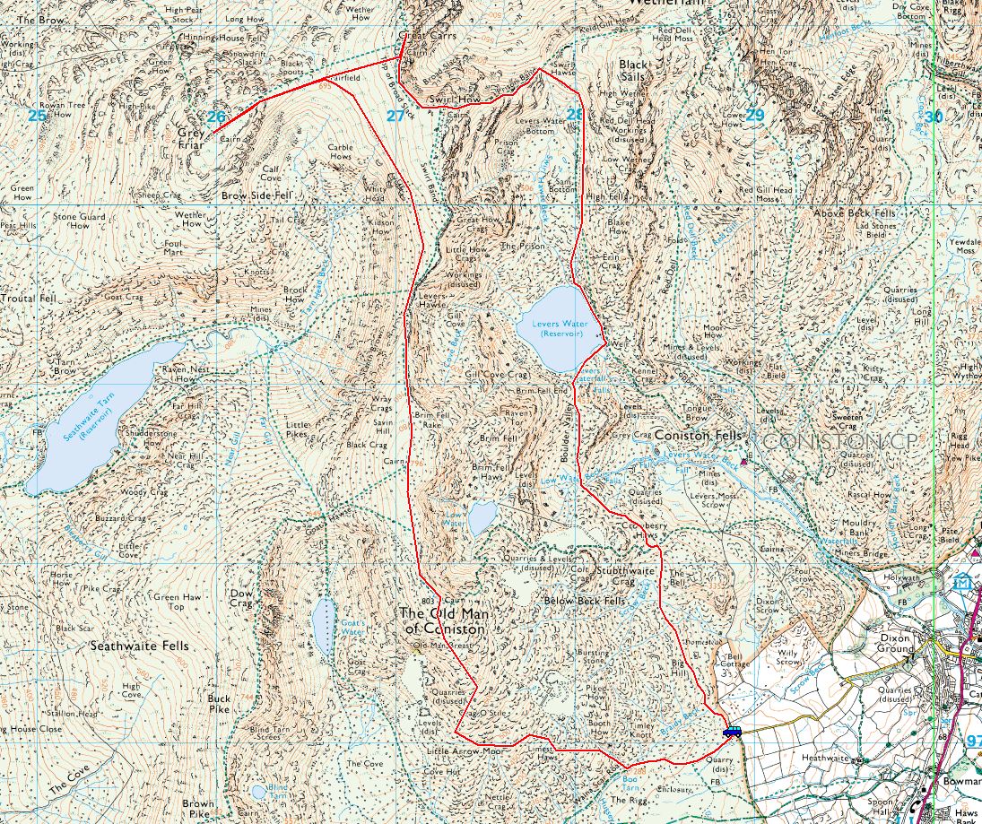
Start Point: Walna Scar road (SD 289 970)
Walna Scar road – Coniston Old Man – Brim Fell – Levers Hawse – Grey Friar – Great Carrs – Swirl How – Prison Band – Swirl Hawse – Levers Water – Boulder Valley – Walna Scar road
Distance: 8.5 miles Total Ascent: 968 metres Time Taken: 4 hours 30 minutes Start Time: 07:15
Weather: Breezy, cold on top, 12°C
Today’s walk involved an early start to take in a round of the Coniston fells. It was a solitary walk today and there was no-one around and that wind was oh-so cold, I think I have forgotten what it can be like given all the recent warm weather we have had – brrr! This walk will feature in an issue of Trail Magazine soon.

Firstly, a few sunset shots from last night, 12th October...Black Combe.

West Coast sunset.

A beautiful evening. On with the walk...

Sunrise contrails

Moon over Walna Scar

Black Combe, Brown Pike and Blind Tarn

Looking across Low Water to Wetherlam from The Old Man

Sky above the summit cairn

There was lots of cloud flitting across the tops today, here it can be seen blowing across Swirl How to the right

Looking back to The Old Man

You won't get lost on this path with a proliferation of cairns

Looking back from Brim Fell

Brim Fell

Great How Crags and Swirl How - I traversed across about halfway up the climb to head for Grey Friar

Brim Fell and Dow Crag from the traverse

I like the way the cairn mirrors the fells on Grey Friar

Bit windy Dougal?

The Matterhorn Rock

The WW2 memorial

Grey Friar from Great Carrs

Swirl How, The Old Man, Brim Fell and Dow Crag all in a row

Atmospheric happenings over the Scafells and Bowfell

The descent of Prison Band, Wetherlam ahead

Crossing Levers Water

Into Boulder Valley

Modern day industry continues at Coniston
Start Point: Walna Scar road (SD 289 970)
Walna Scar road – Coniston Old Man – Brim Fell – Levers Hawse – Great How – Great Carrs – Swirl How – Prison Band – Swirl Hawse – Levers Water – Boulder Valley – Walna Scar road
Distance: 7 miles Total Ascent: 862 metres Time Taken: 4 hours Start Time: 07:30
Weather: Some sunny spells, cool on top with showers, 16°C
The Coniston fells were shrouded in mist when I set off and they were in and out of the clouds all morning as the sun tried its best to shine through. It is a great ridge walk from The Old Man to Swirl How and a fair while since I have done it – I’m glad I did today as I enjoyed it and saw no one this Monday morning.

Looking a bit grey at the start of the walk.

...as so often happens, away from the fells it is blue sky here looking over Boo Tarn.

The Cove.

Coniston Water.

Boiling clouds to the east, on the Ill Bell ridge.

Brown Pike and Blind Tarn catch the sun.

Low Water from The Old Man.

he summit of The Old Man - no one here but me and Dougal (and of course we paid a visit to Angus and Casper).

Brim Fell.

Great Carrs, Swirl How and Great How Crags across Levers Hawse.

Seathwaite Tarn, Harter Fell to the right.

Brim Fell and Dow Crag from Little How Crags.

Levers Water and Coniston Water beyond.

The ridge just walked from The Old Man to Brim Fell, Dow Crag to the right.

Pensive Dougal.

Swirl How from Great Carrs.

Nearly all in one shot - the Coniston fells from Great Carrs.

The Royal Canadian Air Force memorial on Great Carrs, Grey Friar beyond.

Swirl How.

Dougal looking for the Scafells - they are over to the left and have been lost all day.

Descending Prison Band, Wetherlam ahead.

Down at Levers Water.

Brim Fell end from a dry looking Levers Water. About 30 seconds after this photo the heavens opened to make a very damp end to the walk through Boulder Valley.
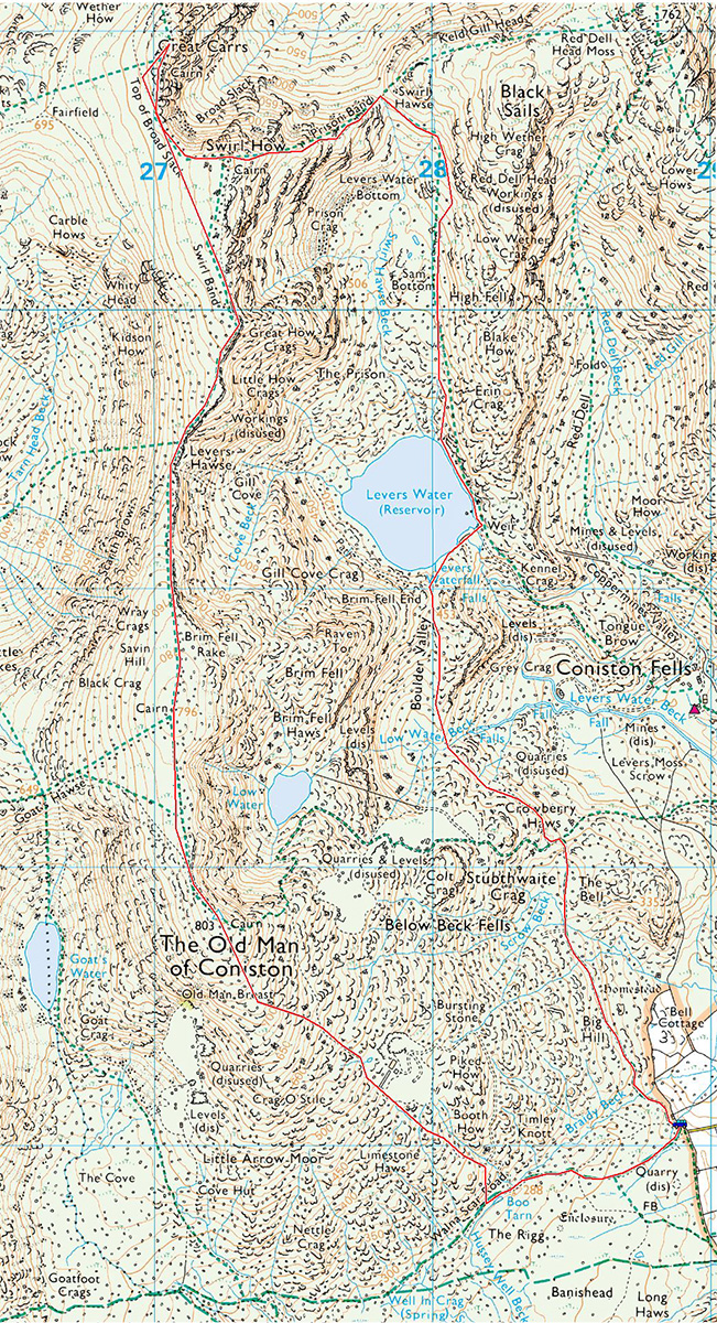
Start point: Fell Foot, Little Langdale (NY 296 032)
Fell Foot – Rough Crags – High End – Wet Side Edge – Hell Gill Pike – Little Carrs – Great Carrs – Top of Broad Slack – Swirl How – Prison Band – Swirl Hawse – Wetherlam – Birk Fell Hawse – Greenburn – Fell Foot
Distance: 5.9 miles Total Ascent: 883 metres Time Taken: 3 hours 45 minutes
Weather: Changeable, cool. 13C.
Today I had a walk around Greenburn from Little Langdale, the weather didn’t seem to hold much promise when I set off but it was fascinating to watch the rapidly changing conditions as I walked, with it seemingly changing by the minute. It was very wintry and cold on the top of Great Carrs, I even had to put my winter jacket on – good job Casper was wearing his!

Greenburn route map.

Early morning, Coniston Water.

Brown Howe, Coniston Water.

Autumn reflections.

The mist rising from the lake.

Who knew what the weather would throw up today? It was cold and hazy when I set off from Fell Foot, here with Rough Crags ahead and Wetherlam beyond Wet Side Edge.

Rough Crags from one of the many shepherd's cairns along the path.

A magnificent Rowan tree on the banks of the River Brathay.

Wetherlam from the ridge.

The head of Greenburn with cloud on the top of Great Carrs.

To the east was a layer of cloud covering Little Langdale and beyond.

Little Langdale from High End, Little Langdale Tarn in view.

Pike o' Blisco from High End.

Looking across Greenburn, there is a bit of mist around there too as the sun tries to burn through.

Wet Side Edge.

The view across Wrynose Pass to Cold Pike, Crinkle Crags, Bowfell and Pike o' Blisco with mist forming below.

The inversion to the east was slowly but surely creeping towards me. Ooh, I was getting all excited now!

The view from the top of Wet Side Edge.

A glimpse of the Scafells beyond Wrynose Fell from Hell Gill Pike. From here it was up into the mist, pretty cold it was too.

The memorial to the Canadian Air Crew on Great Cars.

Heading for Swirl How.

Casper in eerie light on the summit of Swirl How. It was freezing up here, time to put the gloves on.

Descending Prison Band towards Wetherlam as the mist clears.

Levers Water.

Prison Band.

Looking back to Prison Band across Swirl Hawse.

The path to Wetherlam - all sunshine and blue sky now.

Cold Pike, Pike o' Blisco and the Crinkles have disappeared under cloud now from the summit of Wetherlam.

The inversion to the east.

The cloud beginning to break over Little Langdale.

Descending Wetherlam Edge, a rougher path than you might think.

I took the path down into Greenburn from Birk Fell Hawse and almost in the blink of an eye the valley filled with cloud. With the sun shining from directly behind there was a Brocken Spectre constantly there for a while, seen here looking across to the Langdale Pikes. What a fantastically graded path this old miners track was too, a real joy to walk.

Brocken Spectre.

Pike o' Blisco from the very edge of the inversion.

Can't get enough of this one!

Almost as quickly as it settled in the valley, the mist rapidly began to rise as it warmed. This photo was as I was descending and the mist was racing up to meet me.

Descending to the ruins of Greenburn Copper Works.

Greenburn Copper Works. It is hard to imagine what this tranquil place would have been like during the heyday of these works, but I bet it was a bit different to now!

There were some magnificent cascades and pools on Greenburn Beck, I must remember this place for next summer as a likely swimming spot.

Rowan Tree alongside Greenburn Beck, now in bright sunshine.

Casper walks the plank to get across Greenburn Beck.
Start point: Walna Scar road (SD 289 970)
Walna Scar road – Coniston Old Man – Brim Fell – Levers Hawse – Grey Friar – Great Carrs – Swirl How – Prison Band – Swirl Hawse – Levers Water – Boulder Valley – Walna Scar road
Distance: 8.2 miles Total Ascent: 925 metres Time Taken: 4 hours
Weather: Icy at first, sunny later. 0oC at first, 7oC max.
I didn’t know what the weather would do today; it looked clear enough but the forecasts predicted otherwise so I opted for a circuit of the Coniston fells which seemed to be enjoying a decent amount of sunshine. Coniston Water was covered with a blanket of cloud as happens on this type of freezing morning but higher up it was a mix of wispy clouds and clear blue skies. The highlight was the fabulous stillness and reflections on Levers Water.


The Old Man of Coniston from the Walna Scar Road bathed in early morning sunlight. The high fells had a cap of cloud on them today.

Traversing Little Arrow Moor.

Coniston Water was covered in a thick carpet of cloud...

...with the higher ground either side looking like islands in the sea. Beacon Fell is prominent on the right.

Buck Pike and Dow Crag.

Brown Pike.

Climbing to The Old Man and into the mist.

An eerie light on the summit of a deserted Old Man.

Back out of the mist briefly in the dip between the Old Man and Brim Fell.

Casper on Brim Fell - looks a bit cold lad!

Descending to Levers Hawse. The north facing slopes haven't caught any sun yet so remain frosted.

Seathwaite Tarn and Harter Fell - yesterday I got a view looking the other way.

Great How Crags. We didn't climb here but took the faint path to the left, contouring the lower slopes heading for Grey Friar.

Looking back to The Old Man and Brim Fell, it looks like there has been an explosion up there!

It looks decidedly dull on the top of Grey Friar.

Cold Pike and Pike o' Blisco from Matterhorn Rock on Grey Friar.

The summit of Grey Friar, Harter Fell beyond.

Looking back to Grey Friar, which is now clear, from Fairfield - the col between Grey Friar and Great Carrs.

Grey Friar and Harter Fell from the memorial for the Canadian Air Force crew that crashed their Halifax Bomber here during World War 2. The Scafells, Crinkle Crag and Bowfell are covered by a thick blanket of cloud looking from Great Carrs. Casper on Swirl How. Descending Prison Band towards Wetherlam. Crinkle Crags and Bowfell are clearing now. Red Tarn and Pike o' Blisco from Prison Band. Levers Water and Great How Crags. Levers Water reflections. The Coniston fells and Coppermines Valley. Return to top Previous Walk 14th November 2007 Harter Fell Next Walk 22nd November 2007 Three Haweswater walks Grey Friar and Harter Fell from the memorial for the Canadian Air Force crew that crashed their Halifax Bomber here during World War 2. The Scafells, Crinkle Crag and Bowfell are covered by a thick blanket of cloud looking from Great Carrs. Casper on Swirl How. Descending Prison Band towards Wetherlam. Crinkle Crags and Bowfell are clearing now. Red Tarn and Pike o' Blisco from Prison Band. Levers Water and Great How Crags. Levers Water reflections. The Coniston fells and Coppermines Valley. Return to top Previous Walk 14th November 2007 Harter Fell Next Walk 22nd November 2007 Three Haweswater walks Grey Friar and Harter Fell from the memorial for the Canadian Air Force crew that crashed their Halifax Bomber here during World War 2.

The Scafells, Crinkle Crag and Bowfell are covered by a thick blanket of cloud looking from Great Carrs.

Casper on Swirl How.

Descending Prison Band towards Wetherlam.

Crinkle Crags and Bowfell are clearing now.

Red Tarn and Pike o' Blisco from Prison Band.

Levers Water and Great How Crags.

Levers Water reflections.


The Coniston fells and Coppermines Valley.
Start point: Walna Scar road (SD 289 970)
Walna Scar road – Brown Pike – Buck Pike – Dow Crag – Goat’s Hawse – Coniston Old Man – Brim Fell– Levers Hawse – Great How – Grey Friar – Great Carrs – Swirl How – Prison Band – Swirl Hawse –Wetherlam – Red Dell – Boulder Valley – Walna Scar Road
Distance: 11.8 miles Total Ascent: 1320 metres Time Taken: 5 hours
Weather: Cold and windy. 4oC.
That wasn’t supposed to happen! The weather was predicted to be the same as yesterday, blue skies and general loveliness above the clouds – however, rule #1 is there is no accounting for the weather. There was a strong wind and grey skies above the low lying fog with the upper clouds only clearing at the very end of the walk. This was a good long walk on the shortest day of the year and the fells were surprisingly busy today.


Walking along the Walna Scar road, we were quickly above the low lying cloud, here looking to Torver High Common.

At Cove Bridge, it was fairly obvious that this wasn't going to be a still blue sky temperature inversion day. Brown Pike is in the cloud beyond the bridge.

Coniston Old Man, the cloud sticking to the summit.

Once onto the Brown Pike - Buck Pike ridge the icy wind was really blowing up a gale. A fleeting gap in the clouds reveals Harter Fell.

Casper sticking his tongue out to the wind.

Looking back from Dow Crag to Buck Pike.

Descending from Dow Crag, the cloud clinging to Brim Fell.

Clear on The Old Man - for now, anyway!

The mist still hanging in the valleys to the south.

Grey Friar, Great Carrs, Swirl How and Brim Fell - all to be visited today.

Looking south over Goats Water in the lee of Dow Crag.

Looking south, Beacon Fell centre.

Approaching the summit of The Old Man.

The Old Man of Coniston.

The easterly view to the Furness Fells over Low Water shortly before being engulfed in cloud again. It was a cold, strong wind that blew walking along to Brim Fell and beyond.

Levers Water from Little How Crags after walking through the worst of the storm - but it was back into the mist for the climb to Grey Friar then Great Carrs and Swirl How.

Descending Prison Band to Black Sails and Wetherlam from Swirl How.

On the way to Wetherlam, the clouds parted and blue sky and sunshine appeared to the east. Behind, Coniston remained under brooding skies.

Pike o' Stickle from Wetherlam.

Looking north-east over Little Langdale.

The Langdales under a thick blanket of cloud, Blea Tarn centre.

The mist still clinging to the valleys.

Angus.

Casper.

The sky is ever clearing.

Looking back along the furrowed path to Wetherlam.

The southern end of Windermere still under a blanket of cloud.

Red Dell.

Crossing Levers Water Beck.

The Pudding Stone, Boulder Valley.

Looking over Coppermines Valley to Black Sails and Wetherlam.
Start point: Walna Scar road (SD 289 970)
Walna Scar road – Brown Pike – Buck Pike on Seathwaite Fell – Dow Crag – Goat’s Hawse –Coniston Old Man – Brim Fell – Levers Hawse – Great How – Swirl Band – Top of Broad Slack –Great Carrs – Swirl How – Prison Band – Swirl Hawse – Levers Water – Boulder Valley – Walna Scar road
Distance: 10.5 miles Total Ascent: 2670 metres Time Taken: 4 hours 30 minutes
Weather: Very cold with gale force winds. 3oC, but much colder with the wind chill.
It didn’t look too promising when I set off along the Walna Scar Road and sure enough when I reached Brown Pike the wind was gale force and the hailstones were shotblasting my face. Magically, when I reached Dow Crag, the clouds cleared (blown away presumably!) and there were lovely blue skies. The wind was ever present and made the walking difficult at times; full winter gear was required today. Today was the first time I have ever been recognised on the fells from this website (okay, Angus was recognised to be technically correct). He’s famous that dog!


So that's what that little shelter on the Walna Scar road is for!

Gale force wind and hailstones (they hurt!) on Brown Pike, Buck Pike ahead. I thought Angus was a goner walking across here, it was that bad.

Looking back to Brown Pike and Blind Tarn from Buck Pike.

The path to Dow Crag.

Now it's blue skies - the Coniston fells from Dow Crag.

The view from The Old Man of Coniston - Low Water below and a glimpse of Levers Water with the Black Sails ridge and Wetherlam beyond.

The route from The Old Man with Brim Fell in the centre and Swirl How and Great Carrs visible to the right. The Scafell massif is in the left distance.

Angus on the summit of The Old Man - phew, made it!

...but it's still a bit windy!

Levers Water from Great How Crags, Coniston Water in the distance.

Great Carrs from Top of Broad Slack.

Grey Friar.

Wetherlam.

The view from Great Carrs, annotated version below.


The memorial on Great Carrs, complete with plane wreckage.

Swirl Hawse across Levers Water.

The Coppermines Valley and Coniston from Boulder Valley.
Start point: Three Shire Stone (NY 277 027)
Three Shire Stone – Wet Side Edge – Little Carrs – Great Carrs – Hell Gill Pike – Wet Side Edge – Three Shire Stone
Distance: 4 miles Total Ascent: 400 metres Time Taken: 1 hour 30 minutes
Weather: Wet and windy. 10oC.
Today is Armistice Day and alongside the two minute silence at 11am, there was special service taking place on Great Carrs to commemorate the crewmen (seven Canadian and one Briton) who died in a World War II plane crash there. The Armistice Day service was held to rededicate a memorial to the crew members of the fateful Halifax bomber which crashed after becoming lost in bad weather in October 1944. Officiated by the Vicar of Coniston, the Rev Mark East, the ceremony was attended by representatives of the RAF and the Canadian Embassy.
The weather was absolutely atrocious up there with the wind being gale force on the top, so no lovely views today!


A bit busy around the Three Shire Stone today.

Looking along Wrynose Pas and Wrynose Bottom along the River Duddon from the steep climb to Wet Side Edge.

The memorial service on Great Carrs...

...The Last Post...

...and the new memorial.

Just how windy is it up here Angus?

A drink in a tarn on Hell Gill Pike.
Start point: Coniston (SD 150 896)
Coniston – Levers Water – Swirl Hawse – Prison Band – Swirl How – Great Carrs – Swirl Band – Great How – Levers Hawse – Brim Fell – Coniston Old Man – The Bell – Coniston
Weather: Dull, damp with a cold wind.
Today’s walk was a round of the Coniston fells. The weather has taken a turn for the worse again and the clear views and picture postcard snowy scenes have all blown away – the wind was gale force at times and the rain relentless.


Church Beck and Miners Bridge.

Looking up the miners road to the Youth Hostel.

Mine workings and Levers Water Beck.

The dam on Levers Water.

The remains of the snow on Great Carrs.

A picture tells a thousand words...James on Great Carrs.

The Bell from the descent of The Old Man.

Walna Scar road from The Bell.

Church Beck from Miners Bridge.


Start point: Coniston (SD 304 976)
Coniston – Walna Scar road – Brown Pike (48) – Buck Pike on Seathwaite Fell (49) – Dow Crag (50) – Goat’s Hawse – Coniston Old Man (51) – Brim Fell (52) – Levers Hawse – Great How (53) – Grey Friar (54) – Little Carrs (55) – Hell Gill Pike (56) – Great Carrs (57) – Swirl How (58) – Prison Band – Swirl Hawse – Black Sails (59) – Wetherlam (60) – Coniston
Weather: Overcast with sunny spells. Very windy.
A long Coniston round today taking in all the highest tops and some of the less well known ones. It was a drizzly start but this soon cleared and there were lots of sunny intervals with some cloud coming in. There was a strong breeze all day growing to gale force by the end of the walk.
You may have noticed a distinct lack of Tarns on this walk. This is because there were so many to be seen, I have given them their own page and they can be viewed here.


The initial ascent was via the Walna Scar road which is a good hours trek from Coniston before the highest point is reached. The picture is of Cove Bridge across Torver Beck

and a shelter on the roadside 'just big enough for one person or a honeymoon couple' - AW.

A sharp ascent from the Walna Scar road to the summit of Brown Pike. The furthest fell is Black Combe with Caw visible behind Walna Scar.

An easy traverse to Buck Pike. Dow Crag is the next fell along the path, in the distance Great Carrs, Swirl How and Great How Crags coming round to Brim Fell on the right.

Another short walk to Dow Crag summit. Looking down easy gully to the pinnacle.

Looking through Swirl Hawse to Dunmail Raise in the distance.

From Dow Crag, it's a descent to Goat's Hawse and then a steep ascent back up to the Old Man of Coniston.


Dow Crag from the Old Man.

An easy, grassy ramble to Brim Fell

and then another descent/ascent of Levers Hawse to the summit of Great How

Off the beaten track now to a fairly long trek contouring round to Grey Friar, Looking out towards Eskdale and the Scafell range and then another contour round to Hell Gill Pike and Little Carrs.

Little Carrs summit looking towards Little Langdale Tarn.

The summit of Hell Gill Pike. Harter Fell is on the left and Hard Knott on the right. The Hardknott - Wrynose road can be seen on the bottom right of the picture.

An easy ascent again to Great Carrs summit...

and the memorial to the World War 2 Canadian Air Force bomber that crashed there.

Into the mist and gale force wind now up to the summit of Swirl How

Then a steep descent of Prison Band before ascending Black Sails. The picture is from Black Sails summit showing Coniston Water and Levers Water.

The sun shines over Langdale from Black Sails. Right of centre, Pavey Ark can be seen overlooking Stickle Tarn with the distinctive shape of Pike O' Stickle to the left.

Another easy traverse to Wetherlam. Pike o' Blisco and The Langdale fells are seen here from Wetherlam summit.

Mine workings on The old Man seen from the sharp descent of Wetherlam

Miners Bridge on the way back to Coniston.
Start point: Coniston (SD 304 976)
Coniston – Walna Scar road – Brown Pike (48) – Buck Pike on Seathwaite Fell (49) – Dow Crag (50) – Goat’s Hawse – Coniston Old Man (51) – Brim Fell (52) – Levers Hawse – Great How (53) – Grey Friar (54) – Little Carrs (55) – Hell Gill Pike (56) – Great Carrs (57) – Swirl How (58) – Prison Band – Swirl Hawse – Black Sails (59) – Wetherlam (60) – Coniston
It was amazing how many tarns and stretches of water could be seen on this Coniston Round; they are shown on this page.

Boo Tarn, just off the Walna Scar road. This was nothing more than reeds and marsh.

Blind Tarn seen from Buck Pike. It is named blind because there is no outlet.

Goat's Water from Goat's Hause. Coniston Water and Morecambe Bay can also be seen.

Low Water from The Old Man of Coniston with a glimpse of Levers Water to the north east.

Levers Water and Coniston Water from Great How Crags.

Red Tarn between Cold Pike and Pike O' Blisco from Grey Friar summit.

Seathwaite Tarn from below Swirl Band.

Esthwaite Water and Windermere from Wetherlam.

Greenburn Reservoir and Little Langdale Tarn from Little Carrs.