Height: 388 metres / 1273 feet Grid reference: NY 43303 19817 Category: The Far Eastern Fells
Hallin Fell summit
Height: 388 metres / 1273 feet Grid reference: NY 43303 19817 Category: The Far Eastern Fells
Hallin Fell summit
Start point: St. Peter’s Church, Martindale (NY 436 191)
St. Peter’s Church, Martindale – Hallin Fell – Martindale Hause – Steel Knotts (Pikeawassa) – Brownthwaite Crag – Wether Hill – Loadpot Hill – Arthur’s Pike – Bonscale Pike – St. Peter’s Church, Martindale
Distance: 8.7 miles Total Ascent: 860 metres Time Taken: 3 hours 40 minutes Start Time: 07:00
Weather: Some bright spells but cool. 11ºC
It started off fairly bright this morning but that soon changed once I was up onto Steel Knotts. Looking up to the High Street ridge, the clouds came down on it and I thought I was in for a day in the clag – fortunately it lifted before I got there but the breeze made it surprisingly cold today.

Fusedale route map.

A little bit of early morning sunshine on the climb to Hallin Fell.

The Nab and Beda Fell again from higher up the climb.

Ullswater from Hallin Fell.

Steel Knotts ahead, St Peter's Church can be seen in the trees in the centre.

Looking the other way across St Peter's Church to Hallin Fell beyond.

Lanty Tarn.

The weather gradually closed in on the climb of Steel Knotts. Dougal and Casper are hiding on the rock tor that is the summit of Steel Knotts, Pikeawassa.

Dougal does that sheepdog thang when they spot a sheep.

Beda Fell.

Looking back to Steel Knotts from Brownthwaite Crag.

The ruin at the head of Fusedale before the climb to the High Street ridge and Wether Hill. It was so cold now I had to put a jacket on along with hat and gloves, not great for May.

The summit of Wether Hill, at least the cloud has cleared now.

The grassy expanse leading to Loadpot Hill, on the left is a herd of wild fell ponies.

Loadpot Hill.

First we are heading for Arthur's Pike, which is on the right before cutting back to Bonscale Pike on the left in this photo.

Dougal's ear gives away the stiff breeze up here today.

Arthur's Pike.

Dougal checks out the twin towers on Bonscale Pike.

Ullswater from Bonscale Tower.

Bonscale Pike.

Hallin Fell and beyond.

Fusedale and Steel Knotts from the steep descent.

Crossing Fusedale Beck.
Start point: St. Peter’s Church, Martindale (NY 436 191)
St. Peter’s Church, Martindale – Hallin Fell – Martindale Hause – Steel Knotts (Pikeawassa) – Brownthwaite Crag – Wether Hill – Loadpot Hill – Arthur’s Pike – Bonscale Pike – St. Peter’s Church, Martindale
Distance: 8.7 miles Total Ascent: 860 metres Time Taken: 3 hours 45 minutes
Weather: Overcast with some drizzle. 19ºC.
It has been a long time since I was over this way – in fact it seems like a long time since I have been over any way! However, needs must and I was glad to get out today even though I would have preferred the sunshine of yesterday. Normally I find this sort of terrain easy going and I thought I managed to do the walk surprisingly quickly as I felt a little unfit and was puffing and panting a bit on the climb up to Wether Hill. I must get out more to keep my fitness levels up…


The Nab and Beda Fell from the climb to Hallin Fell.

Steel Knotts over Martindale Church.

It's all looking a bit murky in Boredale.

Ullswater from Hallin Fell.

Martindale and Boredale with Beda Fell in the centre.

Beda Fell across the reedy Lanty Tarn.

Hallin Fell from the climb to Steel Knotts.

Ullswater from Steel Knotts.

The view of Ullswater from Pikeawassa, the summit of Steel Knotts.

Pikeawassa.

The way ahead to Brownthwaite Crag.

Steel Knotts and Fusedale from Brownthwaite Crag.

Brownthwaite Crag and Steel Knotts from the ruins below Wether Hill. From here it was a steep climb up into the murk and mist in the drizzle on Wether Hill.

Heading for Loadpot Hill from Wether Hill.

The summit of Loadpot Hill.

Pooley Bridge and Dunmallard Hill from Arthur's Pike.

Ullswater from Arthur's Pike.

Casper, the mucky pup!

Crossing Swarth Beck.

Ullswater from Bonscale Pike.

The view from the two prominent cairns.

The cloud seems to be clearing now.

Steel Knotts from the steep descent from Bonscale Pike.

Hallin Fell over Howtown.

Place Fell gets some sunshine. The path used to climb back to the church is clear to see through the bracken on the left.

The view into Fusedale.
Start point: Howtown pier (NY 443 199)
Howtown – Hallin Fell – St. Peter’s Church – Howtown
Distance: 2.7 miles Total Ascent: 260 metres Time Taken: 3 hours
Weather: Sunny with a cool breeze, clouding later. 14oC.
It’s half-term this week (again? already?!), so I took Connie, her friend Maya and the dogs (of course!) for a trip on the Ullswater Steamers for a short walk up to Hallin Fell. We just hit it right with the weather, with the rain coming in by the time we got back to Glenridding at the end. If you ever see someone loaded down with a rucksack + 2 more pink rucksacks + camera + two excitable dogs + two children…that will be me! They won’t do their own carrying these young girls you know…


Leaving the pier at Glenridding, looking back to the sister steamer Raven.

Flag's aloft!

Lots of excitement on the steamer on the way to Howtown.

Looking back to Arnison Crag along Ullswater.

Hallin Fell as we pull into Howtown.

Steel Knotts above Howtown.

Beda Fell and Martindale.

Ullswater from the north cairn on Hallin Fell.

The flat top of Hallin Fell ahead.

Arthur's Pike and Bonscale Pike.

Ullswater.

Conquering the south face of Hallin Fell.

Casper loves the sunshine here on the summit of Hallin Fell.

So do Connie and Maya - made it at last!

Casper.

Ullswater from our picnic place. Conditions were just about perfect now - what a view.

Looking south-west over Ullswater.

The Helvellyn range, the pointed Catstycam is in the centre.

Close-up on Helvellyn. Striding Edge is to the left with Swirral Edge leading down to Catstycam on the right.

Ullswater with Dunmallard Hill at the northern end.

Casper and Angus on Hallin Fell.

The summit of Hallin Fell.

Beda Fell, Boredale and Place Fell from the descent of Hallin Fell.

Martindale.

The way down.

The Nab and Beda Fell.

Not so fast!

It's much easier going down than up.

St Peter's Church, Martindale with Hallin Fell Behind.

Heading back to the ferry...

...down to Howtown.

Hallin Fell from Howtown.

Just made it. The blue sky has gone now and rain is on the way, here looking back to Hallin Fell from the steamer.
Start point: St. Peter’s Church, Martindale (NY 436 191)
St. Peter’s Church, Martindale – Hallin Fell (378) – Martindale Hause – Steel Knotts (Pikeawassa) (379) – Brownthwaite Crag (380) – Gowk Hill (381) – Wether Hill (382) – Loadpot Hill (383) – Arthur’s Pike (384) – Bonscale Pike (385) – Swarth Fell (386) – St. Peter’s Church, Martindale
Distance: 9.1 miles Total Ascent: 1002 metres Time Taken: 3 hours 45 minutes
Weather: Overcast, hazy and warm, 20°C.
Today’s walk was a round of remote Fusedale on the eastern side of Ullswater. It was a steep pull onto the High Street ridge from Steel Knotts, but once on the top, the going is easy and I followed the old Roman Road for part of the route. Although it was warm today, it remained overcast virtually throughout with the odd sunny moment and a heavy shower towards the end.

Fusedale Circuit route map.

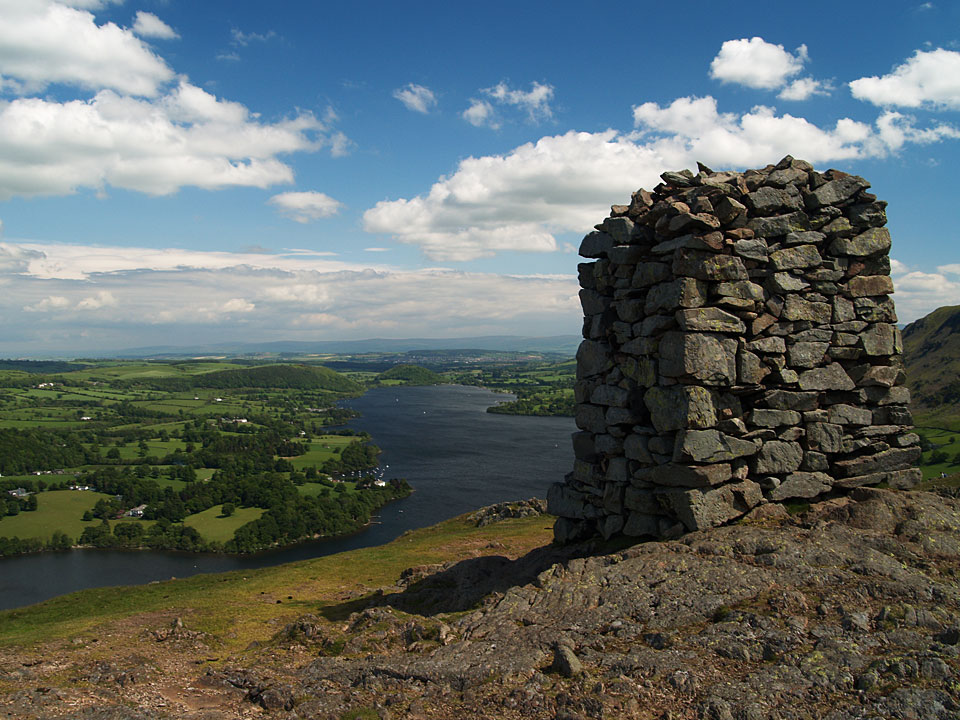
The large obelisk on Hallin Fell, looking along Ullswater.

Beda Fell and Martindale from Hallin Fell.

St Peter's Church, Martindale with Hallin Fell Behind.

Looking back to Steel Knotts from Brownthwaite Crag, Fusedale is to the right.

Ramps Gill Head, Rest Dodd and The Nab from Gowk Hill.

Following the Roman road on Wether Hill.

A launch on Ullswater from Bonscale Pike.

The head of Ullswater from Bonscale Pike.

Hallin Fell, the first fell of the round, from Swarth Fell.

Steel Knotts and Fusedale.
St. Peter’s Church, Martindale – Hallin Fell (148) – Martindale Hause – Steel Knotts (Pikewassa) (149) – Brownthwaite Crag – Wether Hill (150) – Loadpot Hill (151) – Arthur’s Pike (152) – Bonscale Pike (154) – St. Peter’s Church, Martindale

Hallin Fell summit cairn.

Shrouded in mist, L-R: Steel Knotts, The Nab, Beda Fell.

Hallin Fell stands behind St.Peter's church, Martindale.

Beda Fell from the top of Steel Knotts.

The Nab from Steel Knotts summit.

Steel Knotts rock tor Pikeawassa, 'the sharpest in Lakeland'.

Looking back on Steel Knotts from the steep ascent of Wether Hill.

Wether Hill summit cairn. Raise can just be seen in the far distance.

All that remains of the ruins of Lowther House on the way to Loadpot Hill summit.

View from Wether Hill summit.

Loadpot Hill summit cairn.

Arthur's Pike summit cairn with Ullswater below.

The two towers on the side of Bonscale Pike. AW - 'The lower one is the work of a craftsman, the upper one the effort of amateurs'.

Bonscale Pike summit cairn looking along Ullswater to Dunmallard Hill.

The sun sets over Hallin Fell from Sharrow Bay.