Height: 822 metres / 2697 feet Grid reference: NY 36907 11208 Category: The Eastern Fells
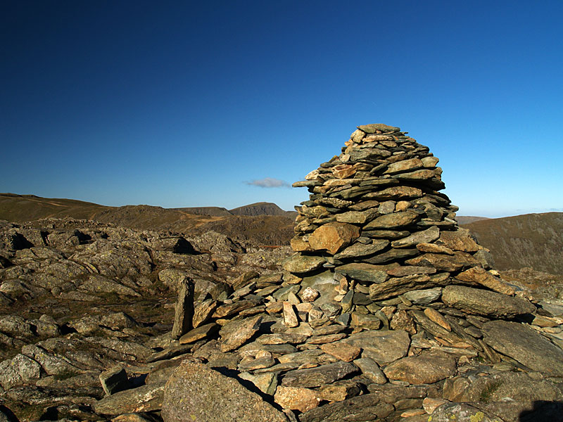
The summit of Hart Crag
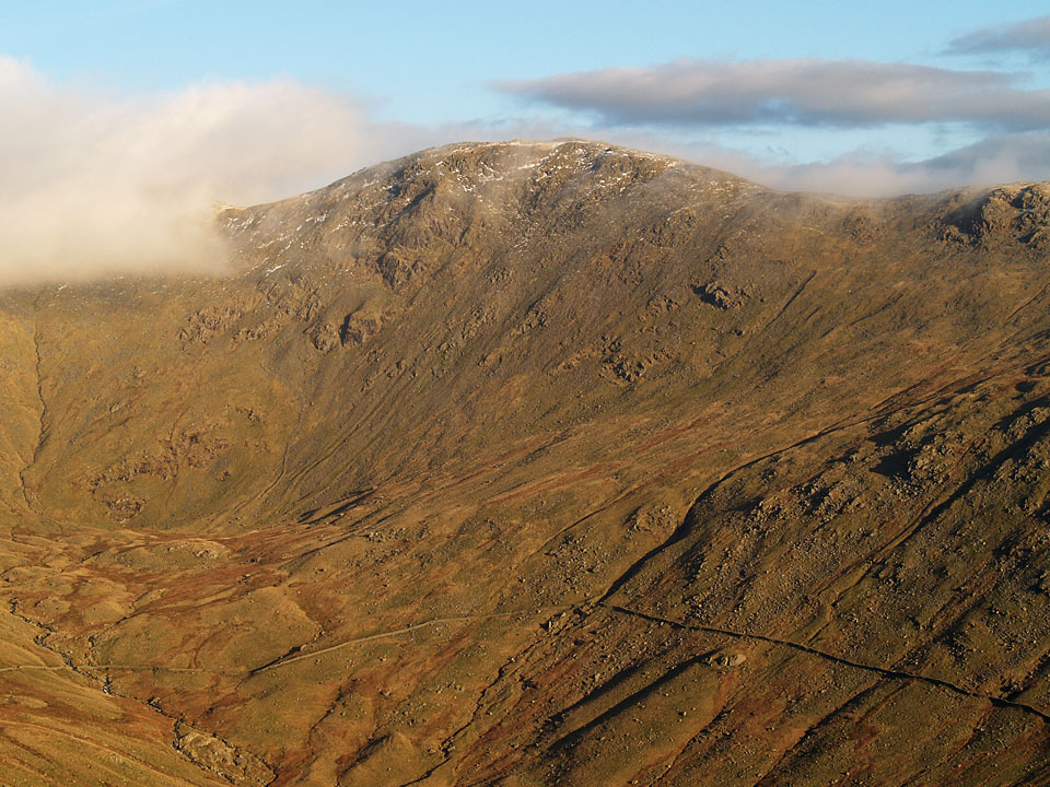
Hart Crag across Rydal Valley
Height: 822 metres / 2697 feet Grid reference: NY 36907 11208 Category: The Eastern Fells
The summit of Hart Crag
Hart Crag across Rydal Valley
Start Point: Rydal (NY 365 062)
Rydal – Nab Scar – Heron Pike – Rydal Fell – Great Rigg – Fairfield – Hart Crag – Dove Crag – High Pike (Scandale) – Low Pike – Low Sweden Bridge – Rydal Park – Rydal
Distance: 10 miles Total Ascent: 1180 metres Time Taken: 5 hours Start Time: 07:35
Weather: Beautiful, warming up nicely to 17°C
The weather experts weren’t wrong today, it was an absolutely gorgeous morning for a walk around the Fairfield Horseshoe – one I haven’t done (unbelievably) since 2007. There wasn’t anyone around either until two thirds of the way when we met one or two people. I think this is the last day of the long hot summer as the weather is set to turn over the next few days…


Early morning mist on Windermere, from Waterhead

View along the jetty

What a beautiful sunrise

Inversion over Ambleside and Windermere from the climb to Nab Scar

Climbing to the sun, it is a gorgeous morning

This view was behind me so frequent stops were required to check it out

Misty trees

A great view across Rydal and Grasmere to the Coniston fells and across to Bowfell

The sun is starting to burn away the early mist

Heron Pike from Nab Scar

Looking back to the Coniston fells, Coniston Water is distant left

Clear as clear can be on Heron Pike - Dougal seems to be enjoying himself as well

Heading for Rydal Fell, Great Rigg and Fairfield ahead

Looking to Rydal Head - Great Rigg, Fairfield and Hart Crag in view

Hart Crag reflected

Lapping up the good weather

Great Rigg

Grasmere and the Coniston fells

Fairfield from Great Rigg

Heading for Fairfield but with a peek across Grisedale Tarn to Helvellyn

Cofa Pike and St. Sunday Crag from Fairfield

A great view of Dollywaggon Pike, Nethermost Pike and Helvellyn from Fairfield

Dougal in pensive pose

Windermere and two sentinels of Rydal Head. I'll give you two guesses where Dougal is!

On Hart Crag

Looking the other way towards Patterdale

High Pike from Low Pike

Crinkle Crags and Bowfell across Rydal Water

The outward leg of the Fairfield Horseshoe from Rydal Park

On the way back we met up with Louise and Fletcher at Fell Foot. He is growing by the day!
Start point: Rydal (NY 365 062)
Rydal – Nab Scar – Heron Pike – Rydal Fell – Stone Arthur – Great Rigg – Fairfield – Hart Crag – Dove Crag – High Pike (Scandale) – Low Pike – Low Sweden Bridge – Rydal Park – Rydal
Distance: 10.5 miles Total Ascent: 1180 metres Time Taken: 5 hours
Weather: Clear at lower level, tops in mist. 4oC.
It was lovely and clear first thing this morning for a walk of the Fairfield Horseshoe with which I added a slight detour out to Stone Arthur above Grasmere. It was interesting to watch the weather almost constantly changing with clouds forming in the valleys before they lifted as I reached the top of Fairfield. The descent of Hart Crag and Dove Crag was done in very wintry mist with a covering of snow on these higher fells. By the time we got through that, the high cloud had come in to dull conditions somewhat and make it feel even cooler out of the sunshine.


Bright early morning sunshine casts a golden glow on the climb to Nab Scar.

Looking back down to a cold looking Rydal.

Loughrigg Fell and a mirror finished Rydal Water.

Heron Pike.

Nab Scar.

Looking over Grasmere to Crinkle Crags and Bowfell.

Heron Pike from Nab Scar.

Red Screes across Rydal and Low Pike.

The summit of Heron Crag. Great Rigg, Fairfield and Hart Crag are covered by a blanket of cloud.

Casper enjoying the warm sunshine on Rydal Fell. Get it while you can!

Hart Crag clears from the cloud for a while.

Great Rigg ahead. I contoured around to the left to take in Stone Arthur.

Looks cold over to Bowfell and the Scafells.

Hart Crag and Dove Crag across a frozen pool.

Rydal Head.

A panoramic view looking across Rydal to the route of return - Hart Crag, Dove Crag, High Pike and Low Pike

Descending to Stone Arthur.

High Raise and Helm Crag across the Vale of Grasmere, from Stone Arthur.

Seat Sandal from Stone Arthur with mine and Casper's shadow on the summit.

Dollywagon Pike through Grisedale Hause between Seat Sandal and Fairfield.

Climbing to Great Rigg from Stone Arthur.

Looking back towards Heron Pike from Great Rigg.

At this point things were happening quickly with the cloud all around. It looked like there was an inversion over Great Langdale way and here too the clouds looked to be forming and dropping into Rydal valley and I had hopes of an inversion here too.

Seat Sandal with the Coledale fells in the distance. Here too the cloud was forming below the summit.

Looking back to Great Rigg from the climb to Fairfield.

Over on Dove Crag, the cloud seemed to be pouring over it into Dovedale.

The cloud over Hart Crag and Dove Crag.

Seat Sandal now has a cloud cap.

All snowy and bright on the approach to Fairfield's summit.

Dollywagon Pike, Nethermost Pike and Helvellyn - plus of course Striding Edge - from the summit of Fairfield.

Cofa Pike and St. Sunday Crag.

A cold wind whipped up whilst we were on Fairfield summit. That put paid to any chance of an inversion today I think.

In the cloud now leaving Fairfield for Hart Crag.

It really was cold between Hart Crag and Dove Crag.

Almost out of the mist now as it was blowing across the fell side here.

A glimpse of the eastern fells through a break in the clouds.

Looking back to Dove Crag from High Pike.

Back in the sunshine now son.

Scandale.

High Pike from Low Pike.

Looking across Rydal to the outward route.

Low Pike.

Scandale Beck looks cold in the fading light. It didn't stop my canine companion from having a little dip though!

Nab Scar and Heron Pike across Rydal Park.
Start point: Deepdale Bridge (NY 399 144)
Deepdale Bridge – Gale Crag – Hartsop Above How – Hart Crag – Fairfield – Cofa Pike – Saint Sunday Crag – Gavel Pike – Birks – Arnison Crag – Deepdale Bridge
Distance: 10.3 miles Total Ascent: 1431 metres Time Taken: 4 hours 45 minutes
Weather: Clear and cold, especially on the highest tops. 9oC.
After a cold and frosty night, it was a really clear day today with lovely blue skies and autumnal colours all around Deepdale. The Hartsop above How ridge is a fine walk and the return across Fairfield and St. Sunday Crag makes a lovely circuit of the valley. Angus and Casper managed to get recognised again on St. Sunday Crag by a StridingEdge fan, and (by default) so did I!


Autumnal Deepdale at the start of the walk.

Gavel Pike on St. Sunday Crag from the Hartsop above How ridge.

St. Sunday Crag across Deepdale.

Looking back to Place Fell.

Angletarn Pikes.

St. Sunday Crag.

Onward and upward - looking back to Place Fell and Angletarn Pikes.

Looking along the ridge to Hart Crag and Fairfield.

Angus.

A pair of Beardies on Hartsop above How. Down below in Dovedale, I could see foxhounds and hear the constant shouts and blowing horn of the huntsmen. Not sure what they hunt these days, though!

Looking across an icy pool to Hart Crag and Fairfield.

Fairfield.

Looking down the Hartsop above How ridge from Hart Crag.

Shooting into direct sunlight, not a good idea - but I liked the way the sun lit up Windermere and Morecambe Bay from Hart Crag.

The summit of Hart Crag.

The western fells from Fairfield, the familiar shape of Great Gable to the left.

...and a wider panorama.

Great Gable.

Looks busy over on Helvellyn.

Dollywagon Pike, Nethermost Pike and Helvellyn across Grisedale.

Cofa Pike and St. Sunday Crag.

Seat Sandal above Grisedale Tarn and the view westwards beyond from Cofa Pike.

Dollywagon Pike.

The summit of St. Sunday Crag - it's starting to cloud a bit now.

Gavel Pike and the Far Eastern fells from St. Sunday Crag. I could hear the bellowing of stags somewhere down below from here.

Ullswater and Birks from Gavel Pike.

Birks.

Hartsop on the descent from Birks.

Ullswater and Great Mell Fell from Trough Head.

Hartsop from the summit of Arnison Crag.

Just the three of us here on Arnison Crag.

Place Fell and Autumn in Deepdale.
Start point: Rydal (NY 365 062)
Rydal – Nab Scar – Heron Pike – Rydal Fell – Great Rigg – Fairfield – Hart Crag – Dove Crag – High Pike (Scandale) – Low Pike – High Sweden Bridge – Ambleside – Rydal Park – Rydal
Distance: 12.9 miles Total Ascent: 1281 metres Time Taken: 5 hours
Weather: Sunny and warm. 27oC.
I knew it was going to be a warm one today – it was 23oC when I set off from Rydal this morning! It was hot and muggy with a welcome breeze on the higher parts, and very quiet up on the Fairfield Horseshoe. Angus and Casper kept themselves cool by wallowing in mud, glorious mud that baked on in the sun, and is proving impossible to get off.


The path to Nab Scar directly ahead.

Looking over Rydal Water to Loughrigg Fell from Nab Scar.

Long legs and a long tongue from Casper.

Wow Angus! Is it really that hot!

...and the result.

Rydal Fell with Great Rigg and Fairfield beyond.

Looking over Rydal Beck to High Pike and Low Pike (the return leg of the horseshoe), Red Screes beyond.

Rydal Fell with Hart Crag immediately behind.

Looking back to Heron Pike and Windermere from Rydal Fell.

The top part of The Fairfield Horseshoe. Select on the image for a larger, annotated version.

The boys enjoy the view.

Approaching Fairfield from Great Rigg.

Seat Sandal.

Cofa Pike and Saint Sunday Crag from the summit of Fairfield.

Dollywagon Pike, Nethermost Pike and Helvellyn from Fairfield.

Casper on the summit of Hart Crag.

Fairfield and Hart Crag from Dove Crag.

Desperate to get cool in the sweltering heat.

Low Pike along the wall from High Pike.

Red Screes across Scandale.

Looking back to High Pike from Low Pike, Little Hart Crag to the right.

High Sweden Bridge.

Looking over to Nab Scar, Heron Pike, Rydal Fell and Great Rigg on the descent to Ambleside.

The same view from Rydal Park.
Start point: Cow Bridge, Hartsop (NY 403 134)
Cow Bridge – Gale Crag (322) – Hartsop Above How (323) – Hart Crag – Fairfield – Cofa Pike – Saint Sunday Crag –Gavel Pike – Birks (324) – Arnison Crag (325) – Cow Bridge
Distance: 9.7 miles Total Ascent: 1385 metres Time Taken: 4 hours
Weather: Sunny with a strong breeze. 8oC in the valley rising to 12oC. Icy cold on the tops.
I had a great high level ridge walk today along the Hartsop above How ridge, up to Hart Crag and Fairfield and then back down along the Saint Sunday ridge. It was a pleasant surprise to see the sunshine, but it was deceptively cold on the tops with a bitter wind blowing. With hindsight I would have been better off starting and finishing at Deepdale Bridge and walking the full Hartsop above How ridge.

Fairfield route map.

Elevation profile of the route.

3D image of the walk route.

Caudale Moor, Kirkstone Pass and Red Screes in early sunlight from the steep ascent to the Hartsop Above How ridge.

Hartsop Dodd over Brothers Water. To the left are Gray Crag and High Street.

Place Fell from Gale Crag summit. Great Mell Fell can be seen to the left.

The view along the ridge from the summit of Hartsop above How.

Dove Crag.

Looking back along Hartsop above How from Hart Crag.

The view from Rydal Head. Windermere, Esthwaite Water and Coniston Water are all visible.

Fairfield summit.

Cofa Pike to the left and Saint Sunday Crag.

Grisedale Tarn and the Dollywagon Pike - Nethermost Pike - Helvellyn ridge.

Striding Edge and Helvellyn from Saint Sunday Crag. The peak of Catstycam is to the right, then Raise and the Dodd's.

Gavel Pike and Saint Sunday Crag from Birks.

Ullswater from Arnison Crag.

Arnison Crag.
Start point: Ambleside – Rydal Road Car Park (NY 376 046)
Ambleside – Rydal Park – Nab Scar (118) – Heron Pike (119) – Rydal Fell (120) – Stone Arthur (121) – Great Rigg (122) – Fairfield – Hart Crag (123) – Dove Crag (124) – High Pike (Scandale) (125) – Low Pike (126) – High Sweden Bridge – Ambleside
Weather: Very warm, mainly overcast.
After a short lay off, it was good to get back out on the fells today with a classic round – The Fairfield Horseshoe. The weather looked promising but the haze never lifted although it was lovely and warm
From the car park at Ambleside, I followed the A591 to the delightful Rydal Park and walked through here to Rydal Mount.


Scandale Beck in Rydal Park. From Rydal Mount (Wordsworth's old residence) the path is a steep stairway up to Nab Scar. On the way, there is a great view over Rydal Water over to Loughrigg.

Loughrigg and Rydal Water from the ascent of Nab Scar. The summit cairn of Nab Scar is to the left of the main path - it was too hazy for views today.

Nab Scar summit cairn

and the path to Heron Pike. The path climbs again from Nab Scar to Heron Pike and flattens off to reveal a quartz summit stone.

Rydal Fell from Heron Pike summit. Great Rigg, Fairfield and Hart Crag are on the horizon. From Heron Pike, the path descends then ascends again. To the right of the main path at the end of a wall is another cairn. The actual top is not named on O.S maps, only the whole fell. Birkett has named the summit after the fell, namely Rydal Fell.

Heron Pike from Rydal Fell summit. From Rydal Fell, I made a detour from the usual Fairfield Horseshoe circuit by contouring around Greenhead Gill and striding out to Stone Arthur (which overlooks Grasmere) by picking up the main Stone Arthur - Great Rigg path.

Looking along Greenhead Gill to Grasmere.

Grasmere from the summit of Stone Arthur. The tarn on the left is Alcock Tarn. From Stone Arthur, it was back along the main path and a steep ascent to Great Rigg.

The path to Fairfield from Great Rigg summit.

..and again from further along Great Rigg. Fairfield is in easy reach from here.

Saint Sunday Crag from Fairfield summit. From Fairfield it is a rocky descent then another ascent to Hart Crag to begin the return leg of the horseshoe.

Hartsop above How from the rocky summit of Hart Crag. From the descent of Hart Crag, a wall guides you virtually all the way now. It is an easy ascent to Dove Crag from here.

Looking towards Ambleside along the wall from the summit of Dove Crag.

High Pike along the wall.

High Bakestones and Little Hart Crag from the summit of High Pike.

High Pike from the summit of Low Pike. The summit of Low Pike is to the right of the main path and requires a slight scramble to reach it. From Low Pike, I detoured to the left and headed for High Sweden Bridge - a lovely place for a dip.

High Sweden Bridge. The path from High Sweden Bridge takes you directly back to the car park in Ambleside.
Walk 1 – Cow Bridge – Dovedale – Hart Crag – Hartsop Above How (193) – Cow Bridge
Cloud coming in on the tops with a cold wind.


Cow Bridge on 3rd February...

compared with the start of today's walk.

Brock Crags across Brothers Water.

Dovedale.

Dove Falls, Dovedale.

Hart Crag summit.

Hartsop Above How summit.

Brothers Water from Hartsop Above How.

Hartsop Dodd.

Angletarn Pikes.

Wordsworth's daffodils near Glencoyne Bridge.
Walk 2 – Great Mell Fell (194) from Brownrigg Farm
Weather worsening now, turning to rain with a lot of cloud.


Accessing Great Mell Fell.

Great Mell Fell summit, Little Mell Fell behind.

Little Mell Fell.
Walk 3 – Little Mell Fell (195) from The Hause
Weather even worse now with gale force winds.


Little Mell Fell summit.