Height: 562 metres / 1844 feet Grid reference: NY 11759 16344
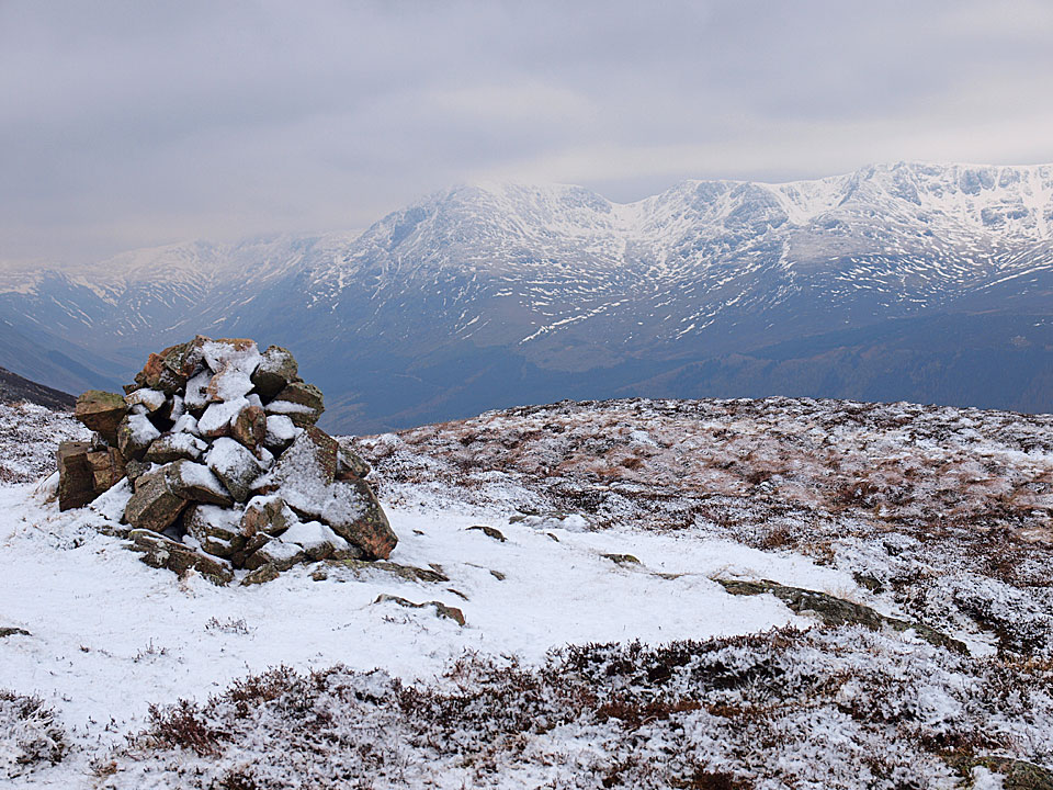
Herdus summit
Height: 562 metres / 1844 feet Grid reference: NY 11759 16344
Herdus summit
Start point: Bowness Knott Car Park (NY 109 153)
Bowness Knott Car Park – Herdus – Great Borne – Starling Dodd – Little Dodd (Ennerdale) – Bowness Knott Car Park
Distance: 7.2 miles Total Ascent: 735 metres Time Taken: 3 hours 30 minutes
Weather: Cold wind, snow. 2°C
Today was a typical January day – cold and windy with snow and a grey, dull and flat light. There was fresh snow above 500m and the wind was raw yet the walk was still enjoyable. I can scarcely believe it is 3 years since I walked over these fells – where does the time go?

Crag Fell over Bowness.

Following the road towards Herdus - I followed the wall beyond the far trees directly ahead before climbing the path through the bracken to the left of the photo. From there the climb was a steep one.

Crossing Rake Beck.

Crag Fell and Anglers' Crag across Ennerdale Water.

There was a lot of forestry work going on around the car park at Bowness and Bowness Knott looks a bit more accessible now than it was with all the trees gone.

Up above the snowline at the top of Herdus. The snow was constantly falling now and throughout the walk.

Heading for Great Borne across an icing sugar topped Herdus, Casper and Dougal try to blend in with the background.

The frozen summit of Great Borne with the pointed Red Pike in view.

Mellbreak and Grasmoor from Great Borne. Dougal has the bit between his teeth now and leads the way.

Looking back to Great Borne from the climb to Starling Dodd.

Red Pike and High Stile from the familiar twisted ironwork cairn on Starling Dodd.

Any old iron? Casper and Dougal on Starling Dodd.

Starling Dodd cairn.

A photo of contrasts - Grasmoor and Crummock Water from Starling Dodd.

Monochromatic Red Pike.

Moonscape at the top of the descent.

Gillinter Beck.

Pillar across Ennerdale.

A closer view of Pillar with Pillar Rock prominent.

A view into Windgap Cove across Ennerdale to Scoat Fell and Pillar.

Pillar dominated this view along Ennerdale with Green Gable and Great Gable in view.

Ennerdale reflections.


Crag Fell.
Start point: Bowness Knott Car Park (NY 109 153)
Bowness Knott Car Park – Herdus – Great Borne – Starling Dodd – Little Dodd (Ennerdale) – Bowness Knott Car Park
Distance: 7.2 miles Total Ascent: 735 metres Time Taken: 3 hours 30 minutes
Weather: Windy! 10°C.
The mountain weather forecast was for high winds today which would ‘make walking impossible’. Well, they were pretty much right with that one! All seemed so calm and tranquil at valley level too – I feared for Angus and Casper on the Great Borne ridge overlooking Ennerdale as they were getting blown around so much. That aside, I don’t think we did so bad with the weather really. It was good to have Angus back up on the high fells too; I think he had missed it.


Crag Fell and Anglers Crag across Ennerdale Water from the steep climb up to Herdus.

Looking to Floutern Cop, Hen Comb beyond, Mellbreak beyond that and Whiteside and Grasmoor beyond that! Once onto the flat top of Herdus, the wind was really strong - no, make that really, really strong!

I could hardly stand up and the two lightweights of the group were getting blown all over. Here's Angus standing his ground for a minute.

Still in strong wind up onto Great Borne. This photo looking to Gavel Fell was taken from the safety of the wind shelter - it was the only way I could keep the camera still!

Heading for Starling Dodd, beyond is Red Pike and the High Stile ridge.

Grasmoor manages to catch the only sunshine of the day.

Looking into Mosedale, Hen Comb to the left and Mellbreak to the right. In the distance are the Loweswater Fells.

Mellbreak with Grasmoor across Crummock Water.

A close-up of Grasmoor.

The cairns on Starling Dodd. Where was this photo taken from?...

...well, we were lying on the floor - of course!

Red Pike and High Stile over the small bump of Little Dodd where we made a hasty exit from the high ridge down to the right.

Robinson and Red Pike from Little Dodd.

Pillar, Scoat Fell and Steeple from the descent to Ennerdale.

Still windy on the descent, though not half as bad as it was up there.

A gloomy looking Pillar, Pillar Rock silhouetted below the cloud.

Ominous looking Green Gable and Great Gable at the head of Ennerdale

Ennerdale.

Crag Fell and Anglers Crag across Ennerdale Water just before the heavens opened - fortunately I was back in the car by then.
Start point: Bleach Green, Ennerdale (NY 085 153)
Bleach Green – Bowness – Brown How (Ennerdale) – Herdus – Great Borne – Gale Fell – Starling Dodd – Little Dodd (Ennerdale) – Red Pike (Buttermere) (357) – High Stile (358) – High Crag (359) – Haystacks (360) – Looking Stead – High Level Traverse – Shamrock Traverse – Pillar – Black Crag (Pillar) – Scoat Fell – Steeple – Haycock – Little Gowder Crag – Caw Fell – Ennerdale Fell – Crag Fell – Bleach Green
Distance: 23.6 miles Total Ascent: 2864 metres Time Taken: 10 hour 20 minutes
Weather: Mainly sunny with lots of snow (!) showers. 7-11°C, valley level – much colder on the tops.
Today’s walk is a long, high level circuit of the beautiful Ennerdale Valley with virtually the whole route being completed at an elevation in excess of 500m. I have had this one on my list of ‘to do’ walks for a while so it was satisfying to complete the walk on a mainly clear day. The photo’s here actually belie the conditions somewhat as the clouds came in when I was crossing from Haystacks to Pillar and there was an icy blizzard. The snow showers continued to come and go throughout the rest of the walk and conditions remained very cold.

Ennerdale Circuit route map.

An early morning silhouette of Ennerdale.

The sunlight on Crag Fell.

A good view from Red Pike of the round completed last Thursday.

Crummock Water from Red Pike.

High Snockrigg and Robinson over Buttermere with Bleaberry Tarn in the foreground.

Looking from High Stile across Bleaberry Tarn and Red Pike to Mellbreak and Crummock Water. Loweswater is visible in the distance.

The sun lights up Pillar Rock across Ennerdale on the north face of Pillar - from High Crag.


Fleetwith Pike and Dale Head from High Crag.

High Crag from Haystacks with Ennerdale to the left and the Buttermere Valley to the right.

Green Gable, Great Gable and Kirk Fell at the head of Ennerdale from Haystacks. The clouds were ominously creeping up behind me now and minutes later this view was obliterated by a blizzard.

Thankfully it had cleared up again by the time I reached the High Level Traverse of Pillar. This is a view of Pillar Rock from Pillar.


The east face of Steeple from Black Crag.

Steeple again, from Scoat Fell across Mirk Cove.

Pillar from Steeple. Steeple is a lofty, airy pinnacle and it's shape makes it feel as though you are in mid-air - one of my favourites.

Steeple, Pillar and Scoat Fell from Haycock.

The barren Caw Fell from Little Gowder Crag.

Pillar, Scoat Fell, Little Gowder Crag and Haycock from Caw Fell.

Ennerdale from Crag Fell.
Start point: Bowness Knott Car Park (NY 109 153)
Bowness Knott Car Park – Bowness Knott (148) – Brown How (Ennerdale) (149) – Herdus (150) – Great Borne (151) – Gale Fell (152) – Starling Dodd (153) – Little Dodd (Ennerdale) (154) – Bowness Knott Car Park
Weather: Dull and overcast with the odd sunny spell.
Today’s walk takes in part of the High Stile group of fells from Ennerdale Water.


Herdus looms ahead from the Bowness Knott car park - it looks a daunting prospect from here.

The sun shines! Crag Fell across Ennerdale Water from the summit of Bowness Knott.

Sun Rays across the head of Ennerdale Water from the summit of Brown How.

Looking along the Ennerdale valley from the summit of Herdus; Great Borne and Starling Dodd to the left, Great Gable in the cloud, centre, and Pillar to the right.

Fellbarrow from the summit of Great Borne.

Starling Dodd from the top of Gale Fell, the summit being marked by the fence corner post. This summit is un-named on O.S maps.

Mellbreak, Whiteside Pike and Grasmoor from the summit of Starling Dodd.

Looking back to Starling Dodd from the summit of Little Dodd.

Ennerdale Water and valley from the descent of Little Dodd.

Pillar, Scoat Fell and Steeple across Ennerdale.

Rowan berries caught in the sunshine.

Crag Fell and Anglers Crag from the shore of Ennerdale Water.