Height: 802 metres / 2631 feet Grid reference: NY 44826 13453 Category: The Far Eastern Fells
High Raise
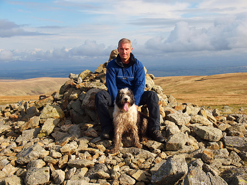
Me with Casper on High Raise – my third completion of the 214 Wainwrights
Height: 802 metres / 2631 feet Grid reference: NY 44826 13453 Category: The Far Eastern Fells
High Raise
Me with Casper on High Raise – my third completion of the 214 Wainwrights
Start point: Mardale Head (NY 469 107)
Mardale Head – Rough Crag (Riggindale) – Caspel Gate – Long Stile – High Street – Straits of Riggindale – The Knott – Rampsgill Head – Kidsty Pike –High Raise – Low Raise – Castle Crag (Mardale) – The Rigg – Mardale Head
Distance: 8.5 miles Total Ascent: 888m metres Time Taken: 4 hours 30 minutes Start Time: 07:00
Weather: Sunny spells. 11oC.
It was beautiful this morning, very still and sunny and it was pleasantly warm climbing Rough Crag but as soon as I got to the High Street plateau it was covered with cloud which made it feel a lot cooler. It was a great day for it though and we were in total solitude throughout with just deer and sheep for company.


Calm reflections on Haweswater.

Harter Fell.

Haweswater from the Rough Crag ridge.

Harter Fell from higher up.

Small Water is nestling somewhere in the combe to the left and Mardale Ill Bell.

Fabulous views today.

A glimpse of Small Water.

Blea Water from Rough Crag.

One mucky pup!

Long Stile, the climb to High Street.

Blea Water.

Long Stile over Caspel Gate.

Caspel Gate Tarn.

There were some lovely sunny spells and it was quite warm when the sun was out.

Looking down Long Stile.

On High Street though it was suddenly cloud covered and felt a lot cooler.

High Street summit looking to Helvellyn.

Hayeswater.

Looking back to High Street.

The Knott.

The Knott summit cairn.

Rest Dodd and The Nab with Ullswater catching the sun in the distance.

High Street and Thornthwaite Crag from Rampsgill Head.

Ramps Gill from Ramspgill Head.

High Street from Kidsty Pike.

High Raise.

Low Raise...back in the sunshine!

Haweswater from the south-east ridge.

Descending the south-east ridge. If you find a lens cap along here it could well be mine!

The British Fort on the south-east ridge with Haweswater beyond.

The view from The British Fort.

Riggindale.

On the way home, the head of Haweswater. Select on the image to see a larger version. This photo will be available as a premium canvas print, e-mail me if you are interested for sizes etc.
Start point: Martindale Old Church (NY 434 184)
Martindale Old Church – Beda Fell – Angletarn Pikes – Angle Tarn – Brock Crags – Satura Crag – Rest Dodd – The Knott – Rampsgill Head – Kidsty Pike – High Raise – Red Crag – Martindale Old Church
Distance: 10.6 miles Total Ascent: 1048 metres Time Taken: 5 hours 40 minutes
Weather: Long sunny spells. 13C.
Today I was joined by StridingEdge stalwarts Andy Lang and Gary Jones for a circuit of Martindale. The occasion was to take in my final two Wainwrights to complete my third time round them, namely Beda Fell and High Raise. After the early mist lifted, the sun shone making it a great end to the walk and of course to completion of the 642!

Martindale Round route map.

Dawn at Martindale Old Church.

Beda Fell beyond Christy Bridge.

Howe Grain from the climb to Beda Fell. There was a definite nip in the air this morning.

The view to Ullswater along Boredale from the ridge to Beda head.

The mist is forming over Ullswater and creeping up the valleys.

As we climb higher the mist completely circles Hallin Fell, here with Winter Crag in the foreground.

The view from higher up the ridge.

Place Fell and St. Sunday Crag from the first cairn on the summit ridge.

Beda Head, the summit of Beda Fell with Hallin Fell, Bonscale Pike and Steel Knotts in view.

A bit of sunshine on Place Fell.

Looking back to Beda Head now drenched in early morning sun.

Walking the ridge to Angletarn Pikes.

Bannerdale just before the mist started pouring over the tops from the south and obliterated everything for a while.

Looking towards Glenridding and Ullswater from Angletarn Pikes.

The mist starting to clear at Angle Tarn.

Angletarn Pikes from the climb to Brock Crags - all clear now!

Angle Tarn in sunshine but Angletarn Pikes in mist again, showing how quickly conditions were changing.

Brothers Water from Brock Crags.

Gray Crag and Hayeswater with some dramatic clouds pouring over High Street and Caudale Moor.

Martindale from Satura Crag.

Today's walk was to a background chorus of rutting stags bellowing around Martindale. We saw many smaller herds of deer but were fortunate to see this stag on the horizon.

Brock Crags from the climb to Rest Dodd.

Casper on the summit of Rest Dodd.

Rest Dodd from the start of the climb to the Knott.

High Street from The Knott.

Hayeswater Gill and Hayeswater from The Knott.

Looking across to The Knott from the crossing to Rampsgill Head.

High Street from the summit of Rampsgill Head.

High Raise and blue skies ahead.

Andy, Gary and Casper crossing to Kidsty Pike.

Riggindale and a glimpse of Haweswater from Kidsty Pike.

No sign of the Golden Eagle but the Casper has landed.

Still tarn below High Raise.

Golden sunshine once more on the summit of High Raise.

Me with Casper on High Raise, my third completion of the 214 Wainwrights.

Following the High Street ridge to Red Crag.

Redcrag Tarn.

Looking over to Helvellyn from Red Crag.

The descent back into Martindale.

Ullswater along Fusedale Beck.

Steel Knotts ahead but we descended the path to the left of the summit.

Beda Fell across Martindale.

All is lovely now on Steel Knotts.

Beda Fell from Martindale Old Church.

Ullswater on the way home.
Start point: Mardale Head (NY 469 107)
Mardale Head – The Rigg – Rough Crag (Riggindale) – Caspel Gate – Long Stile – High Street – Straits of Riggindale – Rampsgill Head – Kidsty Pike – High Raise (497) – Low Raise (498) – Castle Crag (Mardale) (499) – The Rigg – Mardale Head
Distance: 10.2 miles Total Ascent: 1085 metres Time Taken: 4 hours 15 minutes
Weather: Sunny, a glorious Autumn day. 16oC.
I nearly never bothered today, it was wet and miserable first thing this morning but a chance hearing of the weather report on the radio made me get out as it was supposedly brightening during the day. I could hardly believe my luck as I reached Mardale, for the sun was shining and the skies were blue. This was a really enjoyable round (helped by the weather of course!) taking the direct route to High Street via Rough Crag, walking along the Roman Road, trying and failing to spot the Riggindale Golden Eagles and finishing off on the ancient British Fort on Castle Crag above Haweswater.


The ridge route for today's walk over Rough Crag and up to High Street, here seen over Haweswater.

Harter Fell at the head of Mardale.

Mardale Ill Bell.

Mardale Beck in spate, as were all the watercourses in the area due to recent heavy rain.

Harter Fell from The Rigg.

Looking across Haweswater to Lady's Seat and Castle Crag, the route used in descent from Low Raise later.

Riggindale and the Mardale skyline.

Haweswater from the steep climb to Rough Crag.

Mardale Waters from the Rough Crag ridge - Small Water is in the cirque to the left, Blea Water in the one to the right.

Some warm Autumn sunshine on Rough Crag for Casper and Angus.

Blea Water, High Street above.

Looking across Riggindale to Kidsty Pike.

Haweswater Reservoir and Mardale from Rough Crag - Golden Eagles nest on the crags here, the only pair in England. The valley was flooded in the 1930's to create a reservoir for Manchester and the village of Mardale was lost under the water forever.

Long Stile leading to High Street over Caspel Gate.

Looking back to Rough Crag, Branstree in view over the tarn.

Rough Crag from Long Stile.

A sparkling Blea Water, Harter Fell beyond.

Looking along Riggindale to Mardale.

The summit of High Street, deserted today.

Looking south-west to the Coniston fells in the distance, Red Screes and the Fairfield group in the middle distance.

A closer shot of Fairfield. Great Gable and the Scafell range are in the left distance.

The shadows of the three amigos looking to Hayeswater.

...and the uncluttered version.

Walking along the Roman Road to the Straits of Riggindale.

Kidsty Pike from Twopenny Crag.

Ramps Gill from Rampsgill Head, The Nab to the left.

The eastern fells from Rampsgill Head.

We could hear the bellowing of the stags in Martindale Deer Forest below - they certainly caught the attention of Angus.

Where Eagles Dare - Angus on Kidsty Pike, well known perch of the Golden Eagles.

Looking across to the Helvellyn massif from the path to High Raise.

Fairfield from High Raise, Great Gable on the distant right.

Helvellyn from High Raise. Striding Edge is the ridge in the centre with Swirral Edge and Catstycam to the right.

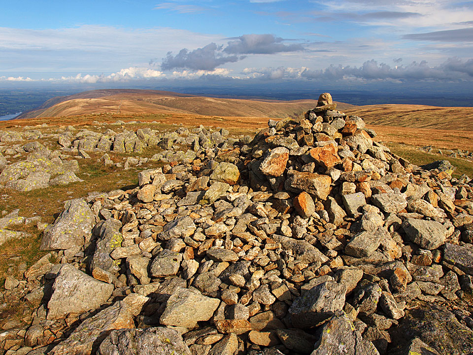
The rock littered summit of High Raise.

The tumulus and cairn on Low Raise.

Haweswater from Lady's Seat and the magnificently situated ancient British fort atop Castle Crag in the foreground.

Whelter Bottom from Castle Crag.

Haweswater from the ruins of the fort.

Still lots of sunshine for the boys to soak up.

Crossing Randale Beck.