Height: 374 metres / 1227 feet Grid reference: NY 21986 23339
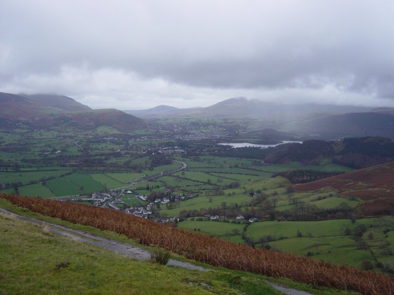
Looking towards Keswick and Derwent Water from the top of Kinn
Height: 374 metres / 1227 feet Grid reference: NY 21986 23339
Looking towards Keswick and Derwent Water from the top of Kinn
Start point: Braithwaite (NY 227 237)
Braithwaite – Kinn – Grisedale Pike – Hobcarton Head – Hopegill Head – Sand Hill – Coledale Hause – Coledale – Braithwaite
Distance: 7 miles Total Ascent: 843 metres Time Taken: 3 hours 30 minutes Start Time: 10:15
Weather: Cold with a strong wind. 3°C
With a break in the weather and a bit of sunshine around, Grisedale Pike looked very tempting from Keswick today wearing its best winter coat. The predicted weather as for high winds with a wind chill of -18C and so it turned out in the end – I didn’t fancy the full Coledale round once I had been up high for a while so took the valley route from Coledale Hause. As the old saying goes “Half a Coledale is better than no Coledale at all”! Once again it was just me and young Dougal whilst Casper stayed at home in the warm – sensible boy!


Before the walk...a wintry view along Windermere from Bowness Bay.

Skiddaw from Braithwaite.

A panoramic view of Skiddaw.

Causey Pike beyond Barrow from the climb to Kinn.

Cold Coledale.

Grisedale Pike.

Dougal checks out the climb.

Sail in mono.

Sunshine and cloud.

Eel Crag and the Coledale Valley.

The climb to Grisedale Pike up Sleet How...spot the Dougal?!

Kinn, Skiddaw and the Vale of Keswick.

Climbers ahead on Sleet How.

Looking back down from Sleet How.

The summit of Grisedale Pike - with a bitter, strong wind, it really was as cold as it looks.

A winter panorama.

The view across Outerside and Causey Pike.

Grasmoor beyond Hobcarton Head.

Dougal surveys the head of Coledale.

On the descent, first heading for Hobcarton Head then Hopegill Head up to the right.

Lovely winter scenery but oh-so cold.

Walkers on Hobcarton Head give some scale to the scene.

Looking back to Grisedale Pike, Skiddaw beyond from Hobcarton Head.

Grasmoor.

Hopegill Head and Ladyside Pike.

Grisedale Pike from the climb to Hopegill Head.

Whiteside and a glimpse of Crummock Water from Hopegill Head summit.

Wandope.

The cloud is starting to cover the fells to the south and east now.

Eel Crag from Sand Hill.

Skiddaw and Blencathra along the Coledale Valley.

Force Crag mine.
Start point: Braithwaite (NY 227 237)
Braithwaite – Kinn – Grisedale Pike – Hobcarton Head – Hopegill Head – Sand Hill – Coledale Hause – Crag Hill – Sail – Scar Crags – Causey Pike – Outerside – Stile End – Barrow – Braithwaite
Distance: 9.8 miles Total Ascent: 1400 metres Time Taken: 4 hours 35 minutes Start Time: 07:00
Weather: Brightening, warm. 18°C
A heat wave was predicted for today and continuing over the weekend – well, it was indeed pretty warm but there was plenty of cloud cover around all morning with it only clearing (predictably) when I reached the end of the walk. It was a pleasant round though, not too warm and I was out early enough to miss most of the crowds that were sure to be out later.

Coledale route map.

Dullsville at the start of the walk, Skiddaw is under there somewhere.

On Kinn.

A touch of brightness beginning to show on the climb to Grisedale Pike.

The mist was swirling and rising from the valleys now, looking across to Outerside and Causey Pike.

Sunburst through the mist.

Looking back at the path just climbed.

Dougal and Casper on the rivet that marks the summit of Grisedale Pike.

Hobcarton Head with Hopegill Head beyond lost in cloud.

Hobcarton Crag and Ladyside Pike.

Looking back to Grisedale Pike.

Sunshine at Coledale Hause looking to Eel Crag on Crag Hill. That way straight up looks interesting and I have never been that way so I think a bit of a scramble is called for.

Yes Dougal, up that-a way! I enjoyed the scramble up here, it was a good way up.

Sand Hill across Coledale Hause.

Climbing Eel Crag.

Casper on the edge of Coledale.

The summit of Crag Hill.

Wandope and Sail Beck from The Scar.

The summit of Sail.

The descent towards Scar Crags and Causey Pike.

Fix the Fells? Fix the Fells!

Ruin them, more like.

Sail and Crag Hill from Scar Crags.

Causey Pike ahead.

Looking across Coledale to Hopegill Head and Grisedale Pike.

Hindscarth and Robinson.

Derwent Water from Causey Pike.

A panoramic view from Causey Pike.

Sail and Crag Hill from Outerside.

Causey Pike from Stile End.

Barrow and Barrow Door.

Suddenly it is starting to clear up on the summit of Barrow.

Catbells.

A panoramic view from the descent.

Clearing skies now on the descent from Barrow.

Cooling off in Coledale Beck. Later, at Low Wood it is a beautiful day and 22C...


Start point: Braithwaite (NY 227 237)
Braithwaite – Kinn – Grisedale Pike – Hobcarton Head – Hopegill Head – Sand Hill – Coledale Hause – Crag Hill – Sail – Scar Crags – Causey Pike – Outerside – Stile End – Barrow – Braithwaite
Distance: 11 miles Total Ascent: 1430 metres Time Taken: 4 hours 35 minutes
Weather: Initially dull and cool turning to blue skies and sunshine. 12oC.
It was certainly a day of two halves today – the ascent to Grisedale Pike was done under dull skies with an increasingly cold wind that lasted until the descent of Sail when the skies ahead suddenly started clearing to reveal blue skies and sunshine. It wasn’t quite what we had last week, but I wasn’t complaining – it could have been much worse.


Skiddaw from the climb up to Kinn.

Looking across Coledale to Barrow and Causey Pike.

The steep ascent to Grisedale Pike.

...and from further up.

Sail and Crag Hill at the head of Coledale, Force Crag mine workings below.

Looking back along the eastern ridge used to climb Grisedale Pike.

Sand Hill and Hopegill Head.

Crag Hill.

Looking back to Grisedale Pike from Hobcarton Head.

Whiteside from Hopegill Head, Crummock Water and Mellbreak in view to the left.

Casper on Hopegill Head.

Looking across Coledale Hause to Crag Hill, the path used in ascent leads off to the right.

Outerside and Causey Pike.

'She'll carry on through it all, she's a waterfall...'

Sunrays over High Snockrigg and Wandope.

The sun lights up Outerside from a misty Crag Hill summit.

Angus shows how windy it was on Crag Hill. It was a cold blast too.

More sunrays on Knott Rigg.

As if by magic...blue sky and sun appear descending from Sail towards Scar Crags. Outerside, Stile End and Barrow are the three peaks in the centre with the bulk of Skiddaw and Blencathra beyond.

Causey Pike from Scar Crags. Blencathra is to the left then Great Mell Fell, Clough Head and Great Dodd.

Looking back along the ridge just descended to Crag Hill, the summit still in cloud.

Skiddaw over Barrow.

'Here's to you (Mrs) Robinson.'!

Clough Head and Great Dodd across Derwent Water from the summit of Outerside.

Clough Head.

Blencathra.

Stile End and Barrow.

Angus and Casper have a drink in the tarn on the way to Stile End.

Barrow from Stile End.

Cat Bells from Barrow.

Looking across Derwent Water to Bleaberry Fell with The Dodds and the Helvellyn ridge beyond, the skies still improving.

Sunburst over Causey Pike.

Bassenthwaite Lake and Braithwaite from the descent of Barrow.

A final view of Skiddaw.
Start point: Braithwaite (NY 227 237)
Braithwaite – Kinn (209) – Grisedale Pike (210) – Hobcarton Head (211) – Hopegill Head (212)– Sand Hill (213) – Coledale Hause – Crag Hill (214) – Sail (215) – Scar Crags (216) – Causey Pike(217) – Outerside (218) – Stile End (219) – Barrow (220) – Braithwaite
Weather: Snow from the ascent of Grisedale Pike.
Today’s walk takes in a circuit of the Coledale Fells. The weather conditions didn’t look too promising from the valley, but it wasn’t so bad considering. The snowy, wintery conditions made a pleasant change from the recent downpours.


Looking towards Keswick and Derwent Water from the top of Kinn. Latrigg and Great Mell Fell are visible in the centre

Causey Pike and Scar Crags behind Outerside from the ascent of Grisedale Pike.

Snow clouds forming on the steep path to Grisedale Pike.

Roses marking the summit of Grisedale Pike...

the summit cairn of Hobcarton End.

The clouds clear momentarily on Sand Hill to allow a glimpse of Crummock Water and Mellbreak, Grasmoor is to the left.

The Coledale valley from Coledale Hause.

A snowy Scar Crags on the descent from Sail.

Looking back along the Causey Pike - Scar Crags ridge from the summit of Causey Pike.

Barrow and Derwent Water from a blizzardy Outerside summit.

Barrow from Stile End summit.

Bassenthwaite Lake behind Braithwaite How and Braithwaite.
