Height: 633 metres / 2077 feet Grid reference: NY 31059 29231 Category: The Northern Fells
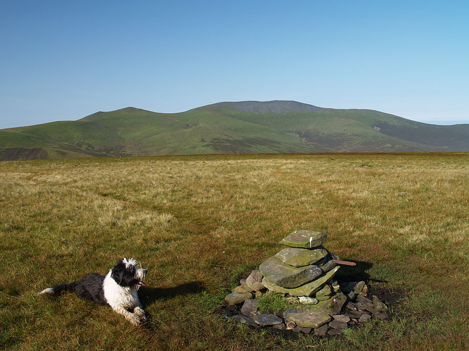
The grassy summit of Mungrisdale Common, with Skiddaw in the background
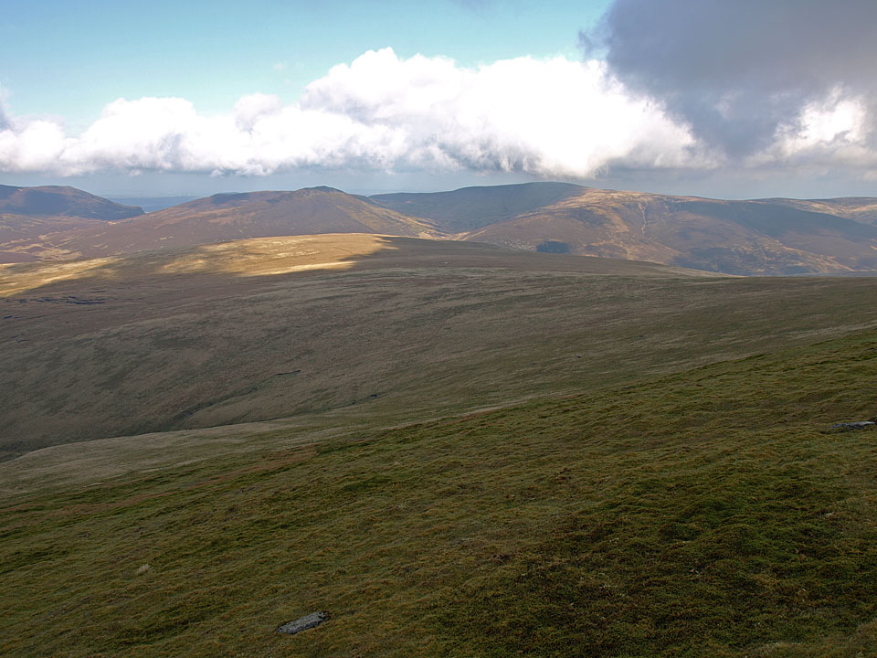
Mungrisdale Common from the slopes of Blencathra
Height: 633 metres / 2077 feet Grid reference: NY 31059 29231 Category: The Northern Fells
The grassy summit of Mungrisdale Common, with Skiddaw in the background
Mungrisdale Common from the slopes of Blencathra
Start point: Threlkeld (NY 318 256)
Threlkeld – Hall’s Fell Ridge – Blencathra – Mungrisdale Common – Great Calva – Skiddaw House – Blencathra Centre – Threlkeld
Distance: 10.7 miles Total Ascent: 1123 metres Time Taken: 5 hours
Weather: Sunny spells, cold on the tops. 12°C.
Blencathra was not even considered when I set out from home this morning but when I saw it I knew I had to climb it. I decided on Hall’s Fell Ridge as it must be a good 10 years since I have climbed this way, the bonus of it is that it climbs directly to the summit cairn. After that I just made it up as I went along and it turned out to be quite a pleasant walk although towards the end it looked as though I might get a soaking as the clouds thickened and hovered ominously overhead, but in the end I thankfully made it back dry.

Blencathra via Hall's Fell Ridge route map.

Early morning at Threlkeld heading for Hall's Fell. The summit of Blencathra is the point at the top of Hall's Fell Ridge.

Blencathra panoramic.

Crossing Gate Gill.

Doddick Fell from the climb.

The mist was constantly swirling around Hall's Fell then lifting giving some enticing glimpses of the way ahead.

Hall's Fell Ridge.

Further along.

There is some excellent scrambling sections along here and the Hall's Fell Ridge makes a great alternative to the more popular Sharp Edge.

Casper the scrambler.

Narrow Edge.

Looking back down the ridge.

From further up with Clough Head and Thirlmere in view.

The summit of Blencathra.

It looks like there is plenty of sunshine over on Mungrisdale Common, so that's where we'll go Casper!

Lonscale Fell along Roughten Gill.

It is all cloudy over on Skiddaw from the cairn on Mungrisdale Common.

It looks like there is plenty of sunshine on Great Calva now Casper, so that's where we'll head for next!

There was one small problem and that was how to cross the River Caldew - wade or jump? I used the tried and tested method of trying break the Olympic long jump record - which worked out rather well as I made it across with dry feet!

One of the circular sheepfolds of Skiddaw Forest, Lonscale Fell behind.

Wiley Gill and Knott from the foot of Great Calva.

The view from Great Calva along the deep geological trough that runs to the south.

Casper in the sun, Knott behind.

Skiddaw from the descent.

Skiddaw House and Lonscale Fell catch the sun.

Heading for Skiddaw House YHA.

Great Calva from Skiddaw House.

Lonscale Fell.

Leaden skies now looking back along the Glenderaterra Valley.

High Rigg and Tewet Tarn from the path to the Blencathra Centre on Blease Fell.

Bluebells at the Blencathra Centre.
Start point: Mungrisdale (NY 361 303)
Mungrisdale – Souther Fell – Scales Tarn – Sharp Edge – Blencathra – Mungrisdale Common – Bannerdale Crags – Bowscale Fell – East Top on Bowscale Fell – Mungrisdale
Distance: 10.4 miles Total Ascent: 960 metres Time Taken: 4 hours 30 minutes
Weather: Sunny and bright. 18oC.
It was an early start again today, climbing Souther Fell with the sun rising across the low lying mist. By the time I reached Scales Tarn for the start of the climb of Sharp Edge, the sun was shining and the weather was glorious with lovely clear views all around; a glorious walk on a glorious day.


Sunrise in Mungrisdale at the start of the climb to Souther Fell, Little Mell Fell and Great Mell Fell in view.

There was lots of early morning mist this morning lying in the valleys.

Mungrisdale mist.

The Bowscale Fell ridge from Souther Fell. The final route of ascent later will be along it.

The summit of Souther Fell looking to Clough Head and the Dodds.

Blencathra clearly showing where the alternative name of Saddleback comes from with Bannerdale Crags in the foreground.

A lie down after the steep warm-up for Casper.

Blencathra from the southern cairn on Souther Fell.


A first glimpse of Sharp Edge from Mousthwaite Comb - it is the light band of rock arcing upwards to the highest pinnacle and looks almost impossible to climb from here.

Sharp Edge above Scales Tarn - it doesn't look quite as bad now.

The approach to Sharp Edge.

Up there?!

Climbing Sharp Edge.

Casper negotiates some of the slabs.

...and looking back down.

High above Scales Tarn now.

Made it! A lovely clear view from the summit of Blencathra today. To the north there were views to Scotland over low lying mist.

Wisps of cloud hang around on Hall's Fell Ridge.

The north western fells above Derwent Water and Keswick.

Casper.

Skiddaw from the summit tarn on Blencathra.

The Skiddaw massif across Mungrisdale Common.

Mungrisdale Common, that most derided of Wainwright fells as it is merely a large and grassy expanse with not a lot going for it - apart from today that is because Casper is there to liven the scene up! (Note: he is not there every day, unfortunately).

Sharp Edge from the climb to Bannerdale Crags, here seen rising from the centre up to the right.

Blencathra from the summit of Bannerdale Crags.

Looking east from the summit of Bowscale Fell.

Looking over Bowscale Tarn to Mosedale and High Pike from the East Top of Bowscale Fell.

Carrock Fell from the east ridge of Bowscale Fell.

Souther Fell from the descent across a sea of bracken.
Start point: Bowscale (NY 358 317)
Bowscale – Bowscale Tarn – East Top on Bowscale Fell (387) – Bowscale Fell (388) – The Tongue (389) – Bannerdale Crags (390) – Blencathra – Mungrisdale Common – Cloven Stone – Lonscale Pike (391) – Lonscale Fell (392) – Jenkin Hill (393) – Skiddaw Lesser Man (394) – Skiddaw Little Man (395) – Skiddaw – Bakestall – Whitewater Dash – Little Calva (396) – Knott – Coomb Height (397) – Little Lingy Hill (398) – Great Lingy Hill (399) – Hare Stones (400) – High Pike (401) – Miton Hill (402) – Round Knott (403) – Carrock Fell (404) – Mungrisdale – Bowscale
Distance: 25.8 miles Total Ascent: 2447 metres Time Taken: 10 hours 50 minutes
Weather: Sunny and warm with a slight breeze. 25°C.
Today’s walk was a long circuit of the quiet fells known as ‘The Back o’ Skiddaw’. The weather was very pleasant, not as hot and muggy as it has been recently with a slight, welcome, cooling breeze. The views were absolutely superb at times and I was glad I chose today to do this long walk. The only problem was I forgot my food and 26 miles is a long way without any fuel…

Back O' Skiddaw route map.

Early morning light on Carrock Fell. This was to be the last fell of the walk, some 11 long hours later.

Looking along the Mosedale valley.

Bowscale Tarn, keeper of two immortal fish so legend has it and mentioned by Wordsworth in his poem 'Song at the Feast of Brougham Castle', 1807. '...And both the undying fish that swim, Through Bowscale Tarn did wait on him, The pair were servants of his eye, In their immortality, They moved about in open sight, To and fro, for his delight...'

Strange light and a band of thick low lying cloud to the south from Bowscale Fell's subsidiary east top.

The north western fells seen between Blencathra and Skiddaw.

Blencathra from Bannerdale Crags.

Skiddaw across the summit tarn on Blencathra.

The summit of Blencathra.

Skiddaw from that most derided of Wainwright fells (for not being a true summit), Mungrisdale Common.

Lonscale Fell from Mungrisdale Common. It was a sharp drop off from Blencathra down to Mungrisdale Common then an incredibly steep pull to get back up onto Lonscale Fell via Burnt Horse.

Great Calva from the climb to Lonscale Fell.

The view from Lonscale Pike, the east peak of Lonscale Fell. In the centre is High Rigg with Tewet Tarn visible and Thirlmere behind.

Skiddaw Lesser Man. Little Man and Skiddaw from Jenkin Hill.

There were superb, breath taking views from the climb up to Skiddaw.

The north-western fells from Skiddaw.

Bassenthwaite Lake and Sale Fell from Skiddaw. Not as cold as the last time we were here.

The view reached as far as Scotland over the Solway Firth to Criffel.

Binsey along the Dash Valley. To reach this point was another steep drop off from Bakestall down Birkett Edge and then a hard climb following the fence up to Little Lingy Fell.

The path to Knott.

A quick rest on Coomb Height, Carrock Fell in the background.

High Pike had a welcoming seat...

Evening light and the cloud begins to form on Skiddaw, seen from Round Knott.
Mungrisdale – Bannerdale Crags – Mungrisdale Common (177) – Cloven Stone – Mungrisdale Common – White Horse Bent – Souther Fell (178) – Mungrisdale
A clear day at last, there was a cold wind above 500 metres.


Bannerdale Crags on the road from Mungrisdale.

Blencathra appears over the lip of Bannerdale Crags.

Blencathra from Bannerdale Crags summit.

Skiddaw from the 'summit' cairn of Mungrisdale Common.

Derwent Water and the distant Fells from Mungrisdale Common. L-R: Bowfell, Esk Pike Scafell, Lingmell, Great Gable, Kirk Fell, Dale Head, Hindscarth, Pillar, Robinson. In the foreground, Blease Fell is to the left and Lonscale Fell to the right.

'Cloven Stone' - marked on the O.S map and by AW.

White Horse Bent

Sharp Edge and Blencathra from White Horse Bent.

outhwest from Souther Fell, in the foreground Clough Head is to the left, Blencathra to the right. On the horizon L-R: Crinkle Crags, Bowfell, Esk Pike, Scafell, Lingmell, Great Gable, Brandreth and Kirk Fell.

Blencathra and Scales Fell from the summit of Souther Fell.