Height: 696 metres / 2283 feet Grid reference: NY 43272 13701 Category: The Far Eastern Fells
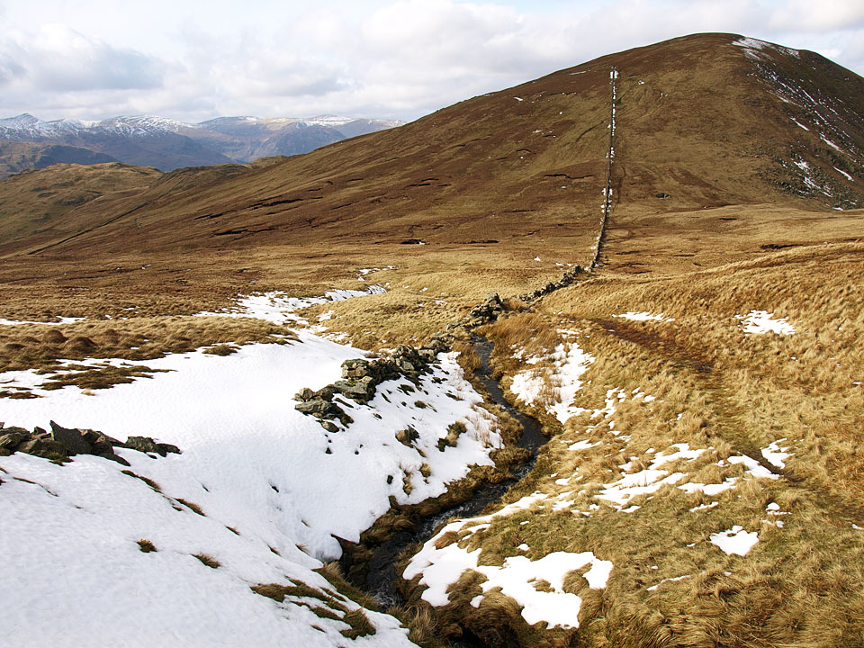
Rampsgill Head from Rest Dodd
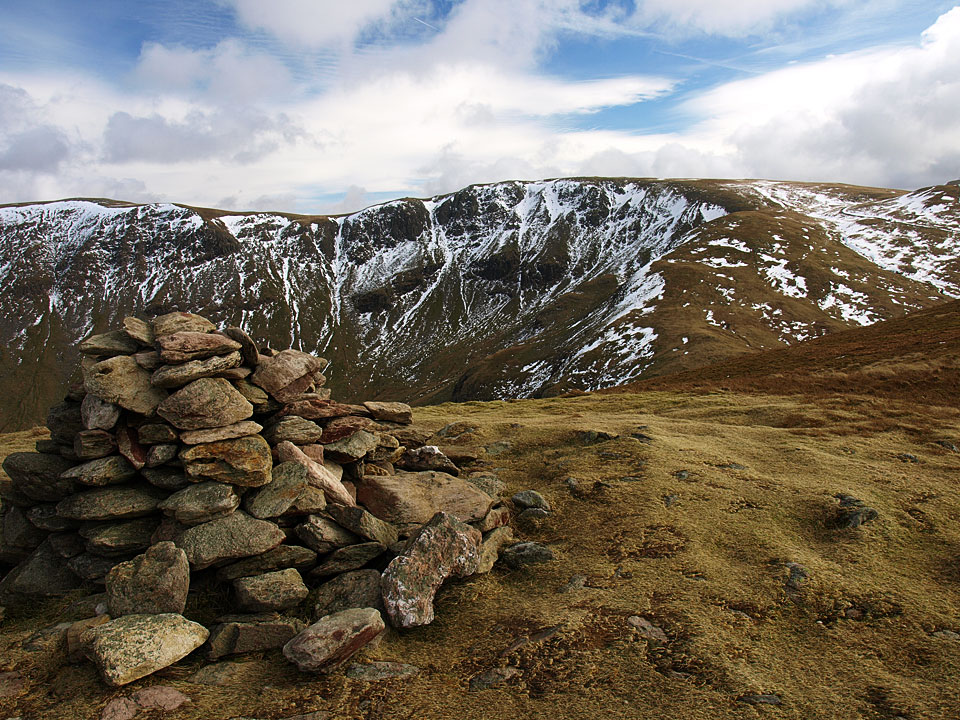
Rest Dodd from The Knott
Height: 696 metres / 2283 feet Grid reference: NY 43272 13701 Category: The Far Eastern Fells
Rampsgill Head from Rest Dodd
Rest Dodd from The Knott
Start point: Hartsop (NY 409 131)
Hartsop – Brock Crags – Satura Crag – Rest Dodd – Hayeswater – Hartsop
Distance: 4.4 miles Total Ascent: 562 metres Time Taken: 2 hours 15 minutes Start Time: 09:50
Weather: Constant showers. 13°C
The weather was a little different to last time I was out, the rain was light but pretty well constant today and most of the tops were hidden beneath the murk. This was a made up on the go walk, I hadn’t intended coming here at all today but it sufficed given the conditions and being a fair weather walker I didn’t get as far as I had intended at the start either.


Gray Crag with the summit looking a bit, well, grey from Hartsop.

Pasture Bottom and Threshthwaite Mouth.

Hartsop Dodd.

Hartsop and Brothers Water from the climb to Brock Crags.

High Street is under the clag above Hayeswater, Gray Crag to the right. The distinct path is the one I used in descent from Hayeswater.

Gray Crag panoramic.

Looking towards Angletarn Pikes and Place Fell from Brock Crags.

The summit of Brock Crags.

Angle Tarn is quiet today.

Casper and Dougal check out what's happening over my shoulder.

Angle Tarn from Satura Crag.

Bannerdale and Beda Fell.

On the climb to Rest Dodd.

The dreaded peat hags on The Nab and a glimpse of Ullswater.

Place Fell.

On the summit of Rest Dodd.

The Knott or not The Knott?

Not, it turned out...as the clag clears briefly.

The descent to Hayeswater.

Hayeswater.

At the outflow from Hayeswater.

A zoom over to Dove Crag.

How green is my valley? The well photographed barn in Hartsop.

Hayeswater Gill.
Start point: Hartsop (NY 409 131)
Hartsop – Brock Crags – Angletarn Pikes – Satura Crag – The Nab – Rest Dodd – Hayeswater Gill – Hartsop
Distance: 7.4 miles Total Ascent: 846 metres Time Taken: 3 hours 15 minutes Start Time: 09:15
Weather: Overcast with spots of rain. 15ºC
After endless days of sunshine and warm weather, this morning was dull and threatened rain constantly. It was good to be back on the high fells and I made it back before the rain eventually came. I ended up doing a few direct routes to places rather than following the paths today for a bit of a change.

Angletarn Pikes route map.

Gray Crag from Hartsop.

Gray Crag again from the foot of the climb.

Brothers Water through the gap.

Hawthorn on the climb.

Place Fell and Angletarn Pikes from Brock Crags.

Angle Tarn.

Going for it Dougal? The view from Cat Crag.

Angle Tarn from the south summit of Angletarn Pikes.

Casper and Dougal on the northern - and highest - summit.

The descent back towards Angle Tarn.

Angle Tarn panoramic - Dougal and Casper are in there having a dip too.

The gateway to Satura Crag and Rest Dodd.

Peat hag nightmare, The Nab.

Deer-y me.

Rest Dodd from The Nab.

It was a bit grey over Ullswater.

Threading a way through the hags, this must be the driest they will ever be.

Phew, that was a steep climb to Rest Dodd.

The wind has whipped up here now as well and there are spots of rain - time to escape.

Descending back to Hartsop the steep way.

Hartsop barn.

Blackthorn.
Start point: Martindale Old Church (NY 434 184)
Martindale Old Church – Beda Fell – Angletarn Pikes – Angle Tarn – Brock Crags – Satura Crag – Rest Dodd – The Knott – Rampsgill Head – Kidsty Pike – High Raise – Red Crag – Martindale Old Church
Distance: 10.6 miles Total Ascent: 1048 metres Time Taken: 5 hours 40 minutes
Weather: Long sunny spells. 13C.
Today I was joined by StridingEdge stalwarts Andy Lang and Gary Jones for a circuit of Martindale. The occasion was to take in my final two Wainwrights to complete my third time round them, namely Beda Fell and High Raise. After the early mist lifted, the sun shone making it a great end to the walk and of course to completion of the 642!

Martindale Round route map.

Dawn at Martindale Old Church.

Beda Fell beyond Christy Bridge.

Howe Grain from the climb to Beda Fell. There was a definite nip in the air this morning.

The view to Ullswater along Boredale from the ridge to Beda head.

The mist is forming over Ullswater and creeping up the valleys.

As we climb higher the mist completely circles Hallin Fell, here with Winter Crag in the foreground.

The view from higher up the ridge.

Place Fell and St. Sunday Crag from the first cairn on the summit ridge.

Beda Head, the summit of Beda Fell with Hallin Fell, Bonscale Pike and Steel Knotts in view.

A bit of sunshine on Place Fell.

Looking back to Beda Head now drenched in early morning sun.

Walking the ridge to Angletarn Pikes.

Bannerdale just before the mist started pouring over the tops from the south and obliterated everything for a while.

Looking towards Glenridding and Ullswater from Angletarn Pikes.

The mist starting to clear at Angle Tarn.

Angletarn Pikes from the climb to Brock Crags - all clear now!

Angle Tarn in sunshine but Angletarn Pikes in mist again, showing how quickly conditions were changing.

Brothers Water from Brock Crags.

Gray Crag and Hayeswater with some dramatic clouds pouring over High Street and Caudale Moor.

Martindale from Satura Crag.

Today's walk was to a background chorus of rutting stags bellowing around Martindale. We saw many smaller herds of deer but were fortunate to see this stag on the horizon.

Brock Crags from the climb to Rest Dodd.

Casper on the summit of Rest Dodd.

Rest Dodd from the start of the climb to the Knott.

High Street from The Knott.

Hayeswater Gill and Hayeswater from The Knott.

Looking across to The Knott from the crossing to Rampsgill Head.

High Street from the summit of Rampsgill Head.

High Raise and blue skies ahead.

Andy, Gary and Casper crossing to Kidsty Pike.

Riggindale and a glimpse of Haweswater from Kidsty Pike.

No sign of the Golden Eagle but the Casper has landed.

Still tarn below High Raise.

Golden sunshine once more on the summit of High Raise.

Me with Casper on High Raise, my third completion of the 214 Wainwrights.

Following the High Street ridge to Red Crag.

Redcrag Tarn.

Looking over to Helvellyn from Red Crag.

The descent back into Martindale.

Ullswater along Fusedale Beck.

Steel Knotts ahead but we descended the path to the left of the summit.

Beda Fell across Martindale.

All is lovely now on Steel Knotts.

Beda Fell from Martindale Old Church.

Ullswater on the way home.
Start point: Hartsop (NY 410 130)
Hartsop – Brock Crags – Satura Crag – The Nab – Rest Dodd – The Knott – Hayeswater – Hartsop
Distance: 8.9 miles Total Ascent: 1178 metres Time Taken: 3 hours 30 minutes
Weather: Overcast with some sunny spells. 9ºC.
It was a bit of an unplanned walk today; I didn’t really know where I was going until I got there and I only ended up at Hartsop due to roadworks at Troutbeck ‘forcing’ me over Kirkstone Pass rather than sitting in a lengthy queue. As it turned out, I was glad I went over that way as there were some decent sunny spells and still a bit of lingering snow even though it was quite warm – all in all a rather pleasant days walking.


Brock Crags from Hartsop. Lots of walls criss-crossing the fellside here.

Gray Crag from the Hartsop valley.

It looks quite promising up on Brock Crags.

Pasture Bottom from the climb to Brock Crags.

Hartsop above How over Brothers Water with Fairfield and Saint Sunday Crag beyond.

Gray Crag.

Hayeswater from Brock Crags, nestling below The Knott, High Street and Gray Crag.

Rest Dodd, The Knott and Rampsgill Head.

The bejewelled summit of Brock Crags with Helvellyn beyond the cairn.

Looking east from Brock Crags summit.

Angle Tarn and Angletarn Pikes with Place Fell distant left and Beda Fell distant right.

Wild Casper above Angle Tarn.

Reflected sun.

Gateway to the fells? Satura Crag.

Looking back to Brock Crags, left.

Climbing to the moon.

The Nab with its notorious peat hags, Wether Hill beyond across Ramps Gill.

The view from The Nab across Angletarn Pikes to Fairfield and Helvellyn.

The view from the crossing of The Nab.

The Nab from the climb to Rest Dodd with the merest glimpse of Ullswater.

Rampsgill Head from Rest Dodd.

The Knott from the descent of Rest Dodd.

Looking back to Rest Dodd.

Rest Dodd and The Nab.

Climbing to The Knott.

Casper looking a bit bedraggled.

High Street and Thornthwaite Crag from The Knott.

Glittering sunshine on Hayeswater.

High Street across Hayeswater.

The weir on Hayeswater.

Hayeswater.

Descending to Hartsop.

Hayeswater Gill.
Start point: Hartsop (NY 410 130)
Hartsop – Brock Crags – Satura Crag – The Nab – Rest Dodd – The Knott – Hayeswater – Hartsop
Distance: 8.9 miles Total Ascent: 1178 metres Time Taken: 3 hours 35 minutes
Weather: Overcast, turning to rain. 6oC.
I thought we might be up in the snow today, but that has all gone apart from a smattering on the highest fells; today it was cold but the precipitation was rain. The day started off promising enough but soon ended up being a bit miserable. We managed to catch sight of a distant herd of Red Deer in Martindale Deer Forest which was a nice sight, but I don’t think Angus and Casper were too bothered.


Gray Crag from the walk along Hayeswater Gill.

Looking along Pasture Bottom to Threshwaite Mouth.

Hartsop Dodd from the climb up to Brock Crags.

Pasture Bottom from higher up.

Gray Crag with Hayeswater now in view. Above Hayeswater is High Street. At the bottom of the photo is the filter house which marks the start of the zigzags to Brock Crags.

Brothers Water and the Hartsop above How ridge from Brock Crags. Behind with a sprinkling of snow is Dove Crag, Hart Crag and Fairfield.

Saint Sunday Crag and the Helvellyn ridge.

'I want to be adored'.

Angletarn Pikes beyond Angle Tarn, Place Fell behind.

Gray Crag again - this time the cloud was pouring over Threshwaite Mouth; this spelled the beginning of the end for the fine weather.

Bannerdale, The Nab to the right.

The Nab, the many loathsome peat hags evident. Beyond is Loadpot Hill with the merest glimpse of Ullswater.

Heading for the summit of The Nab. This is the preferred route walkers are now asked to follow - out and back along the ridge.

Rest Dodd from The Nab.

Having a rest on The Nab - where are all the deer? The greying skies over Rest Dodd show the weather worsening and it was now raining. The steep climb up to Rest Dodd and then over to The Knott was done in rain and mist - so no photos of that section! When we reached the wall that can be seen above Casper's head, we caught a glimpse of the Red Deer herd down below in Ramps Gill.

Rest Dodd from the descent of The Knott.

Rest Dodd and The Nab.

Hayeswater Dam.

Hayeswater Gill. The final sting in the tail for this walk was the herd of bulls standing between us and Hartsop shortly after we crossed the bridge (as any dog owner knows, dogs are cow and bull magnets!). Lots of shouting and fervent waving of arms ensured we survived that one unscathed!
Start point: Hartsop (NY 410 130)
Hartsop – Gray Crag (110) – Thornthwaite Crag (111) – High Street – The Knott (112) – Rest Dodd (113) – The Nab (114) – Satura Crag – Angle Tarn Pike South (115) – Angletarn Pike North (116) – Brock Crags (117) – Hartsop
Weather: Overcast, some rain later.
Another walk chosen by my 13 year old son today, principally to take in some wildlife; the promise of wild ponies on Thornthwaite Crag, a Golden Eagle over Riggindale and deer in the Martindale Deer Forest spurring him into action. Of course, there was also the lure of walking in the footsteps of Roman soldiers across High Street.
From the car park through the hamlet of Hartsop, we followed the old mine road along Hayeswater Gill and over Wath Bridge.


Threshwaite Mouth from the Hayeswater Gill path. We decided to ascend Gray Crag by the direct route - straight up the sickeningly steep nose leading directly to the summit.

The Eastern Fells from the summit of Gray Crag, Catstycam is the conical peak on the right. From the summit, it is a simple stroll along the grassy undulations to Thornthwaite Crag, sometimes referred to as Thornthwaite Beacon due to the distinctive 14 feet high column on its summit.

Thornthwaite Beacon. From the beacon the path U-turns on to the Roman road and follows the gentle rise to the summit of High Street.

Yoke, Ill Bell, Froswick and Windermere from the Roman road on High Street. We then left the Roman road to cross the wall which traverses the summit plateau and headed for the trig. column that marks the highest point.

The summit of High Street looking to Fairfield and Dollywagon Pike. From the summit, we headed over to the Eastern side of the fell to look over Haweswater and along Riggindale with binoculars out trying to spot the Golden Eagle. Oh dear, no wild ponies and no eagle!

Blea Water from High Street

and looking along the Roman road to The Knott and Rest Dodd.

A view along Riggindale to Haweswater. After returning to the Roman road, it was a simple climb to the summit of The Knott.

The Knott summit with Rest Dodd near left and The Nab to the right. From The Knott, a steep descent/ascent following the wall took us to the summit of Rest Dodd.

Rampsgill Head from the summit of Rest Dodd. Again from Rest Dodd, it was straight over the nose and onward over the difficult peat hag terrain of the Deer Forest to The Nab.

The peat hags of the Martindale Deer Forest and The Nab.

Rest Dodd from the summit of The Nab. Then it was back along the same peaty path to the wall - at last we were rewarded with the sight of a deer herd. We then followed the wall over to Satura Crag and then skirted Angle Tarn to ascend the northern top of Angletarn Pikes quickly followed by the southern top as the rain set in.

Hayeswater from Satura Crag,

and Place Fell from the northern top of Angletarn Pikes.

Angle Tarn from the southern summit of Angletarn Pikes. Skirting around the other side of Angle Tarn, we ascended directly to the summit Brock Crags with views over Hartsop and Brothers Water.

Brothers Water from the summit of Brock Crags. From Brock Crags, we followed the old wall straight down to Hayeswater Gill and picked up the grassy path between two walls which led us back to Hartsop.

Did we really climb straight up the face of that! - Gray Crag from the descent of Brock Crags.
Hartsop – Hayeswater – The Knott – Rest Dodd (144) – The Nab (145) – Satura Crag – Angletarn Pikes (146) – Brock Crags (147) – Hartsop

Looking towards Hayeswater from the climb up Hayeswater Gill .

Hayeswater from the ascent of The Knott.

The Knott summit cairn shrouded in mist.

Rest Dodd from the descent of The Knott.

Rest Dodd summit cairn shrouded in mist.

View of The Nab with the peat hags in the foreground.

The Nab summit cairn looking towards Rest Dodd.

Brock Crags summit overlooking Brothers Water.

Angle Tarn from Brock Crags.

Deer on Brock Crags.

Angle Tarn from Angletarn Pikes southern summit.

View of Gray Crag from Brock Crags.

Looking up Pasture Beck to Threshwaite Mouth.