Height: 311 metres / 1020 feet Grid reference: SD 16550 97150 Category: The Outlying Fells
 The view over Seat How, centre, from the descent. The old boathouse is to the left.

Devoke Water from Seat How.
Height: 311 metres / 1020 feet Grid reference: SD 16550 97150 Category: The Outlying Fells
The view over Seat How, centre, from the descent. The old boathouse is to the left.
Devoke Water from Seat How.
Start Point: Birker Fell road (SD 171 977)
Birker Fell Road – Rough Crag (Birker Moor) (OF) – Water Crag (OF) – Seat How (Birker Moor) (OF) – Birker Fell Road
Distance: 3 miles Total Ascent: 190 metres Time Taken: 1 hour 15 minutes Start Time: 14:00
Weather: Warm but overcast, 19°C
I had enough time for a quick walk around Devoke Water this afternoon – it is guaranteed to be far from the madding crowd up here even at the weekend.

Firstly, a few photos from this week (they are available to view on Facebook at the time they are taken if you want to keep up to date). Windermere sunset.

Heaven.

Moon over Helvellyn.

Martian landscape or the west coast of Cumbria?

Setting sun.

Fun and frolics in the last bit of daylight.

Harter Fell and Green Crag. It was a bit of a funny day being really warm hazy and overcast.

Fletcher progress report: he is off the lead on the fells and loving it! He is such a good lad, sticks by my side and not particularly interested in sheep - only out of curiosity really. He is going to be a fell maestro for sure...

Hazy Scafell.

Above Devoke Water.

Heading for Water Crag.

Rough Crag from Water Crag.

Fletcher.

Tongue competition.

Woodend Height and Yoadcastle.

Seat How.

Devoke Water swimming club.

Walking on water.

The old boathouse.

Devoke Water from Seat How.

'Look what I've found!' - not sure of the significance of this on top of Seat How.

Gimmers - a face in the crowd.
Start point: Birker Fell road (SD 171 977)
Seat How (Birker Moor) (OF) and Devoke Water from the Birker Fell road
Weather: Warm and hazy. 22C
This weeks warm and hazy weather continued today and a ‘stroll and swim’ was the desired objective for Connie (freshly enthused by swimming across Windermere from Fell Foot and back twice yesterday!). Once up onto Birker Fell though, conditions were a little different to those at valley level as there was a strong breeze which, although pleasant to walk in, coupled with icy water wasn’t conducive to swimming in!

A hazy view across to Green Crag and Harter Fell.

Seat How, Water Crag and Rough Crag from The Seat.

Scafell, just about visible through the haze.

Heading for Seat How.

Dougal tells Connie to hurry up.

The rock climbers.

There was a surprisingly strong wind up here, not what we were expecting at all.

Woodend Height from Seat How.

Looking towards Harter Fell.

Devoke Water.

The old boathouse.

Water Crag.

Connie, Casper and Dougal on Seat How.

A rocky descent.

Down at the boathouse.

Rough view to Rough Crag.

...and a watery view to Water Crag.

Connie tests the water. Warm enough for a swim? Hmm...

...not really but it was warm enough for a paddle and a few stone skimming lessons for Connie, here looking to Water Crag beyond Watness Coy from in Devoke Water.

We soaked up the sunshine sitting here for a while.

The Angler.
Start point: Birker Fell road (SD 171 977)
Seat How (Birker Moor) (OF) from the Birker Fell road
Weather: Sunny and warm. 20C.
I thought I would keep away from the traffic and crowds today with a walk across Birker Fell up to Yoadcastle. The weather was beautiful – really warm with a slight breeze. I’ll blame it on the weather that I didn’t quite reach my intended destination…

The track to Devoke Water, Seat How is the limp in the centre.

The view towards the Scafells from Tewit Moss, a really boggy area and not a recommended route.

Seat How and Water Crag complete with frolicking Casper!

What a beautiful day up on the top today.

Having a look over Devoke Water.

A panoramic view of Devoke Water. It was so warm and peaceful here today, I had a lie down for a little while enjoying the sunshine...

...and the view when I eventually woke up! All motivation to carry on had gone now so I opted for a quick return.

Hesk Fell, Stickle Pike in the distance.

A panoramic view from The Seat.

Harter Fell, the scene of my last walk.

Great Gable peeps from behind Scafell here (left) with Scafell Pike and Slight Side in view. The flat topped Eskdale Fell is central.

Bowfell.
Start point: Birker Fell road (SD 171 977)
Birker Fell Road – Rough Crag (Birker Moor) (OF) – Water Crag (OF) – Seat How (Birker Moor) (OF) – Birker Fell Road
Distance: 2.8 miles Total Ascent: 190 metres Time Taken: 1 hour 15 minutes
Weather: Overcast with some sunny spells. 17ºC.
The weather has been a bit on and off today and I couldn’t decide where to walk. Eventually I ended up at Devoke Water where there was a cool breeze on the tops to make it feel autumnal and it was quite squelchy underfoot. I think I just managed to dodge the rain today though with heavy downpours either side of the walk.


Harter Fell, Crook Crag and Green Crag from the Birker Fell road.

Woodend Height and the old boathouse from the climb to Rough Crag. The bracken is starting to turn noticeably now and autumn is round the corner. When are we having summer then?

Upper Eskdale, the Scafells in cloud.

Seat How showing ascent by the direct route later.

The view to the east from Rough Crag.

Casper on Rough Crag overlooking Devoke Water.

Water Crag ahead.

Following the leader.

The view from Water Crag - Rough Crag, Harter Fell and Green Crag.

Descending to Devoke Water with the shapely silhouette of Caw in the distance.

It has started to brighten up over this way looking to Seat How but beyond, the Coniston fells are covered in cloud still.

Where did that blue sky come from? Looking back up to Water Crag.

Down at Devoke Water side.

Hesk Fell from Seat How.

Casper in the grass.

Yoadcastle and Woodend Height.

Devoke Water.

Water Crag and Rough Crag above Devoke Water.

Esk Pike and Bowfell, now clear of cloud.

Harter Fell and Green Crag.

Heading for home and just in the nick of time as the weather took a turn for the (much) worse.
Start point: Birker Fell road (SD 171 977)
Birker Fell Road – Rough Crag (Birker Moor) (OF) – Water Crag (OF) – White Pike on Birkby Fell (OF) – Yoadcastle (OF) – Woodend Height (OF)– Seat How (Birker Moor) (OF) – Birker Fell Road
Distance: 5.4 miles Total Ascent: 686 metres Time Taken: 2 hours
Weather: Sunny spells, clearing. Cool breeze on the tops. 20oC.
I think the weather men actually got it right today, saying it would clear throughout the morning as it duly did. Although it was warm when sheltered, the exposed tops were caught by the wind straight off the Irish Sea and made it more than a bit chilly. Brr!


Running to Rough Crag. Well, some of us are.

Harter Fell and Green Crag across Birker Fell.

The Scafells, Esk Pike, Bowfell, Crinkle Crags and Harter fell.

Casper and Angus on top of Rough Crag.

A close-up of Harter Fell.

Scafell and Slight Side, Great Gable in the distance.

Looking to Rough Crag from the walk to Water Crag.

Looking west over Birker Fell, the pyramidal Caw to the right.

Crossing Linbeck Gill, the outflow of Devoke Water.

Devoke Water from an ancient cairn below Birkby Fell.

The west Cumbrian coast and Ravenglass Estuary from White Pike. The River Esk is snaking its way into the estuary.

Admiring the view on White Pike.

The Scafells from the large cairn on Woodend Height.

Yoadcastle and Whitfell from Woodend Height.

I think these two were waiting for me on Yoadcastle.

The view from Yoadcastle.

Looking over White Pike to the coast.

The view over Seat How, centre, from the descent. The old boathouse is to the left.

Water Crag over the old boathouse.

Seat How.

The boathouse from the climb to Seat How.

Devoke Water from Seat How.
Start point: Birker Fell road (SD 171 977)
Birker Fell Road – Devoke Water – Seat How (Birker Moor) (OF) – Birker Fell Road
Weather: Overcast. 11oC
It was very gloomy yet again this morning with the cloud hanging low over the fells. This short and easy walk is a good one which is not too far from the beaten track. There was, however, a sting in the tail for me at the end of this one – read on for details…
Like it large? Have a look at this and see what you think. Which is better, large or standard?

Seat How with a gloomy looking White Pike behind.

Devoke Water looks so cold today - not like when we were here in July.

The old Boathouse and Water Crag.

Someone's been for a swim despite the conditions.

Climbing to Seat How.

Angus and Casper on Seat How.

Rough Crag. Shortly after this photo, I managed to slip on some rocks and banged the camera hard on them - and that, as they say, was that (for the camera that is...RIP!).
Start point: Birker Fell road (SD 171 977)
Birker Fell Road – Rough Crag (Birker Moor) (OF) – Water Crag (OF) – Seat How (Birker Moor) (OF) – Birker Fell Road
Distance: 3.5 miles Total Ascent: 300 metres Time Taken: 1 hour 30 minutes
Weather: Sunny with a cool breeze. 14oC.
I had a short walk this morning around Devoke Water, a largely missed and unvisited stretch of water. This is one which gives fine views, especially on a day that was ever clearing like today. Casper is ever improving as well – now he comes on command, which is good – now I’ve just got to get Angus to do it…!


Seat How, Yoadcastle and Devoke Water from the climb to Rough Crag.

Kirk Fell and Great Gable peeping out from behind Scafell (in cloud).

The view to the Scafell range from Rough Crag.

There was a really stiff, cold breeze up on the exposed tops of Rough Crag and Water Crag. Casper finds a good vantage point here on Rough Crag.

The way ahead to Water Crag.

Looking back to Rough Crag from Water Crag, Harter Fell beyond.

Sunshine for these two to lie in, but it's still windy on Water Crag. Last day of the long hair for Angus too - his summer crop beckons!

Muncaster Fell from Water Crag, Sellafield on the coast in the distance.

Angus had a swim in Devoke Water

Harter Fell, Green Crag and Seat How across Devoke Water.

Devoke Water from Seat How, the old boathouse below.

Angus has a look at the panoramic vista of the Scafells.

Great Gable.

Kirk Fell.

Harter Fell.

The cloud had lifted from the tops now compared to the earlier photos.

Water Crag across Devoke Water.

Harter Fell and Green Crag from the track down to the Birker Moor road.

...and a close up of them.

Kirk Fell, Great Gable and Scafell from the Birker Moor road.
Start point: Birker Fell road (SD 171 977)
Birker Fell Road – Rough Crag (Birker Moor) (OF) – Water Crag (OF) – Seat How (Birker Moor) (OF) – Birker Fell Road
Distance: 3.5 miles Total Ascent: 300 metres Time Taken: 1 hour 30 minutes
Weather: Warm but hazy, gradually clearing, 18°C.
This afternoon I had a short and slow walk on Birker Moor, completing a circuit of the Devoke Water shoreline. It was warm today with a slight breeze; the conditions were hazy so it wasn’t so good for views until the end of the walk. Nice to see a little bit of summer though!

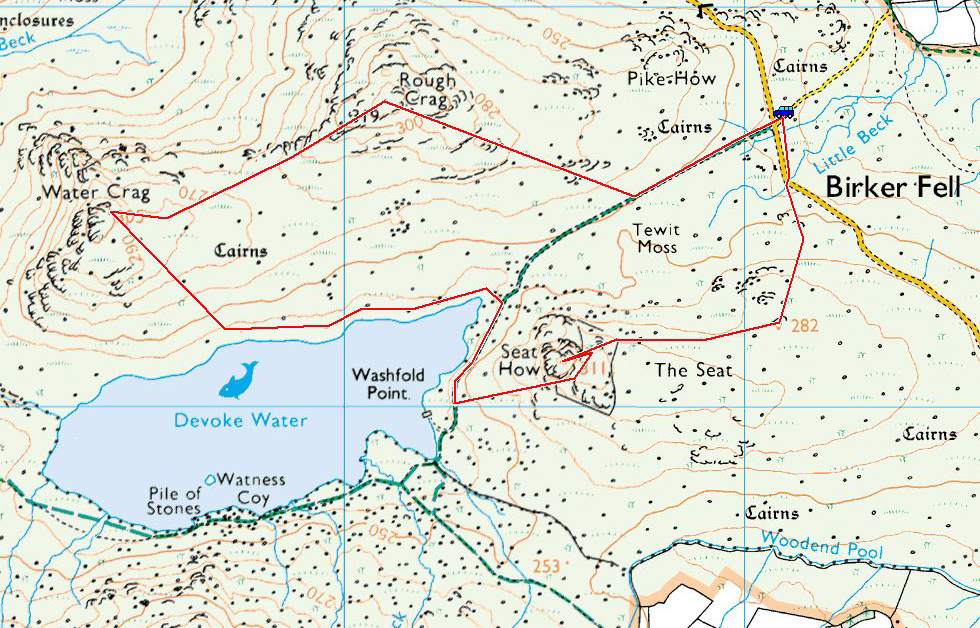
Devoke Water route map.

Harter Fell and Green Crag from Rough Crag.

On Water Crag.

Seat How behind the Old Boathouse.

Another view of the Old Boathouse with Rough Crag behind.

The view to the north-east, the haze beginning to clear now.

Devoke Water.
Start point: Birker Fell road (SD 171 977)
Birker Fell Road – Rough Crag (Birker Moor) (OF) – Water Crag (OF) – White Pike on Birkby Fell (OF) – Yoadcastle (OF)– Woodend Height (OF) – Seat How (Birker Moor) (OF) – Birker Fell Road
Distance: 5.4 miles Total Ascent: 686 metres Time Taken: 2 hours
Weather: Freezing temperatures, clear sunny spells and snow showers.
Devoke Water lies between Eskdale and the Duddon Valley and is hidden just off the Birker Fell road. The Circuit of Devoke Water gives fine views of the fells at the head of Wasdale, Eskdale and out to the Irish Sea. There was a cold, cold wind blowing from the high fells today bringing with it snow flurries, but when the clouds cleared there were some great views.
This round is described in Wainwright’s The Circuit of Devoke Water chapter in his book ‘The Outlying Fells of Lakeland’, page 144.


Elevation profile of the route.

3D image of the walk route.

Scafell and Slight Side from Rough Crag. The flat fell in the centre is Eskdale Fell. The tip of Scafell Pike can just be seen in the cloud to the right of Scafell summit.

Crook Crag and Green Crag with Harter Fell behind from the summit of Rough Crag.

Sellafield over Muncaster Fell and the west coast of Cumbria from Water Crag.

Linbeck Gill.

The Ravenglass Estuary from White Pike. Muncaster Castle is visible in the centre.

Whitfell and Stainton Pike from Yoadcastle.

Harter Fell over a frozen tarn between Yoadcastle and Woodend Height.

Looking north to the Pillar group of fells from Woodend Height. See below for an annotated version of this photo.


The summit of Woodend Height looking over Devoke Water to the high Western Fells.

Devoke Water.

The clouds cleared over Esk Pike and Bow Fell towards the end of the walk. See below for an annotated version of this photo.

Start point: Hole House (SD 181 930)
Hole House – The Pike (9) – Hesk Fell (10) – Seat How (Birker Moor) (11) – Rough Crag (Birker Moor) (12) – Water Crag (13) – The Knott on Stainton Fell (14) – White Pike on Birkby Fell (15) – Woodend Height (16) – Yoadcastle (17) – Stainton Pike (18) – Whitfell (19) – Burn Moor (20) – Kinmont Buck Barrow (21) – Great Paddy Crag (22) – Buck Barrow (23) – Plough Fell (24) – Bigert (25) – Hole House
Weather: Dull and overcast with hill fog and sunny spells.


The Pike...

and Hesk Fell summit.

'The detour to The Pike' - AW 'The Outlying Fells of Lakeland' page 141.

Whin Rigg, Illgill Head and The Scafell range from Seat How.

Devoke Water from Seat How.

The summits of Rough Crag....

and Water Crag - AW 'The Outlying Fells of Lakeland' page 146.

Two views of Linbeck Gill, Devoke Water outfall..

Seat How behind and Caw in the distance.

Stainton Pike from The Knott - 'Seen from The Knott, Stainton Pike assumes the pyramidal shape of Bowfell..'. AW

The impressive cairn on White Pike

Stainton Pike summit.

The summit of Woodend Height

Yoadcastle.

Holehouse Tarn.

Stainton Pike, White Pike, Woodend Height and Yoadcastle from the ascent of Whitfell. Holehouse Tarn is in the foreground.

The Duddon Estuary from the summit of Whitfell.

The summit of Burn Moor looking south to Buck Barrow and Kinmont Buck Barrow.

Overlooking the Duddon Estuary from Kinmont Buck Barrow summit

Great Paddy Crag summit.

Kinmont Buck Barrow from Buck Barrow summit

The first time I have ever seen cows on a summit, on Bigert!

The sun shines! The Coniston range from Plough Fell summit - Grey Friar and Swirl How to the left of the dip, then Brim Fell, Dow Crag, Coniston Old Man, Buck Pike and Brown Pike.

Another view from Plough Fell summit, The Scafells to the left, Esk Pike and Bowfell in the centre with the Crinkle Crags and Harter Fell to the right.

The Pike from the descent of Bigert.