Striding Edge

A photo diary of Lake District fell walks

  • Walks
  • Fells
    • Wainwrights
      • Eastern Fells
      • Far Eastern Fells
      • Central Fells
      • Southern Fells
      • Northern Fells
      • North Western Fells
      • Western Fells
      • Outlying Fells
    • Birketts
  • Dogs
  • Love The Lakes
  • Contact

Helvellyn Sunrise

Walked on 17/12/2021

Start point: Wythburn (NY 324 136)

Wythburn – Birk Side – Nethermost Pike – High Crag – Dollywaggon Pike  – Seat Sandal – Wythburn

Distance: 8 miles    Total Ascent: 1042 metres     Time Taken: 5 hours 30 minutes     Start Time: 06:30

Clear                 
Temperature      5 ℃ 
Felt like        5 ℃
Wind Speed       1.3 mi/h
Wind Direction   ENE

Regular followers of this site over the years will know I like a sunrise walk and particularly at this time of year up to Helvellyn. All the conditions looked to be good for a decent sunrise today so I felt compelled to go for it, and I am mighty glad I did as it was absolutely fantastic up there. Previously all my December walks up there have been memorably cold but this time it was not so bad. Of course you never know what the conditions are really going to be like walking up in the dark but the view of the inversion to the east when nearing the top was fabulous and I knew I was in for a treat from that moment.

DSC8820

Pre-sunrise and it is shaping up to be a fantastic day ahead.

DSC8826

Ghostly Striding Edge is completely enveloped in cloud.

DSC8829

I had time for a walk along the summit plateau before the sunrise proper - there were another couple of people there to witness the spectacle as well.

DSC8834

DSC8836

DSC8839

Here we go, the first glimpse of sunrise - it is, of course, relatively late at this time of year at around 08:30.

DSC8842

Catstycam looking solitary.

DSC8850

Well worth the wait...

DSC8853

...and well worth a photo or two.

DSC8863

Helvellyn sunrise.

DSC8865

It is absolutely superb this morning.

DSC8866

The clouds look like you could jump from the edge into them. Perhaps you could swim to Catstycam?

DSC8872

Striding Edge looking fantastic, like some sort of prehistoric beast emerging from the clouds.

DSC8876

No man is an island.

DSC8877

Fletcher leads the way from Helvellyn.

DSC8879

Striding Edge is constantly changing with more - or less - being revealed by the clouds as they ebb and flow.

DSC8884

Acres of fluffy clouds as far as the eye can see to the east.

DSC8885

Looking great from every angle.

DSC8893

Fletcher is oblivious to the magnificence behind him.

DSC8894

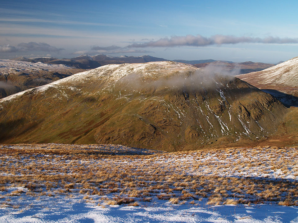
I did hang around on Helvellyn for a good while (for me anyway) and walked along the ridge a couple of time before heading south to Nethermost Pike, here looking to the west with Bowfell to Great Gable in view through the inversion.

DSC8896

The inversion clouds are sinking away from Striding Edge and Catstycam now.

DSC8899

A penny for them Fletcher.

DSC8904

Heading for High Crag.

DSC8908-Pano

A panorama to the west. The central part if the lakes along Thirlmere was clear of cloud.

DSC8922

Fairfield and the Ill Bell ridge beyond.

DSC8926

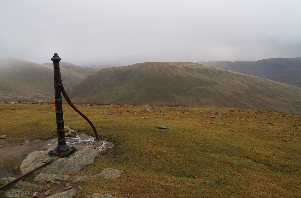
Seat Sandal under a cloud cap. I stopped on Dollywaggon Pike and had a coffee and watched the fascinating cloud movements unfold. The cloud was pouring from Grisedale Tarn and down Raise Beck and began to fill up the Thirlmere valley.

DSC8927

Looking along The Tongue from Dollywaggon Pike summit, a good place to sit for a while. Amazingly I never saw anyone along this ridge after I left Helvellyn.

DSC8928

...and looking back the other way.

DSC8930

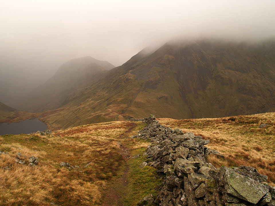
At the old gatepost that marks the start of the steep descent to Grisedale Tarn, Seat Sandal summit is out of the clouds now so let's go for it!

DSC8935

More thoughts for Fletcher on the way down. Oh my, I had forgotten how steep this was!

DSC8937

We're going in!

DSC8940

Then, as if by magic, the cloud has all but gone looking to Fairfield and St Sunday Crag from the steep climb to Seat Sandal.

DSC8941

DSC8944

Grasmere, Windermere and Coniston from Seat Sandal summit.

DSC8945

A brocken spectre? Nearly....sort of...not quite. If the clouds were a bit thicker it would have been a cert from that position but not to worry.

DSC8949

The view from Low Wood on the way home - rarely is Winderemere this calm.

Seat Sandal

Height: 736 metres / 2415 feet Grid reference: NY 34399 11424 Category: The Eastern Fells

Seat Sandal from Great Rigg

Seat Sandal from Great Rigg

Seat Sandal from the old fence post below Dollywaggon Pike

Seat Sandal from the old fence post below Dollywaggon Pike

St. Sunday Crag and Fairfield from the descent of Seat Sandal

St. Sunday Crag and Fairfield from the descent of Seat Sandal

Grisedale Horseshoe

Walked on 12/10/2010

Start point: Patterdale (NY 394 160)

Patterdale – Hole-in-the-Wall – Striding Edge – Helvellyn – Nethermost Pike – High Crag – Dollywaggon Pike – Seat Sandal – Deepdale Hause – Saint Sunday Crag – Birks – Patterdale

Distance: 11 miles     Total Ascent: 1419 metres    Time Taken: 6 hours     Start Time: 06:45

Weather: Sunny and clear. 13C

I was up early this morning to make the most of the expected good weather to come for the day. I wasn’t disappointed and it turned into a fantastic and memorable day on the fells with incredible clarity and an inversion over the Lake District as well. When I set off from Patterdale this morning (in the dark!), the temperature gauge was showing -1C but once the sun rose it was really warm and I ended up completing the walk in shirt sleeves.

Grisedale

Grisedale route map.

12.10.10-003

It was below freezing when I left Patterdale and pretty chilly climbing to the Hole-in-the-Wall, here looking back towards Patterdale with Ullswater under the early morning mist.

12.10.10-019

It was below freezing when I left Patterdale and pretty chilly climbing to the Hole-in-the-Wall, here looking back towards Patterdale with Ullswater under the early morning mist.

12.10.10-031

Sun rising but not visible here yet. That mist is following me up the valley below.

12.10.10-040

The sun rising over High Street.

12.10.10-042

All a-glow heading for the Hole-in-the-Wall.

12.10.10-048

Beautiful sunrise and the inversion has flooded into Grisedale.

12.10.10-052

Climbing the steep section of the path.

12.10.10-055

Looking to Birkhouse Moor from the Hole. All the low lying ground to the east is covered with mist.

12.10.10-061

Helvellyn and Catstycam at dawn.

12.10.10-066_stitch

A panoramic view.

12.10.10-073

Looking back from the climb to High Spying How.

12.10.10-082

Even the normally dull as ditchwater Great Mell Fell looks good today, taking on a special interest in the inversion.

12.10.10-084

The Mell Fells and Gowbarrow Fell rise from the mist, Sheffield Pike in the foreground.

12.10.10-087

The mighty Striding Edge.

12.10.10-091

Flat calm Red Tarn.

12.10.10-096

The view from High Spying How.

12.10.10-103

Crossing The Edge.

12.10.10-116

Red Tarn and Catstycam.

12.10.10-121s

Panoramic Red Tarn.

12.10.10-136

Looking down on Striding Edge.

12.10.10-142

There is a big inversion to the south too looking over the cross shelter. In fact the whole Lake District is surrounded by the inversion.

12.10.10-147

The view from the summit of Helvellyn.

12.10.10-157

Dougal and Casper on the summit.

12.10.10-166

The 'Isle of Skiddaw', the Vale of Keswick is beneath the cloud somewhere.

12.10.10-168s

A panoramic view of the Vale of Keswick.

12.10.10-174

Swirral Edge and Catstycam, the Pennines beyond Ullswater.

12.10.10-178

Cross Fell beyond Ullswater.

12.10.10-184

Looking into the bright sunshine from Helvellyn.

12.10.10-192

Looking to the south west from the path to Nethermost Pike. That distant fell (Black Combe), in solitary peeping out in the clouds intrigued me - I wonder what it would be like to be stood on the top of it? Actually, I have had a similar experience on Hard Knott with Connie (here) and you never know whether you will actually ever get above the cloud.

12.10.10-197

All clear over Bowfell, Scafell and Great Gable.

12.10.10-201

Striding Edge.

12.10.10-203

Misty Grisedale.

12.10.10-215

The view from Nethermost Pike.

12.10.10-220

Casper takes it easy heading for Dollywaggon Pike.

12.10.10-224

The Solway Firth is also under inversion between Robinson and Grasmoor to the north.

12.10.10-232

Dollywaggon Pike from the steep climb to Seat Sandal.

12.10.10-233

Thirlmere under cloud and Skiddaw from Seat Sandal.

12.10.10-234

The Vale of Grasmere.

12.10.10-236

Thirlmere

12.10.10-248

Saint Sunday Crag and Fairfield from the descent of Seat Sandal.

12.10.10-253

Seat Sandal from the start of the climb to Fairfield.

12.10.10-255

I took the path to Deepdale Hause which turned out to be a good one to get to Saint Sunday, well worth a go. It was cold along here though in the shade looking down on Grisedale Tarn.

12.10.10-260

Seat Sandal and Grisedale Tarn.

12.10.10-265

Fairfield and Cofa Pike from Deepdale Hause.

12.10.10-268

Dollywaggon Pike across Grisedale.

12.10.10-274

Looking west from the climb to Saint Sunday Crag.

12.10.10-276

The Helvellyn ridge.

12.10.10-280

The summit of Saint Sunday Crag.

12.10.10-283

Heading for Birks below, Place Fell beyond.

12.10.10-288

Dougal and Casper on Birks.

12.10.10-289

Looking back to Saint Sunday from Birks.

12.10.10-303

On the edge of heaven?

12.10.10-309

Ullswater panoramic.

12.10.10-314

Place Fell.

Striding Edge

Walked on 03/12/2007

Start point: Patterdale (NY 394 160)

Patterdale – Hole-in-the-Wall – Striding Edge – Helvellyn – Nethermost Pike – High Crag –Dol lywaggon Pike – Seat Sandal – Grisedale Tarn – Patterdale

Distance: 11 miles     Total Ascent: 1170 metres     Time Taken: 5 hours

Weather: All sorts, with snow on the tops. 6oC.

It was a bit wintry to say the least today. The climb up to and across Striding Edge was quite clear but with plenty of soft, fresh snow around. As soon as I hit the top of Helvellyn, the clouds came down and made the views non-existent. From then on, there was all sorts of weather – rain, sleet, snow, hail – you name it! Still, it was nice to get in the snow again. It certainly makes a change from the somewhat damper weather we have had recently.

Striding-Edge

03.12.07-006

Grisedale from Grisedale Beck. Looks like there is a bit of snow on Dollywagon Pike and Nethermost Pike.

03.12.07-011

Looking along Grisedale near the start of the climb, St. Sunday Crag up to the left.

03.12.07-014

The view from further up the path.

03.12.07-015

Looking back along the valley to Place Fell.

03.12.07-024

The climb to the Hole-in-the-Wall.

03.12.07-028

Birkhouse Moor from the Hole-in-the-Wall.

03.12.07-036

Catstycam and White Side from the start of the climb towards Striding Edge.

03.12.07-040

Are you ready for this climb?

03.12.07-042

Heading for Striding Edge and Helvellyn.

03.12.07-045

The retrospective view along Low Spying How to Birkhouse Moor and Ullswater. Place Fell seems to be getting a bit of sunshine.

03.12.07-048

Striding Edge and Helvellyn from High Spying How.

03.12.07-051

Red Tarn and Catstycam from Striding Edge.

03.12.07-052

Crossing Striding Edge.

03.12.07-058

Casper getting set for the crossing. There was a strong wind building across the Edge now.

03.12.07-064

From further along.

03.12.07-068

Casper leads the way across the sharp arête.

03.12.07-072

Looking back along Striding Edge.

03.12.07-077

The final part of the climb to Helvellyn - plenty of snow up there.

03.12.07-080

Sunburst over Fairfield.

03.12.07-083

Striding Edge from the climb to Helvellyn.

03.12.07-087

03.12.07-091

Casper - he's doing well the lad!

03.12.07-096

03.12.07-100

03.12.07-103

The Gough Memorial on Helvellyn, erected 1890.

03.12.07-107

Where did all this snow come from?

03.12.07-110

In the cloud on a white Helvellyn summit.

03.12.07-115

Frozen Helvellyn.

03.12.07-124

Out of the cloud descending from Helvellyn towards Nethermost Pike.

03.12.07-128

Striding Edge from Nethermost Pike.

03.12.07-136

A bleak looking Nethermost Pike summit.

03.12.07-138

Grisedale from Dollywagon Pike.

03.12.07-142

Seat Sandal from the old fence post below Dollywaggon Pike.

03.12.07-144

The steep descent down to Grisedale tarn and then straight up the other side for a similarly steep climb to Seat Sandal.

03.12.07-146

Fairfield and Great Rigg across Grisedale Tarn.

03.12.07-148

That was about it with clear weather, it was changing almost by the minute now. This is St. Sunday Crag and Fairfield from the descent of Seat Sandal with sleet and hail moving in.

03.12.07-167

A brief clearing of the weather for a view along Grisedale heading down to Patterdale. A couple of minutes earlier - and later - there were no views.

03.12.07-172

Falls in Ruthwaite Cove.

03.12.07-177

Plenty of water around today.

03.12.07-182

he head of Grisedale from the valley.

Pinnacle Ridge

Walked on 22/06/2004

Start point: Patterdale (NY 390 160)

Patterdale – Pinnacle Ridge – Gavel Pike (72) – Saint Sunday Crag (73) – Cofa Pike (74) – Fairfield (75) – Seat Sandal (76) – Grisedale Tarn – Patterdale

Weather: Sunny and warm.

Another fine and warm day today for a climb up to Saint Sunday Crag using a new route (for me) to the summit, Pinnacle Ridge, a serious and quite challenging technical grade 3 scramble.

The route begins following the Grisedale Valley path until the far edge of Elmhow Plantation is reached.

Pinnacle-Ridge

22nd June - Pinnacle Ridge 001

Nethermost Pike, Dollywagon Pike and Helvellyn from the entrance to the Grisedale Valley. Following the zigzag path up the slopes of St. Sunday Crag from Elmhow Plantation, a grassy terrace is reached. From here it is a right turn to traverse across the horizontal terrace. On reaching a scree fan, Pinnacle Ridge can be seen above with a large, smooth prominent slab clearly visible. This is known as 'The Cannon'.

22nd June - Pinnacle Ridge 005

Ullswater from the horizontal terrace.

22nd June - Pinnacle Ridge 006

Climbing 'The Cannon'...

22nd June - Pinnacle Ridge 008

and the view from the top of The Cannon.

22nd June - Pinnacle Ridge 013

Onwards and upwards from the Cannon

22nd June - Pinnacle Ridge 011

...and again - don't slip! Past The Cannon, the ridge continues over further prominent pinnacles until a difficult rock pitch is reached.

22nd June - Pinnacle Ridge 019

Climbing the difficult rock pitch. Once this is climbed, its virtually home and dry to reach the lower slopes of Saint Sunday Crag. This is truly an exhilarating way to reach the summit.

22nd June - Pinnacle Ridge 022

22nd June - Pinnacle Ridge 028

Looking down Pinnacle Ridge to the Grisedale Valley below. Once onto St Sunday ridge, it is eastwards first to the 'thumb' of Gavel Pike offering a great view of Ullswater.

22nd June - Pinnacle Ridge 029

Ullswater from Gavel Pike. Then an easy ascent to the summit of Saint Sunday Crag itself.

22nd June - Pinnacle Ridge 034

Crinkle Crags and Bowfell from the slopes of Saint Sunday Crag.

22nd June - Pinnacle Ridge 037

Fairfield from Saint Sunday Crag summit. A descent to Deepdale Hause then another ascent to Cofa Pike before the final rocky ascent to Fairfield - a flat, bouldery plateau.

22nd June - Pinnacle Ridge 041

Seat Sandal and Grisedale Tarn from the descent to Deepdale Hause.

22nd June - Pinnacle Ridge 043

Looking back to Saint Sunday Crag and Gavel Pike from Cofa Pike summit.

22nd June - Pinnacle Ridge 052

Bowfell, The Scafell range and Great Gable from the bouldery summit of Fairfield. From Fairfield it's a steep descent westwards and then a very steep ascent to the summit of Seat Sandal which offers good views over Grasmere.

22nd June - Pinnacle Ridge 053

Seat Sandal summit. From Seat Sandal, a steep descent to Grisedale Tarn and follow the Grisedale Valley path back to Patterdale.

22nd June - Pinnacle Ridge 059

Saint Sunday Crag from Grisedale Valley. Pinnacle Ridge is up there somewhere.

Helvellyn

Walked on 07/11/2003

Patterdale – Birkhouse Moor (140) – Striding Edge – Helvellyn – Nethermost Pike (141) – Dollywaggon Pike (142) – Seat Sandal (143) Fairfield – Cofa Pike – Saint Sunday Crag – Birks – Patterdale

013.JPG
014.JPG
015.JPG
016.jpg
017.JPG
018.JPG
019.JPG
020.JPG
021.jpg
022.JPG
023.jpg
024.JPG
025.JPG
026.JPG
027.JPG

Walking Diary

  • The Mosedale Horseshoe 01/03/2022
  • Caw 18/01/2022
  • Coniston sunset 17/01/2022
  • Blencathra 15/01/2022
  • Scafell Pike 14/01/2022

Social

  • Facebook
  • Twitter

Information

  • Striding Edge
  • T&C’s
  • Privacy
  • Links