Height: 508 metres / 1667 feet Grid reference: NY 31189 12531
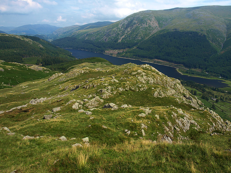
Thirlmere from Wythburn Fell
Height: 508 metres / 1667 feet Grid reference: NY 31189 12531
Thirlmere from Wythburn Fell
Start point: Dobgill (NY 316 140)
Dobgill – Harrop Tarn – Wythburn Fells – Wythburn Fell – Ullscarf – Standing Crag – Harrop Tarn – Dobgill
Distance: 5.5 miles Total Ascent: 573 metres Time Taken: 3 hours
Weather: Sunny and warm, becoming overcast with a stiff breeze on the tops. 23º.
Ullscarf wasn’t really on the agenda today but I ended up there as I wanted a walk that would be quiet and away from the crowds and also somewhere with a stretch of water so that I could have a swim if required on such a hot day. This walk fulfilled both of these requirements and this was a decent walk despite the weather closing in on the latter half.


The waterfall on Dob Gill, reduced to a trickle.

Harrop Tarn and Tarn Crags. The tarn is looking really shrunken after the dry weather, reduced to half its normal size I would say.

Tarn Crags.

Water Lilies.

Climbing to Wythburn Fells, the Beacon directly ahead.

Blencathra, the Dodds, Helvellyn and Thirlmere from the Beacon.

Casper on the Beacon.

Steel Fell across Wythburn.

The Beacon - a short section of dry stone wall - looking towards Thirlmere.

Blencathra and Clough Head from further along the ridge looking across the Beacon.

Steel Fell.

Looking back along the ridge from Wythburn Fell.

Steel Fell with Helm Crag in silhouette.

Heading for the plateau of Ullscarf.

Looking back towards the Helvellyn massif and Fairfield.

Once at the summit of Ullscarf, conditions started to change as the cloud started to gather over the high fells to the west, here looking towards Great Gable.

Casper in the grass on Ullscarf.

Just follow the yellow brick road off Ullscarf.

High Saddle and low Saddle of Coldbarrow Fell from Standing Crag.

The northerly aspect from Standing Crag. The route back to Dobgill is down to the fence below then head to the right half way along, descending to the forest.

Blea Tarn from Standing Crag.

Looking back to Standing Crag. The fence manages to go straight through this small tarn.

The descent to Thirlmere Forest.

Back to Harrop Tarn and the Foxgloves swaying in the now quite strong breeze.

'Are you coming in? The water's lovely.' How could I resist an offer like that? It was absolutely sweltering today, despite the breeze, and Harrop Tarn turned out to be a lovely place to cleanse my soul with a cooling dip in this little piece of heaven.
Start point: Dobgill (NY 316 140)
Dobgill – Harrop Tarn – Wythburn Fells – Wythburn Fell – Ullscarf – Standing Crag – Harrop Tarn – Dobgill
Distance: 6.6 miles Total Ascent: 1087 metres Time Taken: 3 hours 15 minutes
Weather: Rain and hail with some sunny spells. 8oC.
I think we timed it to perfection for this wet walk up to Ullscarf, managing to miss the worst of the weather although we did encounter a particularly vicious hailstorm! All the becks were in spate due to the amount of water that has fallen from the skies and this area remained as boggy as usual. We even managed to see the sun today!


The waterfall on Dob Gill in full force.


Harrop Tarn in the rain.

The Wythburn Fells ridge with the Beacon on the first rise to the left.

Steel End and Steel Fell with Seat Sandal beyond.

The Helvellyn ridge across Thirlmere from the Beacon.

A heavy hailstorm after it passed over us (ouch!) with the sun closely following behind it.

Casper on Wythburn Fell.

Looking towards Ullscarf - blue sky!

Dollywagon Pike and Seat Sandal beyond Steel Fell.

Wythburn Fell catches the sunshine.

Wyth Burn below in spate looking to Calf Crag beyond.

Fairfield has come out of the clouds beyond Seat Sandal now.

So has the Helvellyn range on the climb to Ullscarf.

The Helvellyn ridge.

Steel Fell and Helm Crag with Grasmere visible.

Heading for Ullscarf.

Helvellyn.

Seat Sandal and Fairfield.

All clear...for now, that is.

A wet and windy Ullscarf.

Derwent Water and Bassenthwaite Lake with a clear view of Skiddaw from the Ullscarf ridge.

Descending back to Thirlmere Forest.

Mosshause Gill.

Back to Harrop Tarn.
Start point: Dobgill (NY 316 140)
Dobgill – Brown Rigg (285) – Blea Tarn Fell (286) – Standing Crag (287) – High Saddle of Coldbarrow Fell (288) – Low Saddle of Coldbarrow Fell (289) – Ullscarf (290) – Wythburn Fell (291) – Dobgill
Weather: Grey and overcast.
Today’s walk is a round of Ullscarf – a remote and mainly pathless area which is mainly grassland. The weather was brighter than could have been expected with the sun making the odd appearance and no rain; cloud was prevalent above 500m.


Elevation profile of the route. Key: BR=Brown Rigg, BTF=Blea Tarn Fell, SC=Standing Crag, HS=High Saddle, LS=Low Saddle, U=Ullscarf, WF=Wythburn Fell

3D image of the walk route.

From times past...an ancient walled lane leading from nowhere to nowhere, presumably in use prior to the creation of Thirlmere.

The head of Thirlmere.

The distinctive balancing stone which marks the summit of Brown Rigg.

High Tove from Blea Tarn Fell (un-named on the O.S map).

Blea Tarn. Misty summits...

Standing Crag.

High Saddle of Coldbarrow Fell.

Low Saddle of Coldbarrow Fell.

Ullscarf.

Thirlmere from Wythburn Fell.

Seat Sandal from 'Beacon', marked on the O.S map.

Harrop Tarn.

Waterfall on Dob Gill.