Height: 298 metres / 978 feet Grid reference: SD 26083 85869 Category: The Outlying Fells
The Coniston fells from Burney, named Great Burney on the OS map
Height: 298 metres / 978 feet Grid reference: SD 26083 85869 Category: The Outlying Fells
The Coniston fells from Burney, named Great Burney on the OS map
Start point: Woodland Fell road (SD 258 852)
Burney (OF) from the Woodland Fell Road
Distance: 1.2 miles Total Ascent: 122 metres Time Taken: 30 minutes Start Time: 10:20
Weather: Cats and dogs, 9C
It was absolutely chucking it down today but those dogs still need to be walked whatever the weather, so it was a local short walk up to Wainwright Outlying fell Great Burney. They don’t seem to mind the rain so much and neither do I really but it makes for an interesting ‘quick on the draw’ style of photography! Today, I was mostly wearing Paramo…

At the start of the track on Kirkby Moor and look at those stair rods!

That looks like a hurry up call from Casper as we head towards Combs.

This may look like just a pile of embedded old stones but is the site of an ancient stone circle.

It feels like you are on ancient tracks around here and the area is well known for its bronze age artefacts. This ancient cairn lies on the track to the Crake Valley and Coniston Water is lost in the mist beyond.

Casper and Dougal at the top of Great Burney.

Damp and muddy Casper.

Not much to see from lowly Burney today.

I'm not sure what that look from Casper means - 'it's a bit wet Dad?'
Burney (OF) from the Woodland Fell Road
There was a cool breeze despite the warm sunshine in the southern Lake District this afternoon. Once again it seemed as though our little corner had all the sunshine whilst to the north looked a lot cloudier. Burney lies on the southernmost tip of the Lake District National Park and offers fine views for relatively modest effort.

Tired already Casper? The summit plateau of Great Burney after the steep climb.

Coniston Water from Great Burney, Fairfield and Red Screes beyond.

Soaking up the sun.

Angus and Casper at the summit.

Close-up on Coniston Water.

The Coniston fells beyond Blawith Knott.

The Scafells.

The Duddon Estuary.

All clear over Black Combe.

Kirkby Moor with its prominent windmills from Great Burney.
Burney (OF) from the Woodland Fell Road
Distance: 1.5 miles Total Ascent: 120 metres Time Taken: 1 hour
Weather: Dull. 18oC.
There was no sunshine this morning and the higher fells were enveloped in a thick cloak of cloud so we decided to walk up to Great Burney, a compact Outlying Fell which is on the southern edge of the Lake District National Park. Connie was keen to try out her new boots today – I think they passed with flying colours!


Lowick High Common (Kirkby Moor) from the start of the walk.

From the ancient cairn between Combs and Great Burney there is a glimpse of Coniston Water with Beacon Fell prominent in the centre.

Connie shows off those new boots.

Louise and Connie on the steep climb to Great Burney.

Casper and Angus at the summit.

Outlying Fells Blawith Knott, Tottlebank Height and Beacon Fell across Subberthwaite Common.

The giant windmills on Kirkby Moor from Great Burney.

The bad weather is moving in across the Duddon Estuary now - Black Combe is submerged under the cloud here and the rain was on us within a couple of minutes.
Burney (OF) from the Woodland Fell Road
It was another short but pleasant walk for us in the sunshine this afternoon up to Great Burney; with the temperature reaching the heady heights of 16C, it was too good an opportunity to miss the chance of a bit of fresh air. Shame about the haze again, but I guess you can’t have everything!

Great Burney from Beck Stones.

Great Burney from Kirkby Moor across Moor House.

Casper gets in his trademark (and somewhat early - we're not there yet!) victory roll on the way to Great Burney.

It was very hazy today, not so good for views but very pleasant although there was a stiff breeze on the top of Great Burney, here looking to the Coniston fells with the familiar outline of Dow Crag and The Old Man.

Looking to the Dunnerdale Fells, Stickle Pike in the centre.

Angus and Casper enjoying the sunshine...

...but Casper does a good job of showing the breeze whilst wily old Angus finds the best position to keep out of it.

The Coniston fells over Blawith Knott.

The golden sands of the Duddon Estuary.
Start point: Woodland Fell road (SD 259 852)
Burney (OF) from the Woodland Fell Road
Distance: 1.5 miles Total Ascent: 150 metres Time Taken: 1 hour
Weather: Sunny with a stiff breeze. 13oC.
Today was a day of two halves – raining and dreary this morning, clearing in the afternoon to give bright sunshine and blue skies. Great Burney lies on the south western edge of the Lake District National Park and is easily reached from the main A5092 road for an easy ascent with lovely views.


Great Burney from the Woodland Fell road. The route of ascent is along the wall to the right and the route of descent is the track heading diagonally left.

The Coniston fells from the cairn between Great Burney and Coombs.

Great Burney summit looking to Caw and Coniston.

The Duddon Estuary over the green fields.

There was a cool, stiff breeze on the top - it looks as if Angus' lead has skewered Casper here!

Casper.

The Coniston fells.

Stickle Pike and Caw.

Windmills on Kirkby Moor to the south.

Looking over Burney Tarn and the Duddon Estuary to Black Combe.
Start point: Corney Fell road (SD 150 896)
Corney Fell road – Stoneside Hill (251) – Great Paddy Crag – Buck Barrow – Kinmont Buck Barrow – Corney Fell road and then Burney (OF)
Weather: Overcast, cold.
Today’s walk was a short one from the Corney Fell road – no views whatsoever from any of the peaks visited, in complete contrast to the weather round here yesterday.


Stoneside Hill from the Corney Fell road.

Looking towards the west Cumbrian coast from Stoneside Hill summit.

Which way down from Buck Barrow? On the way home, I could see the clouds hanging in the Crake valley - it was worth a short ascent to Wainwright Outlying fell Burney for a better view.

Beacon Fell to the left and the clouds forming in the Crake Valley.

The southern end of the Crake Valley.

The Duddon Estuary.

Windmills on Kirkby Moor from Great Burney.


(i) Start point: Woodland Fell road (SD 256 879)
Woodland Fell Road – Blawith Knott (OF) – Lang Tarn – Tottlebank Height (OF) – Woodland Fell Road
(ii) Start point: Woodland Fell road (SD 259 852)
Burney (OF) from the Woodland Fell Road
Route Map
Weather: Sunny with a stiff breeze.
Two more short walks this morning to keep away from the crowds and the threatened bad weather. As it turned out, the weather wasn’t too bad with sunny intervals. The walks followed were the Blawith Knott and Burney chapters in Wainwright’s ‘The Outlying Fells of Lakeland’.


Blawith Knott from the Woodland Fell road.

Giant's Grave, believed to be a Bronze Age barrow. This is right by the roadside at the start of the walk so you can't miss it. It looks like a headstone with a circle of stones on its southern side (nearest the camera in the photo).

The Coniston Fells from the summit of Blawith Knott.

Two more views from Blawith Knott; Black Combe behind...

and Stickle Pike, the Dunnerdale Fells and Caw.

Lang Tarn shares with Foxes Tarn on Scafell the distinction of being the smallest named tarn in Lakeland. This took some finding, a lot of wet areas seem to be dried up around here.

Wetherlam on the left with Dunmail Raise and Kirkstone pass visible from the summit cairn of Tottlebank Height. Coniston Water can just be seen right of centre. A short drive up the Woodland Fell road for another quick walk with a circular route of Burney.

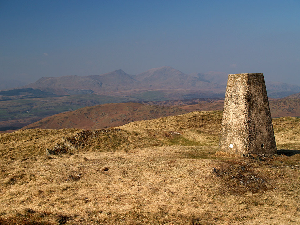
This area is rich in prehistoric remains, including Bronze Age field systems and a mediaeval homestead. This is a view of Burney across the remains of a stone circle with the centre standing stone clearly visible.

The views from Burney are excellent for a fell of such small stature. This is a view of Coniston Water and the distant Helvellyn and Red Screes from the summit.

The Duddon Estuary from Burney.