Height: 512 metres / 1680 feet Grid reference: NY 39241 12426
Place Fell from Gale Crag summit
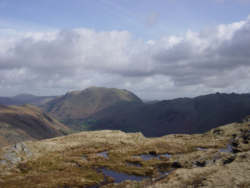
Height: 512 metres / 1680 feet Grid reference: NY 39241 12426
Place Fell from Gale Crag summit
Start point: Cow Bridge, Hartsop (NY 403 134)
Cow Bridge – Brothers Water – Priest’s Hole cave – Hartsop Above How – Gale Crag – Deepdale Bridge
Distance: 5.4 miles Total Ascent: 633 metres Time Taken: 2 hours 40 minutes Start Time: 09:20
Weather: Sunny and clear. 8oC
There was different weather once more today, it was really clear with bright sunshine with just a sprinkling on snow on the tops. The sun quickly warmed it up and it was shirt sleeves all the way for this one.


Brothers Water reflections.

It was absolutely glorious this morning.

There was a mirror finish on the water.

Swanny comes to visit...or to chase Dougal and Casper away.

Brock Crags.

It was looking very Wasdale-like here today.


Angletarn Pikes. On with the walk - firstly I had to get past the herd of cows, complete with youngsters, at Hartsop Hall farm. This was no mean feat to accomplish with the two 'cow magnets' in tow without getting trampled to death. It certainly made things a little 'interesting' and we had to find a way to sneak round their blind side.

Dove Crag from Dovedale.

Looking to Hogget Gill and Little Hart Crag.

The path to Dove Crag.

Surveying the climb.

A fabulous view looking back from the climb, it was really warm in the sunshine as well.

Hartsop above How from Hunsett Cove.

Phew, made it. At the top of the climb. I took a slight detour from the path to seek out the Priest's Hole, a small cave high up on Dove Crags.

The view from the ledge outside the Priest's Hole - straight down from here.

The Priest's Hole.

A window on the world from inside the cave. The path to the cave is difficult to see and I directed two others to it as I descended to cross over to the Hartsop above How ridge.

On Black Crag, part of the Hartsop above How ridge with a great view of High Street and the far eastern fells.

Hart Crag.

Dougal and Casper on Hartsop above How, enjoying the glorious weather.

Hart Crag and Fairfield from the summit of Hartsop above How

Deepdale and Fairfield with Dollywaggon Pike on the far right.

Place Fell and Patterdale on the descent of the ridge.

Angletarn Pikes and Brock Crags. We will cross the stile at the bottom of the photo to head back down to Cow Bridge.

Above Brothers Water.
Start point: Deepdale Bridge (NY 399 144)
Deepdale Bridge – Gale Crag – Hartsop Above How – Hart Crag – Fairfield – Cofa Pike – Saint Sunday Crag – Gavel Pike – Birks – Arnison Crag – Deepdale Bridge
Distance: 10.3 miles Total Ascent: 1431 metres Time Taken: 4 hours 45 minutes
Weather: Clear and cold, especially on the highest tops. 9oC.
After a cold and frosty night, it was a really clear day today with lovely blue skies and autumnal colours all around Deepdale. The Hartsop above How ridge is a fine walk and the return across Fairfield and St. Sunday Crag makes a lovely circuit of the valley. Angus and Casper managed to get recognised again on St. Sunday Crag by a StridingEdge fan, and (by default) so did I!


Autumnal Deepdale at the start of the walk.

Gavel Pike on St. Sunday Crag from the Hartsop above How ridge.

St. Sunday Crag across Deepdale.

Looking back to Place Fell.

Angletarn Pikes.

St. Sunday Crag.

Onward and upward - looking back to Place Fell and Angletarn Pikes.

Looking along the ridge to Hart Crag and Fairfield.

Angus.

A pair of Beardies on Hartsop above How. Down below in Dovedale, I could see foxhounds and hear the constant shouts and blowing horn of the huntsmen. Not sure what they hunt these days, though!

Looking across an icy pool to Hart Crag and Fairfield.

Fairfield.

Looking down the Hartsop above How ridge from Hart Crag.

Shooting into direct sunlight, not a good idea - but I liked the way the sun lit up Windermere and Morecambe Bay from Hart Crag.

The summit of Hart Crag.

The western fells from Fairfield, the familiar shape of Great Gable to the left.

...and a wider panorama.

Great Gable.

Looks busy over on Helvellyn.

Dollywagon Pike, Nethermost Pike and Helvellyn across Grisedale.

Cofa Pike and St. Sunday Crag.

Seat Sandal above Grisedale Tarn and the view westwards beyond from Cofa Pike.

Dollywagon Pike.

The summit of St. Sunday Crag - it's starting to cloud a bit now.

Gavel Pike and the Far Eastern fells from St. Sunday Crag. I could hear the bellowing of stags somewhere down below from here.

Ullswater and Birks from Gavel Pike.

Birks.

Hartsop on the descent from Birks.

Ullswater and Great Mell Fell from Trough Head.

Hartsop from the summit of Arnison Crag.

Just the three of us here on Arnison Crag.

Place Fell and Autumn in Deepdale.
Start point: Cow Bridge, Hartsop (NY 403 134)
Cow Bridge – Gale Crag (322) – Hartsop Above How (323) – Hart Crag – Fairfield – Cofa Pike – Saint Sunday Crag –Gavel Pike – Birks (324) – Arnison Crag (325) – Cow Bridge
Distance: 9.7 miles Total Ascent: 1385 metres Time Taken: 4 hours
Weather: Sunny with a strong breeze. 8oC in the valley rising to 12oC. Icy cold on the tops.
I had a great high level ridge walk today along the Hartsop above How ridge, up to Hart Crag and Fairfield and then back down along the Saint Sunday ridge. It was a pleasant surprise to see the sunshine, but it was deceptively cold on the tops with a bitter wind blowing. With hindsight I would have been better off starting and finishing at Deepdale Bridge and walking the full Hartsop above How ridge.

Fairfield route map.

Elevation profile of the route.

3D image of the walk route.

Caudale Moor, Kirkstone Pass and Red Screes in early sunlight from the steep ascent to the Hartsop Above How ridge.

Hartsop Dodd over Brothers Water. To the left are Gray Crag and High Street.

Place Fell from Gale Crag summit. Great Mell Fell can be seen to the left.

The view along the ridge from the summit of Hartsop above How.

Dove Crag.

Looking back along Hartsop above How from Hart Crag.

The view from Rydal Head. Windermere, Esthwaite Water and Coniston Water are all visible.

Fairfield summit.

Cofa Pike to the left and Saint Sunday Crag.

Grisedale Tarn and the Dollywagon Pike - Nethermost Pike - Helvellyn ridge.

Striding Edge and Helvellyn from Saint Sunday Crag. The peak of Catstycam is to the right, then Raise and the Dodd's.

Gavel Pike and Saint Sunday Crag from Birks.

Ullswater from Arnison Crag.

Arnison Crag.