Height: 733 metres / 2405 feet Grid reference: NY 14027 10985
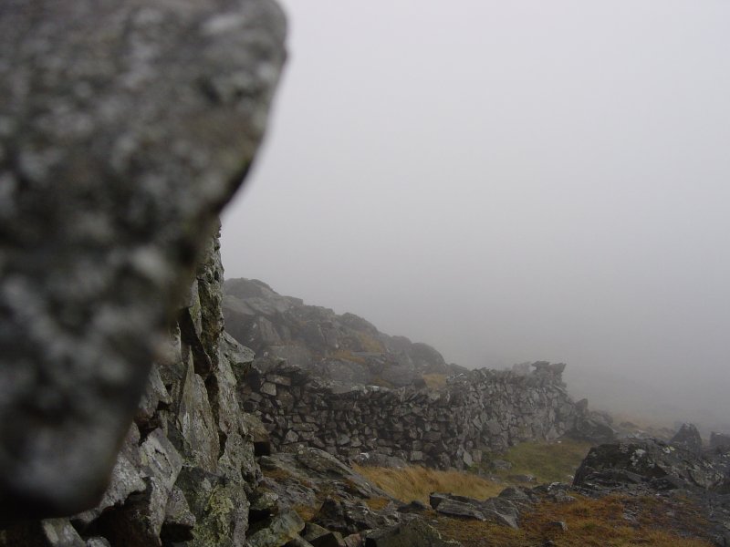
The Ennerdale Fence runs right over the summit of Little Gowder Crag.
Heading for Little Gowder Crag
Height: 733 metres / 2405 feet Grid reference: NY 14027 10985
The Ennerdale Fence runs right over the summit of Little Gowder Crag.
Heading for Little Gowder Crag
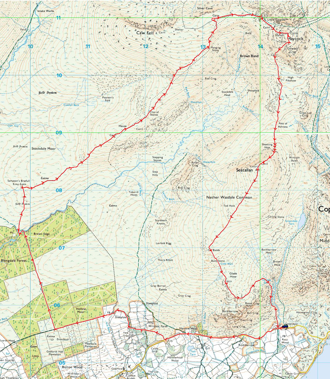
Start Point: Greendale (NY 144 056)
Greendale – Blengdale Forest – Sampson’s Bratfull – Stockdale Moor – Caw Fell – Little Gowder Crag – Haycock – Pots of Ashness – Seatallan – Cat Bields – Glade How – Buckbarrow – Greendale
Distance: 13 miles Total Ascent: 1067 metres Time Taken: 6 hours 30 minutes Start Time: 09:30
Weather: Sunny spells, 8°C
I knew this would be a long one today so hopefully I would time it right to use the daylight to best advantage. The going over Stockdale Moor is a bit of a trudge to say the least and it seems to go on forever – the highlight was coming over Seatallan to the sunset, it was just fantastic. This route will feature in a future edition of Trail magazine.

A bit overcast but still gorgeous in Wasdale

Ancient walled track above Windsor Farm

There was an interesting crossing of the River Bleng as the stepping stones at Sergeant Ford are long gone and it appears there is no way across without getting your feet wet. I used the downstream side of the water gate downstream of this crossing, it worked a treat.

Blengdale with Haycock's top in cloud and Seatallan to the right

Sampson's Bratfull gains an addition. Stones dropped from the apron of a giant as he strode across the moor so legend has it - I bet he got his feet wet!

There are lots of antiquities and old cairns on Stockdale Moor. It is tough going along here with the tussocky and boggy grass, it gave the curse-o-meter an airing anyway - did you hear me?

Seatallan

Little Gowder Crag and Haycock

Which way Dougal?

The Scafells finally out of the cloud

Hanging Stone (also gaining an addition!)

Aeroplane wreckage on Caw Fell

Caw Fell. It certainly looks a lot brighter to the north, looking across to the High Stile ridge.

Heading for Little Gowder Crag

Ennerdale

Hair raising for the boy

My best pal waiting patiently, taking it all in

Caw Fell

Caw Fell and Little Gowder Crag from the climb to Haycock

Steeple and Scoat Fell from Haycock

Seatallan and Blengdale

Blengdale

Haycock from Pots of Ashness

...and from the climb to Seatallan

Yewbarrow lit up by the sunshine. Such are the short days at this time of year I could feel the sun setting as I climbed Seatallan as the skies were reddening, the shadows growing longer and the temperature noticeably dropping.

Stockdale Head

A wider view

Great Gable

Great Gable and the Scafells lit by the setting sun

Close up on the Scafells

What a handsome chappie

Seatallan

Seatallan sunset

You may well gaze in wonderment Dougal my lad!

Cat Bields - as the sun went behind the cloud it was like the lights had been dimmed considerably, so it was a case of getting down before darkness finally fell

The Screes
Start point: Bleach Green, Ennerdale (NY 085 153)
Bleach Green – Bowness – Great Borne – Starling Dodd – Little Dodd (Ennerdale) – Red Pike (Buttermere) – High Stile – High Crag – Memorial Bridge, Ennerdale – High Level Traverse – Shamrock Traverse – Pillar – Black Crag (Pillar) – Scoat Fell – Steeple – Haycock – Little Gowder Crag – Caw Fell – Ennerdale Fell – Crag Fell – Bleach Green
Distance: 18 miles Total Ascent: 2183 metres Time Taken: 10 hours Start Time: 06:00
Weather: Sunny and warm. 15°C
It’s a good while since I have done a full day walk and today seemed like a good opportunity to do a circuit of lovely Ennerdale. The weather was superb, a bit fresher than of late and the air was clearer for it. It was a great day out amongst my favourite fells and it was relatively quiet up there too, although it was good to chat to StridingEdge fans on Scoat Fell and then on Steeple.

Ennerdale circuit route map.

Early morning in Ennerdale.

Pillar silhouetted at the head of the Water.

Crag Fell.

Looking out from the shadows on the steep climb to Great Borne.

Suddenly, out of the shadows and into the sunlight and heading for the summit of Great Borne.

Gavel Fell from Great Borne.

Ennerdale. The outward leg of today's walk is to the left, the return is to the right.

The Loweswater fells - Gavel Fell, Hen Comb and Mellbreak.

Grasmoor across Crummock Water.

Any old iron? Starling Dodd summit.

Layers of fells.

Early morning shadow on Little Dodd.

Starling Dodd and Great Borne from the climb to Red Pike.

The summit of Red Pike.

A panoramic view from Red Pike, Loweswater and Crummock Water in view.

Casper and Dougal, hot already.

Bleaberry Tarn and beyond on the way to High Stile.

High Stile summit.

Ennerdale Water.

A great panoramic view from High Stile - Red Pike and Dodd to the left, Crummock Water and Grasmoor to the right.

A clear view across to the Scafells, Great Gable and Kirk Fell...and of course the mighty Pillar.

A panoramic across Ennerdale.

Robinson across Buttermere.

Pillar looks so tempting from here.

Grasmoor and the Coledale fells across Buttermere.

High Stile from the summit of High Crag.

A view through to Skiddaw and Blencathra from High Crag.

Instead of descending Gamlin End, I decided to go for a route 1 steeper than steep descent to Ennerdale direct (for masochists only this one, a real leg trembler!). I can see the Memorial Bridge from here (to the left of the tree line) where I want to cross and then the route of ascent is up and above the rocky knoll then to the right following the line of the beck before cutting diagonally left beneath Pillar Rock.

Dougal tries to stop himself sliding all the way down into Ennerdale.

You see yon precipice--it almost looks Like some vast building made of many crags, And in the midst is one particular rock That rises like a column from the vale, Whence by our Shepherds it is call'd, the Pillar. Extract from 'The Brothers', William Wordsworth 1800

Down at the Memorial Bridge.

Crossing the River Liza - Casper is easy to spot but can you see Dougal?

Time for lunch (even though it is only 10.30!) and a seat with a fantastic view of Pillar Rock towering above. Now all I have to do is climb up there. To be continued...after my lunch...

Looking back across to High Crag from the climb to Pillar. The route I used in descent is the diagonal scree run to the right.

Ennerdale and the fells just walked.

Into the lost valley. Pillar Rock naturally dominates the scene on this section of the walk.

Magnificent Pillar Rock.

Haystacks with Robinson's Cairn bottom right.

Rounding the base of it to join the High Level Traverse.

High Stile panoramic.

Phew, made it! Dougal gets an eye opener when he spots the Shamrock Traverse.

Pisgah and the east face of High Man. No Slab and Notch route for me today!

It all looks so reachable from the Shamrock Traverse but there is a climb needed from any angle.

Climbing higher with a view over Pillar Rock to High Stile and High Crag and the fells beyond.

The summit of Pillar.

Ennerdale from Pillar.

Time for a second lunch stop on Pillar with a view to Great Gable, the Scafells and Wasdale Head.

Looking back to Pillar from Black Crag.

The east face of Steeple from Black Crag.

Red Pike - the Wasdale one.

Scoat Fell summit and a couple of StridingEdge fans ahead.

Pillar from Scoat Fell.

The route to airy Steeple and Dougal and Casper have spotted yet another StridingEdge fan to greet us.

Pillar and Great Gable from Steeple.

Ennerdale Water.

Looking back on the descent of Scoat Fell - it looks like there is a party on Steeple to the left now.

Heading for Haycock.

Steeple and Scoat Fell from the summit of Haycock.

Dougal checks out the route over Little Gowder Crag to Caw Fell.

Caw Fell.

Haycock from Caw Fell where we met some Beardie fans!

The descent of Caw Fell following the wall to Iron Crag on Ennerdale Fell.

The summit of Ennerdale Fell - Pillar, Steeple, Scoat Fell and Haycock in view.

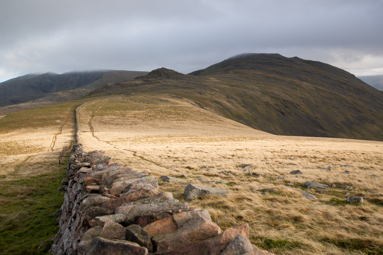
The long walk in following the Ennerdale Fence.

Crag Fell.

An Ennerdale panoramic from Crag Fell.

The field back to the car park was full of cows so I didn't fancy crossing that with the two cow magnets in tow, so was forced to take a detour back down to the lake and passed this summer meadow on the way.
tart point: Greendale (NY 144 056)
Greendale – Blengdale Forest – Sampson’s Bratfull – Stockdale Moor – Caw Fell – Little Gowder Crag – Haycock – Pots of Ashness – Seatallan –Middle Fell – Greendale
Distance: 12 miles Total Ascent: 1150 metres Time Taken: 5 hours 30 minutes
Weather: Clear with a cool breeze. 10°C.
It turned out to be great weather today and it felt very spring like at times, although the wind was cold on the tops. I completed a walk around Blengdale climbing to Caw Fell by the little visited Stockdale Moor, an interesting way to go just to find out exactly what ‘Sampson’s Bratfull’, marked on the map, was! It was very clear today allowing widespread views as far as Scotland and over to the Isle of Man.


Early (ish) morning in Wasdale.

Buckbarrow.

Middle Fell.

Buckbarrow from further along the road.

Here's a view that won't be like this for long looking at the recently planted trees in the foreground; Haycock and Seatallan from Blengdale Forest.

Haycock, Scoat Fell and Seatallan from the Sergeant Ford crossing of the River Bleng.

Seatallan.

Sampson's Bratfull - stones dropped from the apron of a giant as he strode across the moor, so legend has it. It is the site of an ancient barrow, the area being littered with antiquities and signs of ancient settlements. This view is looking to Ponsonby Fell.

Seatallan from Stockdale Moor.

...and again, the Scafells now coming into view.

Angus and Casper take a breather on the summit of Caw Fell with Pillar, Steeple and Scoat Fell to the left of Little Gowder Crag, centre, and Haycock to the right.

Heading for Little Gowder Crag, a really cold wind blowing across here now.

A glimpse of Ennerdale Water and Ennerdale from Haycock, the wall leading from Little Gowder Crag.

Steeple and Scoat Fell from Haycock, Pillar just visible above the wall at the top of Scoat Fell.

Red Pike above Scoat Tarn with the Scafells beyond.

Steeple from Haycock.

Looking across Ennerdale from Haycock to Herdus and the Loweswater Fells, Scottish mountains clearly visible today across the Solway Firth.

Red Pike and Scoat Tarn.

Another breather for these two on Haycock.

Blengdale - the ridge walked so far is to the right from the forest.

The best view is the other way Angus!

The Scafell range from Haycock - Great End with a touch of snow lingering, Broad Crag, Scafell Pike, Scafell and Slight Side.

Haycock across Pots of Ashness at the start of the steep climb to Seatallan.

Great Gable flanked by Kirk Fell and Yewbarrow from Seatallan.

Caw Fell and Haycock above Stockdale Head.

Casper on Seatallan.

The view to the west from Seatallan.

Middle Fell, the next objective, and Greendale Tarn.

Scafell from Middle Fell.

Scafell Pike.

Scafell Pike, Mickledore and Scafell.

Kirk Fell and Great Gable across Yewbarrow.

Angus and Casper on Middle Fell.

Lingmell and the Scafells at the head of Wast Water.

Tired Casper?

A bit blowy again for Angus on Middle Fell, Yewbarrow and Great Gable beyond.

Blue sky over the Scafells from the descent of Middle Fell.

The Screes across Wast Water looking colourful.
Start point: Bleach Green, Ennerdale (NY 085 153)
Bleach Green – Bowness – Brown How (Ennerdale) – Herdus – Great Borne – Gale Fell – Starling Dodd – Little Dodd (Ennerdale) – Red Pike (Buttermere) (357) – High Stile (358) – High Crag (359) – Haystacks (360) – Looking Stead – High Level Traverse – Shamrock Traverse – Pillar – Black Crag (Pillar) – Scoat Fell – Steeple – Haycock – Little Gowder Crag – Caw Fell – Ennerdale Fell – Crag Fell – Bleach Green
Distance: 23.6 miles Total Ascent: 2864 metres Time Taken: 10 hour 20 minutes
Weather: Mainly sunny with lots of snow (!) showers. 7-11°C, valley level – much colder on the tops.
Today’s walk is a long, high level circuit of the beautiful Ennerdale Valley with virtually the whole route being completed at an elevation in excess of 500m. I have had this one on my list of ‘to do’ walks for a while so it was satisfying to complete the walk on a mainly clear day. The photo’s here actually belie the conditions somewhat as the clouds came in when I was crossing from Haystacks to Pillar and there was an icy blizzard. The snow showers continued to come and go throughout the rest of the walk and conditions remained very cold.

Ennerdale Circuit route map.

An early morning silhouette of Ennerdale.

The sunlight on Crag Fell.

A good view from Red Pike of the round completed last Thursday.

Crummock Water from Red Pike.

High Snockrigg and Robinson over Buttermere with Bleaberry Tarn in the foreground.

Looking from High Stile across Bleaberry Tarn and Red Pike to Mellbreak and Crummock Water. Loweswater is visible in the distance.

The sun lights up Pillar Rock across Ennerdale on the north face of Pillar - from High Crag.


Fleetwith Pike and Dale Head from High Crag.

High Crag from Haystacks with Ennerdale to the left and the Buttermere Valley to the right.

Green Gable, Great Gable and Kirk Fell at the head of Ennerdale from Haystacks. The clouds were ominously creeping up behind me now and minutes later this view was obliterated by a blizzard.

Thankfully it had cleared up again by the time I reached the High Level Traverse of Pillar. This is a view of Pillar Rock from Pillar.


The east face of Steeple from Black Crag.

Steeple again, from Scoat Fell across Mirk Cove.

Pillar from Steeple. Steeple is a lofty, airy pinnacle and it's shape makes it feel as though you are in mid-air - one of my favourites.

Steeple, Pillar and Scoat Fell from Haycock.

The barren Caw Fell from Little Gowder Crag.

Pillar, Scoat Fell, Little Gowder Crag and Haycock from Caw Fell.

Ennerdale from Crag Fell.
Start point: Bowness Knott Car Park (NY 109 153)
Bowness Knott Car Park – Lingmell (Ennerdale) (225) – Tewit How – Haycock (226) – Little Gowder Crag (227) – Caw Fell (228) – Ennerdale Fell (229) – Bowness Knott Car Park
Weather: Overcast, some showers, brightening later.
Today’s walk is a circuit Ennerdale with the high point being Haycock. I could see the clouds were at a low level when I set off and was in the clag most of the day (again!), although there was a surprise clearing of the mist on Caw Fell.


Lingmell from Char Dub. The path used in ascent can be seen diagonally right to left on the right of the fell.

The steep ascent to Lingmell.

Ennerdale Water from Lingmell.

Into the mist on Lingmell..

and (an omitted Birkett?) Tewit How

The Ennerdale Fence runs right over the summit of Little Gowder Crag.

The west coast of Cumbria appears through the mist on Caw Fell.

To the left - clear, to the right - mist! Ennerdale Fell is at the top of the wall in the distance with Whoap to the left.

Lank Rigg and Whoap from Caw Fell.

omeone doesn't want anyone to get to the summit cairn of Ennerdale Fell with a high wall and barbed wire everywhere.

An Autumnal Great Borne and Starling Dodd from the descent of Ennerdale Fell.

Silvercove Beck.

Crag Fell and Anglers Crag across Ennerdale Water.
