Height: 642 metres / 2106 feet Grid reference: NY 28012 07131
Pike o’ Stickle, Loft Crag and Thorn Crag
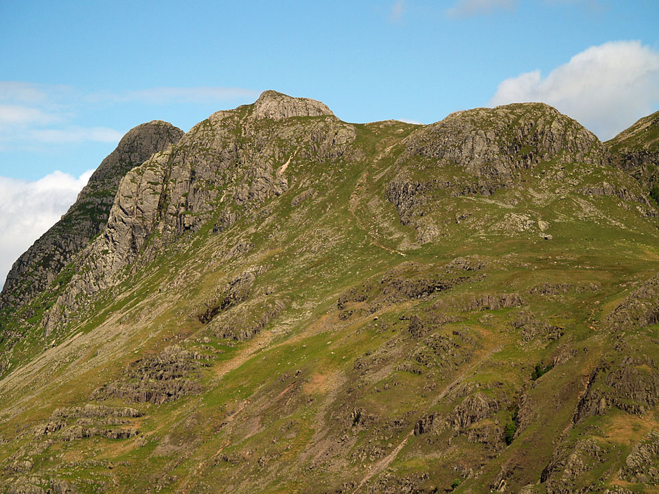
Loft Crag and Pike o’ Stickle from Thorn Crag

Harrison Stickle from Thorn Crag
Height: 642 metres / 2106 feet Grid reference: NY 28012 07131
Pike o’ Stickle, Loft Crag and Thorn Crag
Loft Crag and Pike o’ Stickle from Thorn Crag
Harrison Stickle from Thorn Crag
Start point: New Dungeon Ghyll Car Park (NY 295 064)
New Dungeon Ghyll – Stickle Tarn – Harrison Stickle – Pavey Ark – Thunacar Knott – Pike O’Stickle – Loft Crag – Thorn Crag – Pike How – New Dungeon Ghyll
Distance: 5 miles Total Ascent: 791 metres Time Taken: 3 hours 30 minutes Start Time: 09:00
Weather: Lots of wintry showers. 5°C
The weather took a turn for the worse as I climbed alongside Stickle Ghyll this morning and became really wintry on the climb to Harrison Stickle. Backed by a strong wind is was a proper winter’s day with the weather changing minute by minute. There were fleeting clear spells which were magical, but I really enjoyed every step of today’s walk – weather and all.
The Langdale Pikes Route Map.
At the start of the climb to Stickle Tarn.
Falls on Stickle Ghyll.
Lingmoor Fell and there is a bit of weather around now - sleety rain at this height but it soon turned to hail, then snow.
Looking to Pike How through the hail.
At the dam on Stickle Tarn in a heavy (and painful!) hail shower.
Heading for Harrison Stickle.
A brief interlude between the showers to look down on Stickle Tarn with distant Fairfield in view. Things soon changed however...
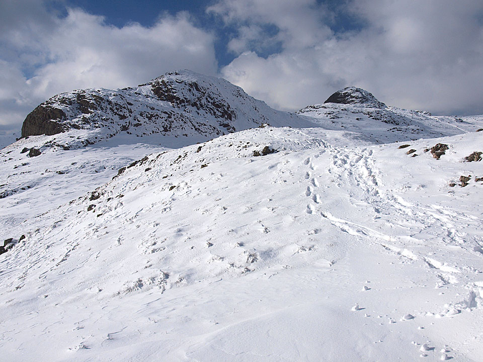
Lots of snow, lots of wind - Harrison Stickle summit ahead.
Snowy Casperoo.
Come on, let's go!
The summit of Harrison Stickle.
Pike o' Stickle from the path to Pavey Ark. Beyond there is an eerie blue light over Crinkle Crags and Bowfell.
Halo over Harrison.
For a fleeting minute of two there was full sunshine as I made my way across to Pavey Ark, here looking towards Thunacar Knott...but look at that ominous sky beyond.
Lots of drama over Harrison.
Pavey Ark
The view from the top of Pavey ark into Langdale, Windermere up to the left and Lingmoor Fell central.
High Raise is under there somewhere, Sergeant Man visible to the right.
The Vale of Grasmere from Pavey Ark.
Sunshine and clouds over the Coniston fells.
Harrison Stickle from Thunacar Knott just before I was completely enveloped in another snow shower.
Thunacar Knott.
The boys find their own path to Pike o' Stickle.
The Langdale Pikes from the path to Pike o' Stickle.
Looks like it is sunny and bright to the north.
Pike o' Stickle panoramic.
Made it to the top of Pike o' Stickle.
Mickleden.
Mono Bowfell.
Crinkle Crags close-up.
Crinkle Crags and The Band.
Harrison Stickle and Loft Crag from Pike o' Stickle.
A wider view of the same, Blea Tarn to the right.
Pike o' Stickle from the start of the Loft Crag ridge, Bowfell summit is clear of cloud to the left now.
Heading for Loft Crag.
Looking back to Loft Crag and Pike o' Stickle from Thorn Crag.
Harrison Stickle from Pike How.
The Langdale Pikes from Elterwater - it hardly looks as though there has been any snow up there now.


Start point: New Dungeon Ghyll Car Park (NY 295 064)
New Dungeon Ghyll – Stickle Tarn – Pavey Ark – Thunacar Knott – Harrison Stickle – Pike O’Stickle – Loft Crag – Thorn Crag – New Dungeon Ghyll
Distance: 5 miles Total Ascent: 770 metres Time Taken: 4 hours 30 minutes
Weather: Cold out of the sun, clear. 3°C
What a day after the heavy snow in the south Lakes yesterday, the sun was shining for most of the time and the snow was powder perfect. I had a walk with StridingEdge stalwart Andy Lang around the Langdale Pikes and it was quiet up there – we only saw a few fellow walkers from afar today. Over on St Sunday, the big news is that there was an avalanche at the top of Pinnacle Ridge which required a rescue.


All looks clear over Pike How at the start of the walk.

Heading up the Stickle Ghyll path.

Lingmoor Fell from Stickle Ghyll.

It was icy up here.

Almost at Stickle Tarn.

Pavey Ark across frozen Stickle Tarn.

Harrison Stickle along the dam wall.

Pavey Ark reflection.

Rounding Stickle Tarn.

Pavey Ark.

Sunshine and snow.

Jack's Rake to the left, Easy Gully to the right on the face of Pavey Ark. We are climbing the North Rake, round to the right of this photo.

A final view of Harrison Stickle across Stickle Tarn before heading up the rake.

North Rake.

Looking towards Fairfield from the top of the North Rake.

Casper and Dougal in the deep snow approaching the summit of Pavey Ark.

Harrison Stickle from Pavey Ark.

Looking south from Pavey Ark.

Bowfell and Thunacar Knott from Pavey Ark.

Looking back to Pavey Ark on the way to Thunacar Knott.

Looking across to the Scafells from Thunacar Knott.

Casperrrr.

Dooog-al.

Andy checks out the view - that's Great Gable up to the right - whilst Dougal checks out - well, me!

Looking across to last weeks walks - Bowfell and Esk Pike with Rossett Pike in the foreground.

Pike o' Stickle and the Coniston fells.

Andy hangs onto Dougal whilst Casper can't believe his eyes.

It started clouding over on the way to Harrison Stickle and to the north the weather was really closing in.

Dougal shows Andy the way down from Harrison Stickle heading across to Pike o' Stickle.

Clouds coming in.

It's all looking a bit ominous over there.

The climb to Pike o' Stickle was a slippery affair, here looking down to Mickleden and Oxendale, split by The Band. Crampons were required for the descent which made things a bit easier.

A panoramic view of Mickleden from Pike o' Stickle. Select on the image to see a larger version.

Yours truly and the two dogs (photo by Andy Lang).

The skies are clearing again heading across to Loft Crag.

Pike o' Stickle.

Loft Crag and Pike o' Stickle from Thorn Crag.

Great Langdale and Windermere in view.

Looking back at the route of descent.

Beautiful sunshine once more over the Coniston fells and Pike o' Blisco.

Harrison Stickle and Pavey Ark.

Looking at Stickle Ghyll and our route of ascent this morning.

Dungeon Ghyll.

Great Langdale finally gets some sunshine.
Start point: Stickle Tarn Car Park (NY 295 064)
New Dungeon Ghyll – Loft Crag – Thorn Crag – Pike O’Stickle – Martcrag Moor – Stake Pass – Mickleden – New Dungeon Ghyll
Distance: 5.8 miles Total Ascent: 677 metres Time Taken: 3 hours
Weather: Cold and wet on the tops. 10°C.
I was up and about early this morning and initially it looked promising as though it might turn out beautiful and sunny as it has been over the last few days. In fact it turned out to be completely the opposite as I got a good soaking and so opted to complete only half of the intended route (fair weather walker!). Casper has had a makeover too…

Langdale Pikes route map.

Holme Fell reflected in Yew Tree Tarn with the early morning mist rising from the water.

Yew Tree Tarn reflections.

Sunrise on the Langdale Pikes.

Pike How and Tarn Crag, Pavey Ark is visible in the distant centre.

Great Langdale sunrise.

Looking up towards Loft Crag. It looks like Casper has hired a stunt dog for the day!

Crinkle Crags have a good covering of cloud this morning.

Dungeon Ghyll.

The mist is starting to envelop me now here looking across Great Langdale to Lingmoor Fell and Side Pike, Blea Tarn is also in view.

Misty Great Langdale.

How now foxy loxy? I bet Casper is as glad of his haircut as I was that I managed to remember to wear sun cream, shorts and t-shirt!

Heading for Pike o' Stickle and this is as good as it gets. There was a really cold wind up here now so it was hat and gloves time.

Pike o' Stickle summit and now it was raining so it full waterproofs time as well. In fact it was completely miserable so I headed across boggy Martcrag Moor and decided to get down to valley level at Stake Pass. Thank goodness for GPS too, the most valuable time saving piece of fell walking equipment you can buy.

Almost into Mickleden at the bottom of Stake Pass.

Mickleden looking towards Rossett Gill and Stake Pass.

Raven Crag.
Start point: New Dungeon Ghyll Car Park (NY 295 064)
New Dungeon Ghyll – Stickle Tarn – Pavey Ark – Sergeant Man – High Raise – Thunacar Knott – Pike O’Stickle – Loft Crag – Thorn Crag – New Dungeon Ghyll
Distance: 7 miles Total Ascent: 822 metres Time Taken: 4 hours
Weather: Sunny and bright, lots of snow. 7ºC.
What a fantastic day today, the best of the winter by far I think. I knew it was going to be good when I went through Coniston and the snow was down to a low level and the sky was clear. We were nice and early, climbing alongside Stickle Ghyll to meet the sunrise half way up which gave a lovely red hue on the snow. When I reached the dam on Stickle Tarn, I thought I must have died and gone to heaven – this is how winters should be!


Stickle Ghyll.

Climbing alongside Stickle Ghyll into the fabulous sunrise.

Pike Howe across Stickle Ghyll.

Harrison Stickle and Stickle Ghyll.

Lingmoor Fell.

There was a strong, icy wind at Stickle Tarn.

Harrison Stickle from the dam on Stickle Tarn.

Pavey Ark.

Harrison Stickle, Stickle Tarn and Bright Beck.

The Coniston fells across Stickle Tarn.

Casper with snowy nose.

Looking north to Sergeant Man from the climb to Pavey Ark.

The summit of Pavey Ark.

The Helvellyn range from the summit.

Casper in the sunshine which belies the cold wind up here.

Harrison Stickle from Pavey Ark.

High Raise from the summit wall.

Looking back to Thunacar Knott from the path to Sergeant Man - only two sets of footprints up here this morning.

Icicles on Sergeant Man with a view to distant Windermere.

Crinkle Crags, Bowfell and Esk Pike from Sergeant Man.

Pavey Ark and Harrison Stickle with the Coniston fells beyond.

Helvellyn and Fairfield to the east.

Bowfell from a cold looking summit.

The mist was swirling on and off the summit of High Raise.

Looking northwards to Skiddaw it looks as though there is less snow up that way.

The northern and coldest side of High Raise.

Great End and the Scafells.

Bowfell.

Esk Pike and the Scafells.

Great Gable looks like it is on fire with the great plume of cloud emanating from the top.

Cold wind shelter on Thunacar Knott.

Bowfell from the summit of Thunacar Knott.

Pike o' Stickle and the Crinkle Crags.

Heading for Pike o' Stickle.

Monochrome.

Looking across Mickleden to Bowfell, Rossett Gill to the right.

Crinkle Crags across The Band.

Lingmoor Fell and the Coniston fells across Mickleden and Oxendale.

Looking to Loft Crag and Windermere from the descent of Pike o' Stickle. Harrison Stickle is on the left.

Bowfell and Pike o' Stickle from Loft Crag.

Harrison Stickle.

Crossing Dungeon Ghyll.

Pike o' Blisco with Coniston beyond from the descent to Great Langdale.

Loft Crag and Gimmer Crag.

Almost back to valley level.

The Langdale Pikes from Chapel Stile.
Start point: New Dungeon Ghyll Car Park (NY 295 064)
New Dungeon Ghyll – Stickle Tarn – Pavey Ark – Thunacar Knott – Harrison Stickle – Pike O’Stickle – Loft Crag – Thorn Crag – New Dungeon Ghyll
Distance: 5 miles Total Ascent: 770 metres Time Taken: 3 hours
Weather: Showers. 16oC.
The early bird caught the worm this morning! We were up at the crack of dawn today for a circuit of The Langdale Pikes. Setting off in the rain, I didn’t hold out much hope for any dry weather but fortunately it wasn’t too long before the skies cleared somewhat, although elsewhere – notably over to Bow Fell and the Coniston fells – the clouds remained down for most of the time during the morning.


Stickle Ghyll at the start of the walk...

...in the rain.

As we climbed, the rain stopped for a while and here the early morning sun catches Lingmoor Fell across Great Langdale.

Pavey Ark from the outflow of Stickle Tarn.

Pavey Ark and Stickle Tarn.

Harrison Stickle reflected in Stickle Tarn.

Sergeant Man from the climb to Pavey Ark.

A shower coming over from Easedale from Pavey Ark. Time to get the jacket on again!

High Raise and Sergeant Man from Thunacar Knott. This photo doesn't convey how bad the conditions were - it was blowing a hooly, raining and absolutely freezing up here. Wish I'd packed some gloves.

Looking down on Stickle Tarn, crossing from Thunacar Knott to Harrison Stickle.

Pike o' Blisco from Harrison Stickle.

Another shower approaches the summit of Harrison Stickle, here looking towards Windermere.

Bow Fell and Esk Pike in the clouds with Rossett Pike centre and the next objective, Pike o' Stickle, from Harrison Stickle.

Mickleden from Pike o' Stickle with Bow Fell at its head, Esk Pike and Great End beyond. The prominent fork is the joining of the Rossett Gill and Stake Pass paths.

Looking across to Loft Crag with Windermere beyond.

Rossett Pike.

Casper on Pike o' Stickle.

Bow Fell, almost out of the clouds now.

The sun lights up Loft Crag with the familiar outline of Pike o' Stickle in shade and the dark silhouette of Glaramara beyond.

Tongue out on Loft Crag for Casper.

Harrison Stickle from Loft Crag.

Casper contemplates life from Dungeon Ghyll.

Looking across to the Coniston fells, The Old Man in cloud whilst Wetherlam remains clear. To the left is Blea Tarn.

The heathery slopes of Lingmoor Fell and Side Pike.

Looking back to Loft Crag and Harrison Stickle from the bottom of the Dungeon Ghyll path.
Start point: New Dungeon Ghyll Car Park (NY 295 064)
New Dungeon Ghyll – Sergeant Man – High Raise – Thunacar Knott – Pavey Ark – Harrison Stickle –Pike O’Stickle – Loft Crag – Thorn Crag – New Dungeon Ghyll
Distance: 8.1 miles Total Ascent: 1047 metres Time Taken: 4 hours
Weather: Overcast but clearing – warm and still. 23oC
When Angus (the ‘lost boy’ – kept a close eye on him today!), Casper and I set off from the New Dungeon Ghyll, it was quite murky but surprisingly warm. The sun threatened to break through the clouds all morning and eventually did for spells. Casper was recognised (from 1000 yards I think!) on Loft Crag by Chris and Lin, up in the area for a weeks holiday and it was nice to bump into someone who visits this website. Previously I have said I wouldn’t take Angus up on the high fells again, but how could I resist? He loves it up there…


Waterfall on Stickle Ghyll.

Looking up Stickle Ghyll.

Waterfall further up.

Pavey Ark in the mist across Stickle Tarn.

Harrison Stickle.

Stickle Tarn reflections.

Sergeant Man appears briefly from the mist with a ghostly figure on the summit.

The view from Sergeant Man.

Angus and Casper on High Raise.

The sun is trying to get through now, here reflected in a mirror finish Stickle Tarn from Pavey Ark summit.

Looking across to Harrison Stickle from Pavey Ark.

A retrospective view of Pavey Ark and Stickle Tarn.

Loft Crag and Pike o' Stickle from Harrison Stickle.

Pike o' Stickle, no missing the path to it!

Looking back to Harrison Stickle on the way to Pike o' Stickle.

Angus and Casper on the summit of Pike o' Stickle, Loft Crag beyond.

High Raise and Thunacar Knott from Pike o' Stickle. There's even a touch of blue sky now!

The familiar shape of Pike o' Stickle.

Heading for Loft Crag.

The figure on top of Pike o' Stickle gives some scale.

Angus on Loft Crag, Harrison Stickle beyond.

Loft Crag and Pike o' Stickle from Thorn Crag.

Dungeon Ghyll.

Nearly there - looking back along the Dungeon Ghyll path.
Start point: New Dungeon Ghyll Car Park (NY 295 064)
New Dungeon Ghyll – Thorn Crag – Loft Crag – Pike O’Stickle – Thunacar Knott – High Raise – Sergeant Man – Pavey Ark – Harrison Stickle – New Dungeon Ghyll
Distance: 8.2 miles Total Ascent: 1017 metres Time Taken: 3 hours 50 minutes
Weather: Warmer than of late with the tops in and out of mist all day.
A return visit to old favourites The Langdale Pikes today – it’s a little while since I’ve done them so this round made a nice change today. With it being Easter soon, this area becomes very busy so I thought I’d better get out while the place was virtually deserted…

The Langdale Pikes route map.

3D image of the walk route.

Pike O' Blisco and Great Knott across Oxendale from the ascent to Thorn Crag.

Lingmoor Fell and Side Pike across The Langdale Valley.

Pike O' Stickle from Loft Crag.

The mist hangs on Loft Crag from Pike O' Stickle.

The Langdale Pikes from the back, on the way to Thunacar Knott. Thorn Crag - extreme left, Loft Crag - left of centre and Pike O'Stickle, right.

The frozen summit tarn on Thunacar Knott.

High Raise summit looking along Langstrath. Happy Birthday Angus - 9 yesterday!

Bow Fell and Esk Pike.

Easterly view from Pavey Ark.

Looking along Great Langdale to Windermere from Pavey Ark.

Harrison Stickle from Pavey Ark.

Waterfall below Thorn Crag.

Looking along Oxendale at the end of the walk, the cloud has cleared now.
Start point: New Dungeon Ghyll Car Park (NY 295 064)
New Dungeon Ghyll – Stickle Tarn – Jack’s Rake – Pavey Ark (28) – Thunacar Knott (29) – Harrison Stickle (30) – Thorn Crag (31) – Loft Crag (32) – Pike O’Stickle (33) – Martcrag Moor – Black Crag (Mickleden) (34) – Buck Pike (Mickleden) (35) – Rossett Pike (36) – Rossett Gill – Mickleden – New Dungeon Ghyll
Weather: Sunny, some cloudy spells.


Pavey Ark across Stickle Tarn. The vee shows Jack's Rake to the left and Easy Gulley to the right.

Harrison Stickle from Stickle Tarn.

The approach to and looking up Jack's Rake.


Stickle Tarn and Lingmoor Fell from Jack's Rake.

Two views ascending Jack's Rake.


The view from Pavey Ark summit. Windermere and Elterwater are on the left, Esthwaite Water on the right.

Great End, Great Gable and Glaramara from Thunacar Knott summit.

Windermere and Lingmoor Fell from Harrison Stickle summit.

Pike O'Stickle from the summit of Thorn Crag.

Crinkle Crags from Loft Crag summit.

The Coniston Fells from Pike O'Stickle summit.

The Langdale Pikes and Mickleden from Black Crag summit.

Esk Pike and Great End from Buck Pike summit.

The Langdale Pikes and High Raise from Rossett Pike summit.

Angle Tarn from Hanging Knotts.

Looking down Rossett Gill to Mickleden.