Height: 660 metres / 2165 feet Grid reference: NY 18021 18977 Category: The North Western Fells
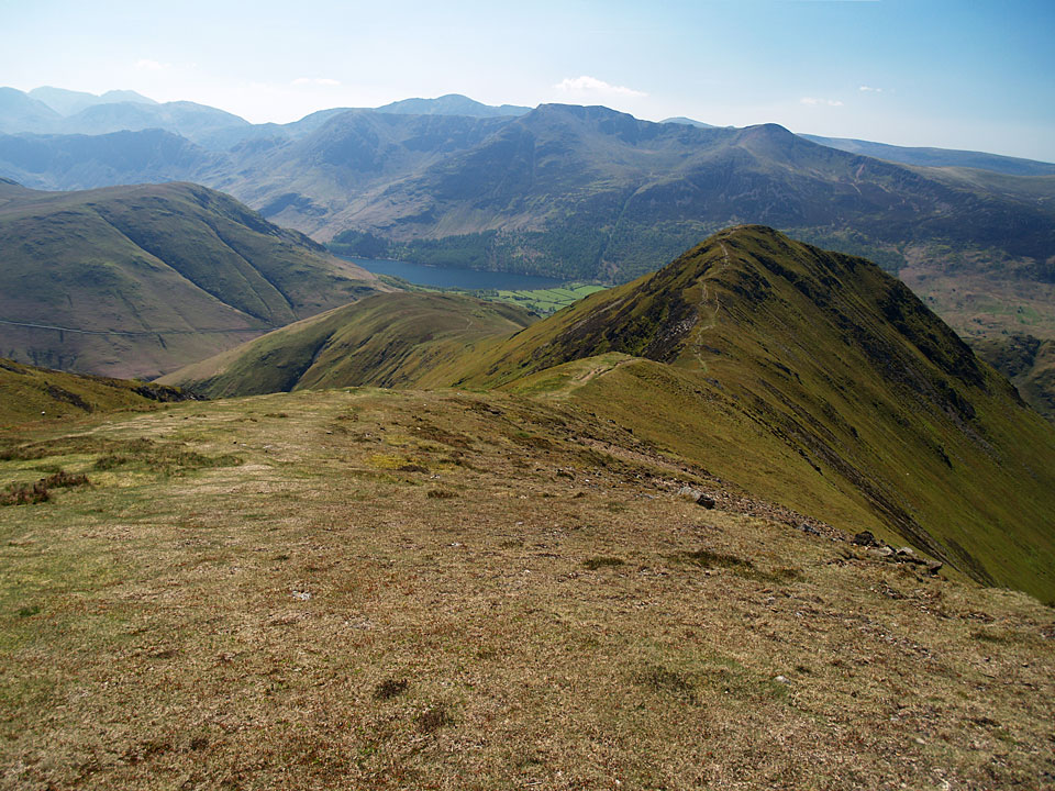
Whiteless Pike ahead
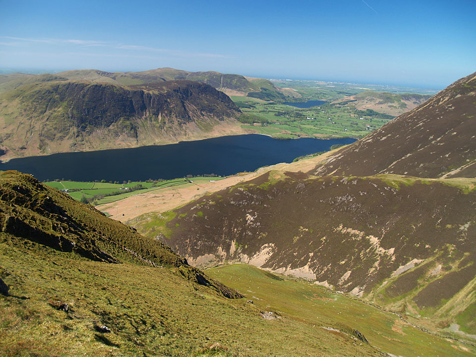
Crummock Water with Loweswater beyond from Whiteless Pike
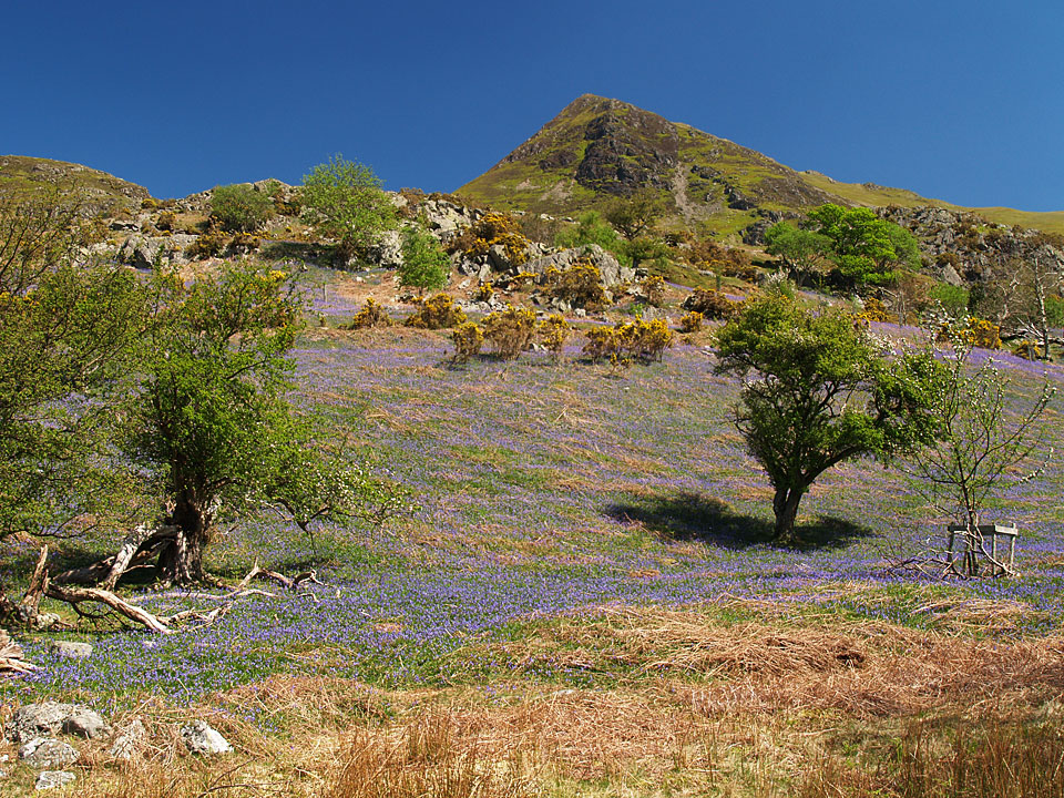
Whiteless Pike from Rannerdale
Height: 660 metres / 2165 feet Grid reference: NY 18021 18977 Category: The North Western Fells
Whiteless Pike ahead
Crummock Water with Loweswater beyond from Whiteless Pike
Whiteless Pike from Rannerdale
Start point: Lanthwaite Green (NY 159 208)
Lanthwaite Green – Grasmoor – Crag Hill – Wandope – Thirdgill Head Man – Whiteless Pike – Whiteless Breast – Low Bank – Rannerdale Knotts – Lanthwaite Green
Distance: 7.1 miles Total Ascent: 1038 metres Time Taken: 4 hours Start Time: 09:00
Weather: Cold, very clear. 2°C
As I passed through Ambleside In could see the blood red sky to the south east catching me. As I went through Keswick, I could see a lovely inversion forming over Derwent Water but I managed to press on regardless despite these fantastic condition to head for Buttermere. I was rewarded with the shot I wanted across early morning Buttermere and then a walk in absolute clarity on the north western fells, taking in Grasmoor by the direct route from Lanthwaite Green – a steep one and not for the faint hearted. As Wainwright described it ‘On the whole, however, the climb is probably less difficult than the North Wall of the Eiger’!

Dawn at Buttermere.

Pink sky.

Beautiful red sky and reflections looking to Fleetwith Pike.

Grasmoor direct Route Map.

This photo was taken after the walk but shows today's route of ascent to Grasmoor - straight up!

Early morning Mellbreak from Lanthwaite Green.

At the foot of the (gulp!) climb.

Love the sky.

Low lying cloud in the Crummock Valley.

Climbing the scree slope.

Mellbreak from the scree. I was in the shade for the whole climb being on the north face of Grasmoor.

The Loweswater Fells.

Carling Knott and Burnbank Fell.

At the top of the grassy rake looking towards Whiteside.

There were many photos of Mellbreak today but there are great views from here.

Loweswater.

Whiteside and Gasgale Gill.

The view from the Pinnacle.

Climbing to Grasmoor End.

Made it...

...but there's still a fair walk to get to the summit from here. At least the going is easier and I am in the sunshine now

Would you like ice with your drink Dougal?

Dougal on the frosty summit.

Grasmoor summit.

Looking into the sunshine towards the Scafells.

Hopegill Head.

Hopegill Head, Grisedale Pike and Skiddaw from Dove Crags.

Fabulous views for miles today.

Layers upon layers of fells.

Distant Skiddaw and Blencathra.

Looking back to the top of Grasmoor.

Crag Hill within touching distance. It wasn't on the agenda...but go on then.

Frozen pool at the crossroads.

The summit of Crag Hill and that trig. column is going to collapse soon (look at the bottom left of it).

Coledale panorama - select on the image to see a larger version.

Dougal and Casper on frosted Crag Hill.

Grasmoor from the descent.

Wandope.

Crag Hill from Wandope summit.

Whiteless Edge and Whiteless Pike from Thirdgill Head.

Looking back to Thirdgill Head and Wandope.

A view through to Helvellyn from Whiteless Pike, Ard Crags and Knott Rigg in the foreground.

Looking back from the descent of Whiteless Pike.

Rannerdale Knotts from Whiteless Breast.

Low Bank.

Crummock Water and Loweswater from Rannerdale Knotts summit.

Whiteless Pike looks shapely from here.

Descending towards Crummock Water and Mellbreak.

Grasmoor from Lanthwaite Green.
Start point: Rannerdale Bridge (NY 163 192)
Rannerdale Bridge – Lad Hows (534) – Grasmoor – Crag Hill – Wandope – Thirdgill Head Man – Whiteless Pike – Whiteless Breast – Low Bank – Rannerdale Knotts – Rannerdale Bridge
Distance: 7.5 miles Total Ascent: 1080 metres Time Taken: 3 hours 30 minutes
Weather: Dull with showers. 19ºC.
There were two reasons to come to Buttermere today – to walk the Lad Hows ridge to Grasmoor and to see the Rannerdale Bluebells out in force. A third reason was that it has been warm and sunny all week, surely there would be more of the same today, or would there? I thought so as I headed off in shorts and tee shirt with plenty of sun block on…


Grasmoor from Cinderdale Common.

Cinderdale Beck.

Rannerdale Knotts from the start of the climb to Lad Hows.

Casper manages to keep still whilst the water flows around him in Cinderdale Beck.

Mellbreak across Crummock Water.

High Stile and Red Pike beyond Rannerdale Knotts.

Casper on Lad Hows.

The climb to Grasmoor from Lad Hows.

Layers of fells - the Scafells beyond Great Gable and Robinson beyond Whiteless Pike.

Buttermere from Grasmoor.

Heading for Crag Hill from Grasmoor in an odd light. The path appears continuous from here but actually dips sharply down at the point.

Thirdgill Head Man and Whiteless Pike from Grasmoor.

The summit of Crag Hill.

Casper spots the rain coming in from Keswick.

That'll wash the sun block off! Derwent Water between Outerside, Barrow and Causey Pike

Descending to Wandope.

Grasmoor from Wandope.

The view from Wandope looking over Newlands Hause.

It was bucketing down with rain now descending Whiteless Edge to Whiteless Pike from Thirdgill Head Man.

Crummock Water and Loweswater from the descent.

Great Gable, Pillar and Haystacks across Buttermere.

High Stile from Rannerdale Knotts.

Mellbreak across Crummock Water from the desecnt of Rannerdale Knotts.

Heading into Rannerdale.

All Bluebells are blue.

Mellbreak and Rannerdale.

Casper in Bluebell city.
Start point: Rannerdale Bridge (NY 163 192)
Rannerdale Bridge – Whin Ben – Whiteside – Gasgale Crags – East Top of Whiteside – Hopegill Head – Sand Hill – Grasmoor – Wandope –Thirdgill Head Man – Whiteless Pike – Whiteless Breast – Low Bank – Rannerdale Knotts – Rannerdale Bridge
Distance: 9.7 miles Total Ascent: 1190 metres Time Taken: 4 hours 15 minutes
Weather: Fine and sunny with a cool breeze on the top again. 21oC.
Today’s conditions were almost perfect. Not a cloud in the sky, which was a beautiful azure, and the sun was shining and warm – warm enough for shorts and t-shirt for the full round. It was just me and Casper today, Angus stayed home and had a lie in whilst Casper gave his new haircut a run out.


Grasmoor from Rannerdale Bridge at the start of the walk.

The Loweswater Fells across Crummock Water.

Whiteside and Whin Benn - that's a steep way up!

Liza Beck and Loweswater.

Mellbreak.

Who is that skinny young thing looking towards Hopegill Head?

The Whiteside ridge.

The path to Hopegill Head with Grisedale Pike beyond from the east top of Whiteside.

Looking back along the Hopegill Head arête to Whiteside.

Grasmoor from Sand Hill.

Skiddaw, Blencathra and the Coledale Valley from the climb to Grasmoor.

Rannerdale Knotts from Grasmoor, the swathes of Bluebells can be seen below it even from here.

Crag Hill and Sail from Wandope.

Grasmoor from Wandope.

Casper was all skin and bone beneath all that hair!

'Who, me?'

Heading for Whiteless Pike.

Looking back to Thirdgill Head and Wandope.

Crummock Water with Loweswater beyond.

Heading down for Rannerdale Knotts.

Buttermere.

The view from Rannerdale Knotts summit.

Mellbreak across Crummock Water - straight in for Casper!

The famous Rannerdale Bluebells are in full force, here looking to Grasmoor.

Whiteless Pike from Rannerdale.

More Bluebells.

All was sweet smelling here with the gorse and flowers.

One more shot of them.
Start point: Lanthwaite Green (NY 159 208)
Lanthwaite Green – Whin Ben – Whiteside (349) – Gasgale Crags (350) – East Top of Whiteside (351) – Hopegill Head – Sand Hill – Grasmoor (352) – Wandope (353) – Thirdgill Head Man (354) – Whiteless Pike (355) – Whiteless Breast – Low Bank – Rannerdale Knotts (356) – Rannerdale – Lanthwaite Green
Distance: 10.1 miles Total Ascent: 1943 metres Time Taken: 3 hours 55 minutes
Weather: Dull and overcast, rain later. 10oC.
The cloud was lying heavily on the higher tops today, so I knew there wouldn’t be any views from my round of Grasmoor. The wind was howling and quite cold, there was a great moment descending to Whiteless Pike when the mist cleared all of a sudden and I was rewarded with great views; five minutes later the mist and drizzle closed back in. I descended Rannerdale Knotts into Rannerdale to see the famous Bluebells, now in bloom and well worth a visit.

Grasmoor route map.

Whin Ben with Whiteside lost in the mist behind.

Mellbreak across Crummock Water.

Loweswater.

The arête to Hopegill Head is a mini-Striding Edge, totally lost in the clag today.

A bit of a breeze on Thirdgill Head Man!

Descending through the mist to Whiteless Pike.

Mellbreak and Crummock Water.

Looking back to Thirdgill Head Man, left, and Wandope to the right.

Crummock Water and Loweswater.

Rannerdale Knotts.

Loweswater, Crummock Water and the Loweswater Fells from Rannerdale Knotts.

Whiteless Pike from Rannerdale Knotts.

The Bluebells are out at Rannerdale...

...lots of them.

Rannerdale.
Lanthwaite Green – Whin Ben – Whiteside (116) – Hopegill Head – Sand Hill – Grasmoor (117) – Wandope (118) – Thirdgill Head Man – Whiteless Pike (119) – Whiteless Breast – Low Bank – Rannerdale Knotts (120) – Rannerdale – Lanthwaite Green

Whiteside and Whin Ben at the start of the walk.

Carling Knott and Burnbank Fell to the left of Loweswater, Low Fell to the right.

The Hopegill Head Ridge from Whiteside's summit.

Mellbreak across Crummock Water from Whiteside's East summit cairn.

Shelter on Grasmoor summit.

The Scafell Pikes across Buttermere from Grasmoor.

The Helvellyn ridge in the distance from Wandope's summit.

Knott Rigg from Wandope.

Mellbreak across Crummock Water from Thirdgill Head Man.

Thirdgill Head and Wandope from Whiteless Pike's summit.

Rannerdale Knotts, Mellbreak, Crummock Water and Loweswater.

Crummock Water and Loweswater from Rannerdale Knotts summit.

Buttermere from Rannerdale Knotts summit.

Mellbreak.

Whiteless Pike from Lanthwaite Green.