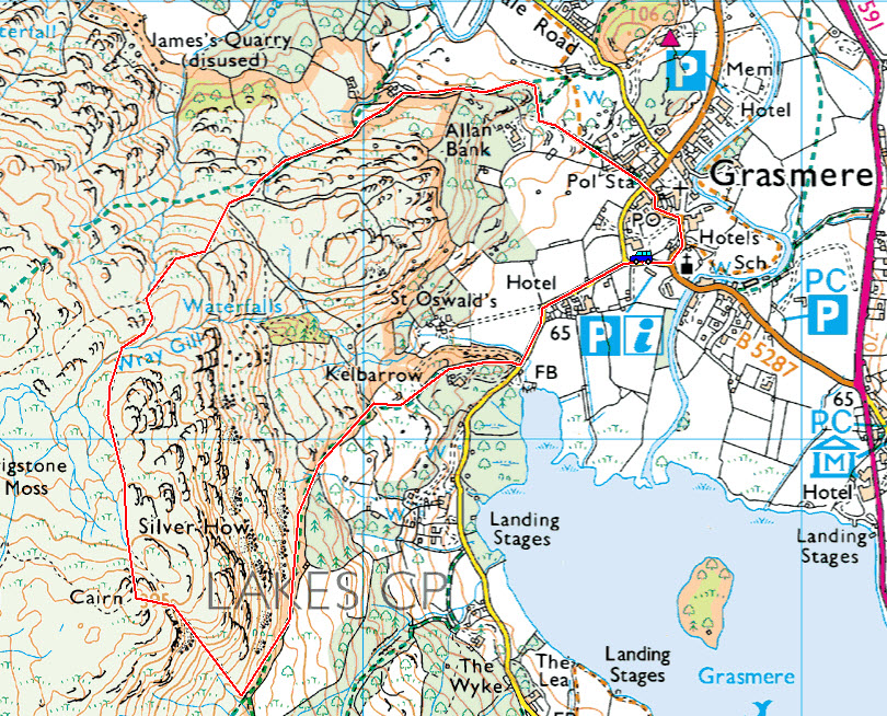
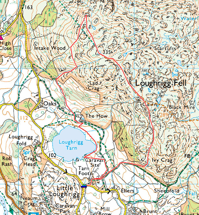
Striding Edge

A photo diary of Lake District fell walks

  • Walks
  • Fells
    • Wainwrights
      • Eastern Fells
      • Far Eastern Fells
      • Central Fells
      • Southern Fells
      • Northern Fells
      • North Western Fells
      • Western Fells
      • Outlying Fells
    • Birketts
  • Dogs
  • Love The Lakes
  • Contact

Devoke Water

Walked on 13/09/2014

Start Point: Birker Fell road (SD 171 977)

Birker Fell Road – Rough Crag (Birker Moor) (OF) – Water Crag (OF) – Seat How (Birker Moor) (OF) – Birker Fell Road

Distance: 3 miles Total Ascent: 190 metres Time Taken: 1 hour 15 minutes Start Time: 14:00

Weather: Warm but overcast, 19°C

I had enough time for a quick walk around Devoke Water this afternoon – it is guaranteed to be far from the madding crowd up here even at the weekend.

Devoke Water

610_5465

Firstly, a few photos from this week (they are available to view on Facebook at the time they are taken if you want to keep up to date). Windermere sunset.

610_5470

Heaven.

610_5475

Moon over Helvellyn.

610_5485

Martian landscape or the west coast of Cumbria?

610_5498

Setting sun.

610_5504

Fun and frolics in the last bit of daylight.

610_5535

Harter Fell and Green Crag. It was a bit of a funny day being really warm hazy and overcast.

610_5537

Fletcher progress report: he is off the lead on the fells and loving it! He is such a good lad, sticks by my side and not particularly interested in sheep - only out of curiosity really. He is going to be a fell maestro for sure...

610_5543

Hazy Scafell.

610_5547

Above Devoke Water.

610_5561

Heading for Water Crag.

610_5564

Rough Crag from Water Crag.

610_5570

Fletcher.

610_5584

Tongue competition.

610_5588

Woodend Height and Yoadcastle.

610_5591

Seat How.

610_5597

Devoke Water swimming club.

610_5598

Walking on water.

610_5605

The old boathouse.

610_5611

Devoke Water from Seat How.

610_5632

'Look what I've found!' - not sure of the significance of this on top of Seat How.

610_5638

Gimmers - a face in the crowd.

Caw and the Coniston Fells

Walked on 01/09/2014

Start Point: Kiln Bank Cross (SD 215 933)

Seathwaite – Park Head Road – Caw (OF) – Pikes (OF) – White Pike – White Maiden – Walna Scar (OF) – Walna Scar Road – Seathwaite

Distance: 7.8 miles     Total Ascent: 773 metres     Time Taken: 3 hours 20 minutes     Start Time: 13:00

Weather: Generally overcast, 17°C

The weather was supposed to clear later in the day, unfortunately that never materialised but I was enjoying the fresh air so much I extended a planed shorter walk to Caw by linking it to the Coniston fells. It was an unusual route but it was worth it to see if it could be done (the answer is yes, but recommended? Probably not!).

610_5324

Seathwaite and Wallowbarrow Crag from the Park Head Road.

610_5325

Seasonal fungi.

610_5330

Climbing the track, Fox Haw ahead.

610_5331

Looking back along the Duddon Valley, Bowfell at its head. Shortly after this the path doubles back on itself to climb Caw.

610_5337

Climbing through the old quarry workings.

610_5362

Dougal decides the route for the rest of the day.

610_5365

Black Combe and Stickle Pike from Caw.

610_5368

The next stop was Pikes, a conspicuous peak between Caw and White Pike, here looking back towards Caw from the summit.

610_5370

I've never linked Caw with the Coniston fells, so why not? I went for the mine workings central in this photo - it was a bit boggy to say the least!

610_5380

Harter Fell and the Scafells from the quarries on the slopes of White Pike.

610_5384

A steep climb brought me to the top of White Pike.

610_5387

A reverse view of one of the photos from above, looking back to Caw.

610_5395

Coniston Water from White Maiden.

610_5397

The route walked from Walna Scar. From here, I descended the Walna Scar road back to the old workings and back the boggy way I came to descend back into Seathwaite.

Dunnderdale Fells

Walked on 23/08/2014

Start Point: Kiln Bank Cross (SD 215 933)

Kiln Bank Cross – Stickle Tarn – Great Stickle (OF) – Tarn Hill (OF) – Stickle Pike (OF) – Kiln Bank Cross

Distance: 2.5 miles     Total Ascent: 235 metres     Time Taken: 1 hour 30 minutes     Start Time: 16:00

Weather: Bright and breezy, 17°C

It was another lovely afternoon and I took the chance of a late walk to get up amongst the Dunnerdale Fells. This area is always beautiful, reasonably quiet and easy for me to get to for a shorter walk. This route will appear in Trail magazine later this year.

Dunnerdale Fells Map

610_5149

Twin peaks - Great Stickle and Stickle Pike from Broughton Mills.

610_5152

Caw from the climb.

610_5156-Edit

Stickle Tarn - beautiful.

610_5159

Bring me sunshine.

610_5161

Looking along the Duddon Valley to the high fells.

610_5164

Caw and Grey Friar (in shadow) across Stickle Tarn.

610_5172

Stickle Pike towering above the path.

610_5173

The path to Great Stickle, the fell to the left.

610_5179

The Matterhorn shape of Stickle Pike - it looks fantastic from the south.

610_5185

The view from the climb to Great Stickle.

610_5192

This couple I met were enjoying the views from Great Stickle today.

610_5200

Looking towards the Duddon Estuary.

610_5209

Great Stickle from Tarn Hill.

610_5219

A lovely view across a tarn.

610_5232

At the top of Tarn Hill.

610_5241

Dougal and (windswept) Fletcher.

610_5253

On the edge of the Tarn Hill ridge. In the clearing below right, where the path joins the area without bracken there is a small stone circle.

610_5254

The stone circle.

610_5258

Rainbow over Caw.

610_5256

Scafells to Bowfell and Crinkle Crags with Harter Fell in the foreground from the foot of Stickle Pike.

610_5260

Looking across virtually the whole route from the south top of Stickle Pike.

610_5278

Stickle Pike summit.

Holme Fell

Walked on 07/08/2014

Start Point: Hodge Close (NY 315 016)

Holme Fell from Hodge Close

Distance: 1.7 miles     Total Ascent: 165 metres     Time Taken: 1 hour     Start Time: 08:50

Weather: Lovely, 17°C

What a glorious morning – so nice that I had to stop at a couple of places for an opportune photo or two on the way to Coniston. Holme Fell is fabulous at this time of year with the visually lovely and fragrant Ling in abundance.

Holme Fell Map

610_5020-Edit

The view from the Scott Memorial.

610_5034

Reflected trees.

610_5042

Calm water looking across to Wetherlam.

610_5048

Similar but different.

610_5054

The old reservoir at the foot of Holme Fell.

610_5060

The view across to the Langdale Pikes.

610_5081-Edit

The summit of Holme Fell with lots of fragrant Ling all around.

610_5088-Edit

Looking along Coniston Water.

610_5112

A heathery view.

610_5125

Dougal.

610_5133

Wetherlam.

610_5137-Edit

The view to Fairfield and the eastern fells.

610_5145

Back down at the reservoir.

610_5147

The smaller second reservoir.

610_5148

Ivy Crag left, Holme Fell right.

Latterbarrow

Walked on 05/08/2014

Start Point: Colthouse (SD 360 988)

Latterbarrow (OF) from Colthouse

Distance: 1.5 miles     Total Ascent: 143 metres     Time Taken: 1 hour     Start Time: 10:35

Weather: Warm and muggy, 20°C

We have been away for a couple of weeks to sunnier climes so today was the day to spring the two heroes from  holidays at the kennels. We kept the walk short and sweet to suit young Fletcher and it was really quite warm up there today. It was hard to believe how much Fletcher has grown over the last couple of weeks whilst Dougal seems to have shrunk due to another summer haircut!

Latterbarrow Map

610_4908

Tranquil Esthwaite Water.

610_4914

The Coniston fells from the start of the climb to Latterbarrow.

610_4919

A close up, from higher up.

610_4927

Connie is growing up too quickly.

610_4934

Give me something to chew!

610_4939

'Are we there yet?'

610_4943

Wansfell and the Far Eastern fells across Windermere.

610_4947

Summer haircut number 2!

610_4953

I don't think Connie will be picking Fletcher up like this for much longer!

610_4966

The obelisk on Latterbarrow.

610_4989

Fletcher in pastures new.

610_4998

An amazingly rare photo of the two of them being still (almost), looking the same way (almost) and looking at the camera (almost)!

Blencathra via Gategill Fell

Walked on 21/07/2014

Start Point: Threlkeld (NY 318 256)

Threlkeld – Knott Halloo – Gategill Fell – Blencathra – Doddick Fell – Threlkeld

Distance: 4.2 miles     Total Ascent: 733 metres     Time Taken: 3 hours     Start Time: 08:40

Weather: Boiling, 22°C

It was another beautiful morning to continue the fantastic summer weather we have been enjoying recently. This walk to Blencathra from Threlkeld has a bit of a gruelling start with the climb to Knott Halloo on Gategill Fell being steeper than steep! Nice to bump into StridingEdge fans John Unsworth and Lily up on the summit today too. This walk will feature in an edition of Trail magazine later this year.

Blencathra via Gategill Fell

610_4682.jpg

Early morning Windermere.

610_4685.jpg

Four in a row, the Fairfield fells in the distance.

610_4690.jpg

Bowfell and Langdale Pikes reflections.

610_4698.jpg

Grasmere.

610_4699.jpg

Grasmere panorama.

610_4702.jpg

Helm Crag.

610_4705.jpg

Derwent Water (1)

610_4709

Derwent Water (2) + geese! On with the walk...

610_4713

Bright and green on Gategill Fell. Knott Hallo is the lump on the skyline to the right.

610_4723

Looking across to Blease Fell.

610_4724

The steep climb to Knott Halloo was hard work in this baking sunshine.

610_4729

Knott Halloo.

610_4736

Gategill Fell Top from Knott Halloo, the rock turret right of centre.

610_4742

Hot work for the Dougalster.

610_4745

This is a mighty fine ridge.

610_4749

This is a mini Striding Edge according to Wainwright.

610_4756

Looking back down from the steep section near the top.

610_4766

The ridge from the top - Knott Halloo is the furthest point on the ridge to the right.

610_4767

The back o' Skiddaw.

610_4770

The view to Derwent Water and the north western fells.

610_4776

Central is the Doddick Fell ridge, the one I will use in descent.

610_4777

Gategill Fell and the ridge recently ascended from the summit of Blencathra.

610_4780

Dougal at the summit.

610_4789

Looking back to the summit from the top of Doddick Fell.

610_4791

Looking down the Doddick Fell ridge from Doddick Fell Top.

610_4798

Doddick Gill.

610_4804

It was thirsty work today.

610_4807

Gate Gill - dry as a bone.

Brock Barrow

Walked on 11/07/2014

Start Point: High Nibthwaite (SD 294 897)

Brock Barrow (OF) from High Nibthwaite

Distance: 1.5 miles     Total Ascent: 175 metres     Time Taken: 1 hour     Start Time: 13:30

Weather: Boiling, 25°C

Today seemed as good a day as any to get out on the fells with young Fletcher – of course, with him being so young it had to be short and sweet but he seemed to take to it okay even in the hottest of summer conditions. It was absolutely gorgeous up there today, certainly the warmest weather I have been out in for a while.


610_4568

All is bright and all is green at the start of the walk from High Nibthwaite.

610_4569

Looking across Allan Tarn.

610_4570

Brock Barrow - lots of heat and lots of flies for us to contend with today.

610_4574

The Coniston fells from the top of Brock Barrow.

610_4586

Made it Fletcher - good lad!

610_4604

Fletcher has more than a hint of Casper about him.

610_4623

Heading for the second cairn.

610_4635

Hot!

610_4637

A fabulous view of Coniston Water and the fells.

610_4646

Keeping an eye on things.

610_4658

Back down at Coniston Water.

610_4663

That looks like a good place to be.

610_4676

Fletcher is a swimmer!

610_4681

Our old friend keeping an eye on proceedings.

Esk Pike

Walked on 09/07/2014

Start Point: Cockley Beck (NY 246 016)

Cockley Beck – Moasdale – Lingcove Beck – High Gait Crags – Yeastyrigg Crags – Pike de Bield – Esk Pike – Ore Gap – Bowfell – Three Tarns – Shelter Crags – Crinkle Crags – Stonesty Pike – Little Stand – Ulpha Fell – Cockley Beck

Distance: 9 miles     Total Ascent: 1013 metres     Time Taken: 6 hours     Start Time: 07:30

Weather: Lovely, 21°C

It was perfect summer weather for a walk up to Esk Pike from Cockley Beck – this is definitely the quiet way to do these fells and I didn’t see anyone until 3 Tarns and then one or two on Crinkle Crags. By the end I was completely boiled, but hey – not complaining! This walk will feature in Trail magazine later this year.

Esk Pike Map

610_4417

First sight of the Scafells from Moasdale this morning - lovely.

610_4419

Scafell and Scafell Pike before heading down to cross Lingcove Beck.

610_4424

The south ridge to Esk Pike in the foreground.

610_4435

Close up on Scafell Pike, Scafell to the left and Ill Crag to the right.

610_4438_stitch-Edit

Scafells panorama.

610_4438

Fine views from High Gait Crags.

610_4441

Mono Pike.

610_4447

The King of the Fells and the fell that is king.

610_4456

Looking back along the ridge to Hard Knott and Harter Fell.

610_4460

The Lion King.

610_4465

Climbing higher across Yeastyrigg Crags.

610_4474

Looking across Pike de Bield to the Scafells. Further along from Pike de Bield is a large cairn (marked 'memorial cairn' on 2nd edition Wainwright's), the brass plaque on it says 'Gerry Charnley 1929 - 1982.

610_4494

Langstrath from Esk Pike summit. Esk Pike and Bowfell were swirling in and out of the mist all morning and it was a shock to hit the cold air.

610_4501

Heading for Bowfell across Ore Gap.

610_4505

The dark outline is the south ridge of Esk Pike (just climbed) and beyond is the finest view of the Scafells of all, taken from Bowfell.

610_4511

The Great Slab of Flat Crags and the Langdales.

610_4512

Crinkle Crags across Three Tarns.

610_4516

Down at the tarns and a chance for Dougal to cool off.

610_4527

Pike o' Blisco, Windermere beyond from Crinkle Crags.

610_4534

The highest swimmer in England at 854m in Crinkle Crags Tarn.

610_4538

Rounding Long Top, Dougal checks out the way across the fifth (or first!) Crinkle and over to Stonesty Pike and Little Stand.

610_4542

Great Langdale.

610_4547

Stonesty Pike summit - I think Birkett got the wrong one when he chose it.

610_4559

Beautiful weather and pools on Little Stand.

610_4563

The Duddon Valley from the descent of Little Stand.

610_4566

Looking back up from the road - there is a way down somewhere!

Coniston Fells

Walked on 07/07/2014

Start Point: Walna Scar road (SD 289 970)

Walna Scar road – Coniston Old Man – Brim Fell – Levers Hawse – Great How – Great Carrs – Swirl How – Prison Band – Swirl Hawse – Levers Water – Boulder Valley – Walna Scar road

Distance: 7 miles     Total Ascent: 862 metres     Time Taken: 4 hours     Start Time: 07:30

Weather: Some sunny spells, cool on top with showers, 16°C

The Coniston fells were shrouded in mist when I set off and they were in and out of the clouds all morning as the sun tried its best to shine through. It is a great ridge walk from The Old Man to Swirl How and a fair while since I have done it – I’m glad I did today as I enjoyed it and saw no one this Monday morning.

Coniston Fells Map

610_4314

Looking a bit grey at the start of the walk.

610_4315

...as so often happens, away from the fells it is blue sky here looking over Boo Tarn.

610_4320

The Cove.

610_4324

Coniston Water.

610_4326

Boiling clouds to the east, on the Ill Bell ridge.

610_4329

Brown Pike and Blind Tarn catch the sun.

610_4331

Low Water from The Old Man.

610_4333

he summit of The Old Man - no one here but me and Dougal (and of course we paid a visit to Angus and Casper).

610_4337

Brim Fell.

610_4348

Great Carrs, Swirl How and Great How Crags across Levers Hawse.

610_4355

Seathwaite Tarn, Harter Fell to the right.

610_4359

Brim Fell and Dow Crag from Little How Crags.

610_4362

Levers Water and Coniston Water beyond.

610_4365

The ridge just walked from The Old Man to Brim Fell, Dow Crag to the right.

610_4368

Pensive Dougal.

610_4377

Swirl How from Great Carrs.

610_4385

Nearly all in one shot - the Coniston fells from Great Carrs.

610_4391

The Royal Canadian Air Force memorial on Great Carrs, Grey Friar beyond.

610_4393

Swirl How.

610_4395

Dougal looking for the Scafells - they are over to the left and have been lost all day.

610_4400

Descending Prison Band, Wetherlam ahead.

610_4406

Down at Levers Water.

610_4409

Brim Fell end from a dry looking Levers Water. About 30 seconds after this photo the heavens opened to make a very damp end to the walk through Boulder Valley.

Beacon Fell

Walked on 26/06/2014

Start Point: At the end of the minor road from Brown Howe (SD 281 916)

Beacon Fell (OF) from Tottle Bank

Distance: 2 miles     Total Ascent: 200 metres     Time Taken: 50 minutes     Start Time: 09:30

Weather: Grey. 15°C

It was completely different weather today to that of Monday – gone was the lovely sunshine to be replaced with general murk and dreariness. Early on it was drizzling too but that soon cleared as we headed up to Beacon Fell for a bit of fresh air.

Beacon Fell Map

610_4073

Parkamoor Jetty (in the drizzle) looking across to Beacon Fell.

610_4075

Side view of the jetty.

610_4083

Beacon Fell ahead as Dougal negotiates the long grass and bracken.

610_4085

Climbing the gully to the top.

610_4088

Coniston Water from Beacon Fell. The treasure tin is still there.

610_4096

Dougal in a thoughtful pose.

610_4100

Descending to Beacon Tarn, Wool Knott at the head of it.

610_4102

Walking on water.

610_4110

The only view of the Coniston fells this morning through the grey murkiness.

Yewbarrow

Walked on 23/06/2014

Start Point: Overbeck Bridge (NY 168 068)

Overbeck Bridge – Bell Rib – Great Door – Yewbarrow (South Top) – Yewbarrow (North Top) – Dore Head – Over Beck – Overbeck Bridge

Distance: 3.9 miles     Total Ascent: 580 metres     Time Taken: 2 hours 30 minutes     Start Time: 08:30

Weather: Boiling, 21°C

Summer is here in a big way and today it was really warm early on and beautiful conditions for a walk up to Yewbarrow. Today I took out my new camera for the first time to give it a whirl, hopefully I can do it justice when I get used to it (it is a Nikon D610 with a 24-85 lens for those that are interested in such things).

Yewbarrow Map

610_3926

Early morning in Wasdale.

610_3937

Looking up to Bell Rib on the south end of Yewbarrow.

610_3948

Great Door.

610_3952

Looking over to Seatallan (yours truly, bottom!).

610_3955

The Scafells.

610_3957

Walking the ridge along Yewbarrow, Red Pike to the left.

610_3958

Stalwart of the fells in classic pose.

610_3960

Looking down on Wast Water and The Screes.

610_3962

Burnmoor Tarn.

610_3963

Kirk Fell and Great Gable from Yewbarrow summit.

610_3968

Swirling skies.

610_3973

Dougal was tripping over his tongue in this heat.

610_3979

Pillar across Dore Head.

610_3984

Red Pike and Pillar from the north top.

610_3989

Kirk Fell.

610_3994

Dougal checks the way down Stirrup Crag - the simple answer is...it is straight down.

610_3996

Looking back up from the bottom.

610_3999

Pillar from Dore Head.

610_4002

Middle Fell from Over Beck.

610_4005

Looking back on the descent.

610_4010

Portrait of Dougal.

610_4016

Dropping Crag and Bell Rib on the return.

610_4018

The Scafells in full sunshine now.

610_4019

A final view of Yewbarrow.

Scafell Pike via Pen

Walked on 11/06/2014

Start Point: Jubilee Bridge (NY 213 011)

Brotherilkeld Farm – Lingcove Bridge – Great Moss – Pen – Scafell Pike – Mickledore – Lord’s Rake – Scafell – Slight Side – Catcove Beck – Brotherilkeld Farm

Distance: 10 miles     Total Ascent: 1178 metres     Time Taken: 7 hours     Start Time: 10:50

Weather: Murky, 16°C

I had a full day available today so I wanted to do a good long walk – I did think the weather would turn out better than it did but it was still good to be out and walking in mist has its own merits of complete solitude, even on the popular fells such as this.

Scafell Pike via Pen

OLYMPUS DIGITAL CAMERA

Heading into Upper Eskdale and the mist was lying quite low on the fells. I was hopeful of it getting out later.

OLYMPUS DIGITAL CAMERA

Walking alongside the River Esk. This is a lovely and peaceful part of the lakes in any weather.

OLYMPUS DIGITAL CAMERA

Cascades on the Esk.

OLYMPUS DIGITAL CAMERA

Lingcove Bridge.

OLYMPUS DIGITAL CAMERA

...and a view of the bridge from a little higher up the path to Great Moss.

OLYMPUS DIGITAL CAMERA

On the climb to Pen - the briefest glimpse of Scafell.

OLYMPUS DIGITAL CAMERA

Esk Buttress - and that was it for views for a good while. I climbed the steep path to Pen (the top took a bit of finding as I could hardly see my hand in front of me!) then over to Scafell Pike.

OLYMPUS DIGITAL CAMERA

Heading down to Mickledore.

OLYMPUS DIGITAL CAMERA

Looking back to Scafell Pike - the blue sky did appear (if only fleetingly).

OLYMPUS DIGITAL CAMERA

Pulpit Rock from the foot of Lord's Rake. I was surprised to see how much the path from Mickledore to Lord's Rake has eroded recently.

OLYMPUS DIGITAL CAMERA

Lord's Rake.

OLYMPUS DIGITAL CAMERA

The chock stone is still standing although there seems to be more large boulders around it. Up on Scafell it was as misty as it was on the Pike - I chatted for a while to a couple who were completing their 214 up there, congratulations to both.

OLYMPUS DIGITAL CAMERA

Dougal, my ever faithful friend.

OLYMPUS DIGITAL CAMERA

Looking back to Scafell from Long Green. There were lots of Brocken Spectres to see along here with the sun trying to shine through.

OLYMPUS DIGITAL CAMERA

Slight Side summit.

OLYMPUS DIGITAL CAMERA

Slight Side from the descent.

OLYMPUS DIGITAL CAMERA

Amazing how I can see Pen from here yet couldn't earlier when I was stood next to it!

OLYMPUS DIGITAL CAMERA

Slight Side again, from further down.

OLYMPUS DIGITAL CAMERA

I spy!

OLYMPUS DIGITAL CAMERA

Harter Fell across Brotherilkeld and it turned into a lovely evening.

Raven Crag

Walked on 16/05/2014

Start Point: Thirlmere (NY 307 190)

Raven Crag from Thirlmere

Distance: 1.2 miles Total Ascent: 255 metres Time Taken: 1 hour Start Time: 17:30

Weather: Warm with sunny spells, 18°C

On to the second walk of the day up Raven Crag and the sun was shining over Thirlmere when I got there to make conditions just about perfect.

OLYMPUS DIGITAL CAMERA

Watson's Dodd above the tree tops.

OLYMPUS DIGITAL CAMERA

Skiddaw, resplendent in the evening sunshine - from the final section of the climb to Raven Crag.

OLYMPUS DIGITAL CAMERA

Looking down on Thirlmere and across to the Dodds.

OLYMPUS DIGITAL CAMERA

Dougal on a lofty perch.

OLYMPUS DIGITAL CAMERA

Helvellyn across Thirlmere.

OLYMPUS DIGITAL CAMERA

That completes my fourth recorded round of the Wainwright's so time for a celebratory selfie!

OLYMPUS DIGITAL CAMERA

Blencathra across High Rigg.

OLYMPUS DIGITAL CAMERA

A panorama of the two giants, The Benn in the foreground.

OLYMPUS DIGITAL CAMERA

Handy of someone to drag this sign up to the summit so I know where I am now.

Beda Fell

Walked on 16/05/2014

Start Point: Martindale Old Church (NY 434 184)

Beda Fell from Martindale

Distance: 2.4 miles     Total Ascent: 346 metres     Time Taken: 1 hour     Start Time: 15:30

Weather: Warm with sunny spells. 18oC

Today I was due to have a short walk to complete a round of the Wainwright’s…until I double checked and realised I actually had two to complete, unfortunately not in the same vicinity. The first one to visit was Beda Fell before a drive round to Raven Crag.

OLYMPUS DIGITAL CAMERA

Beda Fell from Christy Bridge.

OLYMPUS DIGITAL CAMERA

Howegrain Beck.

OLYMPUS DIGITAL CAMERA

Looking back towards Hallin Fell from the ascent.

OLYMPUS DIGITAL CAMERA

Ullswater from Beda Fell.

OLYMPUS DIGITAL CAMERA

The Mell Fells through the gap.

OLYMPUS DIGITAL CAMERA

Beda Head, the summit of Beda Fell.

OLYMPUS DIGITAL CAMERA

Dougal puts his best foot forward.

OLYMPUS DIGITAL CAMERA

The Nab in mono.

OLYMPUS DIGITAL CAMERA

A panorama of the High Street ridge.

OLYMPUS DIGITAL CAMERA

On the descent.

Illgill Head

Walked on 13/05/2014

Start Point: Miterdale (NY 146 011)

Miterdale – Irton Fell – Whin Rigg – Illgill Head – Robin Gill – Miterdale

Distance: 8.7 miles     Total Ascent: 728 metres     Time Taken: 4 hours     Start Time: 09:20

Weather: Overcast, clearing slowly, 15°C

Today’s walk was across the top of ‘The Screes’ over Whin Rigg and Illgill Head. There are great views from the edge of the screes across Wasdale but the valley walk on the return leg isn’t that great, it being very enclosed and the way I went was quite boggy. All the better for testing new boots then…

Illgill Head

boots

Han Wag Tatra's from Alex at The Keswick Boot Company (opposite Love the Lakes in Keswick). Top service from the main man - I will report back on their performance after a bit of use.

fletch

Fletcher will be with us soon, here he is playing with his sister (the brown one). He already looks full of mischief!

OLYMPUS DIGITAL CAMERA

Sign at the start of the walk. The answer to the question is 'lots' by the look of it...

OLYMPUS DIGITAL CAMERA

Miterdale Forest from the Irton Fell ridge. Lots of tree felling here, the photo below shows how it was in 2011 with the trees to the right of the photo. The photo above was taken at the middle point of the three tree sections.

07.11.11-251

Miterdale Forest in 2011

OLYMPUS DIGITAL CAMERA

Whin Rigg from Irton Fell.

OLYMPUS DIGITAL CAMERA

Greathall Gill.

OLYMPUS DIGITAL CAMERA

Looking back to Muncaster Fell and the Ravenglass Estuary.

OLYMPUS DIGITAL CAMERA

Whin Rigg.

OLYMPUS DIGITAL CAMERA

Seatallan and Middle Fell across Wast Water.

OLYMPUS DIGITAL CAMERA

Great Gully on Whin Rigg.

OLYMPUS DIGITAL CAMERA

Standing on the edge.

OLYMPUS DIGITAL CAMERA

A panorama of the way ahead.

OLYMPUS DIGITAL CAMERA

Dougal decides the best way to get to the tarns with the clear path leading to Illgill Head.

OLYMPUS DIGITAL CAMERA

Looking back to Whin Rigg, the mist swirling on and off the ridge.

OLYMPUS DIGITAL CAMERA

Middle Fell.

OLYMPUS DIGITAL CAMERA

Red Pike, Pillar, Yewbarrow, Kirk Fell and Great Gable all in view now.

OLYMPUS DIGITAL CAMERA

Illgill Head summit.

OLYMPUS DIGITAL CAMERA

Mono Wasdale.

OLYMPUS DIGITAL CAMERA

Yewbarrow.

OLYMPUS DIGITAL CAMERA

Dougal the sheep spotter.

OLYMPUS DIGITAL CAMERA

Burnmoor Tarn, Eskdale Fell beyond. I descended via Robin Gill which turned out not to be the best way with hindsight - it is easier to descend to the east of Tongue Moor.

OLYMPUS DIGITAL CAMERA

Crossing Little Grain Gill.

OLYMPUS DIGITAL CAMERA

Looking back along Robin Gill.

OLYMPUS DIGITAL CAMERA

This place will look different in a year or two with the amount of trees planted.

OLYMPUS DIGITAL CAMERA

All around were carpets of Bluebells, a lovely sight.

Selside Pike

Walked on 29/04/2014

Start Point: Roadside parking near the head of Haweswater (NY 479 119)

Mardale – Old Corpse Road – Selside Pike – Captain Whelter Bog – High Howes (Mardale) – Artle Crag – Branstree – North Ridge – Hollow Stone – Mardale

Distance: 4.7 miles Total Ascent: 506 metres Time Taken: 2 hours 30 minutes Start Time: 08:20

Weather: Sunny and warm, 17°C

What a gorgeous day it turned out to be today – there was an early mist but once the sun burned through it was really warm so I was down to shirt sleeves and it really did feel like a summer’s day. It was just about perfect and the sort of day I have been dreaming about for the last 12 months!

Selside Pike

OLYMPUS DIGITAL CAMERA

A misty start to the day over Haweswater.

OLYMPUS DIGITAL CAMERA

The mist was quickly burning off as the sun rose higher.

OLYMPUS DIGITAL CAMERA

Panorama from the start of the climb of the Old Corpse Road.

P4296745_6_7_stitch

Haweswater.

OLYMPUS DIGITAL CAMERA

Looking back along the Old Corpse Road - the nearest ridge is the one used in descent.

OLYMPUS DIGITAL CAMERA

Selside Pike summit.

OLYMPUS DIGITAL CAMERA

Descending from Selside Pike - High Howes is straight ahead and Branstree central.

OLYMPUS DIGITAL CAMERA

Looking back to Selside Pike.

OLYMPUS DIGITAL CAMERA

Nothing to see on High Howes apart from two old grey monuments.

OLYMPUS DIGITAL CAMERA

Passing between the two small tarns with the survey pillar central.

OLYMPUS DIGITAL CAMERA

Haweswater Aqueduct survey pillar.

OLYMPUS DIGITAL CAMERA

Looking back to Selside Pike and High Howes from Artle Crag - you can see the survey pillar and one of the small tarns centre right.

OLYMPUS DIGITAL CAMERA

One of the cairns on Artle Crag.

OLYMPUS DIGITAL CAMERA

Dougal puts the thoughtfully provided Branstree drinking bowl to good use.

OLYMPUS DIGITAL CAMERA

The summit of Branstree - nothing much to see here either!

OLYMPUS DIGITAL CAMERA

High Street and Blea Water.

OLYMPUS DIGITAL CAMERA

The impressive north eastern face of Harter Fell.

OLYMPUS DIGITAL CAMERA

Surveying the scene.

OLYMPUS DIGITAL CAMERA

Dougal loving the warm sunshine.

OLYMPUS DIGITAL CAMERA

A panorama from Branstree.

OLYMPUS DIGITAL CAMERA

Haweswater.

OLYMPUS DIGITAL CAMERA

Giant eagle shadow over Riggindale?

OLYMPUS DIGITAL CAMERA

Rough Crag, High Street beyond.

OLYMPUS DIGITAL CAMERA

How it ended up at the head of Haweswater when all the mist was gone.

Helm Crag

Walked on 28/04/2014

Start Point: Roadside parking near to Helmside (NY 332 096)

Helmside – Greenburn – Pike of Carrs – Gibson Knott – Helm Crag – Bracken Hause – Greenburn – Helmside

Distance: 4 miles     Total Ascent: 442 metres     Time Taken: 1 hour 30 minutes     Start Time: 10:45

Weather: Calm but dull, 13°C

The weather wasn’t too great again this morning, in fact the sky was leaden but it was perfectly still. Most of the higher (and the lower!) tops were lost in mist but we didn’t fare too badly up on the Helm Crag ridge.

Helm Crag

P4286637_8_9_stitch

A panoramic view of Grasmere to start.

OLYMPUS DIGITAL CAMERA

Greenburn.

OLYMPUS DIGITAL CAMERA

Helm Crag and Green Burn.

OLYMPUS DIGITAL CAMERA

Greenburn Bottom looking a bit murky.

OLYMPUS DIGITAL CAMERA

Gibson Knott, looking to Helm Crag.

OLYMPUS DIGITAL CAMERA

Dougal checks out what is down in Far Easedale.

OLYMPUS DIGITAL CAMERA

The climb to Helm Crag.

OLYMPUS DIGITAL CAMERA

Looking back to Gibson Knott.

OLYMPUS DIGITAL CAMERA

The Howitzer.

OLYMPUS DIGITAL CAMERA

The Dog, the Lamb and the Lion.

OLYMPUS DIGITAL CAMERA

The Lion and the Lamb.

OLYMPUS DIGITAL CAMERA

Looking down on Grasmere.

OLYMPUS DIGITAL CAMERA

Steel Fell from the descent back to Greenburn.

Caw

Walked on 27/04/2014

Start Point: Kiln Bank Cross (SD 215 933)

Kiln Bank Cross – Park Head Road – Long Mire – Caw (OF) – Park Head Road – Kiln Bank Cross

Distance: 3.5 miles     Total Ascent: 300 metres     Time Taken: 1 hour 20 minutes     Start Time: 10:15

Weather: Overcast, windy on top, 13°C

We had a short walk up to Caw this morning – a great little fell with views all around yet you hardly ever see anyone up there. Also, there is news of a new member of the StridingEdge.net team…

Caw

IMG_4864

At just four weeks old, this little Beardie puppy will soon be joining our household. His name will be Fletcher.

OLYMPUS DIGITAL CAMERA

Scafell and Harter Fell from the Park Head Road.

OLYMPUS DIGITAL CAMERA

Dougal seems interested in the goings-on further along the track.

OLYMPUS DIGITAL CAMERA

The Duddon Valley.

OLYMPUS DIGITAL CAMERA

Caw.

OLYMPUS DIGITAL CAMERA

The track across Long Mire, heading up to the right in this photo.

OLYMPUS DIGITAL CAMERA

Long Mire = Long Tongue.

OLYMPUS DIGITAL CAMERA

HDR shot from the climb.

OLYMPUS DIGITAL CAMERA

A panorama from the summit of Caw.

OLYMPUS DIGITAL CAMERA

Dougal checks out the Coniston fells.

OLYMPUS DIGITAL CAMERA

The Scafells, Esk Pike and Bowfell from Caw.

OLYMPUS DIGITAL CAMERA

Black Combe from Caw.

OLYMPUS DIGITAL CAMERA

...and looking in the opposite direction.

OLYMPUS DIGITAL CAMERA

The Duddon Estuary from the descent.

OLYMPUS DIGITAL CAMERA

Stickle Pike and Black Combe.

OLYMPUS DIGITAL CAMERA

Crossing Old Park Beck.

OLYMPUS DIGITAL CAMERA

Ancient wall, ancient track.

Robinson

Walked on 14/04/2014

Start Point: Buttermere (NY 176 170)

Buttermere – Hassness – Robinson – High Snockrigg – Buttermere

Distance: 4.3 miles     Total Ascent: 700 metres     Time Taken: 3 hours     Start Time: 08:30

Weather: Long sunny spells, 11°C

Today’s walk was from Buttermere up to Robinson the steep way from Hassness. The weather was changeable though there were long sunny spells. Once on the top of Robinson the cloud closed in and it was back to hat and gloves in the cold wind.

Robinson

OLYMPUS DIGITAL CAMERA

Buttermere was very quiet this early in the morning.

OLYMPUS DIGITAL CAMERA

No cars and no people around by the church.

OLYMPUS DIGITAL CAMERA

Walking the lakeshore path.

OLYMPUS DIGITAL CAMERA

High Stile.

OLYMPUS DIGITAL CAMERA

The rock tunnel.

OLYMPUS DIGITAL CAMERA

Climbing above Hassness, looking across to Pike.

OLYMPUS DIGITAL CAMERA

High Stile feels close enough to touch from here.

OLYMPUS DIGITAL CAMERA

A lovely view.

OLYMPUS DIGITAL CAMERA

Similar, but higher up.

OLYMPUS DIGITAL CAMERA

Goat Gills.

OLYMPUS DIGITAL CAMERA

The clouds were on and off the western fells.

OLYMPUS DIGITAL CAMERA

This path is steep!

OLYMPUS DIGITAL CAMERA

From Wainwright's The North Western Fells, Robinson 8: 'A young rowan has secured a precarious foothold on this crag. Can it survive? Will some kind reader write to the author in 1970 and say it is still alive and well?'. In the 2008 Jesty updated version, it was stated as still there and now known as 'Wainwright's Rowan'.

OLYMPUS DIGITAL CAMERA

Fleetwith Pike in black and white.

OLYMPUS DIGITAL CAMERA

Haystacks.

OLYMPUS DIGITAL CAMERA

High Crag and Stile.

OLYMPUS DIGITAL CAMERA

Flatter ground on the way to the summit.

OLYMPUS DIGITAL CAMERA

Sunshine on Honister Pass.

OLYMPUS DIGITAL CAMERA

There wasn't much of a view when I got to the summit!

OLYMPUS DIGITAL CAMERA

Mountain dog views Crummock Water and Loweswater.

OLYMPUS DIGITAL CAMERA

Knott Rigg in the sunshine.

OLYMPUS DIGITAL CAMERA

Robinson from High Snockrigg.

OLYMPUS DIGITAL CAMERA

Dougal, ready for action!

OLYMPUS DIGITAL CAMERA

Whiteless Pike.

OLYMPUS DIGITAL CAMERA

The sun is out...now!

Bannerdale Crags

Walked on 04/04/2014

Start Point: Mungrisdale (NY 361 303)

Mungrisdale – East Ridge – Bannerdale Crags – Bowscale Fell – Bowscale Tarn – Bowscale – Mungrisdale

Distance: 6.7 miles Total Ascent: 560 metres Time Taken: 4 hours Start Time: 07:45

Weather: Overcast, 10°C

Today we had a walk up the east ridge of Bannerdale Crags. The views weren’t so great and neither are the photos but the fresh air and the silence was. This route will feature in Trail magazine in the August edition.

Bannerdale Crags

OLYMPUS DIGITAL CAMERA

A dull morning at Mungrisdale.

OLYMPUS DIGITAL CAMERA

Souther Fell across the River Glenderamackin.

OLYMPUS DIGITAL CAMERA

A (sort of) view to Bannerdale Crags - there wasn't much to see through the murk today but it was far better than being in the office!

OLYMPUS DIGITAL CAMERA

Looking back along the valley from the start of the climb of the east ridge.

OLYMPUS DIGITAL CAMERA

Bright eyed and not so bushy tailed - a new haircut for Dougal.

OLYMPUS DIGITAL CAMERA

A glimpse of Bannerdale.

OLYMPUS DIGITAL CAMERA

Looking back down the east ridge.

OLYMPUS DIGITAL CAMERA

Living on a razor's edge, balancing on a ledge...

OLYMPUS DIGITAL CAMERA

Climbing the east ridge.

OLYMPUS DIGITAL CAMERA

The view from higher up.

OLYMPUS DIGITAL CAMERA

The Wainwright summit cairn on Bannerdale Crags. I don't know who that cheery old chappie was - he no speak and he no move!

OLYMPUS DIGITAL CAMERA

On the highest point - has he gone yet?

OLYMPUS DIGITAL CAMERA

Bowscale Tarn.

OLYMPUS DIGITAL CAMERA

Colourful sheep.

  • « Previous Page
  • 1
  • …
  • 5
  • 6
  • 7
  • 8
  • 9
  • …
  • 53
  • Next Page »

Walking Diary

  • Devoke Water 25/08/2025
  • Torver Common 24/08/2025
  • Meet Finlay! 23/08/2025
  • Walla Crag 27/03/2025
  • Bowfell 19/03/2025

Social

  • Facebook
  • Twitter

Information

  • Striding Edge
  • T&C’s
  • Privacy
  • Links