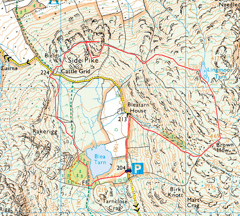
Striding Edge

A photo diary of Lake District fell walks

  • Walks
  • Fells
    • Wainwrights
      • Eastern Fells
      • Far Eastern Fells
      • Central Fells
      • Southern Fells
      • Northern Fells
      • North Western Fells
      • Western Fells
      • Outlying Fells
    • Birketts
  • Dogs
  • Love The Lakes
  • Contact

Brock Barrow

Walked on 05/04/2013

Start point: High Nibthwaite (SD 294 897)

Brock Barrow (OF) from High Nibthwaite

Distance: 1.5 miles     Total Ascent: 175 metres     Time Taken: 40 minutes     Start Time: 17:25

Weather: Cool. 5oC

Casper enjoyed it so much the other day I thought I’d give him the opportunity of another jaunt to a small fell, it was good to have him back although nothing has changed – he is still officially retired unfortunately.

01 East of Coniston

P4052594

High Nibthwaite and Beacon Fell.

P4052595

Over Allan Tarn to Blawith Knott.

P4052597

Brock Barrow.

P4052602

There's still life in the old dog yet.

P4052608_09_10_fused

The Coniston fells from Brock Barrow.

P4052614_5_6_tonemapped

A burst of sunshine over the Crake Valley.

P4052621

Coniston Water and fells.

P4052623

Old pals.

P4052632_3_4_tonemapped

Brock Barrow.

P4052641

The second summit ahead, Wetherlam beyond.

P4052651

The call of the wild.

P4052657

Time for a swim (for Casper and Dougal, not me I hasten to add!) down at Nibthwaite.

P4052658

The Old Man at the head of Coniston Water.

P4052664_5_6_tonemapped

He's keeping a watchful eye on proceedings.

Blawith Knott

Walked on 03/04/2013

Start point: Woodland Fell road (SD 256 879)

Blawith Knott (OF) from the Woodland Fell road

Start Time: 13:40     Weather: Cold wind but sunny. 8oC

Time for a quick walk up to Blawith Knott with Connie, Casper and Dougal today. The wind was biting up there but it was nice to have the company and a fellwalking reunion.

P4032516

Giant's Grave and snowdrift.

P4032524

On the climb.

P4032534-Edit

A panoramic view from Blawith Knott.

P4032543

StridingEdge.net reunion - Connie, Dougal and Casper.

P4032561

The view over Beacon Fell to the north east.

P4032563_4_5_tonemapped

The Coniston fells HDR.

P4032569

Casper - good to be back.

P4032576_7_8_tonemapped

The Duddon Estuary.

P4032582_3_4_tonemapped

Black Combe from Blawith Knott.

P4032587

It was quite windy up here today and that made it feel pretty cold.

P4032592

Blawith Knott from the bottom.

The Langdales

Walked on 25/03/2013

Start point: New Dungeon Ghyll Car Park (NY 295 064)

New Dungeon Ghyll – Stickle Tarn –Harrison Stickle – Dungeon Ghyll – New Dungeon Ghyll

Distance: 2.8 miles     Total Ascent: 635 metres    Time Taken: 3 hours     Start Time: 09:50

Weather: Freezing cold wind, deep snow drifts. 2oC

The snow in Cumbria has been well documented with plenty being dumped on the coast – inland there is still a lot around but the roads are mainly clear. Up on high, the strong winds have made the snow drifts very deep – waist deep in many places today.

01 Harrison Stickle

P3252277

It was cold in Great Langdale first thing this morning.

P3252280

At the foot of the climb to Stickle Tarn, at least there was a glimmer of blue sky.

P3252281

On the frozen path.

P3252283

Looking back down and across to Lingmoor Fell with frequent snow showers blowing in.

P3252286

Crossing Stickle Ghyll...under the snow somewhere!

P3252295

Harrison Stickle across part frozen Stickle Tarn.

P3252298

Looking across Lingmoor and the Coniston fells.

P3252299

I had in mind to climb Pavey Ark by the North Rake but you can see here how much snow is around the tarn where the path normally is. All that lovely white snow was knee to waist deep so I headed up to the higher ground (to the right in this photo) but even that was tough going along the undulations so I gave it up as a bad job thinking the North Rake would be full of snow as well. One chap and then a couple went that way - fair play to them, they did make it across as I could see them later on from up on high but for me the risks outweighed the benefits of going that way today.

P3252301

Fell and sky.

P3252303

Plan B was to climb Harrison Stickle up the west face - you can see the path heading diagonally right upwards, below the crags. As it turned out, I didn't follow that path either as it was also deep with snow! I climbed the gully directly to the right of the smaller second dark area.

P3252304

The snow picks out the line of Jack's Rake on Pavey Ark running from bottom right diagonally across to the left.

P3252316

A view of Easy Gully on Pavey Ark.

P3252323

Stickle Tarn from the climb.

P3252332

Climbing the gully and the equipment required to get there. There was a fierce wind blowing as I reached the top.

P3252335

A change of tack was required here - the usual path goes through the gap below the summit which is full of snow in this photo so I ended up climbing the north face instead - straight up to the right in this photo.

P3252337

Great Langdale from Harrison Stickle.

P3252346

Dougal, aka the windometer, accurately reflects conditions on the top.

P3252352

A fabulous view over Lingmoor Fell and Blea Tarn but there was a wild, wild wind up here.

P3252353

The Coniston fells.

P3252357-Edit

Big Pike o' Stickle and Little Pike o' Dougal from the descent.

P3252362

A splash of colour looking back up.

P3252365

Loft Crag.

P3252366

Dungeon Ghyll. From here, things got more than a little interesting and great care and caution was required. I would not recommend going this way until conditions abate - there were deep drifts of snow and great layered slabs along the path and I must admit the thought of an avalanche focussed my mind on the descent.

P3252372

Past the worst bit and descending towards Pike Howe.

P3252375

Still windy looking up to blue skies above Harrison Stickle.

P3252380

Lingmoor Fell.

P3252386

Great Langdale.

P3252388

Side Pike.

P3252394

Winter Langdale Pikes.

Catbells

Walked on 13/03/2013

Start point: Hawes End (NY 247 212)

Hawes End – Skelgill Bank – Catbells – Hause Gate – Allerdale Ramble – Hawes End

Distance: 3.7 miles     Total Ascent: 451 metres     Time Taken: 1 hour 30 minutes     Start Time: 10:00

Weather: Cold and clear. 2oC

What a beautiful day for a short walk up to Catbells, I would love to have continued and done the Newlands Round today but any walk is better than none. There were views for miles today which was accompanied by a sometimes bracing wind.

01 Catbells

P3131989

There was a fine view across Windermere to the Langdales today.

P3132000_1_2_tonemapped

Close up.

P3132014

Blencathra across Derwent Water at the foot of the climb to Catbells.

P3132015-Edit

A panoramic view.

P3132017

Causey Pike.

P3132020

What a beautiful morning looking across Derwent Water.

P3132038

Yes Dougal, I am hurrying up.

P3132039

Skiddaw.

P3132041-Edit

A panoramic view. Select on the image to see a larger version.

P3132049

The twin peaks of Skelgill Bank and Catbells.

P3132061_2_3_fused-Edit-Edit

A panoramic of the Newlands Valley. Select on the image to see a larger version.

P3132070

Bass Lake and Swinside.

P3132072

The Vale of Keswick.

P3132076

The path to Catbells from Skelgill Bank.

P3132079

A grand climb.

P3132084

The view from the top.

P3132086

Newlands from the summit.

P3132090-Edit-Edit

A panoramic view from Catbells. Select on the image to see a larger version.

P3132106-Edit

Hindscarth and Robinson.

P3132109

Little Town below.

P3132126

The lion has moved from Trafalgar Square.

P3132130

At Hause Gate.

P3132139

Blencathra looming large.

P3132155-Edit-Edit

A panorama from the Allerdale Ramble path - it is starting to cloud over now.

P3132164

I like the way Keswick is picked out in the sunlight in this mono shot. Talking of mono shots...I have had this photo printed on to some huge 1500mm x 500mm top quality canvases and it looks fantastic. E-mail me if you fancy one (select on it to see a larger version)...

P3132164a

Silver How, Grasmere

Walked on 04/03/2013

Start point: Grasmere Church (NY 336 073)

Grasmere – Allan Bank – Silver How – Kelbarrow – Grasmere

Distance: 2.75 miles     Total Ascent: 325 metres     Time Taken: 1 hour 15 minutes     Start Time: 10:50

Weather: Murky and misty. 4oC

It was a murky morning, the sun was ever threatening and did indeed come out much later (i.e. when I went home!). This is a nice enough walk though and there seemed to be one or two out and about enjoying the fresh air.

01 Silver How

P3041937-Edit

A Grasmere panorama, from Allan Bank.

P3041939

Helm Crag.

P3041943

Murky and misty looking across to Heron Pike.

P3041944

Climbing higher.

P3041947

Grasmere and Loughrigg.

P3041950

Caught in the act!

P3041963-Edit

The path to Silver How.

P3041965

No Langdales view from Silver How summit.

P3041967

Dougal, the fell dog.

P3041975

Grasmere and Rydal Water.

P3041976

Dougal waits for me, surveying his kingdom.

P3041980

The Monarch of the Glen.

Blencathra via Sharp Edge

Walked on 27/02/2013

Start point: Scales (NY 349 272)

Scales – Sharp Edge – Blencathra (Atkinson Pike – Hallsfell Top – Scales Fell) – Scales

Distance: 4.5 miles     Total Ascent: 642 metres    Time Taken: 2 hours 45 minutes     Start Time: 08:10

Weather: Sunny, warm in the sunshine. 8°C

Yet another beautiful day here with sunny blue skies all around. Today we climbed Sharp Edge up to Blencathra, the reminder that it was still winter was on the north face of the edge where the ice was treacherous to the unwary.

Warning: Do not attempt Sharp Edge in winter conditions unless you know what you are doing. Never take a dog that way.

01 Sharp Edge.jpg

P2271579

Moon setting over the north western fells.

P2271627

Derwent Water at dawn...it was so cold down here, -7C, my fingers were really numb even with gloves on.

P2271656-Edit

Catbells. Onwards and upwards...

P2271668

Mousthwaite Comb.

P2271672

Looking back down and across to Clough Head on a gorgeous day.

P2271678-Edit

Sharp Edge ahead.

P2271705

Scales Tarn.

P2271709

Climbing towards Sharp Edge.

P2271712

At the foot of the climb.

P2271721

On Sharp Edge. The north face (to the right in this photo) was icy and treacherous.

P2271726-Edit

A panoramic view climbing the edge.

P2271729

The 'awkward place'.

P2271731

Looking down Razor Edge.

P2271739

Made it! The view from the top.

P2271748

Skiddaw from Atkinson Pike.

P2271752

A beautiful day up on the top of Blencathra.

P2271754

The White Cross looking to the Coledale fells.

P2271759

The frozen summit tarn.

P2271764-Edit

Dougal - walking on water?

P2271767

Blencathra.

P2271774

Dougal on the summit of Blencathra.

P2271778

The Vale of Keswick and beyond.

P2271781

Looking across Derwent Water and down on Love the Lakes, Keswick.

P2271782

The Coledale fells across Gategill Fell.

P2271807

Looking back from the descent.

P2271810

Sharp Edge in profile.

P2271826

Blencathra with the saddle in view from Scales Fell.

P2271837

Fabulous.

P2271855-Edit

Castlerigg Stone Circle panoramic, Blencathra beyond.

Hard Knott

Walked on 25/02/2013

Start point: Hardknott Pass summit (NY 230 014)

Hardknott Pass – Border End – Eskdale Needle – Hard Knott – Hardknott Pass

Distance: 1.6 miles     Total Ascent: 188 metres     Time Taken: 1 hour     Start Time: 14:40

Weather: Sunny. 8°C

Sunshine was all around today and it was really quite warm and pleasant too. Today I was with Dougal alone, even on this relatively short and easy walk, as I have retired Casper from fell walking. His age has caught up with him now and he can no longer manage to wander the fells with us – sad but true. He will be retiring in comfort though with the knowledge he has led a great life getting to places other dogs can only dream of; we have spent many happy hours together. In the future I think he will be joining the Love the Lakes team as Chief Shop Dog so I think he will be regaling all and sundry with his tales from the fells should he be asked!


01 Hard Knott.jpg

P2251456

Wrynose Pass.

P2251457-Edit

A wider view looking across the Duddon Valley to the Coniston fells.

P2251467

Border End.

P2251468

What a beautiful day and warm enough for shirt sleeves (for a while anyway as once over the top of Border End there was an icy wind blowing down the valley so fleece, hat and gloves were required!).

P2251472

The head of Eskdale from frozen Border End.

P2251474

...and again, from further along.

P2251478-Edit

Looking along the Eskdale Valley into the bright sunshine.

P2251499

Dougal checks out the fabulous view...or is he looking for Casper?

P2251506-Edit

A panoramic view of the Scafells from Border End. Select on the image to see a larger version.

P2251514

Esk Pike and Bowfell, Eskdale Needle at the bottom of the photo.

P2251516-Edit

A wider panorama.

P2251521

Slight Side and Scafell.

P2251527

The approach to Eskdale Needle.

P2251530

The Needle is in a fantastic situation overlooking Upper Eskdale and The Scafells.

P2251536

Eskdale Needle from the south.

P2251541

The Steeple.

P2251543

Climbing to Hard Knott.

P2251547

Scafell Pike, Broad Crag and Ill Crag with the lower subsidiary summit of Scafell Pike, Pen, foremost.

P2251548

Esk Pike.

P2251551

I think those clouds look great but have a look at the photos to see how quickly they change, they are different in every one!

P2251559

Hard Knott summit.

P2251564

As above, so below looking to Grey Friar across a frozen pool.

P2251567-Edit

Ulpha Fell (Little Stand) along the Duddon Valley.

P2251573

Spring has sprung in Dunnerdale.

Middle Fell

Walked on 22/02/2013

Start point: Greendale (NY 144 056)

Greendale – Middle Fell – Greendale Tarn – Greendale Gill – Greendale

Distance: 3.2 miles     Total Ascent: 525 metres     Time Taken: 1 hour 45 minutes     Start Time: 09:15

Weather: Cold and overcast. 2°C

It was so cold up there today – to the bone in fact – and not a day for hanging around for too long. Wasdale though, as ever, was beautiful.

Middle Fell.JPG

P2221324

Wasdale.

P2221327_8_9

A mono version.

P2221331

The Scafells from Greendale.

P2221333

Greendale Gill.

P2221356

Buckbarrow.

P2221358

The summit of Middle Fell.

P2221361_2_3

The Scafells.

P2221367

Kirk Fell, Great Gable and the Scafells over Yewbarrow.

P2221373

Dougal and Casper on Middle Fell.

P2221380

It was cold and icy up here.

P2221382

The fell dog in his natural environment, Haycock beyond.

P2221385

Seatallan and part frozen Greendale Tarn.

P2221397

I can hear voices down below.

P2221401-Edit

Greendale Tarn.

P2221403

Icy Greendale Gill.

P2221406

I took a wander over by Joss's cairn on the side of Buckbarrow, here looking to Middle Fell.

P2221412

The Screes and Wast Water.

P2221413

Heading back down to Greendale.

P2221417-Edit

The Screes panoramic.

P2221422

Greendale Gill.


Skiddaw

Walked on 19/02/2013

Start point: Gale Road End (NY 281 253)

Gale Road End – Skiddaw Lesser Man – Skiddaw Little Man – Skiddaw – Jenkin Hill – Lonscale Fell – Lonscale Pike – Latrigg – Gale Road End

Distance: 8.5 miles     Total Ascent: 860 metres     Time Taken: 4 hours 30 minutes     Start Time: 07:00

Weather: Beautiful sunshine above the haze. 5°C

I was up early again today to catch the sunrise and it was well worth it to see the beautiful rising sun across a temperature inversion. Once above the haze layer the air was very clear – a fantastic and memorable day to be out on the fells.

01 Skiddaw.JPG

P2191021

The Hawell Monument, pre-dawn.

P2191032

The Coledale fells and a pinky pre-sunrise sky.

P2191039

The sun appears on the horizon.

P2191045

A sunny glow above the haze.

P2191058

A warming glow.

P2191074

Climbing higher, a fabulous sunrise and inversion to the east.

P2191077

Skiddaw Little Man in the dawn glow.

P2191084-Edit

Blencathra and the view to the east.

P2191107_8_9

Skiddaw Lesser Man.

P2191115

Skiddaw Little Man looking down to Lesser and the Helvellyn massif beyond.

P2191129

Dougally Doo...no Casper today so you are on your own lad.

P2191131

Clear skies now above the layer of haze.

P2191139

The Ullock Pike ridge.

P2191139a

Catbells to Scafells.

P2191139b-Edit

Mono layers.

P2191159

On the summit plateau looking down on Little Man.

P2191163

The Ullock Pike ridge and Bassenthwaite Lake, beyond there is a heavy covering of cloud across the sea.

P2191180

What a fabulous day.

P2191181

The air was very clear and hardly a breath of wind today.

P2191190

Well worth taking a photo or two.

P2191196-Edit

The back o' Skidda.

P2191202

Skiddaw summit.

P2191210

The Lakeland giants across Derwent Water.

P2191220

Descending to Lonscale Fell.

P2191229

The mist is clearing a bit as the sun warms up.

P2191237-Edit

Warmer, but not that warm.

P2191241

Skiddaw from Lonscale Fell.

P2191248-Edit

A panorama of loveliness.

P2191254

Blencathra from Lonscale Pike.

P2191262-Edit

The view from Lonscale Pike.

P2191271

The steep descent.

P2191276

Following the track back toward Latrigg, the green hill on the left.

P2191299-Edit-2

The Coledale fells from Latrigg.

P2191302-Edit

A.W?

P2191319-Edit

Skiddaw from Latrigg.


Gummer’s How

Walked on 12/02/2013

Start point: Gummer’s How Car Park (SD 390 877)

Gummer’s How Car Park – Gummer’s How (OF) – Gummer’s How Car Park

Distance: 1.2 miles     Total Ascent: 150 metres     Time Taken: 1 hour     Start Time: 10:50

Weather: Cold and grey. 2°C

It was cold and grey this morning with no signs of any brighter weather when we set off to Gummer’s How. There were plenty of families up there agian today enjoying the fresh air – and the invasion of cows!

IMG_0030

OLYMPUS DIGITAL CAMERA

Lakeside on a grey day from the start of the path to Gummer's How.

OLYMPUS DIGITAL CAMERA

Roadblock - easy to get past in your own, not easy with two furry cow magnets in tow.

OLYMPUS DIGITAL CAMERA

Phew, made it! Connie checks out the view.

OLYMPUS DIGITAL CAMERA

I spy people.

OLYMPUS DIGITAL CAMERA

Connie, aged 12.

OLYMPUS DIGITAL CAMERA

There is still a bit of snow and ice lingering on the northern side.

OLYMPUS DIGITAL CAMERA

Windermere.

OLYMPUS DIGITAL CAMERA

Connie, Casper and Dougal.

OLYMPUS DIGITAL CAMERA

A glimpse of the sun.

Coniston Old Man

Walked on 08/02/2013

Walna Scar road (SD 289 970)

Walna Scar car park – Boo Tarn – The Old Man of Coniston – Brim Fell – Brim Fell Rake – Low Water – Below Beck Fells – Walna Scar car park

Distance: 4.3 miles     Total Ascent: 630 metres     Time Taken: 2 hours 30 minutes     Start Time: 09:30

Weather: Cold with a strong wind on top. 3°C

The weather turned out much better than I thought it would today – it was a proper winter’s day up on The Old Man, all blue sky and snow, just lovely. That was a good choice Casper lad!

IMG_0042

OLYMPUS DIGITAL CAMERA

The Coniston fells looking good from Torver.

OLYMPUS DIGITAL CAMERA

A spontaneous outbreak of sunshine on the climb to The Old Man.

OLYMPUS DIGITAL CAMERA

Brown Pike in sight. Just after this I stumbled on some ice and my bottle fell out of the side pocket on my rucksack - it was just great to watch it slide down on the ice and snow for 30 metres. Curses were issued.

OLYMPUS DIGITAL CAMERA

Walna Scar and Brown Pike.

OLYMPUS DIGITAL CAMERA

Buck Pike and Dow Crag across The Cove.

OLYMPUS DIGITAL CAMERA

Casper and Dougal hold paws.

OLYMPUS DIGITAL CAMERA

The view over Coniston and Windermere beyond.

OLYMPUS DIGITAL CAMERA

The view over Coniston and Windermere beyond.

OLYMPUS DIGITAL CAMERA

Sunshine and blue sky approaching the summit.

OLYMPUS DIGITAL CAMERA

A fabulous view over Low Water to Wetherlam and beyond from the top.

OLYMPUS DIGITAL CAMERA

A panoramic view from The Old Man of Coniston. Select on the image to see a larger version.

OLYMPUS DIGITAL CAMERA

The summit of The Old Man.

OLYMPUS DIGITAL CAMERA

A lovely winter view of The Scafells.

OLYMPUS DIGITAL CAMERA

It was beautiful up here...

OLYMPUS DIGITAL CAMERA

...beautiful but cold, I should add.

OLYMPUS DIGITAL CAMERA

The boys on the summit.

OLYMPUS DIGITAL CAMERA

The Coniston fells.

OLYMPUS DIGITAL CAMERA

Looking back to the summit cairn.

OLYMPUS DIGITAL CAMERA

Dow Crag and Harter Fell.

OLYMPUS DIGITAL CAMERA

Brim Fell with Bowfell putting in an appearance in the background.

OLYMPUS DIGITAL CAMERA

Old Men?

OLYMPUS DIGITAL CAMERA

Brim Fell.

OLYMPUS DIGITAL CAMERA

A panoramic view from Brim Fell, select on the image to see a larger version.

OLYMPUS DIGITAL CAMERA

Looking across Grey Friar from Brim Fell.

OLYMPUS DIGITAL CAMERA

At the top of Brim Fell Rake.

OLYMPUS DIGITAL CAMERA

Loving it now, it was just a fantastic winter's day up here.

OLYMPUS DIGITAL CAMERA

Blazing a trail down the rake.

OLYMPUS DIGITAL CAMERA

Levers Water, Black Sails and Wetherlam.

OLYMPUS DIGITAL CAMERA

Insurance on the steep descent.

OLYMPUS DIGITAL CAMERA

Low Water and The Old Man from Raven Tor.

OLYMPUS DIGITAL CAMERA

Low Water.

OLYMPUS DIGITAL CAMERA

The descent through the old mine workings.

Grisedale Pike

Walked on 06/02/2013

Start point: Braithwaite (NY 227 237)

Braithwaite – Kinn – Grisedale Pike – Hobcarton Head – Hopegill Head – Sand Hill – Coledale Hause – Coledale – Braithwaite

Distance: 7 miles     Total Ascent: 843 metres     Time Taken: 3 hours 30 minutes     Start Time: 10:15

Weather: Cold with a strong wind. 3°C

With a break in the weather and a bit of sunshine around, Grisedale Pike looked very tempting from Keswick today wearing its best winter coat. The predicted weather as for high winds with a wind chill of -18C and so it turned out in the end – I didn’t fancy the full Coledale round once I had been up high for a while so took the valley route from Coledale Hause. As the old saying goes “Half a Coledale is better than no Coledale at all”! Once again it was just me and young Dougal whilst Casper stayed at home in the warm – sensible boy!

Grisedale Pike

OLYMPUS DIGITAL CAMERA

Before the walk...a wintry view along Windermere from Bowness Bay.

OLYMPUS DIGITAL CAMERA

Skiddaw from Braithwaite.

OLYMPUS DIGITAL CAMERA

A panoramic view of Skiddaw.

OLYMPUS DIGITAL CAMERA

Causey Pike beyond Barrow from the climb to Kinn.

OLYMPUS DIGITAL CAMERA

Cold Coledale.

OLYMPUS DIGITAL CAMERA

Grisedale Pike.

OLYMPUS DIGITAL CAMERA

Dougal checks out the climb.

OLYMPUS DIGITAL CAMERA

Sail in mono.

OLYMPUS DIGITAL CAMERA

Sunshine and cloud.

OLYMPUS DIGITAL CAMERA

Eel Crag and the Coledale Valley.

OLYMPUS DIGITAL CAMERA

The climb to Grisedale Pike up Sleet How...spot the Dougal?!

OLYMPUS DIGITAL CAMERA

Kinn, Skiddaw and the Vale of Keswick.

OLYMPUS DIGITAL CAMERA

Climbers ahead on Sleet How.

OLYMPUS DIGITAL CAMERA

Looking back down from Sleet How.

OLYMPUS DIGITAL CAMERA

The summit of Grisedale Pike - with a bitter, strong wind, it really was as cold as it looks.

OLYMPUS DIGITAL CAMERA

A winter panorama.

OLYMPUS DIGITAL CAMERA

The view across Outerside and Causey Pike.

OLYMPUS DIGITAL CAMERA

Grasmoor beyond Hobcarton Head.

OLYMPUS DIGITAL CAMERA

Dougal surveys the head of Coledale.

OLYMPUS DIGITAL CAMERA

On the descent, first heading for Hobcarton Head then Hopegill Head up to the right.

OLYMPUS DIGITAL CAMERA

Lovely winter scenery but oh-so cold.

OLYMPUS DIGITAL CAMERA

Walkers on Hobcarton Head give some scale to the scene.

OLYMPUS DIGITAL CAMERA

Looking back to Grisedale Pike, Skiddaw beyond from Hobcarton Head.

OLYMPUS DIGITAL CAMERA

Grasmoor.

OLYMPUS DIGITAL CAMERA

Hopegill Head and Ladyside Pike.

OLYMPUS DIGITAL CAMERA

Grisedale Pike from the climb to Hopegill Head.

OLYMPUS DIGITAL CAMERA

Whiteside and a glimpse of Crummock Water from Hopegill Head summit.

OLYMPUS DIGITAL CAMERA

Wandope.

OLYMPUS DIGITAL CAMERA

The cloud is starting to cover the fells to the south and east now.

OLYMPUS DIGITAL CAMERA

Eel Crag from Sand Hill.

OLYMPUS DIGITAL CAMERA

Skiddaw and Blencathra along the Coledale Valley.

OLYMPUS DIGITAL CAMERA

Force Crag mine.

Black Fell

Walked on 30/01/2013

Start point: Knipe Fold (SD 391 994)

Black Fell from Knipe Fold

Distance: 3.4 miles     Total Ascent: 215 metres     Time Taken: 1 hour 15 minutes     Start Time: 09:00

Weather: Strong wind. 7oC

There has been little chance for me to get out on the fells over this last couple of weeks but today there was an opportunity but the weather forecast seemed to scupper any plans I had. Today’s mission was to beat the forecast rain, hail, thunder…

01 Black-Fell

P1309825

The boys are back in town! Heading along the lane from Knipe Fold.

P1309830

Black Crag, the summit of Black Fell to the left and the south east cairn to the right.

P1309833

Looks a bit dull over the Coniston fells.

P1309838

Windermere.

P1309840

Esthwaite Water over the south east cairn.

P1309848

It was a little breezy today.

P1309858

Eye, eye Dougal.

P1309863

Black Crag on Black Fell.

P1309864-Edit

A wider view.

P1309868

Looking across the wall towards Ambleside and beyond.

P1309874

Lingmoor Fell with the Langdale Pikes under the cloud somewhere.

P1309876

The Fairfield Horseshoe.

P1309886

Coniston Water and Tarn Hows visible across the trig. column.

P1309888

Esthwaite Water.

P1309892-Edit-Edit

A bleak house.

P1309896-Edit

A Windermere panorama from the cairn.

P1309898

Looking back up to the column.

P1309904

Wetherlam, clear of cloud for now.

P1309910-Edit

Knipe Fold contre-jour.

Wetherlam, Steel Edge and Wetherlam Edge

Walked on 16/01/2013

Start point: Tilberthwaite car park (NY 306 010)

Tilberthwaite – Steel Edge – Wetherlam – Wetherlam Edge – Birk Fell Man on Birk Fell – Tilberthwaite Gill – Tilberthwaite

Distance: 4.2 miles     Total Ascent: 648 metres     Time Taken: 3 hours 30 minutes     Start Time: 09:25

Weather: Freezing. -1oC

There is plenty of snow around to quite a low level at the moment and the valley roads are treacherously icy in places. I left Casper at home today (by the fire, of course!) as he feels the cold these days (he is no spring chicken) and with young Dougal by my side climbed to Wetherlam via Steel Edge and descended by way of treacherous Wetherlam Edge. It was a bit of a monochrome day with no contrast between the sky and the snow covered land making the task of getting decent photos even harder than usual!

01 Wetherlam

P1169639

The Coniston Fells from Torver.

P1169642

It was a freezing cold day, here looking back over Tilberthwaite.

P1169644

Wetherlam across Tilberthwaite Gill.

P1169645

Tilberthwaite, the winter wonderland.

P1169656

Winter sky over Morecambe Bay.

P1169660

The way to the top of Wetherlam via Steel Edge.

P1169662-Edit

Steel Edge. Crampons were required to climb it this morning.

P1169670

Looking back down Steel Edge.

P1169675_6_7

The view to Coniston Water.

P1169678

The Old Man (and the young!) and Brim Fell.

P1169680-Edit-Edit

A panoramic view of the Coniston fells, select on the image to see a larger version.

P1169698-Edit

The Langdale Pikes from the summit of Wetherlam.

P1169707

Dougal snow-beard.

P1169719

The descent of Wetherlam Edge was quite hairy in places - I had crampons on at the top but there wasn't really enough snow for them so I ended up with spikes on and an ice-axe for this one.

P1169722-Edit

Mist forming in Greenburn below on the descent of Wetherlam Edge.

P1169723

Crinkle Crags, Bowfell and Pike o' Blisco with Greenburn Reservoir below.

P1169725

A distant view across freezing Lakeland to Helvellyn and Fairfield.

P1169729

Looking back up Wetherlam Edge.

P1169732-Edit

Wetherlam.

P1169736

The Langdales from Birk Fell.

P1169742

Passing the Larch trees in Tilberthwaite.

P1169743

Wetherlam Edge.

P1169746

Steel Edge. Select on the image to see an overlaid route.

The Scafells

Walked on 10/01/2013

Start point: Brackenclose (NY 182 074)

Brackenclose – Brown Tongue – Scafell Pike – Ill Crag – Broad Crag – Great End (and return) – Mickledore – Hollow Stones – Brackenclose

Distance: 7.5 miles     Total Ascent: 1247 metres     Time Taken: 6 hours     Start Time: 06:45

Weather: Sunny above the clouds. 3oC

With the ridge of high pressure sitting over the Lake District and the persistent fog at lower levels there was a very good chance there would be a temperature inversion today which fortunately proved to be correct. I set off early from Brackenclose to try and catch the sunrise from the roof of England and I am glad I did, it was a fantastic morning to have the highest peaks in the land all to myself with some stunning views.

01 The Scafells

P1109298

Just made it in time - sunrise from the summit of Scafell Pike.

P1109300

What a beautiful morning with a big temperature inversion sitting over most of the Lake District.

P1109301

This was interesting to watch, the cloud is pouring over Sty Head into the valley between Great Gable and Great End. In the distance are Skiddaw and Blencathra.

P1109303

Summit view.

P1109308-Edit

A panoramic of the cloud inversion. Select on the image to see a larger version.

P1109312

Red sky at the trig. column and an inversion over Buttermere in the distance.

P1109315

Scafell Pike summit positively glowing, from the southern cairn.

P1109319

Mickledore and Broad Stand.

P1109319-Edit

Scafell panorama.

P1109326

Looking along Upper Eskdale to Caw, Harter Fell and Green Crag.

P1109327

Black Combe and Whitfell above the sea of cloud.

P1109345

Glowing sun.

P1109347

The Grasmoor and Dale Head groups of fells beyond the Gables.

P1109350

Far reaching tentacles.

P1109356

The descent from Scafell Pike to Broad Crag, Ill Crag to the right and Great End.

P1109368

Scafell Pike from Ill Crag.

P1109368-Edit

Scafell Pike and Ill Crag (and Casper!) from Broad Crag.

P1109370

Sunny on Great End.

P1109386

The view to Skiddaw and Blencathra over Sprinkling Tarn.

P1109388

Skiddaw with High Spy central with Seathwaite Fell summit at the very bottom of this photo.

P1109401-Edit

A panoramic from Great End. Select on the image to see a larger version.

P1109405

Looking across Rossett Gill to Great Langdale.

P1109410

Dougal and Casper are loving it.

P1109420

Looking back along the Scafells from Great End.

P1109429

Ocean of dreams - Caw and Harter Fell.

P1109431

A fabulous view on a fabulous day.

P1109444

Lowly Stickle Pike has put in appearance beyond Harter Fell.

P1109447

Crossing the Broad Crag col, the cloud was pouring into Upper Eskdale.

P1109448

Another chance to sit and watch with wonder, the cloud pouring across Pen then floating up towards me.

P1109459

Back on Scafell Pike with sunshine and loveliness all around.

P1109464

Descending to Mickledore.

P1109467

This icy descent is not for the faint hearted.

P1109469

Pulpit Rock.

P1109472

Descending to Wasdale.

P1109479-Edit-2

Yewbarrow.

P1109482

Wast Water. On the way home, I had to see what the view was like from Stickle Pike looking the other way...

P1109517

...unfortunately conditions had changed a little but there was still a nice inversion over the Duddon Valley with the Scafell in view top left.

P1109518-Edit

Caw.

Holme Fell

Walked on 07/01/2013

Start point: Hodge Close (NY 315 016)

Holme Fell from Hodge Close

Distance: 1.7 miles     Total Ascent: 165 metres     Time Taken: 1 hour 15 minutes     Start Time: 10:50

Weather: Murky but dry. 8oC

The first walk of 2013 and the weather is as it was last time I was out – dark and murky. I can’t grumble, at least it was dry and the air was fresh although taking photos when it is like this is not the easiest thing as it is just so dark.

Note: This walk marks 10 years since I took the first photos on this site on the Langdales on 7th January 2003 (although the website didn’t start until a year later). What a journey it has been, I hope you will stay with us for the next 10 years!

01 Holme Fell

P1079170

Hodge Close Quarry.

P1079172

Holme Fell ahead...somewhere.

P1079183-Edit-2

Misty trees.

P1079184-Edit

Fleeting views from the boggy climb.

P1079188

Clearing mist over Tilberthwaite.

P1079194

Dougal and Casper on top of Holme Fell.

P1079196

Ivy Crag.

P1079198

Ivy Crag.

P1079204

There are fell walking cows over there!

P1079215_6_7_6_7

Reservoir.

P1079221_2_3

Mono reflections.

P1079224

Wetherlam makes the briefest of appearances.

P1079226-Edit

Swansong on Yew Tree Tarn.

Orrest Head

Walked on 19/12/2012

Start point: Windermere (SD 414 987)

Orrest Head (OF) from Windermere

Distance: 1.3 miles     Total Ascent: 105 metres    Time Taken: 30 minutes     Start Time: 09:20

Weather: Cold wind, overcast. 5ºC

Just enough time for a quick walk up to Orrest Head this morning, I thought it would be wise to get up there as early as possible before the predicted high winds and accompanying rain. There was an icy blast up there to remind us that it is still mid-winter…

OLYMPUS DIGITAL CAMERA

Today was one of those grey winter days (the dark days) when it never seems to get light so this walk was pretty much in the gloom with no distant views - this one is looking across Windermere village to Windermere.

OLYMPUS DIGITAL CAMERA

A panoramic view - you don't have to get so far from the road to see a good length of the lake. It was no wonder the Victorians decided this would be a good place for a tourist stopping place.

OLYMPUS DIGITAL CAMERA

Climbing higher.

OLYMPUS DIGITAL CAMERA

A panoramic of the top of Orrest Head.

OLYMPUS DIGITAL CAMERA

The Far Eastern fells from the top.

OLYMPUS DIGITAL CAMERA

Mono view.

OLYMPUS DIGITAL CAMERA

There is a new view indicator courtesy of The Wainwright Society and Windermere Town Council and what a good job they have made of it with a lovely piece of etched slate.

OLYMPUS DIGITAL CAMERA

Windblown Dougal and Casper on the top, it was pretty cold up here.

OLYMPUS DIGITAL CAMERA

Looking across to School Knott.

OLYMPUS DIGITAL CAMERA

Dougal checks out the northern reaches of Windermere.

OLYMPUS DIGITAL CAMERA

The return to Windermere.

Wansfell

Walked on 10/12/2012

Start point: Troutbeck (NY 409 032)

Troutbeck – Nanny Lane – The Hundreds – Wansfell – Wansfell Pike – Nanny Lane – Troutbeck

Distance: 3.7 miles     Total Ascent: 350 metres     Time Taken: 1 hour 30 minutes     Start Time: 09:50

Weather: Sunny with snow showers. 4ºC

More cold weather today and it was sunny around the fringes of the Lake District but many of the higher tops were shrouded in cloud; cloud that looked heavily snow laden. Even lowly Wansfell had a good few snow flurries blowing across whilst I was up there but in between there were some decent views.

OLYMPUS DIGITAL CAMERA

At the start of Nanny Lane.

OLYMPUS DIGITAL CAMERA

Ill Bell across the fields.

OLYMPUS DIGITAL CAMERA

Following the walls...

OLYMPUS DIGITAL CAMERA

...right to the end.

OLYMPUS DIGITAL CAMERA

Sunshine and snow clouds.

OLYMPUS DIGITAL CAMERA

On the summit of Wansfell.

OLYMPUS DIGITAL CAMERA

Windermere and Wansfell.

OLYMPUS DIGITAL CAMERA

Caught in the sun - Dougal and Casper.

OLYMPUS DIGITAL CAMERA

It's behind you! A snow storm blowing in.

OLYMPUS DIGITAL CAMERA

Looking across Ambleside....all was good until I realised I had dropped a glove so made a return to Wansfell summit. Luckily it hadn't blown away, so not too bad.

OLYMPUS DIGITAL CAMERA

Wansfell Pike ahead.

OLYMPUS DIGITAL CAMERA

Kirkstone Pass.

OLYMPUS DIGITAL CAMERA

Looking back to Wansfell.

OLYMPUS DIGITAL CAMERA

Across Ambleside, Loughrigg and Lingmoor to Crinkle Crags, Bowfell and the Langdale Pikes.

OLYMPUS DIGITAL CAMERA

A panoramic view from Wansfell Pike. Select on the image to see a larger version.

OLYMPUS DIGITAL CAMERA

Close up on Bowfell and The Langdales.

OLYMPUS DIGITAL CAMERA

Crinkle Crags and Bowfell.

OLYMPUS DIGITAL CAMERA

Mono Windermere in the bright sunshine.

OLYMPUS DIGITAL CAMERA

Heading back to Troutbeck.

Helvellyn

Walked on 05/12/2012

Start point: Wythburn (NY 324 136)

Wythburn – Birk Side – High Crag – Nethermost Pike – Helvellyn – Nethermost Pike – Dollywaggon Pike – Wythburn

Distance: 5.8 miles    Total Ascent: 924 metres     Time Taken: 3 hours 30 minutes     Start Time: 06:40

Weather: Freezing, some cloud and a cold wind. 0ºC

I seem to be following a bit of a pattern here with heading out early, chasing the sunrise but I find it is well worth it. Today’s views were just jaw dropping with the sun lighting up the fells with some fabulous colours. The wind was very strong making it feel like a bit of an Arctic expedition at times and I was well layered up for this one.

Helvellyn

Helvellyn Route Map

OLYMPUS DIGITAL CAMERA

First light, the moon still high in the sky.

OLYMPUS DIGITAL CAMERA

Climbing to High Crag, trying to make it in time for the sun coming over the horizon.

OLYMPUS DIGITAL CAMERA

Made it, and well worth the effort it was too.

OLYMPUS DIGITAL CAMERA

Big cornice lit up with a lovely pink hue by the early morning sun.

OLYMPUS DIGITAL CAMERA

The Coniston fells.

OLYMPUS DIGITAL CAMERA

Looking back to High Crag.

OLYMPUS DIGITAL CAMERA

There was a strong, cold wind blowing up here as Casper and Dougal will tell you.

OLYMPUS DIGITAL CAMERA

A jaw dropping sunrise, just fabulous.

OLYMPUS DIGITAL CAMERA

A panoramic view from Nethermost Pike, select on the image to see a larger version.

OLYMPUS DIGITAL CAMERA

Pink snow looking to Helvellyn from Nethermost Pike.

OLYMPUS DIGITAL CAMERA

Catstycam and Striding Edge.

OLYMPUS DIGITAL CAMERA

Cornice on Helvellyn and the climb to the cross shelter. Time to get the crampons on from here, there was snow on ice and it was quite treacherous in places.

OLYMPUS DIGITAL CAMERA

My original intention was to drop down and cross Striding Edge, however I reckoned it would be a little tricky today especially with this wind so I gave it a miss.

OLYMPUS DIGITAL CAMERA

It has calmed down a little now looking down on Striding Edge.

OLYMPUS DIGITAL CAMERA

The view from Helvellyn. Select on the image to see a larger version.

OLYMPUS DIGITAL CAMERA

A brand new white coat for Catstycam.

OLYMPUS DIGITAL CAMERA

The cross shelter.

OLYMPUS DIGITAL CAMERA

The summit of Helvellyn.

OLYMPUS DIGITAL CAMERA

Spindrift on Helvellyn.

OLYMPUS DIGITAL CAMERA

It was quite fierce at times!

OLYMPUS DIGITAL CAMERA

Striding Edge from the summit.

OLYMPUS DIGITAL CAMERA

Swirral Edge.

OLYMPUS DIGITAL CAMERA

Swirral Edge to Catstycam.

OLYMPUS DIGITAL CAMERA

Heading back across the summit plateau.

OLYMPUS DIGITAL CAMERA

Snowbeard has a piece of my banana!

OLYMPUS DIGITAL CAMERA

Having a quick coffee in the cross shelter Dougal decided he would become the King of Helvellyn. People often ask how Dougal and Casper manage in the snow but remember, they are fell bred and the fells are a Beardies home turf.

OLYMPUS DIGITAL CAMERA

At the Gough Memorial.

OLYMPUS DIGITAL CAMERA

Of course, I can't resist another view of Striding Edge!

OLYMPUS DIGITAL CAMERA

A panoramic view of Striding Edge. Select on the image to see a larger version.

OLYMPUS DIGITAL CAMERA

Blue skies now the sun is up but it still oh so cold.

OLYMPUS DIGITAL CAMERA

The view to the west from Nethermost Pike.

OLYMPUS DIGITAL CAMERA

Seat Sandal.

OLYMPUS DIGITAL CAMERA

Grisedale, frozen Hard Tarn below.

OLYMPUS DIGITAL CAMERA

Sun, shadows, cloud and cornice.

OLYMPUS DIGITAL CAMERA

Fairfield.

OLYMPUS DIGITAL CAMERA

The summit of Dollywaggon Pike.

OLYMPUS DIGITAL CAMERA

A lovely, windblown view.

OLYMPUS DIGITAL CAMERA

Great Gable to Pillar across Ullscarf.

OLYMPUS DIGITAL CAMERA

Bowfell to the Scafells.

OLYMPUS DIGITAL CAMERA

A panorama from Dollywaggon Pike. Select on the image to see a larger version.

OLYMPUS DIGITAL CAMERA

From the descent of Dollywaggon Pike.

OLYMPUS DIGITAL CAMERA

At the ruined sheepfold on the descent - I managed to lose the path here, I couldn't see it anywhere!

OLYMPUS DIGITAL CAMERA

This will do though, Thirlmere and Skiddaw from the descent.

OLYMPUS DIGITAL CAMERA

Coniston Sunrise

Walked on 30/11/2012

Start point: Walna Scar road (SD 289 970)

Walna Scar car park – Coniston Old Man – Brim Fell – Goat’s  Hawse – Dow Crag – Buck Pike – Blind Tarn – Walna Scar car park

Distance: 5.3 miles     Total Ascent: 780 metres     Time Taken: 3 hours     Start Time: 07:20

Weather: Freezing, some cloud. 0oC

It has been really cold and clear for the last couple of days so I wanted to get high on a fell to catch a glorious sunrise this morning and I wasn’t disappointed with the one I got – the view from the Old Man was fabulous this morning, one to remember for a while.

Coniston

PB308260

Pre-dawn on the climb to The Old Man and the sun is still below the horizon.

PB308262

Getting lighter as I climb higher, the valleys below are covered in mist.

PB308289

Sunrise, first sight of the sun over the horizon.

PB308295

The view down from the climb.

PB308297

Mono Coniston Water, partially frozen, and Windermere beyond covered in a thick blanket of cloud.

PB308303

Black Combe and Brown Pike glowing in the early sunshine.

PB308307

Morecambe Bay with Heysham Power Station visible looking along cloud covered Coniston Water and the Crake Valley.

PB308309

The full moon over Dow Crag.

PB308310

Martian mountains?

PB308314

Winter Hill on the horizon floating above a sea of orange cloud.

PB308321_stitch

A panoramic view from the summit.

PB308323

The view over Low Water and Levers Water.

PB308327

The sun has risen into cloud now looking across layers of valleys.

PB308328

The Old Man summit view.

PB308333

Silhouetted cairn.

PB308334

No one was around this early (of course!).

PB308350_stitch

The face of Dow Crag - at this point I wasn't sure where I was heading next and seemed to do quite a bit of aimless wandering, watching the conditions unfold to work out the best way to go.

PB308352

The Old Man in mono.

PB308354

The Scafells.

PB308360

There was a fabulous winter sky this morning.

PB308375

Brim Fell summit cairn and The Old Man.

PB308379

Casper surveys his kingdom.

PB308382

Skiddaw, Great Carrs, Swirl How and Blencathra.

PB308383

Scafell and Scafell Pike.

PB308384

Skiddaw.

PB308386

Frozen Brim Fell.

PB308395

Brr, it was cold up here today.

PB308399

Brim Fell summit.

PB308402

Finding a way down.

PB308408

Goat's Water.

PB308419

Dougal and Casper, raring to go!

PB308427

Harter Fell.

PB308430

The view from Dow Crag.

PB308433

Looking back over Goat's Hawse.

PB308438

The frozen Duddon Valley.

PB308442

Dow Crag from Buck Pike.

PB308457

Me and Casperoonals.

PB308459

Blind Tarn.

PB308464

Coniston Old Man across The Cove.

PB308481_2_3_tonemapped

That fiery sky was ever-present today.

PB308488

Sun Dog to the left.

PB308490

Cove Bridge.

  • « Previous Page
  • 1
  • …
  • 7
  • 8
  • 9
  • 10
  • 11
  • …
  • 53
  • Next Page »

Walking Diary

  • Devoke Water 25/08/2025
  • Torver Common 24/08/2025
  • Meet Finlay! 23/08/2025
  • Walla Crag 27/03/2025
  • Bowfell 19/03/2025

Social

  • Facebook
  • Twitter

Information

  • Striding Edge
  • T&C’s
  • Privacy
  • Links