Striding Edge

A photo diary of Lake District fell walks

  • Walks
  • Fells
    • Wainwrights
      • Eastern Fells
      • Far Eastern Fells
      • Central Fells
      • Southern Fells
      • Northern Fells
      • North Western Fells
      • Western Fells
      • Outlying Fells
    • Birketts
  • Dogs
  • Love The Lakes
  • Contact

Brock Barrow

Walked on 17/08/2015

Start Point: High Nibthwaite (SD 294 897)

Brock Barrow from High Nibthwaite

Distance: 1.5 miles     Total Ascent: 175 metres     Time Taken: 40 minutes     Start Time: 17:00

Weather: Warm and sunny. 18°C

Time for a late afternoon walk up to Brock Barrow after a fabulous day of sunny weather – there are great views from up there on a day such as this.

610_0902

Peek-a-boo in the high bracken, Brock Barrow ahead.

610_0904

...and again on the ascent.

610_0906

Looking across allan Tarn at the southern end of Coniston Water.

610_0918

Fletcher - feeling in the pink.

610_0923

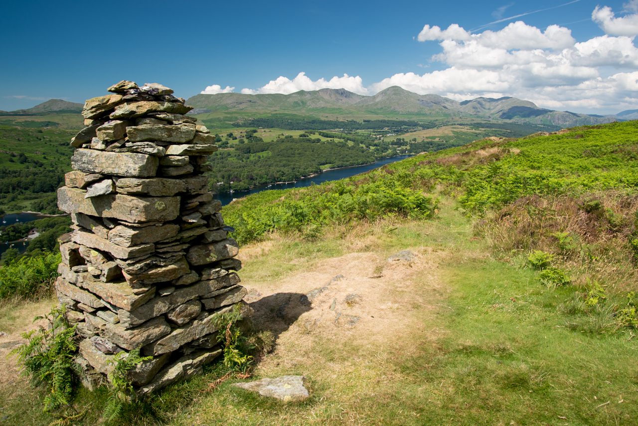
The Coniston fells from the summit cairn.

610_0926-Edit

A panorama of the Coniston fells.

610_0938

Brothers in arms - Dougal and Fletcher.

610_0942

It\'s a beautiful evening.

610_0945

The view from the secondary summit.

Brock Barrow

Walked on 02/03/2015

Start Point: High Nibthwaite (SD 294 897)

Brock Barrow from High Nibthwaite

Distance: 1.5 miles     Total Ascent: 175 metres     Time Taken: 40 minutes     Start Time: 10:15

Weather: Heavy snow showers, 1°C

Everywhere I went this morning there were heavy snow showers with it settling on the roads in many places. I ended up deciding on a short walk to somewhere that was not too high given the wind strength down at valley level and ended up getting a pleasant surprise with the way the weather turned out. Given the earlier conditions I don’t think I could have asked for any more.

Book One 10 reasons 02.jpg

An open invitation to StridingEdge fans - what are you doing at Easter? It would be great to see you at the launch of the latest Wainwright book update.

610_9243.jpg

I didn't hold out much hope for this short walk, this is what it was like most of the morning and it continued as I set off towards Brock Barrow.

610_9251.jpg

Lo and behold - 5 minutes later the wind had blown away the snow shower and there was a blue sky up there!

610_9255.jpg

The Crake Valley from the climb.

610_9256.jpg

Near the top now and there is a wintry view to High Bethecar to the east.

610_9260.jpg

At least I can almost see the snow clad Coniston fells from the top now.

610_9263.jpg

Looking down on High Nibthwaite and Allan Tarn.

610_9270.jpg

The two of them - ready to pounce.

610_9275.jpg

The summit cairn.

610_9277.jpg

Heading for the secondary summit, The Old Man and Wetherlam beyond.

610_9281.jpg

Coniston Water.

610_9289.jpg

Look into the eyes...

610_9300.jpg

Yes, I can smile.

610_9301.jpg

Looking across to Caw and leaden skies.

610_9303.jpg

The eastern side of Coniston Water on the way down.

610_9305.jpg

The Gormley statue is now imprisoned.

610_9307.jpg

Beacon Fell from a full Coniston Water.


Brock Barrow

Height: 229 metres / 751 feet Grid reference: SD 29881 89881 Category: The Outlying Fells

Brock Barrow

Brock Barrow

Brock Barrow

Walked on 28/11/2014

Start Point: High Nibthwaite (SD 294 897)

Brock Barrow from High Nibthwaite

Distance: 1.5 miles     Total Ascent: 175 metres     Time Taken: 40 minutes     Start Time: 09:00

Weather: Overcast, 6°C

Should I, shouldn’t I, should I, shouldn’t I…oh, go on then – time was very short this morning and I did intend to have a low level walk with the boys around Coniston somewhere but then was magically drawn skywards by diminutive Brock Barrow. It was a bit drab and a bit cool but watching Fletcher made me smile – it wasn’t so long ago (July 11th to be exact!) that he climbed this as a small pup and I worried whether it would be too much for the little fella. Now he is as big as Dougal and positively bounded up here…he’s going to be a fine fellwalking dog that Fletcher.

610_6731

Beacon Fell across Nibthwaite.

610_6735

On the way - Fletcher is watching Dougal...in the bracken somewhere!

610_6738

Allan Tarn from the steep climb.

610_6740

The cairn looking to Caw.

610_6750

Ready to pounce.

610_6758

Fluffy Fletcher.

610_6762

It's a bit grey over the southern end of Coniston Water.

610_6766

Onto the secondary summit.

610_6770

The Watcher.

610_6774

Down at Coniston Water.

Brock Barrow

Walked on 11/07/2014

Start Point: High Nibthwaite (SD 294 897)

Brock Barrow (OF) from High Nibthwaite

Distance: 1.5 miles     Total Ascent: 175 metres     Time Taken: 1 hour     Start Time: 13:30

Weather: Boiling, 25°C

Today seemed as good a day as any to get out on the fells with young Fletcher – of course, with him being so young it had to be short and sweet but he seemed to take to it okay even in the hottest of summer conditions. It was absolutely gorgeous up there today, certainly the warmest weather I have been out in for a while.


610_4568

All is bright and all is green at the start of the walk from High Nibthwaite.

610_4569

Looking across Allan Tarn.

610_4570

Brock Barrow - lots of heat and lots of flies for us to contend with today.

610_4574

The Coniston fells from the top of Brock Barrow.

610_4586

Made it Fletcher - good lad!

610_4604

Fletcher has more than a hint of Casper about him.

610_4623

Heading for the second cairn.

610_4635

Hot!

610_4637

A fabulous view of Coniston Water and the fells.

610_4646

Keeping an eye on things.

610_4658

Back down at Coniston Water.

610_4663

That looks like a good place to be.

610_4676

Fletcher is a swimmer!

610_4681

Our old friend keeping an eye on proceedings.

Bethecar Moor

Walked on 14/05/2013

Start point: High Nibthwaite (SD 295 897)

High Nibthwaite – Brock Barrow (OF) – Low Light Haw (OF) – High Light Haw (OF) – Stang Hill – Arnsbarrow Hill – Top o’ Selside(OF)– High Nibthwaite

Distance: 4.1 miles     Total Ascent: 347m metres     Time Taken: 1 hours 30 minutes     Start Time: 09:20

Weather: Sunny spells. A cool 9oC.

It may be May (!) but it doesn’t particularly feel like it, the shorts and tee shirt are still not in evidence yet. Dougal (and Casper) have gone for it though having lost their winter coats ready for the long hot summer ahead. It was just me and Dougal again today for a jaunt along the east side of Coniston Water up on Bethecar Moor, a fairly relaxed walk with some great views.

01 Bethecar Moor

P5143555

Caught in a shower heading for Brock Barrow.

P5143558

Lo and behold! The sun is shining on the climb.

P5143560

They made me do it.

P5143566

Looking back down on the climb.

P5143570

The Coniston fells from Brock Barrow.

P5143584-Edit

A panoramic view of the Crake Valley and the foot of Coniston Water.

P5143590

Very dapper Dougal!

P5143596

The Old Man and Wetherlam beyond the second summit...

P5143598

...and the view from it.

P5143600

The rest of the tops in this walk can be spotted from Low Light Haw - directly ahead to High Light Haw, Stang and Arnsbarrow Hill to the right and Top o' Selside distant left.

P5143606

Coniston Water, Beacon Fell and Caw from High Light Haw.

P5143607

The route to Stang Hill.

P5143609

Heading across Stang Moss.

P5143615_6_7

Helvellyn to Fairfield to Red Screes to Ill Bell from Stang Hill.

P5143632

Arnsbarrow Tarn, Top o' Selside beyond.

P5143637-Edit

A panorama of Arnsbarrow Tarn.

P5143644

A little bit of sunshine on Top o' Selside.

P5143647

Looking in the opposite direction to distant Morecambe Bay and Black Comb.

P5143658-Edit

A Coniston panorama on the way back to Low Nibthwaite.

Brock Barrow

Walked on 05/04/2013

Start point: High Nibthwaite (SD 294 897)

Brock Barrow (OF) from High Nibthwaite

Distance: 1.5 miles     Total Ascent: 175 metres     Time Taken: 40 minutes     Start Time: 17:25

Weather: Cool. 5oC

Casper enjoyed it so much the other day I thought I’d give him the opportunity of another jaunt to a small fell, it was good to have him back although nothing has changed – he is still officially retired unfortunately.

01 East of Coniston

P4052594

High Nibthwaite and Beacon Fell.

P4052595

Over Allan Tarn to Blawith Knott.

P4052597

Brock Barrow.

P4052602

There's still life in the old dog yet.

P4052608_09_10_fused

The Coniston fells from Brock Barrow.

P4052614_5_6_tonemapped

A burst of sunshine over the Crake Valley.

P4052621

Coniston Water and fells.

P4052623

Old pals.

P4052632_3_4_tonemapped

Brock Barrow.

P4052641

The second summit ahead, Wetherlam beyond.

P4052651

The call of the wild.

P4052657

Time for a swim (for Casper and Dougal, not me I hasten to add!) down at Nibthwaite.

P4052658

The Old Man at the head of Coniston Water.

P4052664_5_6_tonemapped

He's keeping a watchful eye on proceedings.

Caw

Walked on 27/11/2012

Start point: Kiln Bank Cross (SD 215 933)

Kiln Bank Cross – Park Head Road –  Brock Barrow – Long Mire – Caw (OF) – Park Head Road – Kiln Bank Cross

Distance: 3.3 miles     Total Ascent: 413 metres     Time Taken: 1 hour 40 minutes     Start Time: 09:20

Weather: Sunny spells with a cool wind. 7oC

There has been plenty of rain around over the last week or so but the Lake District has escaped the severe flooding that other parts of the country have been unfortunate enough to endure. It almost seemed impossible that we could get some dry weather at last after it rained relentlessly all day yesterday but here we have it – a rare dry day! The tops of the highest fells have a covering of snow and the wind up on top was pretty cold today.


Caw

PB278169

The Park Head Road - a bit damp underfoot but not from above, thankfully.

PB278171

Brock Barrow.

PB278172

An interesting and different route to Brock Barrow following an old quarry track, the zig-zags of which can be seen quite clearly.

PB278175

Looking across the Duddon Valley from the ruined quarry buildings to The Pike and Hesk Fell, Whitfell beyond.

PB278179

Stickle Pike in mono.

PB278181

Stickle Pike and Black Combe. These workings are more extensive than I realised.

PB278186

Caw and a bit of blue sky.

PB278188

Snow capped Grey Friar and Swirl How.

PB278191

The high fells at the head of the Duddon Valley are lost under a thick belt of cloud.

PB278196

Sunshine over Morecambe Bay, Heysham Power station silhouetted.

PB278200

Lots of weather going on in the Duddon Valley as I reached the top of Caw.

PB278207

Black Combe from Caw.

PB278212

There was a strong, cold wind up here today.

PB278216

The Coniston fells.

PB278225

The look that says a thousand words...

PB278232

...and so does this one, something akin to 'Get a move on'!

PB278236

Grey Friar, grey sky.

PB278241

The Duddon Estuary.

PB278243

The Fell Dogs.

PB278245

Dougal portrait.

PB278247

Dougal the Woolly Jumper, proudly standing atop a wall today. He scaled the north face of the 6' wall in one bound. The reason? 'Because it was there'

PB278251

The way back, following the wall which follows the lay of the land, in and out.

PB278253

A bit brighter over Stickle Pike now.

Brock Barrow

Walked on 10/08/2012

Start point: High Nibthwaite (SD 294 897)

Brock Barrow (OF) from High Nibthwaite

Distance: 1.5 miles     Total Ascent: 175 metres     Time Taken: 1 hour 20 minutes     Start Time: 11:00

Weather: Hot and sunny. 23°C

It was really warm this morning – Connie, we are going out for a walk…your choice…!

01 East of Coniston.jpg
P8104650.jpg
P8104652.jpg
P8104654.jpg
P8104659.jpg
P8104667.jpg
P8104668.jpg
P8104669.jpg
P8104670.jpg
P8104672.jpg
P8104676.jpg
P8104682_stitch.jpg
P8104690.jpg
P8104698.jpg
P8104707.jpg
P8104713.jpg
P8104716.jpg
P8104733.jpg
P8104759.jpg
P8104763.jpg
P8104768.jpg
P8104770.jpg

Brock Barrow

Walked on 24/05/2012

Start point: High Nibthwaite (SD 294 897)

Brock Barrow (OF) from High Nibthwaite

Distance: 1.5 miles     Total Ascent: 175 metres     Time Taken: 45 minutes     Start Time: 09:30

Weather: Warm and hazy. 18°C

Summer has returned to the Lake District and it has been warmer than warm this week. I have not been doing much walking this week but have been out and about with my camera as shown in the first set of shots. Today I had a short walk up to Brock Barrow at the southern end of Coniston Water.

01 East of Coniston.jpg

P5223313.jpg

I couldn't resist this scene on Tuesday...

P5223320.jpg

...I thought it looked like one of those scenes from yesteryear.

P5223325.jpg

A mirror finish on Coniston Water at Parkamoor Jetty.

P5223327.jpg

Perfect.

P5223328.jpg

Beacon Fell from the jetty.

P5223334.jpg

The Coniston fells.

P5223335.jpg

Coniston Water.

P5223354.jpg

Coniston Bluebells - about to be overtaken by the bracken.

P5223358.jpg

Looking good in the sunshine though. Tuesday was also (bad?) haircut day for the boys and with the threatened good weather coming, they needed it.

P5223380.jpg

Shaking out the cobwebs at Roanhead.

P5223386.jpg

Bath time. On Wednesday, it was a real scorcher...

P5233389.jpg

The Langdale Pikes from Elter Water.

P5233400.jpg

A good place to be.

P5233416.jpg

The Langdale Pikes. On with the walk...

P5243417.jpg

All is calm at Lake Bank, the mist is just starting to burn off and you can see it up to the right. Also missing are the Coniston fells, still hidden by the mist to the north.

P5243420.jpg

Another day of perfect reflections.

P5243425.jpg

Beautiful.

P5243440.jpg

Climbing from Nibthwaite, Beacon Fell is over the rooftops but to the right the mist is clearing from the Coniston fells now.

P5243444.jpg

Climbing higher looking across Allan Tarn to the big bank of fog sitting over the edge of the coast.

P5243445.jpg

The steep way up.

P5243447.jpg

The Coniston fells from Brock Barrow.

P5243450.jpg

It is slightly hazy today but very warm up here.

P5243461.jpg

The view from the second cairn.

P5243467.jpg

Looking down on Coniston Water.

P5243468.jpg

The Old Man and Wetherlam reflected.

P5243474.jpg

The long tongues and short fur tell the tale of the thermometer today.

P5243481.jpg

Back down at Nibthwaite, looking across to Beacon Fell.

P5243489.jpg

Up periscope.

Brock Barrow

Walked on 16/04/2012

Start point: High Nibthwaite (SD 294 897)

Brock Barrow (OF) from High Nibthwaite

Distance: 1.5 miles     Total Ascent: 175 metres     Time Taken: 1 hour 15 minutes     Start Time: 12:00

Weather: Overcast. 8oC

Connie is still off school so we went for a walk to Brock Barrow above High Nibthwaite. Around the fringes of the southern Lake District it was really sunny but further in it was a little overcast.

P4162297

A busy lunchtime in High Nibthwaite.

P4162298

Climbing above the rooftops looking towards beacon Fell.

P4162308

The steep scramble to the top.

P4162321

Hands on action looking along the Crake Valley.

P4162326

The Coniston fells.

P4162333-2

A breather at the top of Brock Barrow for Connie, Casper and Dougal. Incidentally, that cairn was built by A H Griffin, he said 'It was the first and only summit cairn I have ever built'.

P4162339

As for the view from here, Griffin wrote: '...a magnificent viewpoint for the length of the lake and the mountains behind...'

P4162341

Looking across Allan Tarn and Nibthwaite to Black Combe across the Blawith fells.

P4162353

We are all enjoying the views today.

P4162355

Wetherlam beyond the second summit.

P4162361

Sheep spotters gather at the end of the (rock) platform.

P4162372

You look that way and I'll look this. Back down at the foot of Coniston Water...

P4162389

Dougal walks on water whilst Casper sinks (or swims).

P4162394

Caught in a trap.

P4162397

The sentinel Gormley statue guards Beacon Fell.

P4162401

Bouthrey Bridge has recently re-opened after being completely destroyed in the 2009 floods.

P4162405

This was the last bridge in Cumbria to be reconstructed after the devastation, hopefully it will never see that level of water again but at least it is wider and looks more substantial now.

P4162407

The St John's Ambulance first aid box on the wall at Water Yeat. This was completely renovated a few years ago and I believe it was the first such box anywhere in the country.

Brock Barrow

Walked on 28/10/2011

Start point: High Nibthwaite (SD 294 897)

Brock Barrow (OF) from High Nibthwaite then Blawith Common

Distance: 1.5 miles     Total Ascent: 175 metres     Time Taken: 45 minutes     Start Time: 08:50

Weather: Sunny, cold. 2ºC

It was a lot cooler this morning and altogether more autumnal than of late. The colours were really showing up in the sunshine and Coniston Water was completely calm with a polished mirror finish making for some great photos at the end of today’s short walk.

East of Coniston

Brock Barrow route map.

28.10.11-001

Looking across Nibthwaite to the southern end of Coniston Water, the early mist rising off the lake.

28.10.11-004

Looking across to the Blawith fells, the mist on Allan Tarn.

28.10.11-043

Sunshine boys.

28.10.11-051

Climbing out of the shadows.

28.10.11-054

Summit vista.

28.10.11-057

The Coniston fells from Brock Barrow.

28.10.11-072

The Crake Valley.

28.10.11-112

A mighty fine cairn.

28.10.11-115

Coniston Water and fells.

28.10.11-118

Dow Crag and The Old Man.

28.10.11-127

The second summit and the Coniston fells.

28.10.11-142

There is a mirror finish on Coniston Water below, Lake Bank Jetty to the left.

28.10.11-167

Casper and Dougal, sheep spotting.

28.10.11-192

Across Coniston Water.

28.10.11-195

28.10.11-201

It's looking so good in the sunshine down there... ...down at the lake side...

28.10.11-204

There is still a bit of mist lingering on the water looking across to Beacon Fell.

28.10.11-207

The distant Old Man at the head of Coniston Water.

28.10.11-213

Stillness.

28.10.11-216

From the boathouse. From the western side of Coniston Water...

28.10.11-222

Lake Bank Jetty.

28.10.11-231

The Coniston fells from Lake Bank jetty.

28.10.11-234

Autumn colours.

28.10.11-237

It's really tranquil looking south.

28.10.11-240

The giants of Coniston.

28.10.11-243

Coniston Water.

28.10.11-255

Reflected sky.

28.10.11-261

Just beautiful.

Brock Barrow

Walked on 22/08/2011

Start point: High Nibthwaite (SD 294 897)

Brock Barrow (OF) from High Nibthwaite

Distance: 1.5 miles     Total Ascent: 175 metres     Time Taken: 1 hour 15 minutes     Start Time: 11:25

Weather: Sunny and warm. 18°C

It wasn’t the walk we set off to do earlier today but we were glad to have changed to the sunny eastern side of Coniston Water and we enjoyed a walk up to Brock Barrow and along the ridge in beautiful weather amongst the sweet smelling Ling. I think the views of Coniston Water and the Coniston fells are amongst the best from here and are certainly the best for minimal effort.

22.08.11-024

Brock Barrow ahead with a promise of blue sky.

22.08.11-035

The climb through deep bracken.

22.08.11-037

Looking across Allan Tarn to Blawith Knott from the climb.

22.08.11-051

Scramble girl.

22.08.11-053

Sunlight on the fells.

22.08.11-057

From the top of the rake.

22.08.11-084

The summit cairn in amongst the Ling.

22.08.11-086

Casper and Dougal, the Lingy Lads.

22.08.11-091

Looking across to Low Light Haw.

22.08.11-094

The Coniston fells from Brock Barrow.

22.08.11-117

It was a lovely day to sit here and admire the views.

22.08.11-131

Caw and White Maiden.

22.08.11-143

The Crake Valley.

22.08.11-149

Bethecar Moor from the cairn.

22.08.11-150

Longer sunny spells as we head to the secondary summit.

22.08.11-154

The second summit and a great view of Coniston Water.

22.08.11-156

Coniston close up.

22.08.11-160

Black Sails and Wetherlam past the summit.

22.08.11-161

Coniston in mono.

22.08.11-164

Summit wall.

22.08.11-172

Connie on the cairn.

22.08.11-174

Casper enjoys the fabulous view.

22.08.11-185

A panoramic view of Coniston.

22.08.11-186

Dappled fells. Back down at Nibthwaite...

22.08.11-193

The sentinel and the Coniston fells.

22.08.11-198

Lovely down by the quay.

22.08.11-202

Beacon Fell.

22.08.11-207

Brock Barrow - you can just about make out the cairn.

22.08.11-215

Up by Parkamoor Jetty, we were going to have a swim but decided a paddle was enough after all!

22.08.11-220

Parkamoor Jetty.

Coniston Inversion

Walked on 03/03/2011

Start point: High Nibthwaite (SD 294 897)

Brock Barrow (OF) from High Nibthwaite then Blawith Common

Distance: 1.5 miles     Total Ascent: 175 metres     Time Taken: 20 minutes     Start Time: 08:40

Weather: Clear above the mist. -4ºC below cloud, much warmer above!

I had no plans for a walk today but saw the early morning dense fog and decided I would go for it! It is always nice to be able to get above the cloud like this and being out early gave me the chance to have two bites of the cherry as I firstly had a look from the east side of Coniston before a quick travel to Blawith Common for a look from the west side.

03.03.11-014

Underneath the cloud cover at Lowick these sheep and lambs must have thought they were in for a feed as they ran towards me, bleating loudly.

03.03.11-023

The Lambster.

03.03.11-031

Frozen ground heading for Brock Barrow. I went up the front face for a change - to the left in this photo and then up.

03.03.11-032

What do you think of this tree Casper?

03.03.11-036

Looking south along the Crake Valley.

03.03.11-037

...and north towards the Coniston fells.

03.03.11-050

Beacon Fell from the climb.

03.03.11-054

Flare on the summit cairn.

03.03.11-056

Beautiful in the sunshine up on Brock Barrow.

03.03.11-070

They're loving it.

03.03.11-084

Nibthwaite down below and Blawith Common. Looks interesting over there which has given me an idea.

03.03.11-100

The second summit on Brock Barrow.

03.03.11-103

The view from its cairn.

03.03.11-117

A profile - Casper, Dougal (and a distant Angus).

03.03.11-124

What's down there boys? My guess is they featured in the first two photos of this walk.

03.03.11-126

I think I will head over to the other side when I get down.

03.03.11-131

The frozen wall to Nibthwaite. Then a short drive to Blawith Common to check the inversion from the west side...

03.03.11-141

The view from the climb to Slatestone fell.

03.03.11-151

Looking south into the sun and the mist is burning off rapidly now. This is Bowder Knott, normally it wouldn't even be worth a visit or a mention but these smaller knotts and knolls are on the very edge of the inversion today.

03.03.11-157

The view along Coniston Water to Wetherlam from the descent.

03.03.11-159

Heading for Lake Bank above the Crake valley caravan park. It sounds like it's raining with the ice rapidly thawing from the trees and bushes.

03.03.11-160

Looking across to Nibthwaite and Brock Barrow, visited earlier.

03.03.11-163

A great profile of the Coniston fells.

03.03.11-172

Nearly clear down at Lake Bank with only a couple of swans to greet me.

03.03.11-175

A familiar view? Lake Bank Jetty features as the April photo on the Striding Edge 2011 calendar and appears on the Frosty Mornings Reed Diffuser box that we sell in Love the Lakes!

03.03.11-181

Oak Isle tranquillity.

Brock Barrow

Walked on 19/11/2010

Start point: High Nibthwaite (SD 294 897)

Brock Barrow (OF) from High Nibthwaite

Distance: 1.5 miles     Total Ascent: 175 metres     Time Taken: 20 minutes     Start Time: 10:30

Weather: Sunny with clearing mist. 5C

I just about had time for a quick walk at the southern eastern end of Coniston Water today and I think it caught the best of the early weather as there was lots of low lying mist, but also the high fells were covered too. This is a good walk for the effort/view ratio and there is rarely anyone around here.


19.11.10-008

Misty morning in the Crake Valley.

19.11.10-012

Dougal and Casper lead the way.

19.11.10-016

Looking to the Blawith Fells (where I walked on Monday) across Allan Tarn.

19.11.10-018

The scramble to the top.

19.11.10-024

The mist is being burned away by the sun.

19.11.10-026

Coniston Water from Brock Barrow, the high fells are cloud covered for now.

19.11.10-037

Casper and Dougal.

19.11.10-041

He's like a coiled spring, that Dougal - look at him, ready to bounce away.

19.11.10-045

The southern end of Coniston Water.

19.11.10-047

Beacon Fell.

19.11.10-054

Misty trees.

19.11.10-056

The Crake Valley in mono.

19.11.10-061

Brock Barrow from Allan Tarn.

19.11.10-063

Allan Tarn is a widening of the River Crake as it flows from Coniston Water.

19.11.10-068

Looking into the sun at Allan Tarn, known as Octopus Lagoon in Ransome's 'Swallows and Amazons'.

19.11.10-069

'Noah's Ark' (so that's where it went!) hidden in the trees at Allan Tarn.

19.11.10-076

High Nibthwaite (properly) or more usually, locally - 'Nibthet'.

Brock Barrow

Walked on 24/10/2010

Start point: High Nibthwaite (SD 294 897)

Brock Barrow (OF) from High Nibthwaite

Distance: 1.5 miles     Total Ascent: 175 metres     Time Taken: 1 hour     Start Time: 13:50

Weather: Sunny and clear. 9C

What a fantastic and clear day it was today – too nice to stay in, so Connie and I took the dogs for a short walk somewhere. We didn’t end up where we intended, read on to find out why…

24.10.10-001

The River Leven at Backbarrow. Many will remember the flood photos from 20th November last year and at last the parapet on the bridge has been repaired and the road has re-opened.

24.10.10-005

The River Leven from the bridge.

24.10.10-013

Looking downstream. The intention was to go to High Dam today but when we drove through Finsthwaite, I could hardly believe how busy it was and I have never seen so many cars there. The car park was full and the roads were lined with cars for qyuite a distanbce. Hmm, we'll give that a miss then and find somewhere a bit quieter I think.

24.10.10-024

Back down at Newby Bridge, the weir on the River Leven.

24.10.10-029

We ended up at High Nibthwaite at the foot of Coniston Water - I know it's not that long since I was there but the views are quite stunning from this diminutive fell on a day such as this. This is the view across High Nibthwaite towards NBeacon Fell at the start of the walk.

24.10.10-034

Brock Barrow.

24.10.10-044

Connie and the Crake Valley on the climb towards High Bethecar.

24.10.10-050

Crake Valley sunshine.

24.10.10-055

The southern end of Coniston Water.

24.10.10-056

The Coniston fells from the top.

24.10.10-060

Allan Tarn and distant Black Combe.

24.10.10-065

Dow Crag and The Old Man.

24.10.10-066

Close up ion The Old Man of Coniston.

24.10.10-067

Brown Pike, Buck Pike and Dow Crag.

24.10.10-070

A riot of colour looking across to Beacon Fell, Caw on the skyline.

24.10.10-103

Casper, Connie and Dougal.

24.10.10-106

Rock the Casper.

24.10.10-113

The view from the cairn on Brock Barrow.

24.10.10-115

Crossing the wall at the start of the descent.

24.10.10-121

We descended the Wainwright way at Connie's behest - not recommended! Nice Holly tree on the way down though!

24.10.10-127

Connie on the way down.

24.10.10-131

The sentinel looks towards Coniston fells.

24.10.10-136

Connie and her new friend at the foot of Brock Barrow.

24.10.10-139

Beacon Fell from Coniston Water.

24.10.10-147

The view from the foot of Coniston Water.

Brock Barrow

Walked on 22/09/2010

Start point: High Nibthwaite (SD 294 897)

Brock Barrow (OF) from High Nibthwaite

Distance: 1.5 miles     Total Ascent: 175 metres     Time Taken: 25 minutes     Start Time: 13:20

Weather: Started off dry, ended up rain. 17C

There was just time for a quick walk with the dogs at the south eastern side of Coniston Water this afternoon. I thought I would have escaped the rain but as soon as I made the top, the heavens opened. It is very rare to see anyone up on this side but I bumped into three people who just happened to be StridingEdge fans today – nice to meet you all.


East of Coniston

Brock Barrow route map.

003

Beacon Fell across Coniston Water and Nibthwaite.

005

Brock Barrow and gorse.

014

The trees are certainly on the turn now.

018

Three people sat on the summit were rudely interrupted by boisterous Dougal - good job they were StridingEdge fans, otherwise they may not have been so keen to see him!

021

Dougal and Casper on the summit.

025

Beacon Fell, the rain falling now.

031_stitch

A panoramic view of the southern end of Coniston Water.

035

Dougal heading for the second summit.

048

In your face.

067

Watching the world (well, sheep actually) go by.

074

Heading back down to Nibthwaite.

087

Down at the lake shore in Nibthwaite, Coniston Water is looking full.

092

From the boathouse.

093_stitch

A panoramic view along Coniston Water.

098

Gormley statue and Brock Barrow.

Brock Barrow

Walked on 21/03/2010

Start point: High Nibthwaite (SD 294 897)

Brock Barrow (OF) from High Nibthwaite

Distance: 1.5 miles     Total Ascent: 175 metres     Time Taken: 45 minutes     Start Time: 10:00

Weather: Sunny and warm, 12C

Underneath the dense cloud it was chilly but the sun soon burned it away this morning leaving conditions sunny and warm for a short walk at the southern end of Coniston Water. I had my first outing with some new boots on and will give a full review of them soon. What I can say is that they were fantastic and will be well worth checking out…

East of Coniston

Brock Barrow route map.

21.03.10-002

Our old friend, the Antony Gormley statue at High Nibthwaite.

21.03.10-005

It was lovely and calm this morning. Further north the lake was shrouded in mist but was clearing from the southern end.

21.03.10-007

Reeds and Beacon Fell.

21.03.10-009

21.03.10-012

Beacon Fell across the rooftops of High Nibthwaite.

21.03.10-014

Allan Tarn and clearing cloud.

21.03.10-017

Spring springing at Brock Barrow.

21.03.10-020

The route of ascent, definitely not the Wainwright one which he got completely wrong.

21.03.10-023

Looking down on Allan Tarn.

21.03.10-026

The cloud is lifting from the Coniston fells and Coniston Water is clear now from the summit of Brock Barrow,.

21.03.10-037

Dougal and Casper enjoying the sunshine.

21.03.10-040

Beacon Fell and the southern end of Coniston Water.

21.03.10-052

The Coniston fells.

21.03.10-074

The 'castle' of the second summit on Brock Barrow.

21.03.10-085

Two's company.

21.03.10-092

The view from the second summit.

21.03.10-093

Big cloud over Black Combe.

21.03.10-119

How to get two mucky pups clean at Low Peel Near. On the way home...

21.03.10-125

A host of golden Daffodils outside Ulverston.

21.03.10-136

A carpet of purple Croci at Urswick.

Caw

Walked on 29/01/2010

Start point: Kiln Bank Cross (SD 215 933)

Kiln Bank Cross – Park Head Road –  Brock Barrow – Long Mire – Caw (OF) – Park Head Road – Kiln Bank Cross

Distance: 3.5 miles     Total Ascent: 300 metres     Time Taken: 1 hour 30 minutes

Weather: Cold and clear. 2°C

It was almost unexpected today for the weather to turn so good so suddenly. The sun came out when I was booting up (footwear, not PC!) and stayed throughout the walk. The wind though was a really cold northerly – an icy blast. We bumped into Oscar the Beardie at the start, a regular on these fells and one we have seen a good few times before. As you can imagine, there was fur and wagging tails everywhere! By the end of the walk it was snowing really heavily and the high fells certainly had a good fall of new snow on them. Is this the resurgence of winter?

29.01.10-007

"...look at the mighty Caw, this pyramid, this mountain, this fell of fells. From the vale of the Duddon the Bearded fellows will unite with the fell-ninja, rise to the top and cast asunder all ye below..." extract from The Legend of Beenson Toste

29.01.10-002

As soon as I arrived at Kiln Bank Cross, the sun came out and the sky was blue. This is looking up to Stickle Pike from the road, but we headed the other way towards Caw this morning.

29.01.10-008

Harter Fell flanked by Scafell and Esk Pike.

29.01.10-025

Stickle Pike and Black Combe from a frozen pool on Brock Barrow.

29.01.10-028

Caw - our path is along Long Mire, up to the right.

29.01.10-037

The Duddon Valley from Brock Barrow - those poles are aerials for the valley below.

29.01.10-046

A bit windy up here Dougal?

29.01.10-050

Fox Haw and the track just followed from Brock Barrow over to the right.

29.01.10-051

Caw and the route up - the McMahon direct route.

29.01.10-064

Looking across to Black Combe from the climb. to the right is Brock Barrow (a different one to the one I have just been on!) with Stickle Pike the nearer fell.

29.01.10-069

Hurry up dad! They are much quicker than me up here with 4 leg drive.

29.01.10-081

Caw summit.

29.01.10-084

Looking across to the Coniston fells.

29.01.10-087

Fresh snow on the high fells at the head of the Duddon Valley.

29.01.10-106

Looking into the sun to the south.

29.01.10-108

The Duddon Estuary.

29.01.10-113

The Duddon Valley from the descent.

29.01.10-121

Esk Pike and Bowfell.

29.01.10-123

Dow Crag and the Seathwaite Fells surrounding The Cove.

29.01.10-125

Snowy Scafell and Scafell Pike, Harter Fell in the foreground.

29.01.10-132

A greener looking Whitfell and The Pike across the Duddon Valley.

29.01.10-137

A final view of the Duddon Valley before heading back to Kiln Bank Cross.

29.01.10-154

Some of the famous Lake District Herdwick sheep.

Brock Barrow

Walked on 07/08/2009

Start point: High Nibthwaite (SD 294 897)

Brock Barrow (OF) from High Nibthwaite

Weather: Sunny. 20C.

Dougal came of age today being exactly 13 weeks old – what that means in young puppy terms is that you are allowed out into the big wide world, confident that you will not pick up any strange illnesses. For a short and easy walk to tire the young chap out, I decided to climb Brock Barrow at the foot of Coniston Water. It is funny how certain fells bring back memories and this holds more than its fair share for me. It was the fell that Angus got lost on one time and also the last fell he climbed before he hung up his boots (barring the Lance Armstrong style comeback for a crack at climbing Gummer’s How), so it was fitting that this should be Dougal’s first. Unsurprisingly, he carried the walk off with aplomb – he’s going to be a good ‘un that lad, I can tell that for sure.

East of Coniston

Brock Barrow route map.

07.08.09-001

Looking back to Beacon Fell over High Nibthwaite. It was a jungle up there.

07.08.09-004

Allan Tarn, Blawith beyond. Tottlebank Height is the highest point to the right.

07.08.09-010

Heading for Brock Barrow. The climb to it is not as bad as it looks and I think Wainwright gave a poor route to get up to it in his Top o' Selside walk in The Outlying Fells. In those days, it was a nameless summit 748' and the route he describes is a steep scree climb straight up this face of it along the visible groove. However, if you carry on along the path to the east (to the right of this photo), the climb is much gentler before it cuts back to the north west to reach the top. The main obstacle on this route at the moment is the bracken.

07.08.09-016

Hurry up Uncle Casper.

07.08.09-032

Heathery Casper.

07.08.09-035

Made it! Well done Dougal, the first of many I think and he was such a good lad.

07.08.09-043

The Coniston fells from the cairn on Brock Barrow. The views were superb today with a light breeze blowing on the top making it a classic English summer day.

07.08.09-060

Little Dougal looks impressed.

07.08.09-066

Where are you skulking off to?

07.08.09-069

The dogless view.

07.08.09-075

Looking across Allan Tarn to Blawith Knott and Black Combe, below is High Nibthwaite.

07.08.09-077

The foot of Coniston Water.

07.08.09-097

We stayed here for a good while, having a lie in the grass and enjoying the sun giving Dougal plenty of recovery time.

07.08.09-103

There were lots of new things to see for him.

07.08.09-106

Looks like he has inherited the Casper tongue as well.

07.08.09-110

The Coniston fells across the blooming heather.

07.08.09-115

Heading for the second cairn.

07.08.09-116

Low Light Haw from the second cairn.

07.08.09-120

Coniston Water.

07.08.09-127

Dow Crag and The Old Man.

07.08.09-129

Wetherlam and the Yewdale Fells.

07.08.09-152

Beacon Fell.

07.08.09-153

What a day.

07.08.09-158

I descended directly to the track running across the centre of this photo. The path was often lost in the head height bracken and old Dougally Doo required a bit of a carry here, after all some of you may remember what happened to Angus a couple of years ago when the bracken was a similar height - he disappeared!

07.08.09-161

The Gormley Sentinel keeps an eye on Beacon Fell back down at High Nibthwaite.

07.08.09-166

It was tempting for a swim here.

07.08.09-188

Tranquillity in Swallows and Amazons country.

  • 1
  • 2
  • Next Page »

Walking Diary

  • The Mosedale Horseshoe 01/03/2022
  • Caw 18/01/2022
  • Coniston sunset 17/01/2022
  • Blencathra 15/01/2022
  • Scafell Pike 14/01/2022

Social

  • Facebook
  • Twitter

Information

  • Striding Edge
  • T&C’s
  • Privacy
  • Links