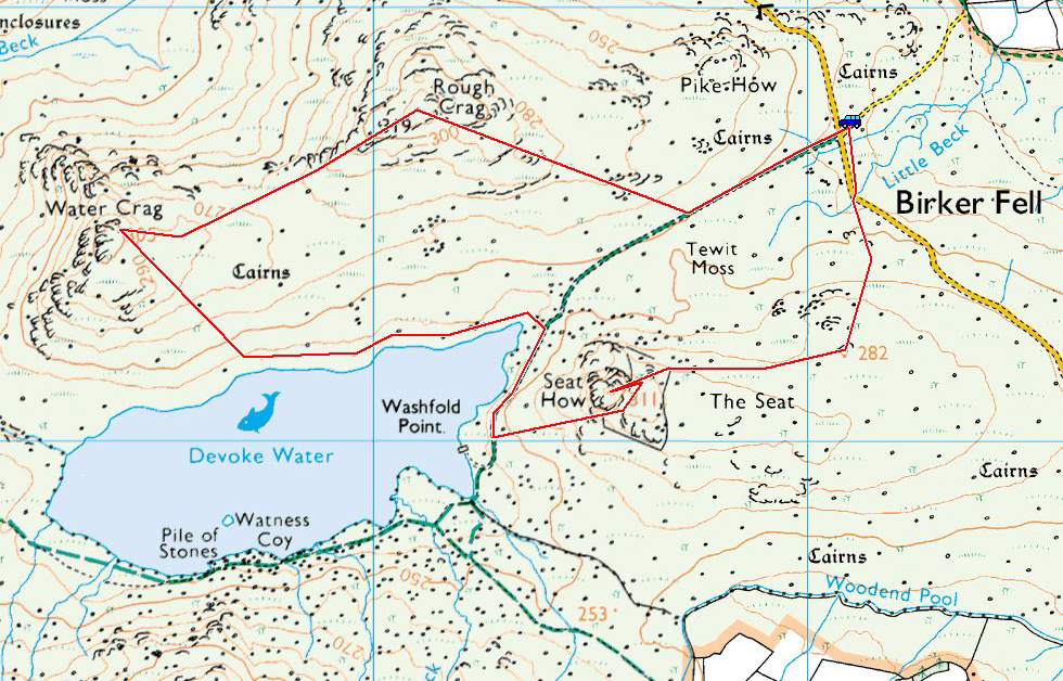
Striding Edge

A photo diary of Lake District fell walks

  • Dogs
  • Contact
  • Fells
    • Wainwrights
      • Eastern Fells
      • Far Eastern Fells
      • Central Fells
      • Southern Fells
      • Northern Fells
      • North Western Fells
      • Western Fells
      • Outlying Fells
    • Birketts
  • Information
    • About Striding Edge
    • Striding Edge
    • T&C’s
    • Privacy
    • Links
  • Walking Diaries
    • 2025 Walking Diary
    • 2024 Walking Diary

Beacon Fell

Walked on 26/06/2014

Start Point: At the end of the minor road from Brown Howe (SD 281 916)

Beacon Fell (OF) from Tottle Bank

Distance: 2 miles     Total Ascent: 200 metres     Time Taken: 50 minutes     Start Time: 09:30

Weather: Grey. 15°C

It was completely different weather today to that of Monday – gone was the lovely sunshine to be replaced with general murk and dreariness. Early on it was drizzling too but that soon cleared as we headed up to Beacon Fell for a bit of fresh air.

Beacon Fell Map

610_4073

Parkamoor Jetty (in the drizzle) looking across to Beacon Fell.

610_4075

Side view of the jetty.

610_4083

Beacon Fell ahead as Dougal negotiates the long grass and bracken.

610_4085

Climbing the gully to the top.

610_4088

Coniston Water from Beacon Fell. The treasure tin is still there.

610_4096

Dougal in a thoughtful pose.

610_4100

Descending to Beacon Tarn, Wool Knott at the head of it.

610_4102

Walking on water.

610_4110

The only view of the Coniston fells this morning through the grey murkiness.

Yewbarrow

Walked on 23/06/2014

Start Point: Overbeck Bridge (NY 168 068)

Overbeck Bridge – Bell Rib – Great Door – Yewbarrow (South Top) – Yewbarrow (North Top) – Dore Head – Over Beck – Overbeck Bridge

Distance: 3.9 miles     Total Ascent: 580 metres     Time Taken: 2 hours 30 minutes     Start Time: 08:30

Weather: Boiling, 21°C

Summer is here in a big way and today it was really warm early on and beautiful conditions for a walk up to Yewbarrow. Today I took out my new camera for the first time to give it a whirl, hopefully I can do it justice when I get used to it (it is a Nikon D610 with a 24-85 lens for those that are interested in such things).

Yewbarrow Map

610_3926

Early morning in Wasdale.

610_3937

Looking up to Bell Rib on the south end of Yewbarrow.

610_3948

Great Door.

610_3952

Looking over to Seatallan (yours truly, bottom!).

610_3955

The Scafells.

610_3957

Walking the ridge along Yewbarrow, Red Pike to the left.

610_3958

Stalwart of the fells in classic pose.

610_3960

Looking down on Wast Water and The Screes.

610_3962

Burnmoor Tarn.

610_3963

Kirk Fell and Great Gable from Yewbarrow summit.

610_3968

Swirling skies.

610_3973

Dougal was tripping over his tongue in this heat.

610_3979

Pillar across Dore Head.

610_3984

Red Pike and Pillar from the north top.

610_3989

Kirk Fell.

610_3994

Dougal checks the way down Stirrup Crag - the simple answer is...it is straight down.

610_3996

Looking back up from the bottom.

610_3999

Pillar from Dore Head.

610_4002

Middle Fell from Over Beck.

610_4005

Looking back on the descent.

610_4010

Portrait of Dougal.

610_4016

Dropping Crag and Bell Rib on the return.

610_4018

The Scafells in full sunshine now.

610_4019

A final view of Yewbarrow.

Scafell Pike via Pen

Walked on 11/06/2014

Start Point: Jubilee Bridge (NY 213 011)

Brotherilkeld Farm – Lingcove Bridge – Great Moss – Pen – Scafell Pike – Mickledore – Lord’s Rake – Scafell – Slight Side – Catcove Beck – Brotherilkeld Farm

Distance: 10 miles     Total Ascent: 1178 metres     Time Taken: 7 hours     Start Time: 10:50

Weather: Murky, 16°C

I had a full day available today so I wanted to do a good long walk – I did think the weather would turn out better than it did but it was still good to be out and walking in mist has its own merits of complete solitude, even on the popular fells such as this.

Scafell Pike via Pen

OLYMPUS DIGITAL CAMERA

Heading into Upper Eskdale and the mist was lying quite low on the fells. I was hopeful of it getting out later.

OLYMPUS DIGITAL CAMERA

Walking alongside the River Esk. This is a lovely and peaceful part of the lakes in any weather.

OLYMPUS DIGITAL CAMERA

Cascades on the Esk.

OLYMPUS DIGITAL CAMERA

Lingcove Bridge.

OLYMPUS DIGITAL CAMERA

...and a view of the bridge from a little higher up the path to Great Moss.

OLYMPUS DIGITAL CAMERA

On the climb to Pen - the briefest glimpse of Scafell.

OLYMPUS DIGITAL CAMERA

Esk Buttress - and that was it for views for a good while. I climbed the steep path to Pen (the top took a bit of finding as I could hardly see my hand in front of me!) then over to Scafell Pike.

OLYMPUS DIGITAL CAMERA

Heading down to Mickledore.

OLYMPUS DIGITAL CAMERA

Looking back to Scafell Pike - the blue sky did appear (if only fleetingly).

OLYMPUS DIGITAL CAMERA

Pulpit Rock from the foot of Lord's Rake. I was surprised to see how much the path from Mickledore to Lord's Rake has eroded recently.

OLYMPUS DIGITAL CAMERA

Lord's Rake.

OLYMPUS DIGITAL CAMERA

The chock stone is still standing although there seems to be more large boulders around it. Up on Scafell it was as misty as it was on the Pike - I chatted for a while to a couple who were completing their 214 up there, congratulations to both.

OLYMPUS DIGITAL CAMERA

Dougal, my ever faithful friend.

OLYMPUS DIGITAL CAMERA

Looking back to Scafell from Long Green. There were lots of Brocken Spectres to see along here with the sun trying to shine through.

OLYMPUS DIGITAL CAMERA

Slight Side summit.

OLYMPUS DIGITAL CAMERA

Slight Side from the descent.

OLYMPUS DIGITAL CAMERA

Amazing how I can see Pen from here yet couldn't earlier when I was stood next to it!

OLYMPUS DIGITAL CAMERA

Slight Side again, from further down.

OLYMPUS DIGITAL CAMERA

I spy!

OLYMPUS DIGITAL CAMERA

Harter Fell across Brotherilkeld and it turned into a lovely evening.

Raven Crag

Walked on 16/05/2014

Start Point: Thirlmere (NY 307 190)

Raven Crag from Thirlmere

Distance: 1.2 miles Total Ascent: 255 metres Time Taken: 1 hour Start Time: 17:30

Weather: Warm with sunny spells, 18°C

On to the second walk of the day up Raven Crag and the sun was shining over Thirlmere when I got there to make conditions just about perfect.

OLYMPUS DIGITAL CAMERA

Watson's Dodd above the tree tops.

OLYMPUS DIGITAL CAMERA

Skiddaw, resplendent in the evening sunshine - from the final section of the climb to Raven Crag.

OLYMPUS DIGITAL CAMERA

Looking down on Thirlmere and across to the Dodds.

OLYMPUS DIGITAL CAMERA

Dougal on a lofty perch.

OLYMPUS DIGITAL CAMERA

Helvellyn across Thirlmere.

OLYMPUS DIGITAL CAMERA

That completes my fourth recorded round of the Wainwright's so time for a celebratory selfie!

OLYMPUS DIGITAL CAMERA

Blencathra across High Rigg.

OLYMPUS DIGITAL CAMERA

A panorama of the two giants, The Benn in the foreground.

OLYMPUS DIGITAL CAMERA

Handy of someone to drag this sign up to the summit so I know where I am now.

Beda Fell

Walked on 16/05/2014

Start Point: Martindale Old Church (NY 434 184)

Beda Fell from Martindale

Distance: 2.4 miles     Total Ascent: 346 metres     Time Taken: 1 hour     Start Time: 15:30

Weather: Warm with sunny spells. 18oC

Today I was due to have a short walk to complete a round of the Wainwright’s…until I double checked and realised I actually had two to complete, unfortunately not in the same vicinity. The first one to visit was Beda Fell before a drive round to Raven Crag.

OLYMPUS DIGITAL CAMERA

Beda Fell from Christy Bridge.

OLYMPUS DIGITAL CAMERA

Howegrain Beck.

OLYMPUS DIGITAL CAMERA

Looking back towards Hallin Fell from the ascent.

OLYMPUS DIGITAL CAMERA

Ullswater from Beda Fell.

OLYMPUS DIGITAL CAMERA

The Mell Fells through the gap.

OLYMPUS DIGITAL CAMERA

Beda Head, the summit of Beda Fell.

OLYMPUS DIGITAL CAMERA

Dougal puts his best foot forward.

OLYMPUS DIGITAL CAMERA

The Nab in mono.

OLYMPUS DIGITAL CAMERA

A panorama of the High Street ridge.

OLYMPUS DIGITAL CAMERA

On the descent.

Illgill Head

Walked on 13/05/2014

Start Point: Miterdale (NY 146 011)

Miterdale – Irton Fell – Whin Rigg – Illgill Head – Robin Gill – Miterdale

Distance: 8.7 miles     Total Ascent: 728 metres     Time Taken: 4 hours     Start Time: 09:20

Weather: Overcast, clearing slowly, 15°C

Today’s walk was across the top of ‘The Screes’ over Whin Rigg and Illgill Head. There are great views from the edge of the screes across Wasdale but the valley walk on the return leg isn’t that great, it being very enclosed and the way I went was quite boggy. All the better for testing new boots then…

Illgill Head

boots

Han Wag Tatra's from Alex at The Keswick Boot Company (opposite Love the Lakes in Keswick). Top service from the main man - I will report back on their performance after a bit of use.

fletch

Fletcher will be with us soon, here he is playing with his sister (the brown one). He already looks full of mischief!

OLYMPUS DIGITAL CAMERA

Sign at the start of the walk. The answer to the question is 'lots' by the look of it...

OLYMPUS DIGITAL CAMERA

Miterdale Forest from the Irton Fell ridge. Lots of tree felling here, the photo below shows how it was in 2011 with the trees to the right of the photo. The photo above was taken at the middle point of the three tree sections.

07.11.11-251

Miterdale Forest in 2011

OLYMPUS DIGITAL CAMERA

Whin Rigg from Irton Fell.

OLYMPUS DIGITAL CAMERA

Greathall Gill.

OLYMPUS DIGITAL CAMERA

Looking back to Muncaster Fell and the Ravenglass Estuary.

OLYMPUS DIGITAL CAMERA

Whin Rigg.

OLYMPUS DIGITAL CAMERA

Seatallan and Middle Fell across Wast Water.

OLYMPUS DIGITAL CAMERA

Great Gully on Whin Rigg.

OLYMPUS DIGITAL CAMERA

Standing on the edge.

OLYMPUS DIGITAL CAMERA

A panorama of the way ahead.

OLYMPUS DIGITAL CAMERA

Dougal decides the best way to get to the tarns with the clear path leading to Illgill Head.

OLYMPUS DIGITAL CAMERA

Looking back to Whin Rigg, the mist swirling on and off the ridge.

OLYMPUS DIGITAL CAMERA

Middle Fell.

OLYMPUS DIGITAL CAMERA

Red Pike, Pillar, Yewbarrow, Kirk Fell and Great Gable all in view now.

OLYMPUS DIGITAL CAMERA

Illgill Head summit.

OLYMPUS DIGITAL CAMERA

Mono Wasdale.

OLYMPUS DIGITAL CAMERA

Yewbarrow.

OLYMPUS DIGITAL CAMERA

Dougal the sheep spotter.

OLYMPUS DIGITAL CAMERA

Burnmoor Tarn, Eskdale Fell beyond. I descended via Robin Gill which turned out not to be the best way with hindsight - it is easier to descend to the east of Tongue Moor.

OLYMPUS DIGITAL CAMERA

Crossing Little Grain Gill.

OLYMPUS DIGITAL CAMERA

Looking back along Robin Gill.

OLYMPUS DIGITAL CAMERA

This place will look different in a year or two with the amount of trees planted.

OLYMPUS DIGITAL CAMERA

All around were carpets of Bluebells, a lovely sight.

Selside Pike

Walked on 29/04/2014

Start Point: Roadside parking near the head of Haweswater (NY 479 119)

Mardale – Old Corpse Road – Selside Pike – Captain Whelter Bog – High Howes (Mardale) – Artle Crag – Branstree – North Ridge – Hollow Stone – Mardale

Distance: 4.7 miles Total Ascent: 506 metres Time Taken: 2 hours 30 minutes Start Time: 08:20

Weather: Sunny and warm, 17°C

What a gorgeous day it turned out to be today – there was an early mist but once the sun burned through it was really warm so I was down to shirt sleeves and it really did feel like a summer’s day. It was just about perfect and the sort of day I have been dreaming about for the last 12 months!

Selside Pike

OLYMPUS DIGITAL CAMERA

A misty start to the day over Haweswater.

OLYMPUS DIGITAL CAMERA

The mist was quickly burning off as the sun rose higher.

OLYMPUS DIGITAL CAMERA

Panorama from the start of the climb of the Old Corpse Road.

P4296745_6_7_stitch

Haweswater.

OLYMPUS DIGITAL CAMERA

Looking back along the Old Corpse Road - the nearest ridge is the one used in descent.

OLYMPUS DIGITAL CAMERA

Selside Pike summit.

OLYMPUS DIGITAL CAMERA

Descending from Selside Pike - High Howes is straight ahead and Branstree central.

OLYMPUS DIGITAL CAMERA

Looking back to Selside Pike.

OLYMPUS DIGITAL CAMERA

Nothing to see on High Howes apart from two old grey monuments.

OLYMPUS DIGITAL CAMERA

Passing between the two small tarns with the survey pillar central.

OLYMPUS DIGITAL CAMERA

Haweswater Aqueduct survey pillar.

OLYMPUS DIGITAL CAMERA

Looking back to Selside Pike and High Howes from Artle Crag - you can see the survey pillar and one of the small tarns centre right.

OLYMPUS DIGITAL CAMERA

One of the cairns on Artle Crag.

OLYMPUS DIGITAL CAMERA

Dougal puts the thoughtfully provided Branstree drinking bowl to good use.

OLYMPUS DIGITAL CAMERA

The summit of Branstree - nothing much to see here either!

OLYMPUS DIGITAL CAMERA

High Street and Blea Water.

OLYMPUS DIGITAL CAMERA

The impressive north eastern face of Harter Fell.

OLYMPUS DIGITAL CAMERA

Surveying the scene.

OLYMPUS DIGITAL CAMERA

Dougal loving the warm sunshine.

OLYMPUS DIGITAL CAMERA

A panorama from Branstree.

OLYMPUS DIGITAL CAMERA

Haweswater.

OLYMPUS DIGITAL CAMERA

Giant eagle shadow over Riggindale?

OLYMPUS DIGITAL CAMERA

Rough Crag, High Street beyond.

OLYMPUS DIGITAL CAMERA

How it ended up at the head of Haweswater when all the mist was gone.

Helm Crag

Walked on 28/04/2014

Start Point: Roadside parking near to Helmside (NY 332 096)

Helmside – Greenburn – Pike of Carrs – Gibson Knott – Helm Crag – Bracken Hause – Greenburn – Helmside

Distance: 4 miles     Total Ascent: 442 metres     Time Taken: 1 hour 30 minutes     Start Time: 10:45

Weather: Calm but dull, 13°C

The weather wasn’t too great again this morning, in fact the sky was leaden but it was perfectly still. Most of the higher (and the lower!) tops were lost in mist but we didn’t fare too badly up on the Helm Crag ridge.

Helm Crag

P4286637_8_9_stitch

A panoramic view of Grasmere to start.

OLYMPUS DIGITAL CAMERA

Greenburn.

OLYMPUS DIGITAL CAMERA

Helm Crag and Green Burn.

OLYMPUS DIGITAL CAMERA

Greenburn Bottom looking a bit murky.

OLYMPUS DIGITAL CAMERA

Gibson Knott, looking to Helm Crag.

OLYMPUS DIGITAL CAMERA

Dougal checks out what is down in Far Easedale.

OLYMPUS DIGITAL CAMERA

The climb to Helm Crag.

OLYMPUS DIGITAL CAMERA

Looking back to Gibson Knott.

OLYMPUS DIGITAL CAMERA

The Howitzer.

OLYMPUS DIGITAL CAMERA

The Dog, the Lamb and the Lion.

OLYMPUS DIGITAL CAMERA

The Lion and the Lamb.

OLYMPUS DIGITAL CAMERA

Looking down on Grasmere.

OLYMPUS DIGITAL CAMERA

Steel Fell from the descent back to Greenburn.

Caw

Walked on 27/04/2014

Start Point: Kiln Bank Cross (SD 215 933)

Kiln Bank Cross – Park Head Road – Long Mire – Caw (OF) – Park Head Road – Kiln Bank Cross

Distance: 3.5 miles     Total Ascent: 300 metres     Time Taken: 1 hour 20 minutes     Start Time: 10:15

Weather: Overcast, windy on top, 13°C

We had a short walk up to Caw this morning – a great little fell with views all around yet you hardly ever see anyone up there. Also, there is news of a new member of the StridingEdge.net team…

Caw

IMG_4864

At just four weeks old, this little Beardie puppy will soon be joining our household. His name will be Fletcher.

OLYMPUS DIGITAL CAMERA

Scafell and Harter Fell from the Park Head Road.

OLYMPUS DIGITAL CAMERA

Dougal seems interested in the goings-on further along the track.

OLYMPUS DIGITAL CAMERA

The Duddon Valley.

OLYMPUS DIGITAL CAMERA

Caw.

OLYMPUS DIGITAL CAMERA

The track across Long Mire, heading up to the right in this photo.

OLYMPUS DIGITAL CAMERA

Long Mire = Long Tongue.

OLYMPUS DIGITAL CAMERA

HDR shot from the climb.

OLYMPUS DIGITAL CAMERA

A panorama from the summit of Caw.

OLYMPUS DIGITAL CAMERA

Dougal checks out the Coniston fells.

OLYMPUS DIGITAL CAMERA

The Scafells, Esk Pike and Bowfell from Caw.

OLYMPUS DIGITAL CAMERA

Black Combe from Caw.

OLYMPUS DIGITAL CAMERA

...and looking in the opposite direction.

OLYMPUS DIGITAL CAMERA

The Duddon Estuary from the descent.

OLYMPUS DIGITAL CAMERA

Stickle Pike and Black Combe.

OLYMPUS DIGITAL CAMERA

Crossing Old Park Beck.

OLYMPUS DIGITAL CAMERA

Ancient wall, ancient track.

Robinson

Walked on 14/04/2014

Start Point: Buttermere (NY 176 170)

Buttermere – Hassness – Robinson – High Snockrigg – Buttermere

Distance: 4.3 miles     Total Ascent: 700 metres     Time Taken: 3 hours     Start Time: 08:30

Weather: Long sunny spells, 11°C

Today’s walk was from Buttermere up to Robinson the steep way from Hassness. The weather was changeable though there were long sunny spells. Once on the top of Robinson the cloud closed in and it was back to hat and gloves in the cold wind.

Robinson

OLYMPUS DIGITAL CAMERA

Buttermere was very quiet this early in the morning.

OLYMPUS DIGITAL CAMERA

No cars and no people around by the church.

OLYMPUS DIGITAL CAMERA

Walking the lakeshore path.

OLYMPUS DIGITAL CAMERA

High Stile.

OLYMPUS DIGITAL CAMERA

The rock tunnel.

OLYMPUS DIGITAL CAMERA

Climbing above Hassness, looking across to Pike.

OLYMPUS DIGITAL CAMERA

High Stile feels close enough to touch from here.

OLYMPUS DIGITAL CAMERA

A lovely view.

OLYMPUS DIGITAL CAMERA

Similar, but higher up.

OLYMPUS DIGITAL CAMERA

Goat Gills.

OLYMPUS DIGITAL CAMERA

The clouds were on and off the western fells.

OLYMPUS DIGITAL CAMERA

This path is steep!

OLYMPUS DIGITAL CAMERA

From Wainwright's The North Western Fells, Robinson 8: 'A young rowan has secured a precarious foothold on this crag. Can it survive? Will some kind reader write to the author in 1970 and say it is still alive and well?'. In the 2008 Jesty updated version, it was stated as still there and now known as 'Wainwright's Rowan'.

OLYMPUS DIGITAL CAMERA

Fleetwith Pike in black and white.

OLYMPUS DIGITAL CAMERA

Haystacks.

OLYMPUS DIGITAL CAMERA

High Crag and Stile.

OLYMPUS DIGITAL CAMERA

Flatter ground on the way to the summit.

OLYMPUS DIGITAL CAMERA

Sunshine on Honister Pass.

OLYMPUS DIGITAL CAMERA

There wasn't much of a view when I got to the summit!

OLYMPUS DIGITAL CAMERA

Mountain dog views Crummock Water and Loweswater.

OLYMPUS DIGITAL CAMERA

Knott Rigg in the sunshine.

OLYMPUS DIGITAL CAMERA

Robinson from High Snockrigg.

OLYMPUS DIGITAL CAMERA

Dougal, ready for action!

OLYMPUS DIGITAL CAMERA

Whiteless Pike.

OLYMPUS DIGITAL CAMERA

The sun is out...now!

Bannerdale Crags

Walked on 04/04/2014

Start Point: Mungrisdale (NY 361 303)

Mungrisdale – East Ridge – Bannerdale Crags – Bowscale Fell – Bowscale Tarn – Bowscale – Mungrisdale

Distance: 6.7 miles Total Ascent: 560 metres Time Taken: 4 hours Start Time: 07:45

Weather: Overcast, 10°C

Today we had a walk up the east ridge of Bannerdale Crags. The views weren’t so great and neither are the photos but the fresh air and the silence was. This route will feature in Trail magazine in the August edition.

Bannerdale Crags

OLYMPUS DIGITAL CAMERA

A dull morning at Mungrisdale.

OLYMPUS DIGITAL CAMERA

Souther Fell across the River Glenderamackin.

OLYMPUS DIGITAL CAMERA

A (sort of) view to Bannerdale Crags - there wasn't much to see through the murk today but it was far better than being in the office!

OLYMPUS DIGITAL CAMERA

Looking back along the valley from the start of the climb of the east ridge.

OLYMPUS DIGITAL CAMERA

Bright eyed and not so bushy tailed - a new haircut for Dougal.

OLYMPUS DIGITAL CAMERA

A glimpse of Bannerdale.

OLYMPUS DIGITAL CAMERA

Looking back down the east ridge.

OLYMPUS DIGITAL CAMERA

Living on a razor's edge, balancing on a ledge...

OLYMPUS DIGITAL CAMERA

Climbing the east ridge.

OLYMPUS DIGITAL CAMERA

The view from higher up.

OLYMPUS DIGITAL CAMERA

The Wainwright summit cairn on Bannerdale Crags. I don't know who that cheery old chappie was - he no speak and he no move!

OLYMPUS DIGITAL CAMERA

On the highest point - has he gone yet?

OLYMPUS DIGITAL CAMERA

Bowscale Tarn.

OLYMPUS DIGITAL CAMERA

Colourful sheep.

Lingmoor Fell

Walked on 23/03/2014

Start Point: Blea Tarn Car Park (NY 296 043)

Blea Tarn – Bleatarn House – Lingmoor Fell – Lingmoor Tarn – Side Pike – Blea Tarn

Distance: 3.2 miles     Total ascent: 390 metres     Time taken: 2 hours     Start Time: 08:00

Weather: Cold wind, clear spells, 6°C

It was nice to be out early on such a morning for a walk up to Lingmoor Fell, the views were lovely and the wind was a cold one. Although I haven’t been on the fells as much as I would like for almost a year, things are about to change in April when stridingedge.net returns to the fells properly with a bit of luck. Thanks to all for bearing with me so far, needs must and all that…

Lingmoor Fell

OLYMPUS DIGITAL CAMERA

A bit of early sunshine lights up the Langdale Pikes

OLYMPUS DIGITAL CAMERA

Bowfell beyond Blea Tran House

OLYMPUS DIGITAL CAMERA

...and the view from higher up the path

OLYMPUS DIGITAL CAMERA

Wetherlam, Swirl How and Great Carrs plus a full view of Wet Side Edge

OLYMPUS DIGITAL CAMERA

Dougal, bright eyed and bushy tailed

OLYMPUS DIGITAL CAMERA

A bit of sunshine and clearing sky from the summit of Lingmoor Fell

OLYMPUS DIGITAL CAMERA

Heading down to Lingmoor Tarn looking across to the Langdales

OLYMPUS DIGITAL CAMERA

Lingmoor Tarn

OLYMPUS DIGITAL CAMERA

The Grey Wader

OLYMPUS DIGITAL CAMERA

Love the contrast of the Coniston fells with the nearer view

OLYMPUS DIGITAL CAMERA

Side Pike

OLYMPUS DIGITAL CAMERA

The Coniston fells across Blea Tarn

OLYMPUS DIGITAL CAMERA

Dougal has already found the way through The Squeeze - it looks almost impossible from here but you can see the path leading to it on the bottom right

OLYMPUS DIGITAL CAMERA

On the other side, my able assistant demonstrates how to get through

OLYMPUS DIGITAL CAMERA

The Langdale Pikes from Side Pike

OLYMPUS DIGITAL CAMERA

A panoramic view of Oxendale and Mickleden

OLYMPUS DIGITAL CAMERA

Dougal + Langdales = Great view

OLYMPUS DIGITAL CAMERA

Crinkle Crags, Bowfell and The Band from the descent

OLYMPUS DIGITAL CAMERA

Mickleden

OLYMPUS DIGITAL CAMERA

Side Pike from Blea Tarn

Red Screes

Walked on 03/03/2014

Start Point: Kirkstone Pass (NY 401 080)

Red Screes via Kilnshaw Chimney from Kirkstone Pass

Distance: 1.3 miles     Total Ascent: 342 metres     Time Taken: 1 hour 15 minutes     Start Time: 16:40

Weather: Sunny, 6°C

You have to seize the opportunity when you can…so I did. A bit of a lung buster, but could I make it to the top of Red Screes before sunset? Well, I gave it a go climbing via Kilnshaw Chimney which is just about the most direct route you can get to any summit. This will be a Trail route in the June edition of the magazine.

Note: Kilnshaw Chimney requires a couple of climbs so be aware plus it is usually running with water so expect to get wet and of course it is slippery. Don’t bother in winter unless you have all the necessary gear.

Red Screes

OLYMPUS DIGITAL CAMERA

The eastern face of Red Screes is into the shadows already

OLYMPUS DIGITAL CAMERA

Kirkstone Pass from the scree

OLYMPUS DIGITAL CAMERA

A steep climb

OLYMPUS DIGITAL CAMERA

Red Scree

OLYMPUS DIGITAL CAMERA

Looking from the base of Kilnshaw Chimney

OLYMPUS DIGITAL CAMERA

Onwards and upwards

OLYMPUS DIGITAL CAMERA

Windermere from the chimney exit - the actual climb of the chimney took 15 minutes

OLYMPUS DIGITAL CAMERA

Just made it - Red Screes summit

OLYMPUS DIGITAL CAMERA

Wow, it was just gorgeous and well worth the effort to see the dying embers of the day, alone on Red Screes

OLYMPUS DIGITAL CAMERA

Long shadows across Middle Dodd and Patterdale

OLYMPUS DIGITAL CAMERA

The north-west face of Red Screes doesn't get much sun in winter

OLYMPUS DIGITAL CAMERA

Setting sun - the cloud capped fell is Coniston Old Man, the central pyramid is Harter Fell

OLYMPUS DIGITAL CAMERA

Mono Ill Bell and the end of the day

Loughrigg Fell

Walked on 16/02/2014

Start Point: Tarn Foot, Skelwith Bridge (NY 345 039)

Tarn Foot – Ivy Crag – Loughrigg Fell – The How – Loughrigg Tarn – Tarn Foot

Distance: 2.7 miles     Total Ascent: 270 metres     Time Taken: 1 hour 15 minutes     Start Time: 11:40

Weather: Clearing, 5°C

A break in the weather? Let’s hope so, it seems to have been raining endlessly for weeks and even more so further south – I think everyone could do with a bit of respite. It was May 2012 the last time I was up here…but it feels like yesterday, I had to do a double take when I checked the site!

Loughrigg Fell

OLYMPUS DIGITAL CAMERA

The Coniston fells across Loughrigg Tarn - and a welcome appearance from the blue sky!

OLYMPUS DIGITAL CAMERA

The Langdale Pikes

OLYMPUS DIGITAL CAMERA

This was a popular place today - and why not? It was lovely, here looking to Windermere

OLYMPUS DIGITAL CAMERA

The summit of Loughrigg Fell

OLYMPUS DIGITAL CAMERA

Dougal-star

OLYMPUS DIGITAL CAMERA

Bowfell and the Langdales

OLYMPUS DIGITAL CAMERA

Grasmere

OLYMPUS DIGITAL CAMERA

Looking back to the busy summit

OLYMPUS DIGITAL CAMERA

Dougal surveys his kingdom

OLYMPUS DIGITAL CAMERA

Bowfell and the Langdale Pikes in mono

OLYMPUS DIGITAL CAMERA

The Langdale Pikes across Loughrigg Tarn

P2166046_7_8_stitch

Loughrigg Tarn panoramic

OLYMPUS DIGITAL CAMERA

You can never have too many Langdale shots!

Coniston Old Man

Walked on 09/02/2014

Start Point: Walna Scar road (SD 289 970)

Walna Scar car park – Boo Tarn – The Old Man of Coniston – Brim Fell – Brim Fell Rake – Boulder Valley – Walna Scar car park

Distance: 4 miles     Total Ascent: 647 metres     Time Taken: 2 hours 30 minutes     Start Time: 13:40

Weather: Windy and overcast, 8°C

Today’s walk was done with a little sadness as I went with Dougal to scatter Casper’s ashes up on The Old Man with Angus – now they can both look down on us and we, of course, can look up to them and remember the good times. If you remember, spare our two boys a little thought next time you are up there…

Brim Fell Rake

P2095930

Differing light, looking across to Wetherlam

P2095932

It looks quite bright over towards Coniston Water...but up to The Old Man, not so clever

P2095933

Sheep spotting on the climb

P2095943

Poser!

P2095947-Edit

Not much to see from the summit today and it was more than a little windy. The reason we were here was to scatter Casper's ashes in the same place as Angus, just below the summit where the plaque used to be - now they are reunited forever. I had many thoughts of the walks we had all done together over the years and there were more smiles than tears.

P2095956

There wasn't much to see on the walk along to Brim Fell and then the descent of the upper part of Brim Fell Rake down to Low Water. I did have to hang on to my hat though (and Dougal!). This photo was taken when I got below the clouds at Low Water Beck looking down on Coniston.

P2095959

Wainwright marked this simply as 'cave' on Brim Fell 3...an old copper mine level I'll wager.

P2095960

The bottom section of Brim Fell Rake from the level

P2095961

The view across Boulder Valley from the same place

P2095968

The Pudding Stone - Brim Fell Rake is quite conspicuous from here running diagonally right to left from the centre of the photo

P2095972

Looking across to Wetherlam over the Copper Mines

P2095973

Coppermines Valley below Levers Water

Stickle Pike

Walked on 18/01/2014

Start Point: Kiln Bank Cross (SD 215 933)

Kiln Bank Cross – Stickle Tarn – Stickle Pike – Kiln Bank Cross

Distance: 1 mile     Total Ascent: 105 metres     Time Taken: 30 minutes     Start Time: 14:15

Weather: Breezy with showers, 8°C

Today me and Dougal had a quick sprint up to Stickle Pike and we made the best of a bad job regarding the weather, it certainly put a bit of colour in our cheeks.

P1185865

Hesk Fell from Kiln Bank Cross

P1185868

Typical Stickle Pike scenery looking towards Caw

P1185876

The summit of Stickle Pike

P1185879

Stickle Tarn - it looks a bit brighter to the south

P1185884

Caw

P1185892

Great Stickle and the Duddon Estuary

P1185905

The cloud of doom over Black Combe

P1185907_8_9

A mono shot looking across Stickle Pike summit to the head of the Duddon Valley

P1185910

Dougal - he misses Casper as much as the rest of us

P1185923

The view from the top

P1185928

How green is my (Duddon) valley?

Dow Crag

Walked on 10/01/2014

Start Point: Walna Scar road (SD 289 970)

Walna Scar road – The Cove – Goat’s Water – South Rake – Dow Crag – Goat’s Hawse – Goat’s Water – Walna Scar Road

Distance: 5.3 miles     Total Ascent: 590 metres     Time Taken: 3 hours 30 minutes     Start Time: 09:30

Weather: Cold wind, overcast, 7°C

First walk of the year…first walk for ages! Great to be back out even though the weather wasn’t really playing today so there are not many photos to speak of. Me and Dougal had a scramble up to Dow Crag via the South Rake, a great way up and this one will be a future walk in Trail magazine.

Dow Crag

Charmers Grave

Dougal at Charmer's Grave - the photo is out of sequence and it's whereabouts remain unrevealed!

P1105824

Boo Tarn is a bit more visible than the summer version

P1105828

The Cove, heading for Goat's Water. The sky looks a bit ominous!

P1105837

Well look at this amazing photo - Dougal has managed to stay still for a whole 1/5 second!

P1105843_4_5

Goat's Water

P1105847

We're going up there...somewhere

P1105848

Dougal finds an alternative way up the South Rake

P1105849

At the top looking down

P1105851

Descending to Goat's Water from Goat's Hawse - Dougal's ears helpfully show how strong the wind was

P1105858_59_60-Edit

The Bell and the Coniston fells from the Walna Scar Road

Coniston Old Man

Walked on 10/11/2013

Start point: Walna Scar road (SD 289 970)

Walna Scar car park – Boo Tarn – The Old Man of Coniston – Brim Fell – Brim Fell Rake – Low Water – Below Beck Fells – Walna Scar car park

Distance: 4.3 miles     Total Ascent: 630 metres     Time Taken: 2 hours 30 minutes     Start Time: 06:30

Weather: Cold and windy. 3oC.

It was predicted to be a clear day today so I set off early to catch the sunrise from The Old Man – I wasn’t disappointed and the early start was well worth the effort. Nice to bump into a group of StridingEdge fans on the way down – the only people I saw all morning.

COM.JPG

PB105401

Pre-dawn, looking across to Brown and Buck Pike.

PB105413

Sunrise.

PB105427

The dawn of a beautiful day.

PB105429

Looking to distant Black Combe, the fells aglow.

PB105437

The sun climbs higher, as do I!

PB105440

Summit approach.

PB105453

What a fabulous view from the top looking down on Low Water.

PB105479_stitch-Edit

A panorama from the summit looking to the Scafells. Select on the image to see a larger version.

PB105485

Sunrise on Dougal.

PB105491_stitch

From The Old Man.

PB105501_stitch

Dow Crag and beyond.

PB105505_stitch

Heading for Brim Fell

PB105513

The South Rake on Dow Crag.

PB105516_stitch

Looking back to The Old Man.

PB105523

Brim Fell.

PB105529

Harter Fell.

PB105545

Swirl How.

PB105552

Swirl How from Raven Tor.

PB105571_stitch

Down at Low Water.

PB105576

Wetherlam from the ruins.

PB105577

Black Sail and Wetherlam.

PB105578

Mind the gap.

PB105580

The Old Man in the sunshine.

PB105585

The Coniston fells from Torver.

PB105596_7_8

Colourful reflections down at Lake Bank.

PB105599_600_601

A perfect view of Coniston.

PB105602_3_4

Into the sun, the mist rising from the polished lake.

PB105609_10_11

Mono Jetty.

PB105612_3_4

Coniston Water.

Blawith Knott

Walked on 03/11/2013

Start point: Woodland Fell road (SD 256 879)

Woodland Fell Road – Blawith Knott (OF) – Angus Tarn – Tottlebank Height (OF) – Woodland Fell Road

Distance: 2 miles     Total Ascent: 156 metres     Time Taken: 1 hour 15 minutes     Start Time: 14:50

Weather: Cool. 7oC

The weather was surprisingly good this afternoon – it felt windy at valley level, yet up on the fells not so bad! This is a lovely little walk, another of our favourites and not a soul to be seen around here.

Firstly, a few shots taken of Friday from Castlerigg Stone Circle…

01 Blawith-Knott_map.jpg

PB015225_6_7_stitch.jpg

Clough Head to Helvellyn.

PB015234_5_6_stitch-Edit.jpg

Skiddaw and Blencathra.

PB015243_4_stitch.jpg

A mono view of the circle. On with the walk...

PB035249

Sunshine on the Giant's Grave.

PB035257-Edit

Blawith Knott.

PB035261

Dog - sheep, sheep - dog.

PB035271_stitch

Nuclear explosion in the Duddon Estuary.

PB035284

Connie and Dougal at the top.

PB035290

The view from Blawith Knott.

PB035295

The way ahead with Angus Tarn centre left and Tottlebank Heights beyond.

PB035300

Black Combe.

PB035306_7_8

The Coniston fells from Blawith Knott.

PB035321_stitch

Close up on the Coniston fells.

PB035322

The snaking path to Angus Tarn.

PB035329_stitch

Dougal has a dip.

PB035336

Wool Knott and Beacon Fell. Up to the left you can just about make out Fairfield, complete with a snow covering - the first of the winter.

PB035356

Tottlebank Height.

PB035376_7_8

Setting sun.

Gummer’s How

Walked on 31/10/2013

Start point: Gummer’s How Car Park (SD 390 877)

Gummer’s How Car Park – Gummer’s How (OF) – Gummer’s How Car Park

Distance: 1.2 miles     Total Ascent: 150 metres     Time Taken: 1 hour     Start Time: 14:35

Weather: Breezy. 12oC

You have to take your opportunities where you can and they have been few and far between for the past few months but it was a great feeling to be out and about up on Gummer’s How with Connie and Dougal. The weather was fairly kind to us – it was dry at least and there were some decent sunny spells. Poor old Casper was left at home with his feet up, he is not so good at all these days.

01 Gummer's How.jpg

PA315121

Gummer's How, looking good in the sunshine.

PA315129_30_31

Autumnal path.

PA315143-Edit

Connie showing Dad how it should be done.

PA315151

Windermere with a bit of weather blowing in.

PA315164

Connie - a portrait.

PA315175

Full scale cow alert for Dougal.

PA315178

...and there they are, pesky cows adorning the top of Gummer's How.

PA315183

Gummer's How.

PA315198

A bit of fun on the trig. column.

PA315202

The guiding light.

PA315212

Dreamy - looking down on Windermere.

PA315215

Looking across to Staveley Fell.

PA315216

Whitbarrow Scar caught in the sun.

  • « Previous Page
  • 1
  • …
  • 6
  • 7
  • 8
  • 9
  • 10
  • …
  • 53
  • Next Page »