Height: 236 metres / 775 feet Grid reference: SD 26925 88512 Category: The Outlying Fells
Tottlebank Height
Heading for Tottlebank Height
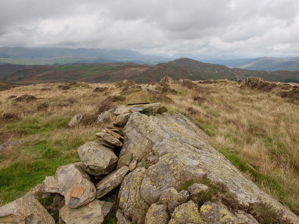
Wool Knott and Beacon Fell from Tottlebank Height
Height: 236 metres / 775 feet Grid reference: SD 26925 88512 Category: The Outlying Fells
Tottlebank Height
Heading for Tottlebank Height
Wool Knott and Beacon Fell from Tottlebank Height
Start Point: Woodland Fell road (SD 256 879)
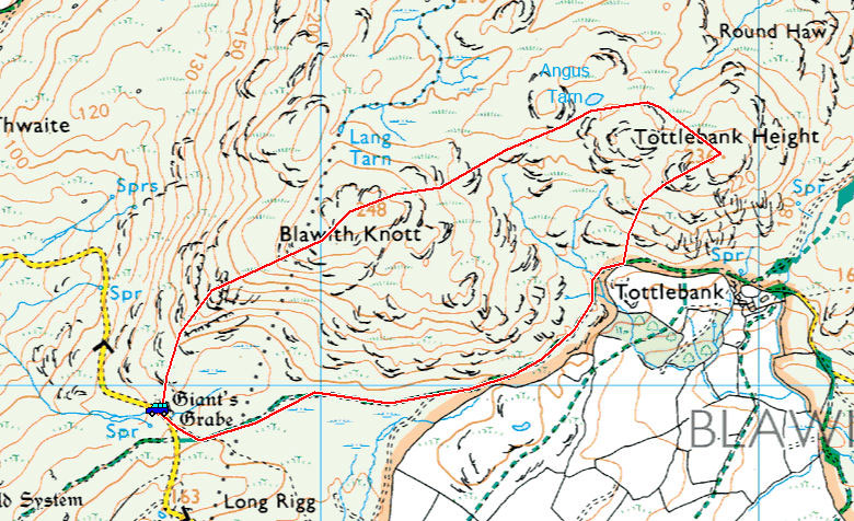
Woodland Fell road – Blawith Knott – Angus Tarn – Tottlebank Height – Woodland Fell road
Distance: 2 miles Total Ascent: 156 metres Time Taken: 1 hour 15 minutes Start Time: 14:15
Weather: Unseasonably warm, 19°C
The weather was quite strange this afternoon, it really warmed up and the sun was shining so I made use of it to have a quick walk up to Blawith Knott. When I arrived it was 19°C and the walk was completed in shirt sleeves – it was a real throw back to summer. By the end of the walk it had turned into a different day though, the brooding clouds eventually turned to rain although the warmth continued. I’ve just bought new hat and gloves though they won’t be needed just yet by the looks of things.

At the Giant's Grave

These two seem to know the way!

Light and shade - the Coniston fells don't appear to be fairing as well as us

Aye, aye - the windswept look for Fletcher

It was indeed a strange mix - really warm with big dark clouds to the west and blue skies to the east

At the western cairn on Blawith Knott

Dougal shows Fletcher what a proper fellwalking tongue should look like

We are still in the sunshine, but not for long I think

The path past Angus Tarn to Tottlebank Height

That is the view to Coniston Water from Tottlebank Height

Wool Knott in the sunshine, beyond is the darker shape of Beacon (Fell)

A dip in Angus Tarn for the boys

Darker skies now on the return leg - 5 minutes after getting in the car it started to rain (so good timing really)
Start point: Woodland Fell road (SD 256 879)
Woodland Fell Road – Blawith Knott (OF) – Angus Tarn – Tottlebank Height (OF) – Woodland Fell Road
Distance: 2 miles Total Ascent: 156 metres Time Taken: 1 hour 15 minutes Start Time: 14:50
Weather: Cool. 7oC
The weather was surprisingly good this afternoon – it felt windy at valley level, yet up on the fells not so bad! This is a lovely little walk, another of our favourites and not a soul to be seen around here.
Firstly, a few shots taken of Friday from Castlerigg Stone Circle…


Clough Head to Helvellyn.

Skiddaw and Blencathra.

A mono view of the circle. On with the walk...

Sunshine on the Giant's Grave.

Blawith Knott.

Dog - sheep, sheep - dog.

Nuclear explosion in the Duddon Estuary.

Connie and Dougal at the top.

The view from Blawith Knott.

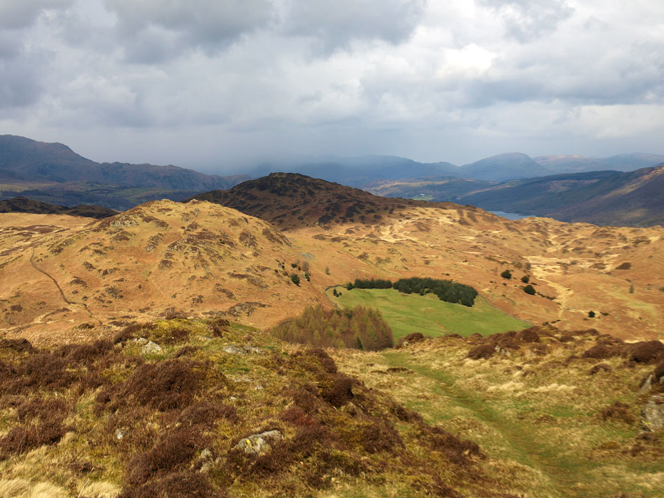
The way ahead with Angus Tarn centre left and Tottlebank Heights beyond.

Black Combe.

The Coniston fells from Blawith Knott.

Close up on the Coniston fells.

The snaking path to Angus Tarn.

Dougal has a dip.

Wool Knott and Beacon Fell. Up to the left you can just about make out Fairfield, complete with a snow covering - the first of the winter.

Tottlebank Height.

Setting sun.
Start point: Woodland Fell road (SD 256 879)
Woodland Fell Road – Blawith Knott (OF) – Angus Tarn – Tottlebank Height (OF) – Woodland Fell Road
Distance: 2 miles Total Ascent: 156 metres Time Taken: 1 hour 15 minutes Start Time: 17:25
Weather: Very warm. 25oC
I know, I know – we have not been getting out much recently, the main reason being I have a new job and that is taking up all my time at the moment; never fear, normal service will be resumed soon enough. Tonight we managed a quick evening walk up to Blawith Knott – it seemed a shame not to use the warm weather and the good news about Casper is that the incurable seemingly is (partly) curable, so he can once again join us at least on the smaller walks for now.
Firstly a holiday snap – we were in Provence in July taking in a bit of the Tour de France. We managed to see the Ventoux stage and this photo was taken two days later at the start in Vasion la Romaine. Nice to get so close to the Sky team…


L-R: Froome, Kennaugh, Porte, Thomas. On with the walk...

Black Combe across a sea of silver bracken.

Who's that new boy? Casper of course, he's on the comeback trail!

Warm and muggy on the top of Blawith Knott.

Looking for the rest of Angus Tarn.

That's a better place for a dip.

The hazy Coniston fells from Tottlebank Height.

Beacon Fell, Coniston Water to the right.

Evening sky.

All is sunny again now.
Start point: Woodland Fell road (SD 256 879)
Woodland Fell Road – Blawith Knott (OF) – Angus Tarn – Tottlebank Height (OF) – Woodland Fell Road
Distance: 2 miles Total Ascent: 156 metres Time Taken: 1 hour 15 minutes Start Time:14:25
Weather: Warm with the odd sunny spell. 20oC
It was another warm and muggy morning and there was a bit of rain around but it eventually cleared and was quite sunny for a period. We took this opportunity to head for Blawith Knott but the sun didn’t last the distance with the cloud catching us in the end.


The view from Burney along the Woodland Fell road - the bracken has suddenly taken on a definite brown tinge now as it dies off.

Giant's Grave.

Blawith Knott.

The hamlet of Woodland gets a brief spell of sunshine in the valley below.

Hot dogs.

On the climb.

The three amigos take in the view of the Duddon Estuary.

The Coniston fells looking a bit moody now, Wetherlam gets a brief spell of sunshine.

Dougal, Connie and Casper on Blawith Knott.

...and they're off! Following the clear path past Angus Tarn towards Tottlebank Height.

Enjoying a dip in Angus Tarn. If it was a bit deeper we may have joined them as well.

The splendid Angus Tarn.

Sitting pretty amongst the heather.

Looking the other way, towards Beacon Fell.

Tottlebank Height.

Dougal surveys the Crake Valley...

...whilst Casper descends our mini-Striding Edge down to the track.
Start point: Woodland Fell road (SD 256 879)
Woodland Fell Road – Blawith Knott (OF) – Angus Tarn – Tottlebank Height (OF) – Woodland Fell Road
Distance: 2 miles Total Ascent: 156 metres Time Taken: 50 minutes Start Time: 14:00
Weather: Warm and breezy. 17°C
I just managed a quick walk up to Blawith Knott today, one of my favourite lesser heights. It was lovely up there with a warm, summery breeze and the birdsong of Meadow Pipits for company. I love it up there.
At the Giant's Grave
These two seem to know the way!
Light and shade - the Coniston fells don't appear to be fairing as well as us
Aye, aye - the windswept look for Fletcher
It was indeed a strange mix - really warm with big dark clouds to the west and blue skies to the east
At the western cairn on Blawith Knott
Dougal shows Fletcher what a proper fellwalking tongue should look like
We are still in the sunshine, but not for long I think
The path past Angus Tarn to Tottlebank Height
A dip in Angus Tarn for the boys
Wool Knott in the sunshine, beyond is the darker shape of Beacon (Fell)
That is the view to Coniston Water from Tottlebank Height
Darker skies now on the return leg - 5 minutes after getting in the car it started to rain (so good timing really)
Start point: Woodland Fell road (SD 256 879)
Woodland Fell Road – Blawith Knott (OF) – Angus Tarn – Tottlebank Height (OF) – Woodland Fell Road
Distance: 2 miles Total Ascent: 156 metres Time Taken: 50 minutes Start Time: 13:00
Weather: Sunny with a breeze. 15ºC
After a busy week or two, I finally made it back onto the fells to try and catch some of the good weather. It was actually a bit colder than I expected today with the breeze but I still managed the walk in t-shirt and shorts and you can’t beat that for a feeling of freedom.

Blawith Knott route map.

Blawith Knott from the Woodland Fell road.

Black Combe and the Giant's Grave.

They're under starters orders on the path to Blawith Knott.

The Dunnerdale Fells and the distant Scafells from the first cairn on the climb.

Stickle Pike from the western cairn.

It's a little hazy today with a bit of a breeze blowing.

Casper and Dougal take a breather on the summit.

The Coniston fells.


The Scafells across Broughton Moor, White Pike and White Maiden to the right.

Casper and Dougal search for Angus Tarn.

Wool Knott and Beacon Fell from the path to Tottlebank Height.

The Old Man, Wetherlam and beyond from Tottlebank Height.

Contemplating the descent of Tottlebank Edge.

Looking back to Tottlebank Height from the bridleway.
Start point: Woodland Fell road (SD 256 879)
Woodland Fell Road – Blawith Knott (OF) – Angus Tarn – Tottlebank Height (OF) -Round Haw – Wool Knott (OF) – Slatestone Fell – Tottlebank Height (OF) – Woodland Fell Road
Distance: 4.7 miles Total Ascent: 417 metres Time Taken: 2 hours Start Time: 09:25
Weather: Cold and changeable with showers. 2C
The weather was completely odd in the south west Lakes this morning – when I set off it was cold and clear with an inversion over Coniston Water but I was soon overtaken by higher level cloud which was constantly clearing then dropping down again. At one point it started raining as well and you couldn’t tell what it would be like from one minute to the next. It was good to get out on a walk today though – it is Casper’s 7th birthday today, so Happy Birthday to him!

Blawith route map.

All looks nice and sunny on Blawith Knott at the start of the walk...

...but, looking the other way - look what's coming right for us across Kirkby Moor!

On the summit of an eerie Blawith Knott.

I don't know what you have been licking (ugh!) but Happy Birthday Casper, 7 today!

A glimpse of the Coniston Fells.

Dougal heads for Tottlebank Height. Beyond, there is a temperature inversion over Coniston Water and the Crake Valley.

Beacon Fell left, Angus Tarn centre and Tottlebank Height on the right with the Coniston Water inversion visible along its length.

Angus Tarn is frozen today Dougal!

A frozen pool on the way to Tottlebank Height.

Wool Knott and Beacon Fell.

Inversion in the Crake Valley.

Casper and Dougal don't know what to make of the strange light.

Beacon Fell and Tarn from the summit of Wool Knott.

Sunlight over Morecambe Bay.

The light is giving the inversion an other worldly look.

The clouds above are thickening now.

Crake Valley panorama.

Dramatic sky, dramatic inversion from Slatestone Fell. Now there's an odd thing - it was absolutely chucking it down now and freezing cold but I didn't think you could get an inversion in those conditions.

Coniston Water in the rain from Slatestone Fell.

Walking the damp, walled highway on the way back - Tottlebank Height ahead.

It's all change over Wool Knott now!

Looking back to Slatestone Fell, the mist now clearing and the rain has gone.

A panoramic view from the same place.

The mist is constantly clearing and then reforming.

Dead tree on Tottlebank Height.

I climbed back to the top of Tottlebank Height to have another look around, here looking to Wool Knott and Beacon Fell.

Clearing Coniston Fells from Tottlebank Height.

Kirkby Moor.

Big sky looking towards Black Combe now under a thick blanket of cloud.

A final dip and a drink for the boys at the foot of Blawith Knott.
Start point: Woodland Fell road (SD 256 879)
Woodland Fell Road – Blawith Knott (OF) – Angus Tarn – Tottlebank Height (OF) – Woodland Fell Road
Distance: 2 miles Total Ascent: 156 metres Time Taken: 50 minutes Start Time: 08:30
Weather: Overcast. 16C
This must be about as far south and as far away in the Lake District as I could get from my last walk up to Binsey. The truth is I didn’t expect to get out anywhere at all this week but there is a lull in the shop preparations in Keswick as they are screeding the floor and we can’t get near today. That made today’s walk all the better and I always find Blawith Knott a good shorter walk.
The Keswick shop open this weekend so if you are in the area, please call in and see us – we will all be there including Dougal and Casper and it would be great to have a chat.

Blawith Knott route map.

Giant's Grave is almost completely obscured by the bracken (centre right) looking across to Black Combe.

A spring in their steps on the way to Blawith Knott.

Looking back down to the Duddon Estuary.

Stickle Pike, the Dunnerdale Fells and Caw from the western summit cairn.

Casper and Dougal on Blawith Knott.

The Coniston fells from Blawith Knott.

The two cairns and Whitfell.

The cloud is lifting from the Coniston fells.

Windmills and spoil heaps on Kirkby Moor.

Beacon Fell and Wool Knott.

Heading for dry Angus Tarn.

The boys have a swim!

No water here either Casper.

Tottlebank Height and the merest glimpse of Coniston Water to the right of Beacon Fell.

Tongue unfurled Casper.

Descending the mighty Tottlebank Height Edge.

Well, I guess they found some water at last - nice!

Those two are getting cleaned up in the beck at the base of Blawith Knott (bottom).
Start point: Woodland Fell road (SD 256 879)
Woodland Fell Road – Blawith Knott (OF) – Angus Tarn – Tottlebank Height (OF) – Woodland Fell Road
Distance: 2 miles Total Ascent: 156 metres Time Taken: 1 hour 30 minutes Start Time: 14:30
Weather: Sunny, 12C
It was really quite warm and sunny today, perhaps this is the real start of Spring? Everything seems to be beginning to bud and all the daffodils around are in full flower – anyway, it was good to get some fresh air and not have to bother about keeping dry for a change.

Blawith Knott route map.

The Giant's Grave.

Connie and her friend Abbie looking forward to enjoying the Spring weather.

The blue skies and sunshine seemed to be coming in from the south west, here looking across to the Dunnerdale fells from the climb.

The Coniston fells with the distant Scafell and Scafell Pike visible in the centre.

The view from the first summit cairn on Blawith Knott.

Looking in the opposite direction to Black Combe.

Dougal and Casper on the summit.

A smiling group shot.

The two cairns on Blawith Knott looking towards Buckbarrow (the Black Combe one).

Only remnants of snow on the southern face of Scafell and Scafell Pike now.

Following the looping path past Angus Tarn to Tottlebank Height.

The Coniston fells from above Angus Tarn.

Try keeping Casper and Dougal out of there!

A dip in Angus Tarn for the boys.

The scissors are being warmed up for you Casper!

Beacon Fell.

On Tottlebank Height.

The eastern fells beyond Beacon Fell and the merest glimpse of Coniston Water.

Pretty in pink these two are.

Caw and the Dunnerdale fells.

The sky over Morecambe Bay.

Blawith Knott.
Start point: Woodland Fell road (SD 256 879)
Woodland Fell Road – Blawith Knott (OF) – Angus Tarn – Tottlebank Height (OF) – Woodland Fell Road
Distance: 2 miles Total Ascent: 156 metres Time Taken: 1 hour
Weather: Sunny spells. 14C.
It was a pleasant autumn afternoon for a stroll along to Blawith Knott and Tottlebank Height with the showing itself at intervals. These fells seemed to be on the line between the sunny and bright weather to the south and west and darker, more ominous looking weather to the north and east. It was to see that Angus Tarn was full again, you may remember that when we visited in July it was completely dry. I also managed to visit a ‘Great Slab’ and ‘Sharp Edge’ today, amazing what you can find on these smaller fells!

Blawith Knott route map.

Tottlebank Height over a tarn on Heathwaite Fell.

The welcoming party - she could be an honorary Beardie with a haircut like that! I like the way the tag goes right through her ears - come in number 4 billion and one, your time is up...

Sunshine over me and a dark sky over Blawith Knott.

Black Combe from Giant's Grave.

Making a dash for it.

The sunshine glinting on the beautiful Duddon Estuary.

The Dunnerdale fells from the first cairn on the summit.

Dougal and Casper on Blawith Knott.

The fell dog surveys all he commands on the summit of Blawith Knott.

The [path to Tottlebank Height leads straight past Angus Tarn.

Angus Tarn is full again today.

Casper has a dip whilst Dougal decides to stay with his dad.

Casper in Angus Tarn.

The Great Slab of Tottlebank Height?

Beacon Fell from Tottlebank Height with the smallest glimpse of Coniston Water to the right of it.

Windswept on Tottlebank Height.

Descending the mini Sharp Edge from Tottlebank Height!

Autumn track.
Start point: Woodland Fell road (SD 256 879)
Woodland Fell Road – Blawith Knott (OF) – Lang Tarn – Tottlebank Height (OF) – Woodland Fell Road
Distance: 2 miles Total Ascent: 156 metres Time Taken: 2 hours
Weather: Frequent showers. 21C.
Today we had a short walk up to Blawith Knott which lies above the Woodland valley and we were joined by our friends Roger and Ann Hiley along with their dogs Harry and Bethan. The weather was none too promising when we set off as the rain was quite heavy, but thankfully it cleared and the walk was completed in a mixture of bright sunshine and frequent showers.

Blawith Knott route map.

Giant's Grave is just about visible over the tall bracken today.

It was a bit of a damp start to the walk on the path to Blawith Knott but we were hopeful of brighter weather to come.

By the time we reached the first summit cairn things had started to clear a little.

To the west, blue sky over the Duddon Estuary and heading for Black Combe.

A group shot on the summit - Connie, Roger and Ann accompanied by the three dogs - Harry, Bethan and Casper.

Me and Connie swapped places for this one.

The Coniston fells from the summit.

Beacon Fell and Wool Knott.

The Duddon Estuary and Black Combe.

The Dunnerdale fells and the two cairns on the summit of Blawith Knott. Ann and Connie take a short detour to the north from the summit which leads down to Lang Tarn.

Lang Tarn (towards the bottom of the photo) which along with Foxes Tarn is reputed to be the smallest named tarn in the Lake District.

Just big enough to fit three dogs in, so that's alright then!

Another of the frequent showers and it is hoods up for Connie and Ann heading across to Angus Tarn.

Blue sky behind once more looking back to Blawith Knott after rejoining the main path.

Connie and the dogs wonder what on earth has happened to all the water in Angus Tarn.

Doggy photo call on Tottlebank Height.

Blawith Knott from the descent of Tottlebank Height.

Great Burney to the left from the now warm descent through the bracken.

Blawith Knott from the Woodland Fell road.
Start point: Woodland Fell road (SD 256 879)
Woodland Fell Road – Blawith Knott (OF) – Tottlebank Height (OF) – Woodland Fell Road
Distance: 2 miles Total Ascent: 156 metres Time Taken: 50 minutes
Weather: Sunny. 17C.
It was a lovely afternoon for a short walk to the ever delightful Blawith Knott and Tottlebank Height. It felt like summer was here once more and it was a joy to walk over this way today. Of course we took in the previously self-named Angus Tarn where Casper naturally stopped for a cooling dip, although it is rapidly disappearing to take on its dried up summer status (see the route map as it has been officially named by the StridingEdge mapping service!).

Blawith Knott route map.

Giant's Grave.

The path to Blawith Knott.

The Coniston fells from the first cairn on the ridge.

A similar view from higher up at the western summit cairn.

The summit of Blawith Knott, the Coniston fells remain the main view with the Scafells in view on the distant left.

A panoramic view from Blawith Knott.

King Casper on Blawith Knott.

A close up on the Coniston fells.

The Dunnerdale fells.

Scafell and Scafell Pike.

Dow Crag and The Old Man.

Black Combe and the two summit cairns.

Casper remembers at Angus Tarn. Do you remember...

Angus, the bark monster, in Angus Tarn 9th April 2008

The Coniston fells across Angus Tarn.

Tottlebank Height.

Beacon Fell is central with the merest glimpse of Coniston Water with Fairfield and the Far Eastern fells beyond.

A beautiful summer day.

Casper is enjoying the sunshine here on Tottlebank Height.

Blawith Knott.
Start point: Woodland Fell road (SD 256 879)
Woodland Fell Road – Blawith Knott (OF) – Tottlebank Height (OF) – Woodland Fell Road
Weather: Long sunny spells. 8oC.
The southern Lakes had it good today looking at the weather further north. Furness and the surrounding fells basked in sunshine whilst the higher fells still looked decidedly wintry and we had a pleasant and enjoyable stroll across this largely unknown and often ignored area.

The Coniston fells and Blawith Knott from Heathwaite Fell.

Black Combe and Woodland.

Climbing to Blawith Knott.

Black Combe and the Duddon Estuary.

The Dunnerdale and Coniston fells from the first cairn. In the distance are the Scafells which were in and out of cloud all afternoon.

Angus and Casper on the top of Blawith Knott.

Angustus.

The Duddon Estuary from the summit cairn.

Lakeland sky.

Casper and Angus in Angus Tarn.

Not its real name of course but seeing as it doesn't have one of it own...!

Angus, the bark monster, in Angus Tarn (SD 266 886 if you want to find it)...

Heading for Tottlebank Height.

Wool Knott and Beacon Fell from Tottlebank Height. There is a glimpse of Coniston Water from here with the familiar whaleback of Red Screes beyond. Those showers over the central fells look like snow to me.

Start point: Woodland Fell road (SD 256 879)
Woodland Fell Road – Blawith Knott (OF) – Tottlebank Height (OF) – Woodland Fell Road
Distance: 2 miles Total Ascent: 245 metres Time Taken: 1 hour
Weather: Sunny. 11oC.
It was the first time we have had any sunshine for ages today, but it appeared only on the very edge of the Lake District. Looking further north it still looked a bit grim, so we had a walk to the pleasant outliers of Blawith Knott and Tottlebank Height. The camera maladies of earlier in the week are all sorted out now, so it’s business as usual!


Blawith Knott across Subberthwaite Common.

Dunnerdale from the Giant's Grave.

Heading for Blawith Knott.

Stickle Pike and the Dunnerdale Fells.

Close up on Stickle Pike.

Caw.

The view from the summit of Blawith Knott.

Angus and Casper basking in the sunshine on Blawith Knott.

Tottlebank Height - the route is over to the tarn first.

Beacon Fell.

The higher fells are not getting any decent weather - here the Coniston fells are covered in cloud.

A nice place for a swim in the un-named tarn for these two.

At the end of the walk, the sun was suddenly switched off! Looks like we'd had our quota for the day (or week!). Here, the merest glimpse of Coniston Water can be seen beyond Beacon Fell.
Start point: Woodland Fell road (SD 256 879)
Woodland Fell Road – Blawith Knott (OF) – Tottlebank Height (OF) – Woodland Fell Road
Distance: 2 miles Total Ascent: 245 metres Time Taken: 1 hour
Weather: Overcast with showers. 16oC.
It has been bucketing down with rain for the last 24 hours in the South Lakes, but we managed to find a clear hour for a short walk up to Blawith Knott. The autumn brown bracken and coppery colours are obvious now and make a change from the uniform green of summer. Anyone up on the Coniston fells today would have had a mixed day of weather as I could see the clouds constantly lift and then close in on them from this great viewpoint.


Heading for Blawith Knott.

Clouds over the Coniston fells.

Caw.

Stickle Pike.

Beacon Fell.

The Duddon Estuary.

Angus.

Casper.

Black Combe from the top of Blawith Knott.

Looking north-east from the summit cairn.

On to Tottlebank Height and the clouds are lifting over Coniston.

The merest glimpse of Coniston Water to the right of Beacon Fell.

Coniston Old Man and Wetherlam are all clear now.

Wetherlam.

Coniston Old Man.

Dow Crag.

Angus on Tottlebank Height.
Start point: Woodland Fell road (SD 256 879)
Woodland Fell Road – Blawith Knott (OF) – Lang Tarn – Tottlebank Height (OF) – Woodland Fell Road
Distance: 2 miles Total Ascent: 245 metres Time Taken: 2 hours
Weather: Sunny, clearing. 11oC.
The overnight rain cleared this morning and the sun eventually turned up for our walk up to Blawith Knott and Tottlebank Height. It was a lovely morning for Casper’s first fell walk (of many?) and Connie’s final one of the Easter holiday’s before returning to school.


Black Combe from Giant's Grave - the 'headstone' is on the right.

Climbing up to Blawith Knott.

Looking over to Black Combe from further up.

The Dunnerdale Fells, Stickle Pike in the centre.

The Scafell range - still a bit of snow on the very highest tops.

Looking north-east over Beacon Fell to Red Screes, centre, with Helvellyn and Fairfield to the left.

Golden sands of the Duddon Estuary.

Connie, Angus and Casper on the summit of Blawith Knott.

Angus.

Caw, left, the Scafell range through the gap and the Coniston fells to the right.

The Dunnerdale Fells - Stickle Pike and Caw flank the serrated edge of Fox Haw - Raven's Crag - The Knott.

The Coniston fells across the un-named tarn on the way to Tottlebank Height. View Casper the Porpoise in the tarn!

A northerly panoramic view from Tottlebank Height.

Wetherlam.

The Old Man of Coniston, the summit cairn visible.

Stickle Pike.

Casper.

Casper and Angus eye up Connie's crisps!

Dow Crag and The Old Man.
Start point: Woodland Fell road (SD 256 879)
Woodland Fell Road – Blawith Knott (OF) – Lang Tarn – Tottlebank Height (OF) – Woodland Fell Road
Distance: 2 miles Total Ascent: 245 metres Time Taken: 2 hours
Weather: Grey and overcast. 16°C.
It was grey and overcast yet again this afternoon for our short walk over Wainwright Outlying fell Blawith Knott. The heavy clouds threatened rain which thankfully didn’t materialise and we had an enjoyable walk with David and Daniel, who are holidaying in the area this week.

Blawith Knott route map.

The Duddon Estuary from the first cairn on Blawith Knott.

On the summit of Blawith Knott, low clouds spoiling the view today but everyone seems to be enjoying it.


Daniel explores the dried up, un-named tarn on the way to Tottlebank Height.

Beacon Fell and Wool Knott with the merest glimpse of Coniston Water from Tottlebank Height.

Blawith Knott from a heather clad Tottlebank Height.

Great Burney.

The Dunnerdale Fells and Stickle Pike across Woodland and the Lickle Valley.
Start point: Woodland Fell road (SD 256 879)
Woodland Fell Road – Blawith Knott (OF) – Lang Tarn – Tottlebank Height (OF) – Woodland Fell Road
Distance: 2.5 miles Total Ascent: 245 metres Time Taken: 1 hour 40 minutes
Weather: Cloudy with sunny spells. 14oC.
Today we had a family outing to the virtually unfrequented Blawith Knott which lies between Broughton-in-Furness and Torver. This is another fell that is small in stature and is easy going, yet offers magnificent views to the Coniston fells.
This walk follows the one described in Wainwright’s Blawith Knott chapter in his book ‘The Outlying Fells of Lakeland’, page 108.

Blawith Knott route map.

The sun shines on Stickle Pike.

Heading up to Blawith Knott.

The first cairn, looking to Black Combe.

The Duddon Estuary from Blawith Knott.

Louise, Connie and Angus on Blawith Knott. Hold on tight!

The north-westerly view from Blawith Knott.

Lang Tarn, the smallest named tarn in Lakeland.

The Coniston fells across an un-named tarn on Tottlebank Height.

Caw from Tottlebank Height.
Start point: Woodland Fell road (SD 256 879)
Woodland Fell Road – Blawith Knott (OF) – Lang Tarn – Tottlebank Height (OF) – Woodland Fell Road
Distance: 2.4 miles Total Ascent: 230 metres Time Taken: 50 minutes
Weather: Grey and overcast with rain showers. 13oC.
Today’s walk visits the little frequented Woodland Valley which lies between the Duddon Estuary and Coniston. It was grey and overcast with no views to the high fells; at least the temperature is getting warmer – it felt like Spring today.
This walk follows the one described in Wainwright’s Blawith Knott chapter in his book ‘The Outlying Fells of Lakeland’, page 108.

Blawith Knott route map.

Giant's Grave, a Bronze Age barrow. It is a headstone with a small circle of stones nearest to the camera.

Great Burney across Subberthwaite Common.

Looking towards the Duddon Estuary from Blawith Knott.

Lang Tarn - 'shares with Foxes Tarn, Scafell, the distinction of being the smallest named tarn in Lakeland'.

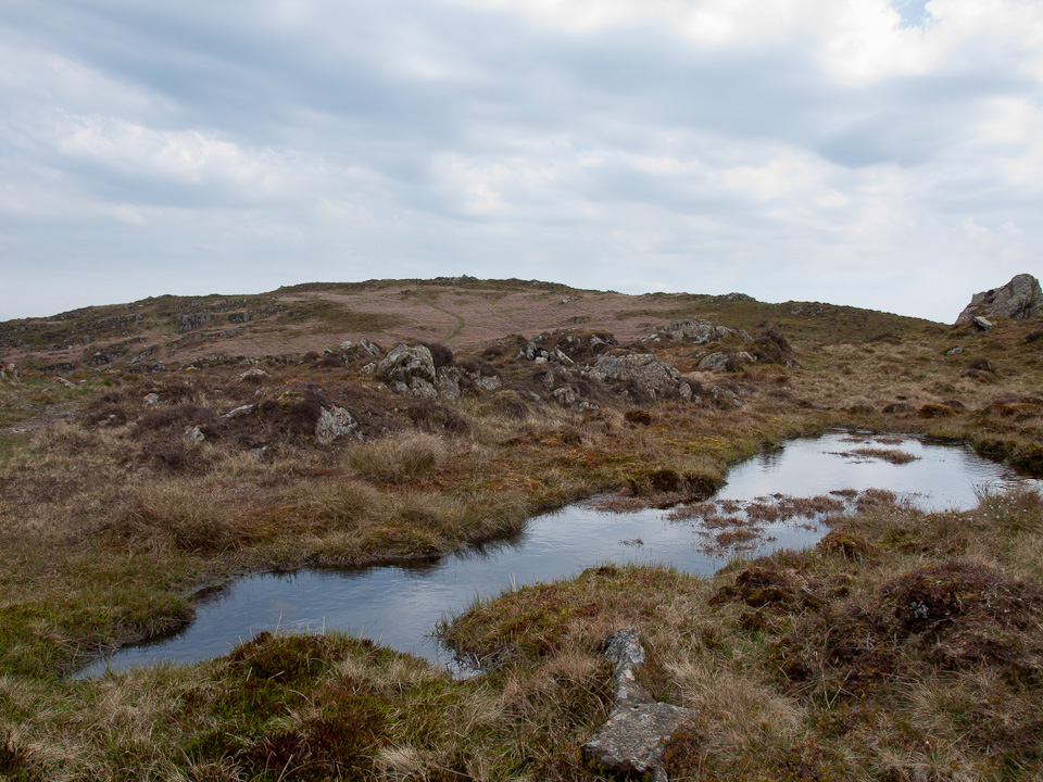
An un-named tarn on Tottlebank Height.

Angus explores Tottlebank Height summit.


Blawith Knott.